January 25 , 2026.
Hawaii , Kilauea :
HAWAIIAN VOLCANO OBSERVATORY DAILY UPDATE , U.S. Geological Survey
Saturday, January 24, 2026, 7:35 AM HST (Saturday, January 24, 2026, 17:35 UTC)
19°25’16 » N 155°17’13 » W,
Summit Elevation 4091 ft (1247 m)
Current Volcano Alert Level: WATCH
Current Aviation Color Code: ORANGE
Activity Summary:
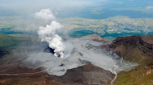
Precursory overflows began from the north vent at 3:52 a.m. HST and continued since then. The forecast based on inflationary tilt models for the onset of the next lava fountaining episode is most likely today, January 24, or possibly tommorrow, January 25, if inflation is interrupted. Micro-seismicity continues in the summit region, but is much less energetic than earlier this week. No significant activity has been noted along Kīlauea’s East Rift Zone or Southwest Rift Zone.
Summit Observations:
Webcam views of Halemaʻumaʻu showed consistent strong glow from both the north and south vents, with frequent spattering at flames from the north vent until early morning. Spattering increased in intensity and the north vent began overflowing at 3:52 a.m. HST. Low fountains increased in height to 10-15 feet (3-5 meters) and effusion rate from the north vent at about 4:47 a.m. HST and overflows increased in size. The north vent has remained continuously active since the onset of overflows. The south vent has overflowed eight times this morning (4:11, 5:18, 6:13, 6:28, 6:40, 6:57, 7:14, 7:22 a.m. HST). The first four were short-lived and remained close to the vent. The four latest overflows were larger lasting 10-15 minutes and sent flows out onto the floor of Halemaʻumaʻu crater. Constant low-level tremor continues this morning.
HAWAIIAN VOLCANO OBSERVATORY STATUS REPORT , U.S. Geological Survey
Saturday, January 24, 2026, 12:18 PM HST (Saturday, January 24, 2026, 22:18 UTC)
Activity Summary:
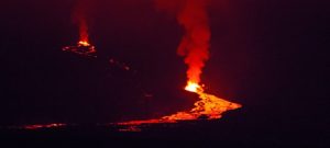
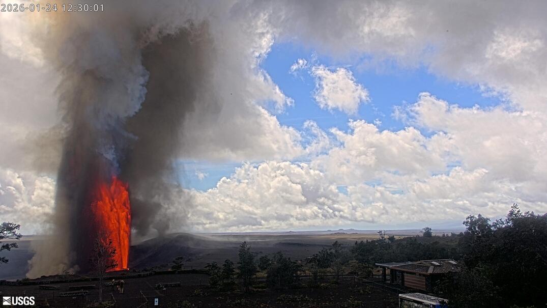
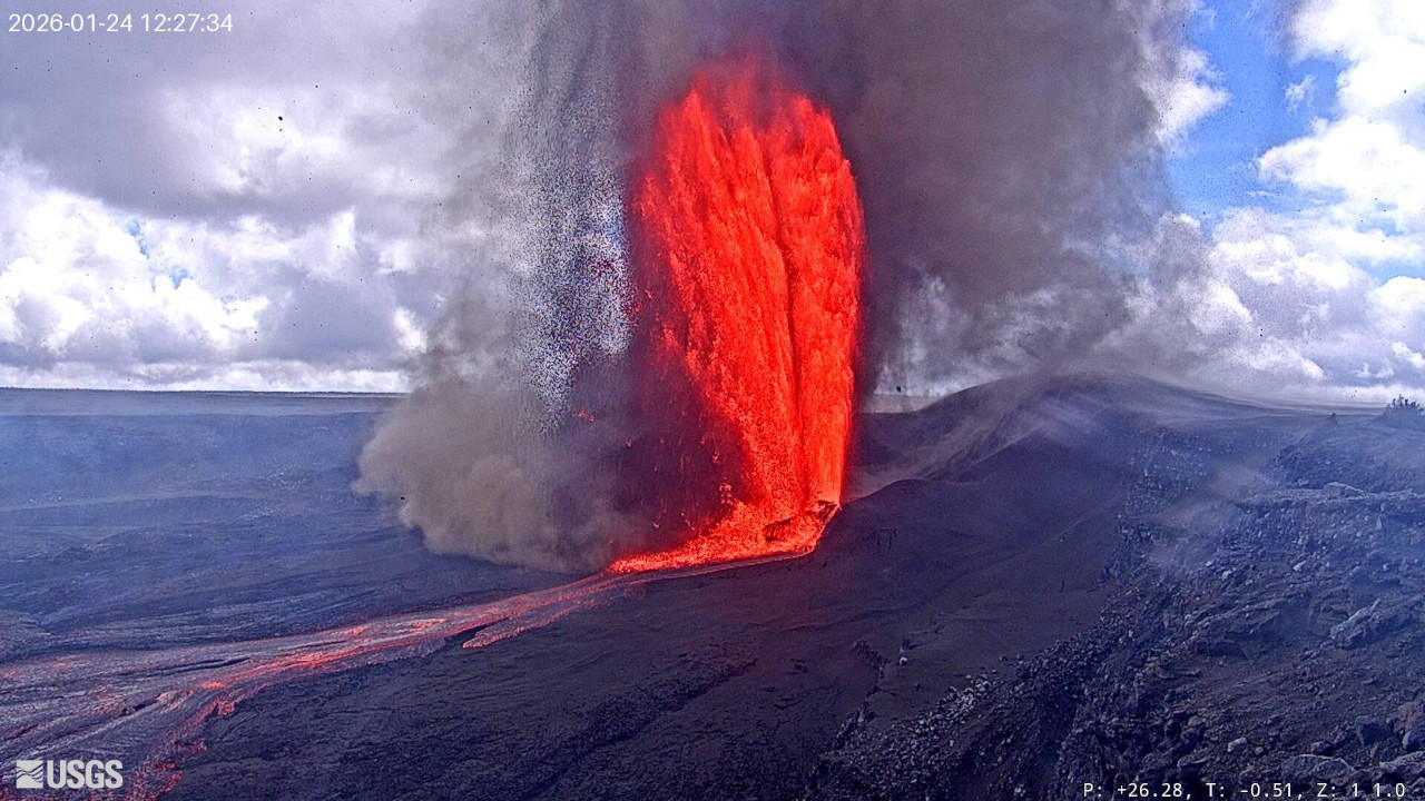
Episode 41 of the ongoing Halemaʻumaʻu eruption began around 11:10 a.m. HST on January 24, 2026. Tephra fall has been reported in public viewing areas within Hawaiʻi Volcanoes National Park, Volcano Village, Mauna Loa Estates, and Ohia Estates. As of 12:10 p.m., both north and south vent fountains were over 500 m (1640 feet) tall.
The tiltmeter at UWD started recording deflation at about 10:15 a.m. this morning, and summit seismometers started recording increasing tremor around 11:10 a.m. The episode started at 11:10 a.m. with both vents fountaining. By 12:10. p.m., both north and south vent fountains were about 500 m (1640 feet) tall.
HAWAIIAN VOLCANO OBSERVATORY STATUS REPORT , U.S. Geological Survey
Saturday, January 24, 2026, 2:22 PM HST (Sunday, January 25, 2026, 00:22 UTC)
Activity Summary:
Episode 41 of the ongoing Halemaʻumaʻu eruption began around 11:10 a.m. HST on January 24, 2026. North and south vent fountain heights peaked just after 12:30 p.m., with maximum fountain heights estimated around 460 to 480 m (1500-1575 feet). Widespread tephra fall has been reported in the National Park and surrounding areas including communities to the north of the National Park. As of 2:15 p.m., north vent fountains are about 200 m (650 feet) high and south vent fountain is about 300 m (1000 feet) high.
Weak surface winds in combination with stronger upper-level winds blowing to the east have resulted in widespread tephra fall to the north and east of the eruptive vents. Small to large clasts, some up to grapefruit size, have been reported at many public viewing areas within Hawaiʻi Volcanoes National Park, including Uēkahuna, Kūkamāhuākea (Steam Vents), Volcano House, and Keanakākoʻi. Some tephra at Keanakākoʻi was reported to still be hot as it fell.
Smaller tephra has been reported in communities including Volcano Village, Mauna Loa Estates, Ohia Estates, Mountain View, and Fern Acres. Unconfirmed reports from other communities up to 30 kilometers (20 miles) to the east such as Mountain View, Kurtistown, and Ainaloa Estates may be experiencing fallout of fine particles as the plume continues to disperse downwind in a general easterly direction.
HAWAIIAN VOLCANO OBSERVATORY STATUS REPORT , U.S. Geological Survey
Saturday, January 24, 2026, 8:11 PM HST (Sunday, January 25, 2026, 06:11 UTC)
Activity Summary:
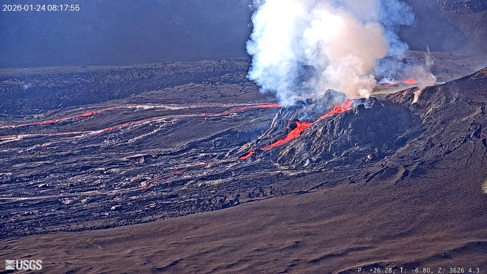
Episode 41 lava fountaining from the north vent stopped at approximately 7:26 p.m. HST on January 24. The south vent dropped rapidly, then jetted back up for 30 seconds just prior to the eruption ceasing at 7:29 p.m. HST January 24. Episode 41 ended after 8 hours and 18 minutes with both the north and south vents active for most of the eruption. Tephra fall may continue for several hours as ash settles out of the atmosphere. The highest peak or instantaneous effusion rate of 1050 cubic yards (800 cubic meters) per second occurred just after 12:30 p.m. HST on January 24
.
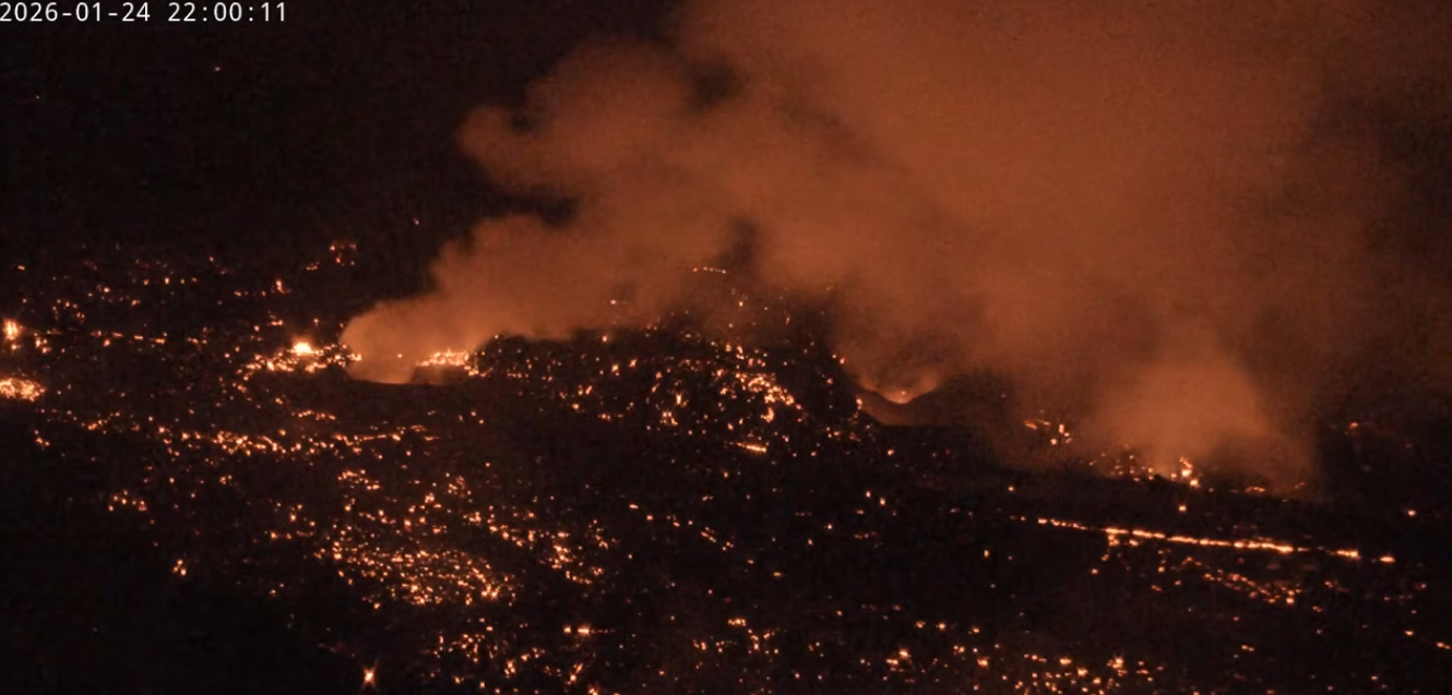
Episode 41 ended with an average effusion rate of 470 cubic yards per second (360 cubic meters per second). An estimated 14 million cubic yards (11 million cubic meters) of lava erupted and covered about 80-85% of Halemaʻumaʻu crater floor. The Uēkahuna tiltmeter (UWD) recorded about 31 microradians of deflationary tilt during episode 41. As of 8:10 p.m. HST, UWD has already recorded about 0.6 micrometers of inflation since the end of episode 41.
Source et photos : HVO
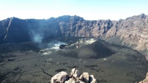
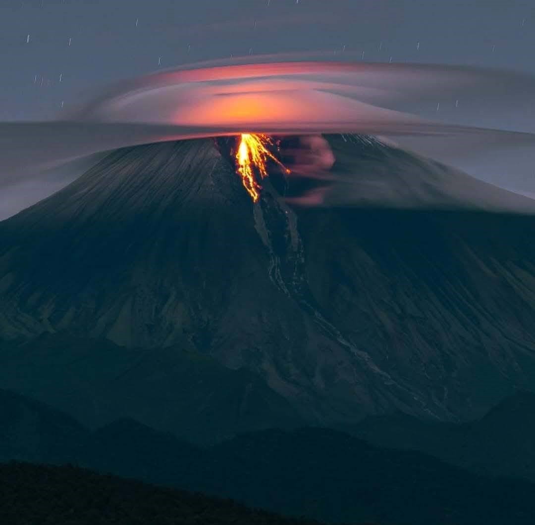
Indonesia , Lewotobi Laki-Laki :
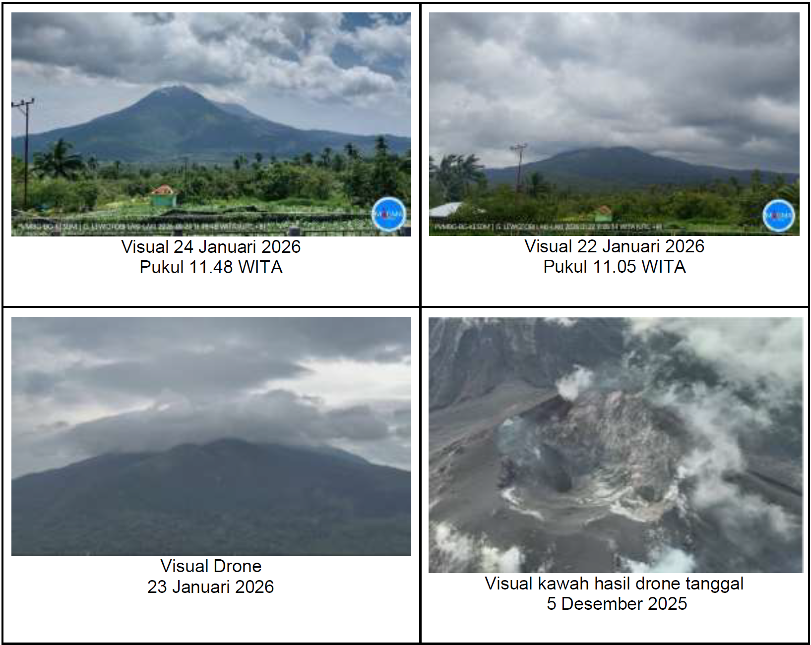
Visual monitoring over the past week has shown that the volcano was clearly visible until it became obscured by thick fog. Smoke from the main crater was observed to be white, with low to medium intensity, rising approximately 50 to 300 meters above the summit. An avalanche occurred, but the distance and direction of the landslide were not visually observed.
Seismicity data from January 15 to 22, 2026, included 4 earthquakes with fallout, 15 gust earthquakes, 133 non-harmonic earthquakes, 22 low-frequency earthquakes, 166 deep volcanic earthquakes, 7 local tectonic earthquakes, 41 distant tectonic earthquakes, and 1 flood/lava vibration.
Seismicity data from January 15 to 22, 2026:
There were 4 avalanche earthquakes, 15 emission earthquakes, 133 non-harmonic tremors, 22 low-frequency earthquakes, 166 deep volcanic earthquakes, 7 local tectonic earthquakes, 41 distant tectonic earthquakes, and 1 flood/lahar tremor.
In early and mid-January 2026, deep volcanic earthquakes occurred sporadically before decreasing significantly, particularly during the second week of January. Seismic activity was dominated by non-harmonic tremors, which fluctuated and tended to weaken, reflecting residual fluid activity within the system. Tornillo-type earthquakes were recorded in very small numbers and did not persist; their occurrence is interpreted as an adjustment of post-eruptive fluids, as they were not accompanied by any increase in shallow earthquakes, sustained tremors, or eruptive activity. Surface activity was limited to low-intensity eruptions and avalanches.
GNSS deformation data from October 2025 to January 2026 at the CFLT and GNRB stations showed predominantly lateral, non-radial movement with no trend toward consistent vertical inflation. This phenomenon was interpreted as post-eruptive relaxation rather than a buildup of shallow magma pressure. These data are consistent with those from tiltmeters, which revealed gradual changes without significant acceleration or overstress, indicating the absence of magma pressure buildup in the shallow zone. The most recent tiltmeter data (January 9–2, 2026) showed slow and steady changes in inclination, without abrupt changes in slope or acceleration of deformation. No consistent inflation pattern was observed between stations. This is consistent with decreased seismicity and the absence of magma input to the shallow zone. Bi-weekly GNSS data also showed asymmetrical lateral movement patterns and no vertical uplift, supporting the interpretation that the system is in a post-eruptive stabilization and relaxation phase.
Following visual and instrumental analysis, the activity level of Mount Lewotobi Lakilaki remains at Level III (SIAGA). Social distancing recommendations are as follows: the public and tourists are advised to avoid contact with the eruptive center within a 5 km radius, remain calm, and follow the instructions of local authorities. The public is also asked to disregard information from unreliable sources.
Furthermore, residents of at-risk areas are urged to be vigilant regarding the risk of lahar flows during periods of heavy rainfall, particularly in the watersheds originating at the summit of Mount Lewotobi Lakilaki, such as Nawakote, Boru, Padang Pasir, Klatanlo Dulipali, Nobo, Hokeng Jaya, and Nurabelen. In the event of ashfall, those affected are advised to wear a mask or cover their nose and mouth to protect their respiratory system.
Source et photo : PVMBG.
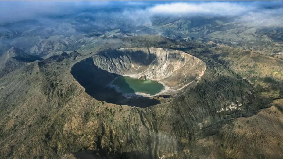
Mexico , El Chichon :
High activity at Chichón volcano in Chiapas: alerts triggered
The lake that formed in the crater, once dominated by algae, is now composed of sulfates and silica.
The physicochemical changes that have occurred in recent years in the lake and its hydrothermal system necessitate enhanced geochemical monitoring of the volcano, according to Patricia Jácome Paz, a researcher in the Department of Natural Resources at the Institute of Geophysics (IGf) of the National Autonomous University of Mexico (UNAM).
Following the major eruption of 1982, a turquoise hydrothermal lake formed in the crater—approximately one kilometer in diameter and 200 meters deep—containing sulfurous waters with a temperature approaching 100 degrees Celsius, she indicated.
During the conference « The Chichón Volcano: Dynamics and Recent Observations, » presented as part of the IGf volcanology seminar, the physicist and PhD in Earth Sciences explained:
Samples have been taken from the volcano’s lake, located in northern Chiapas, for 20 years. Recently, variations in solute fluxes (substances that dissolve in other substances, called solvents, to form a solution) have been detected throughout the system. Hollow spheres of native sulfur are present in the water, formed by the bubbling of gas through a mass of liquid sulfur.
These spheres float on the surface of the lake for a short time before breaking apart, indicating the presence of a reservoir of liquid sulfur at the bottom, the temperature of which can reach 118 degrees Celsius, she added.
In recent years, the volcano has undergone changes, notably in the lake’s coloration, which has shifted from a predominance of algae to one of sulfates and silica—characteristics indicative of volcanic lake activity.
Furthermore, significant gas emissions from the volcano’s crater are reaching the surface, potentially causing health problems. This risk is all the more concerning given that the area is a tourist destination, despite warnings about the dangers involved. Jácome Paz recommended enhanced collaboration between volcanologists for data interpretation and recommendation development, risk management specialists, community monitoring teams, and communication experts.
Source : Vertigopolitico.
Photo : DGCS UNAM.
Ecuador , Sangay :
DAILY REPORT ON THE STATE OF SANGAY VOLCANO, Saturday, January 24, 2026.
Geophysical Information Institute – EPN.
Surface Activity Level: High, Surface Trend: No Change
Internal Activity Level: Moderate, Internal Trend: No Change
Seismicity: From January 23, 2026, 11:00 AM to January 24, 2026, 11:00 AM:
Seismicity:
The table below shows the number of seismic events recorded at the reference station:
Explosions (EXP): 350
Precipitation/Lahars:
No precipitation was recorded in the volcano area. **In the event of heavy rain, the accumulated materials could be remobilized, generating mud and debris flows that would cascade down the volcano’s flanks and flow into nearby rivers.**
Ash emissions/columns:
This morning, the monitoring camera system observed a gas and ash plume reaching an altitude of less than 1,000 meters above the crater, drifting southwest. The GOES-19 satellite system detected a gas and ash plume reaching an altitude of less than 800 meters above the crater, drifting west-southwest. Related to this activity, the Washington VAAC issued two reports of emissions reaching altitudes between 1,400 and 2,000 meters above the crater, drifting south and southwest.
Gas:
The MOUNTS satellite system detected 234.8 tons of sulfur dioxide (SO₂), measured at 1:33 p.m. local time on January 23, 2026.
Other monitoring parameters:
Over the past 24 hours, the FIRMS satellite system recorded 12 thermal anomalies, as did the MIROVA-VIIRS 1 and MIROVA-MODIS 2 systems.
Observation:
From yesterday afternoon until the time of writing this report, the volcano remained mostly shrouded in cloud.
Alert level: Yellow
Source : IGEPN
Photo : lenin.izaa via Volcan Sangay / FB.
Guatemala , Fuego :
Atmospheric conditions: Clear skies
Wind: East
Precipitation: 0.0 mm
Activity
During the night and early morning, weak to moderate degassing was recorded, with fumaroles reaching approximately 200 m above the crater and dispersing westward. Explosive activity continued with 8 to 12 weak to moderate explosions per hour, generating ash plumes between 4,300 and 4,700 m altitude, which drifted westward. This activity caused fine ashfall on Panimache 1 and 2, Morelia, and other nearby localities.
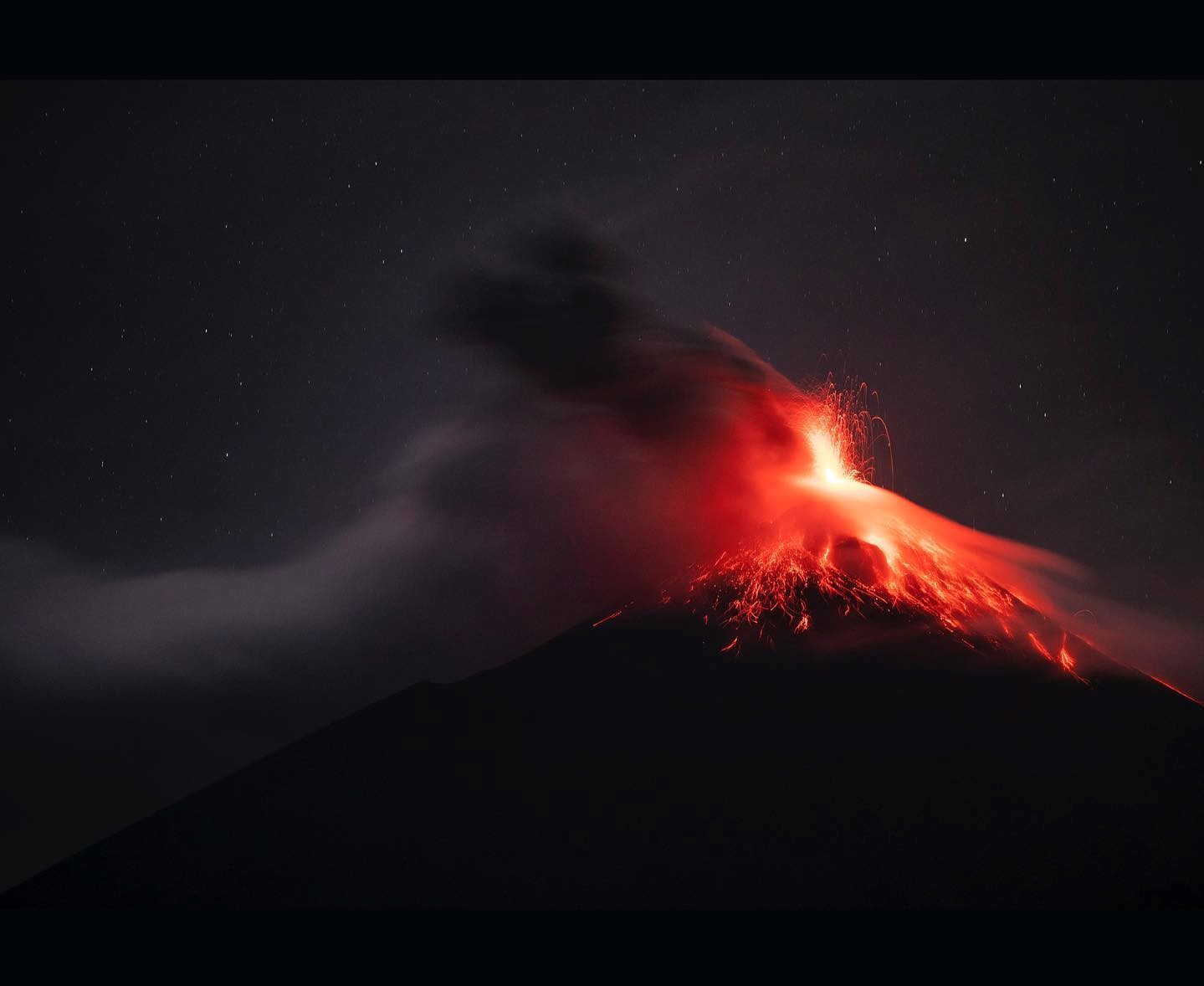
Some explosions were accompanied by rumbling sounds, shock waves, and brief noises similar to those of locomotives, associated with the continuous expulsion of gas. Incandescent glows, linked to small avalanches, were observed up to 200 m below the crater. In addition, incandescent material fell back around the crater, flowing towards the ravines of Ceniza, Taniluyá, Seca, Santa Teresa, Trinidad, and Las Lajas, sometimes reaching the tree line.
Source : Insivumeh.
Photo : Diego Rizzo