January 24 , 2026.
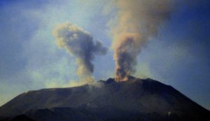
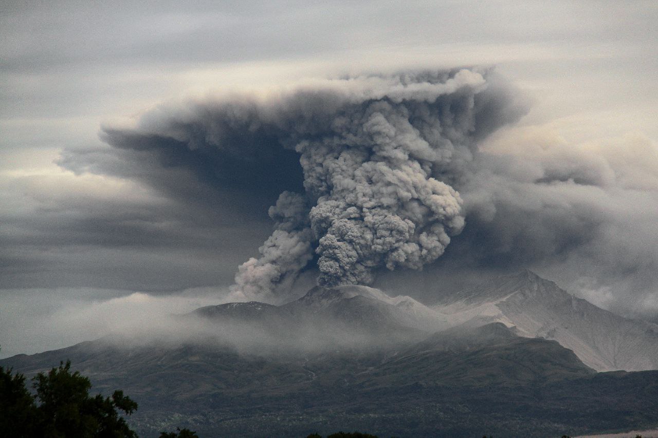
Kamchatka , Sheveluch :
KVERT VOLCANIC ACTIVITY NOTICE (VAN)
Issued: January 23 , 2026
Volcano: Sheveluch (CAVW #300270)
Current aviation colour code: RED
Previous aviation colour code: orange
Source: KVERT
Notice Number: 2026-05
Volcano Location: N 56 deg 38 min E 161 deg 19 min
Area: Kamchatka, Russia
Summit Elevation: 3283 m (10768.24 ft), the dome elevation ~2500 m (8200 ft)
Volcanic Activity Summary:
The explosions sent ash up to 10 km a.s.l., and ash cloud move for 50 km to the northeast of the volcano.
The explosive-extrusive eruption of the volcano continues. The danger of ash explosions up to 12 km (39,400 ft) a.s.l. remains. Ongoing activity could affect international and low-flying aircraft.
Volcanic cloud height:
10000 m (32800 ft) AMSL Time and method of ash plume/cloud height determination: 20260123/0730Z – Himawari-9 14m15
Other volcanic cloud information:
Distance of ash plume/cloud of the volcano: 50 km (31 mi)
Direction of drift of ash plume/cloud of the volcano: NE / azimuth 38 deg
Time and method of ash plume/cloud determination: 20260123/0730Z – Himawari-9 14m15
Start time of explosion and how determined: 20260123/0719Z – Satellite data
KVERT VOLCANIC ACTIVITY NOTICE (VAN)
Issued: January 23 ,2026
Volcano: Sheveluch (CAVW #300270)
Current aviation colour code: ORANGE
Previous aviation colour code: red
Volcanic Activity Summary:
No new ash explosions have been observed on the volcano Sheveluch at now, but a large ash cloud at altitude of 9.5 km a.s.l. continues to move to the northeast of the volcano. At 09:30 UTC on 23 January, 2025, the ash cloud edge was at a distance of 322 km at an azimuth of 32 from the volcano.
The explosive-extrusive eruption of the volcano continues. The danger of ash explosions up to 12 km (39,400 ft) a.s.l. remains. Ongoing activity could affect international and low-flying aircraft.
Source : Kvert.
Photo : Viktor Frolov ( archive)
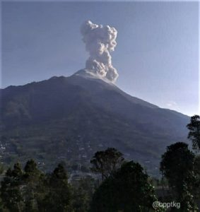
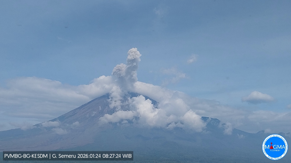
Indonesia , Semeru :
Mount Semeru erupted on Saturday, January 24, 2026, at 8:25 a.m. WIB. An ash column was observed approximately 900 meters above the summit (at an altitude of about 4,576 meters). This ash column, white to gray in color, was of moderate intensity and drifted northeast. At the time of writing, the eruption was still ongoing.
Seismic Observations
21 eruption earthquakes with amplitudes between 12 and 22 mm and durations of 91 to 132 seconds.
One distant tectonic earthquake with an amplitude of 8 mm and a duration of 69 seconds.
Recommendations
1. All activity is prohibited in the southeast sector of Besuk Kobokan, within 13 km of the summit (epicenter of the eruption). Beyond this distance, the public is advised to refrain from any activity within 500 meters of the Besuk Kobokan shoreline due to the risk of pyroclastic flows and lava flows extending up to 17 km from the summit.
2. All activity is prohibited within a 5 km radius of the crater/summit of Mount Semeru due to the risk of ejection of incandescent rocks.
Source et photo : Magma Indonésie .
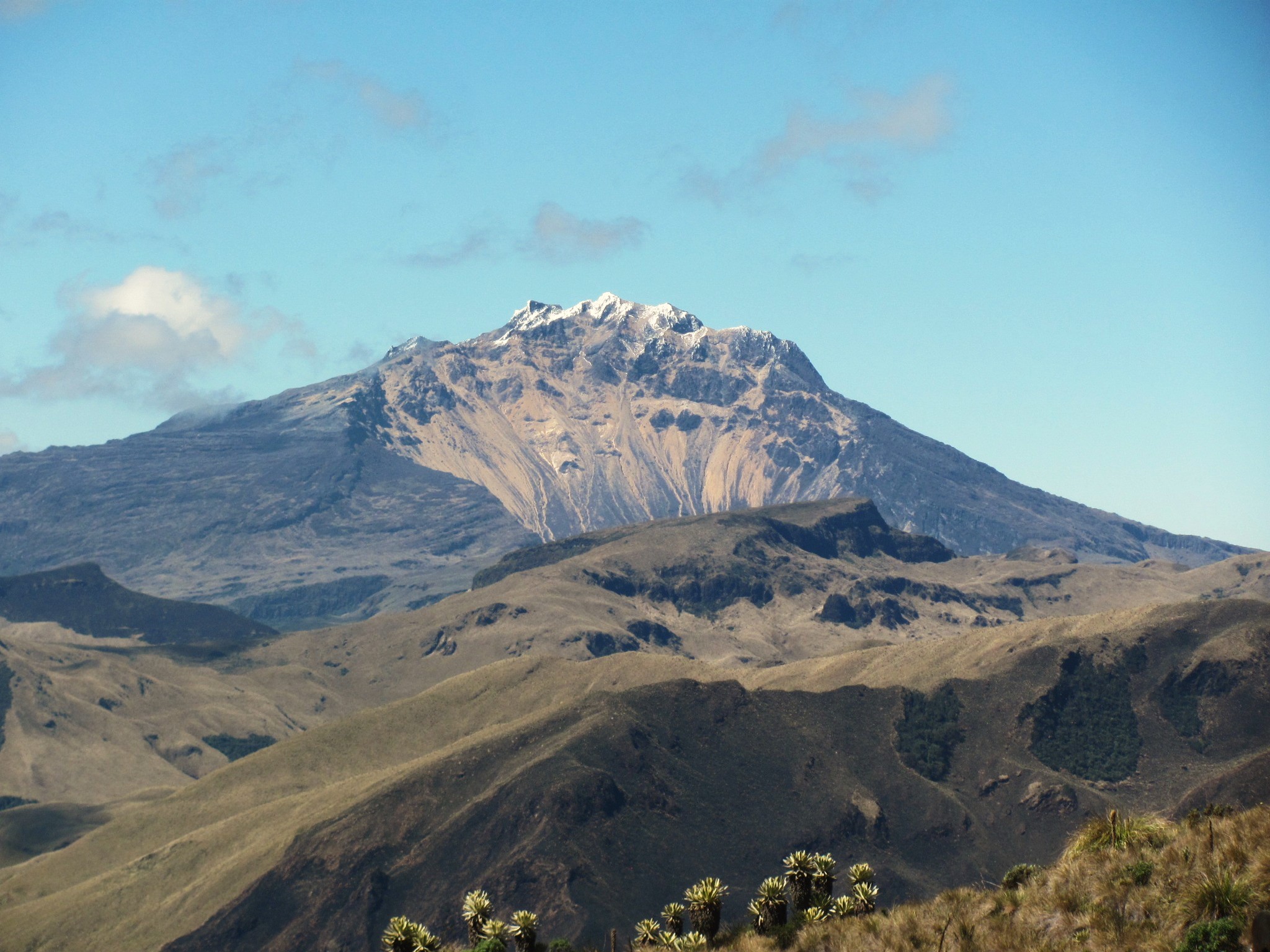
Colombia , Chiles / Cerro Negro :
San Juan de Pasto, January 20, 2026, 4:30 PM
Regarding the monitoring of activity at the Chiles-Cerro Negro Volcanic Complex (CVCCN), the Colombian Geological Survey (SGC), an agency under the Ministry of Mines and Energy, reports the following:
During the period from January 13 to 19, 2026, the main variations in monitored parameters compared to the previous week were as follows:
● A significant decrease was recorded, both in the number and energy of seismic events released. Seismicity related to fracturing of the volcanic edifice’s rock remains predominant, as does seismicity associated with fluid dynamics within the volcanoes.
● Almost all the earthquakes were located in the southwest sector of the summit of Chiles volcano, in an area approximately 3 km in diameter, at depths between 2 and 5 km below its summit (4,700 m altitude). The maximum magnitude of this seismicity was 1.8. No earthquakes were felt.
● Analysis of data from satellite sensors and ground stations continues to indicate variations associated with deformation processes in certain sectors of the volcanic zone.
Based on the assessment and correlation of monitored parameters, the SGC recommends closely monitoring its evolution through weekly bulletins and other information published via its official channels, as well as instructions from local and departmental authorities and the National Unit for Disaster Risk Management (UNGRD).
Volcanic activity remains at the yellow alert level: Active volcano with changes in the baseline behavior of monitored parameters and other manifestations.
Source et photo : SGC.
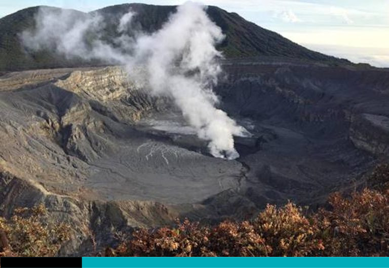
Costa Rica , Poas / Rincon de la Vieja :
Daily Volcanic Activity Report. OVSICORI-UNA, January 23, 2026. Updated: 10:58:00
Volcano: Poás
Latitude: 10.200
Longitude: -84.233
Altitude: 2,687 m
Observed Activity:
Between January 16 and 19, six small phreatic eruptions were detected. Cloud cover prevented their observation. DOAS stations detected a SO₂ flux of 190 ± 136 t/d, lower than the previous week’s (344 ± 87 t/d). The lake level exhibits considerable variability. In January 2026, it dropped by nearly 3 m and rose by about 2.5 m. This week, it rose by about 1 m.
Environmental conditions: Clear skies at the summit, southwest wind (3 m/s).
Activity level: Alert (2)
Volcano: Rincón de la Vieja
Latitude: 10.83°
Longitude: -85.324°
Altitude: 1,916 m
Observed Activity:
No eruptions or emissions were recorded this week. The last recorded eruption was on January 6. This week, DOAS stations recorded a SO₂ flux of 186 ± 102 t/d, slightly higher than the previous week (144 ± 41 t/d).
Environmental Conditions:
Cloudy skies, southwest wind (5 m/s).
Activity Level: Alert (2)
.Source : Ovsicori.
Photo : Poas / Ovsicori.
Guatemala , Santiaguito :
Atmospheric conditions: Clear skies
Wind: North
Rainfall: 0 mm
Activity:
Activity is being recorded at the Caliente dome of the Santa María-Santiaguito volcanic complex. Weak white fumaroles are rising 250 meters above the crater, and weak to moderate explosions are occurring at a rate of 1 to 2 per hour, ejecting columns of gas and ash up to an altitude of 3,400 meters. These columns are drifting west and southwest under the influence of the wind.
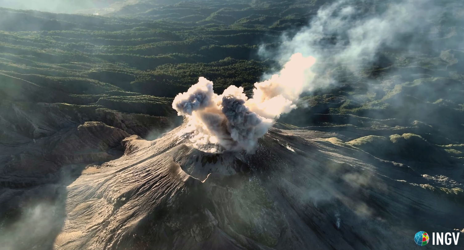
Incandescent boulders are being ejected from the slopes, and due to the wind direction, light ashfall is being reported in the mountainous areas of Monte Claro and its surroundings. Given the significant accumulation of rock material on the Caliente dome and the promontory overlooking the lava flow on its southwest flank, the formation of long-range pyroclastic flows in all directions cannot be ruled out. Therefore, it is recommended to follow the guidelines of Special Bulletin BESAN-063-2025.
Source : Insivumeh.
Photo : capture d’écran INGV Dr. Riccardo Civico