January 22 , 2026.
Alaska , Pavlof :
AVO/USGS Volcanic Activity Notice
Current Volcano Alert Level: NORMAL
Previous Volcano Alert Level: ADVISORY
Current Aviation Color Code: GREEN
Previous Aviation Color Code: YELLOW
Issued: Wednesday, January 21, 2026, 11:28 AM AKST
Source: Alaska Volcano Observatory
Notice Number: 2026/A51
Location: N 55 deg 25 min W 161 deg 53 min
Elevation: 8261 ft (2518 m)
Area: Alaska Peninsula
Volcanic Activity Summary:
The period of elevated seismic activity that prompted an increase in Pavlof’s alert level on January 14 has not been observed in the last week. No eruptive activity or unusual surface temperatures have been observed in clear satellite and web camera images. The Alaska Volcano Observatory is returning the Aviation Color Code and Alert Level to GREEN/NORMAL to reflect these background conditions. Eruptions at Pavlof often occur with little or no precursory activity, and AVO will continue to monitor the volcano using seismic, infrasound, web camera, and satellite observations.
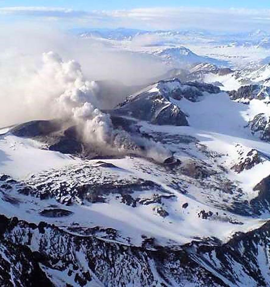
From right to left: Pavlof Sister, Pavlof, and Little Pavlof volcanoes viewed during an overflight on July 23, 2024.
Remarks:
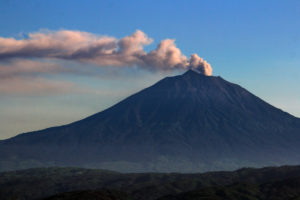
Pavlof Volcano is a snow- and ice-covered stratovolcano located on the southwestern end of the Alaska Peninsula about 953 km (592 mi) southwest of Anchorage. The volcano is about 7 km (4.4 mi) in diameter and has active vents on the north and east sides close to the summit. With over 40 historic eruptions, it is one of the most consistently active volcanoes in the Aleutian arc. Eruptive activity is generally characterized by sporadic Strombolian lava fountaining continuing for a several-month period. Ash plumes as high as 49,000 ft ASL have been generated by past eruptions of Pavlof, and during the March 2016 eruption, ash plumes as high as 40,000 feet above sea level were generated and the ash was tracked in satellite data as distant as eastern Canada. The nearest community, Cold Bay, is located 60 km (37 miles) to the southwest of Pavlof.
Source : AVO.
Photo : Loewen , Matt .
Chile / Argentina , Planchon-Peteroa :
For the period studied, volcano-tectonic (VT) seismic activity, associated with rock fracturing within the volcano, showed a decrease in the number of recorded events and the energy released compared to the previous period.
The most energetic recorded VT event had a local magnitude (ML) of 1.9 and was located 7.1 km north-northwest (NNW) of the volcanic edifice, at a depth of 20 km from the active crater.
Seismic activity associated with fluid movement within the volcano, represented by long-period (LP) earthquakes and tremors (TR), also showed a decrease in the number of recorded events and the energy released compared to the previous period. The maximum energy released during LP events, recorded via reduced displacement (DR), was 11 cm². For TR events, the maximum DR value was 12 cm². Furthermore, the energy of the continuous tremor signal, recorded from the RSAM value and associated with sustained fluid dynamics within the volcano, continued to fluctuate throughout the period, with transient increases and decreases, although a downward trend was observed. However, these values are not definitive and could change.
During this two-week period, recurring low-altitude, whitish degassing plumes were recorded at the summit of the volcano. The maximum recorded plume height did not exceed 200 m above the crater rim. Notably, no nighttime incandescence or pyroclastic material (volcanic ash) emissions were recorded during this period. Satellite data processing detected no sulfur dioxide (SO₂) anomalies in the atmosphere near the volcano during the evaluated period. However, satellite image processing detected a low-magnitude thermal anomaly (maximum radiative power [MRP] of 0.05 MW) on January 13th using the VIIRS350 satellite.
Geodetic monitoring conducted during this period revealed no significant variations related to volcanic activity. Morphological analysis, based on PlanetScope and Sentinel-2 L2A satellite imagery, showed that the emission of gas and water vapor from the Southwest Crater continues. Furthermore, no emissions or deposition of pyroclastic material were recorded during these two weeks.
Source et photo : Segemar .
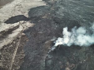
Colombia , Puracé – Los Coconucos volcanic chain :
Popayán, January 21, 2026, 8:30 a.m.
Regarding the monitoring of activity in the Los Coconucos volcanic chain, the Colombian Geological Survey (SGC), an agency under the Ministry of Mines and Energy, reports the following:
Since the publication of yesterday’s extraordinary bulletin and continuing to this day, earthquakes associated with fluid movements within the volcanic edifice have continued to occur. These are long-period (LP) tremor (TR) earthquakes. These earthquakes were located beneath the crater of the Puracé volcano, at depths of less than 1 km, and were linked to circulation processes and the release of volcanic gases into the atmosphere. One of these signals was associated with an ash emission that dispersed southwestward, following the wind direction, reaching an altitude of 300 m above the summit of the volcano.
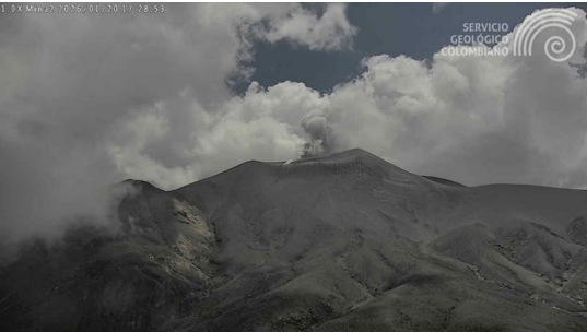
A recording from the Mina camera, located 2.2 km north of the Puracé volcano, shows an ash emission that occurred on January 20, 2026, at 12:39 PM (local time).
Sulfur dioxide (SO₂) emissions continue to be recorded, and gases continue to escape from fissures in the craters of the Curiquinga and Piocollo volcanoes, although no ash emission has been identified to date. Satellite observations indicate a decrease in the intensity of the thermal anomaly in the Puracé volcano crater. With the orange alert level remaining in place, temporary fluctuations in volcanic activity are possible, meaning that it may sometimes decrease compared to previous days or weeks. However, this does not necessarily mean that the volcano has returned to a stable level of activity. A reasonable amount of time is needed to return to the yellow alert level (greater stability) in order to assess all monitored parameters and determine any trends indicating a return to stable activity.
Given the above, the Geological Survey of Colombia (SGC) recommends staying away from the craters of the Puracé, Piocollo, and Curiquinga volcanoes, as well as their surrounding areas. We suggest you closely monitor the situation through special bulletins and information disseminated through our official channels, and follow the instructions of local and departmental authorities and the National Unit for Disaster Risk Management (UNGRD).
The volcanic activity level remains at orange alert: Volcano with significant variations in monitored parameters.
Source et photo : SGC.
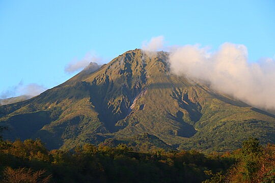
La Martinique Island , Mount Pelée :
Monthly Bulletin, Paris Institute of Earth Physics / Martinique Volcanological and Seismological Observatory, December 2025.
Volcanic Seismicity
During December 2025, the OVSM-IPGP detected 265 earthquakes of volcanic origin. None of these earthquakes were reported to have been felt by the population.
Deep Volcanic Seismicity
In December 2025, the OVSM-IPGP detected two deep, long-period earthquakes in the vicinity of Mount Pelée. These events are classified as deep if they are located at a depth greater than 10 km or, if they cannot be located, if their signal exhibits the same characteristics as that of localized deep events.
Compared to volcano-tectonic earthquakes, long-period seismic events are characterized by a longer coda enriched in low frequencies. They are generally interpreted as being generated by pressure fluctuations in magmatic fluids (magma, supercritical fluids) that circulate within the deep magmatic system.
Of the two deep, long-period earthquakes identified, only one could be located. It occurred at a depth of 25 km and its epicenter was located north of Mount Pelée, approximately 2 km from the summit. It is broadly located in the same areas as the deep earthquakes of recent months.
The magnitude of this long-period earthquake is Mlv = 0.74.
Shallow Volcanic Seismicity
257 volcano-tectonic (VT) earthquakes occurred during December 2025. This number is lower than the previous month and more than an order of magnitude lower than what was observed during September and October 2025.
Regional Seismicity
The OVSM-IPGP recorded a total of 190 regional earthquakes of tectonic origin during December 2025, of which 111 could be located. The others were either more distant or of too low a magnitude. Among these earthquakes, at least 77 were aftershocks of the magnitude Mlv = 6.6 earthquake that occurred off the coast of Guadeloupe on October 27, 2025.
Source et photo : OVSM-IPGP.
Hawaii , Kilauea :
HAWAIIAN VOLCANO OBSERVATORY DAILY UPDATE , U.S. Geological Survey
Wednesday, January 21, 2026, 9:09 AM HST (Wednesday, January 21, 2026, 19:09 UTC)
19°25’16 » N 155°17’13 » W,
Summit Elevation 4091 ft (1247 m)
Current Volcano Alert Level: WATCH
Current Aviation Color Code: ORANGE
Activity Summary:
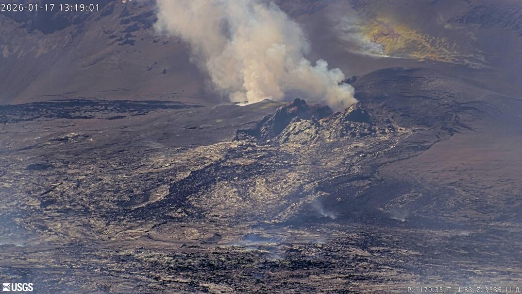
The eruption of Halemaʻumaʻu at the summit of Kīlauea is paused. The forecast for the onset of the next lava fountaining episode is between January 23 to 26, 2026 based on current inflation models. Earthquake swarm activity continues with one cluster again yesterday afternoon. No significant activity has been noted along Kīlauea’s East Rift Zone or Southwest Rift Zone.
Summit Observations:
Overnight webcam views showed consistent strong glow from north vent and intermittent glow from south vent. Constant low-level tremor continues this morning.
Earthquake swarm activity continued with one cluster yesterday afternoon starting at shortly before 5 PM HST. Locations continue to be spread fairly widely beneath the southeast part of Halemaʻumaʻu. The swarms are related to migrating magmatic pressure within the summit region but their impact on the next episode of fountaining, if any, is unknown at this time.
Since the end of episode 40, the UWD tiltmeter has recorded 14.4 microradians of inflationary tilt, with net 1.0 microradians of inflation within the past 24 hours. The late afternoon earthquake swarm was accompanied by -0.4 microrads of deflation, with inflationary trends resuming around midnight. Past pauses in inflationary tilt have resulted in a delay in the onset of the following fountaining episode.
The summit SO2 emission rate was last measured on January 14, at 1,550 tonnes per day, which is within the typical range of 1,000 to 5,000 tonnes of SO2 per day observed during previous eruptive pauses. This is considerably lower than rates observed during fountaining episodes.
Rift Zone Observations:
Rates of seismicity and ground deformation remain very low in the East Rift Zone and Southwest Rift Zone. SO2 emissions from the East Rift Zone remain below the detection limit.
Source et photo : HVO.