January 17 , 2026.
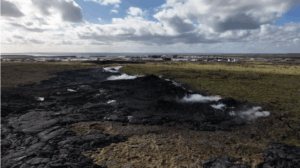
Alaska , Pavlof :
A notable increase in the rate of long-period earthquakes started on January 14 at 12:45 am AKST (09:45 UTC). This activity prompted an increase of the Aviation Color Code and Volcano Alert Level to YELLOW/ADVISORY. Clear satellite and webcam images the following days did not show any evidence for surface changes or activity. The earthquake activity has also decreased to background levels over the last two days.
Increases in this type of earthquake activity in the past have preceded eruptions, but also have ended without an eruption occurring. Eruptions at Pavlof Volcano have also occurred with little or no precursor activity.
The Alaska Volcano Observatory will continue to closely monitor Pavlof Volcano data to confirm if the period of elevated activity has ended. The volcano is monitored by local seismic and infrasound sensors, satellite data, web cameras, and regional infrasound and lightning networks
Source : AVO.
Photo : Waythomas, Chris , Alaska Volcano Observatory / U.S. Geological Survey( 2017).
Peru , Huaynaputina :
Huaynaputina Volcano: Volcanic Mudflow Damages Bridge in Quinistaquillas District. The Geophysical Institute of Peru (IGP) reports that the flow occurred this afternoon and is heading towards the Tambo River.
The Geophysical Institute of Peru (IGP) reported this afternoon a volcanic mudflow (lahar) in the El Volcán ravine, south of the Huaynaputina volcano, in the department of Moquegua. This flow damaged the infrastructure of a bridge in the district of Quinistaquillas, in the province of General Sánchez Cerro (district of Moquegua).
The flow, a cold mixture of water and volcanic sediments (ash, blocks, etc.), occurred at 3:42 PM south of Huaynaputina, in the district of Matalaque, province of General Sánchez Cerro.
The mudslide is heading towards the Tambo River, and the Quinistaquillas district and surrounding municipalities are potentially affected.
The Quinistaquillas district municipality is conducting a damage assessment and needs analysis (EDAN), while the National Emergency Operations Center (COEN) of the National Institute of Civil Protection (Indeci) is monitoring the situation.
Source : Andina.
Photo : IGP.
Chile , Laguna del Maule :
SPECIAL REPORT ON VOLCANIC ACTIVITY, January 16, 2026
The Argentine Geological and Mining Service (SEGEMAR), through its Argentine Volcanic Monitoring Observatory (OAVV), reports that today, Friday, January 16, 2026, at 02:51 local time (05:51 UTC), the volcanic monitoring stations located near the Laguna del Maule volcanic complex recorded a volcano-tectonic (VT) seismic event associated with rock fracturing within the volcanic system.
Event Information
Origin Time: 02:51 local time (05:51 UTC)
Latitude: -36.103°
Longitude: -70.509°
Depth: 9.4 km
Local Magnitude: 3.2 (ML)
OBSERVATIONS:
At the time of writing, recurring volcano-tectonic activity continues, with events of low to moderate energy.
CONCLUSIONS:
The technical alert level remains in effect, and monitoring of the volcano continues in constant communication with the Southern Andes Volcanological Observatory (OVDAS) of Chile. Any changes will be reported.
Source et photo : Segemar.
Colombia , Puracé – Los Coconucos volcanic chain :
Popayán, January 16, 2026, 8:15 a.m.
Regarding the monitoring of activity in the Los Coconucos volcanic chain, the Colombian Geological Survey (SGC), an agency under the Ministry of Mines and Energy, reports the following:
Since the publication of yesterday’s extraordinary bulletin and continuing to this day, earthquakes related to fluid movements within the volcanic edifice have continued to occur. These are long-period (LP) earthquakes associated with tremor pulses (TR). These earthquakes were located beneath the crater of the Puracé volcano, at depths of less than 1 km, and were linked to the circulation and release of volcanic gases into the atmosphere. However, visibility was reduced due to cloud cover in the area.

Low-magnitude seismicity associated with rock fracturing continues to be recorded. However, a decrease in the number of events has been observed compared to previous periods. These earthquakes were primarily located beneath the Puracé and Piocollo volcanoes, at depths between 1 and 2 km.
Sulfur dioxide (SO₂) emissions continue to be recorded, and gases continue to escape from fissures in the craters of the Curiquinga and Piocollo volcanoes, although no associated ash emissions have been identified to date. The temperature inside the Puracé volcano crater, linked to the gas emissions, continues to decrease according to satellite readings.
As long as the orange alert remains in place, temporary fluctuations in volcanic activity are possible, meaning that it may sometimes decrease compared to previous days or weeks. However, this does not necessarily imply a return to a stable level of activity. To return to the yellow alert level (greater stability), a reasonable period of time is needed to assess all monitored parameters and determine any trend indicating a return to normal.
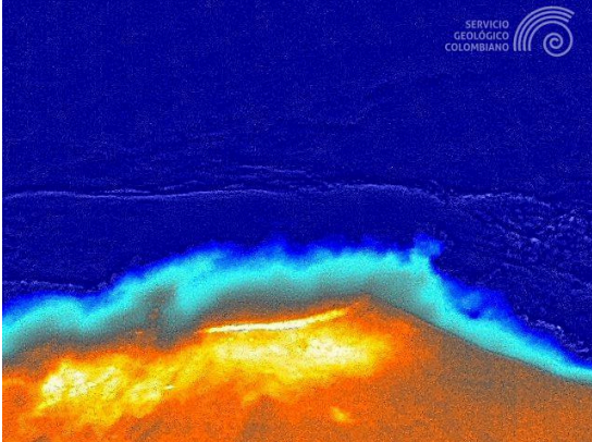
Image from the Mina infrared camera, located 2.2 km northwest of the Puracé volcano, showing warm colors (yellow to orange) related to ground surface temperature. Recorded at 8:10 PM (local time) on January 15, 2026.
Given the above, the Colombian Geological Survey (SGC) recommends avoiding the craters of the Puracé, Piocollo, and Curiquinga volcanoes, as well as their surrounding areas. We suggest closely monitoring the situation through special bulletins and information published on our official channels, as well as instructions from local and departmental authorities and the National Unit for Disaster Risk Management (UNGRD).
The volcanic activity level remains at orange alert: Volcano with significant variations in monitored parameters.
Source et photos : SGC.
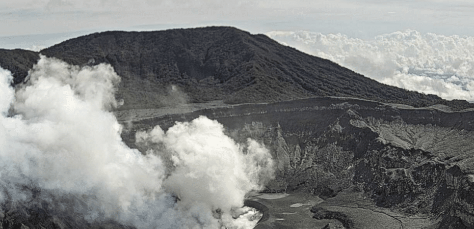
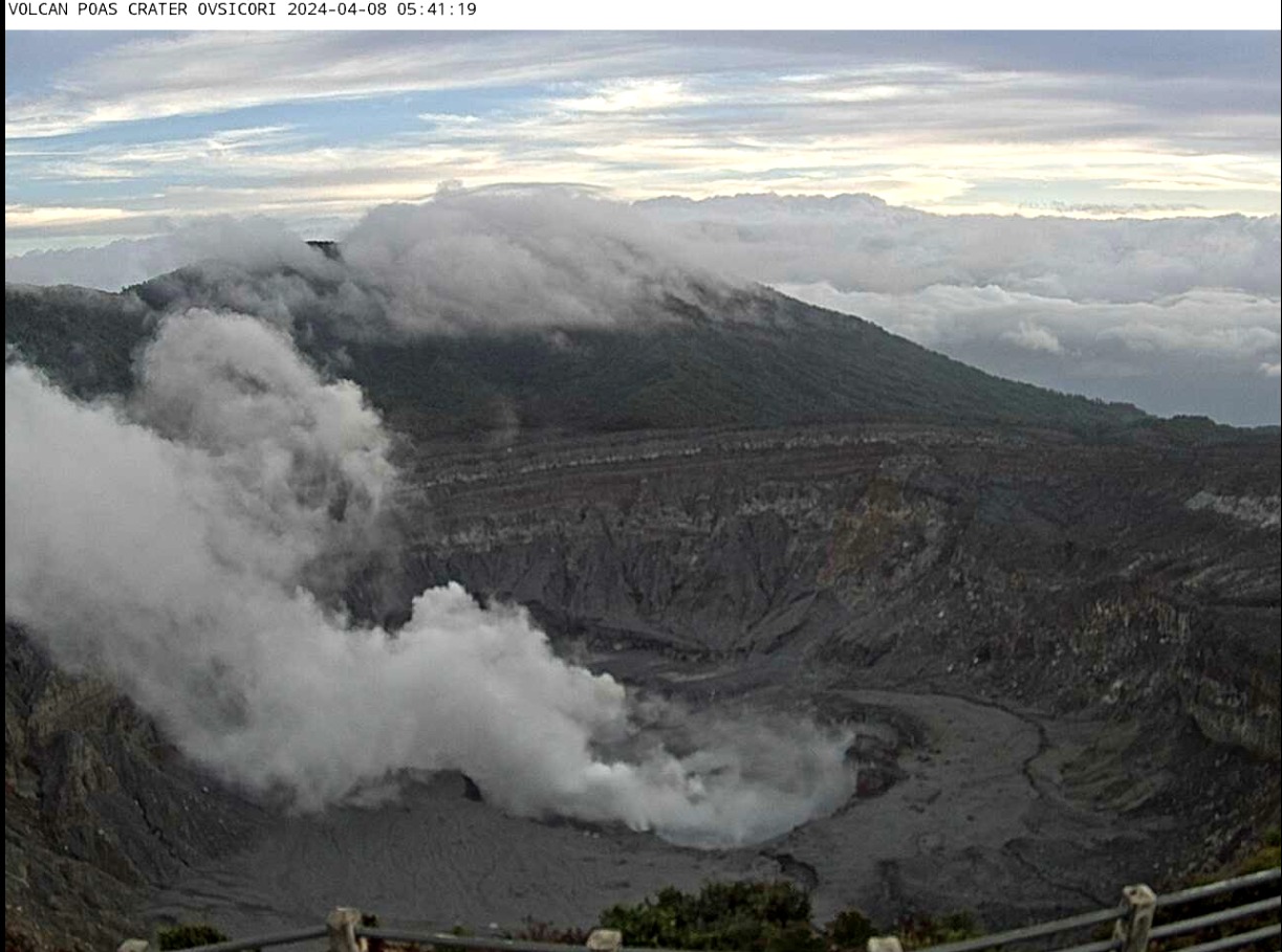
Costa Rica , Poas :
Poás Volcano Records Its First Two Eruptions of 2026
One of them generated a plume of smoke rising to over 500 meters.
The Poás Volcano recorded its first two eruptions of 2026 on January 16, the Volcanological and Seismological Observatory (OVSICORI) confirmed.
According to María Martínez, a volcanologist at OVSICORI, the first eruption occurred around 3:00 a.m., while the second was detected at 9:15 a.m.
“These are phreatic eruptions, rich in water vapor and gas, without ash. These are significant emissions of gas and steam, typical of the Poás Volcano, and do not constitute abnormal behavior,” Martínez explained.
« Due to cloud cover, we were unable to determine the height of the plume during the first eruption. » “For the second one, we estimate that it rose to about 500 meters,” she told El Observador.
She also indicated that the volcano had not experienced this type of event for several weeks, which is normal for an active volcano.
Furthermore, the volcanologist explained that the drop in the crater lake’s water level is one of the factors contributing to these eruptions.
“Since November 2025, the lake level has been continuously decreasing due to reduced rainfall and the constant influx of heat and gases from inside the volcano,” she stated.
The lower water level facilitates the release of gases into the atmosphere, which promotes these events.
“As the amount of water in the crater decreases, gases and heat can escape more freely, and that’s why these eruptions are being observed,” Martínez explained. The expert emphasized that it is impossible to accurately determine the current level of the lake, as the degassing in the crater is constant and cannot be precisely monitored. “We are in the dry season in the Poás region, and this will last until mid-May. It is therefore very likely that the water level will continue to drop and that it will dry up completely, as has already happened in some years,” he added.
Gas
Regarding gas measurements, Martínez explained that low concentrations of sulfur dioxide persist in the area of the viewpoint.
However, an analyzer located on the western rim of the crater has detected a moderate increase in this gas since January 7.
“The gas escapes more easily, and the wind pushes the plume toward the area where the sensor is located. We believe this is more of a meteorological phenomenon than a significant change in volcanic activity,” he explained.
Seismicity
Continuous seismic monitoring. Earthquakes associated with fumarolic degassing and fluid movements within the volcano are being recorded, with no abnormal variations compared to forecasts. It is worth noting that between December 3 and 4, 2025, 24 volcano-tectonic earthquakes were recorded at Poás.
These seismic events can be caused by two phenomena:
-Magma injection into the system
-Tectonic faults near the volcano
In 2025, the volcano experienced one of its most active eruptive periods.
According to volcanologist Maarten de Moor of OVSICORI, the previous year’s eruptive period began on January 5 and continued throughout the year.
“It was a very intense episode compared to recent years. The major eruptions were comparable to those of 2017,” he stated.
“Poás experiences eruptive episodes that generally last between three months and a year,” he emphasized.
Source : El Observador.
Photos : Ovsicori (archives).