February 5 , 2026.
Iceland : Reykjanes Peninsula :
Amount of magma accumulated beneath Svartsengi continues to increase
Updated 4 February
Around 21 million cubic metres have accumulated since the last eruption
The maximum magma volume that has accumulated beneath Svartsengi is 22.6 million cubic metres
Magma intrusion and volcanic eruption along the Sundhnúkur crater row are the most likely scenarios
No signs of magma accumulation elsewhere on the Reykjanes peninsula
The hazard assessment remains unchanged and has been extended until 3 March
Magma accumulation
The magma inflow rate beneath Svartsengi remains slow but steady, similar to recent weeks. According to model calculations, just under 21 million cubic meters of magma have now accumulated beneath Svartsengi since the last eruption in July 2025.
As magma accumulation continues and pressure within the system increases, the most likely scenario in the coming weeks is a magma intrusion from Svartsengi toward the Sundhnúkur crater row, which could culminate in an eruption. If an eruption occurs, it is most likely to be similar in character to previous events along the Sundhnúkur crater row.
Ground deformation and seismicity on the Reykjanes peninsula
Seismic activity in the Svartsengi area remains low.
On 28 January, a seismic swarm occurred near Lambafell, on the eastern part of the Reykjanes peninsula, with nearly 200 earthquakes recorded. In total, just over 260 earthquakes were detected in the area during the past week. The largest earthquake measured magnitude M3. This represents typical seismic activity for the area , with the last seismic swarm nearby Lambafell occurred in July 2024.
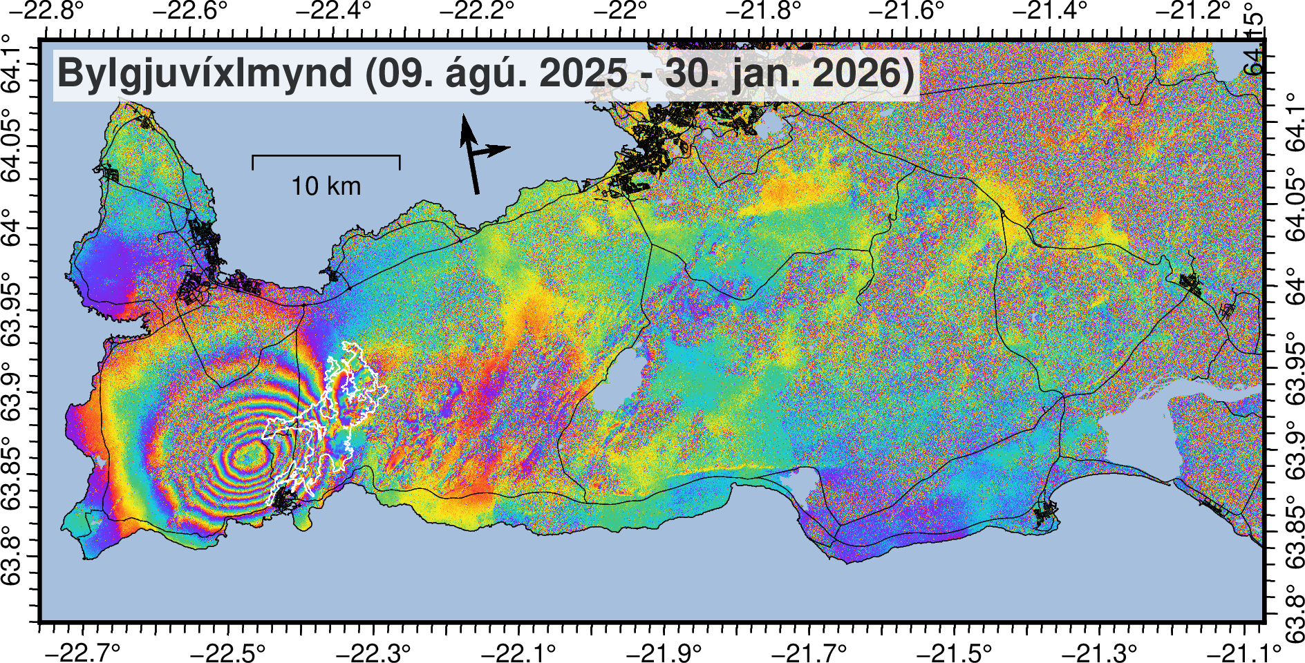
Satellite image (Bylgjuvíxlmynd; e. InSAR image) covering the period 9 August 2025–30 January 2026, showing ground uplift at Svartsengi.
An interferometric synthetic aperture radar (InSAR) image, acquired by satellite and used to detect small surface deformations by comparing images taken at different times, was recently produced. The image covers the entire Reykjanes peninsula and shows that ground deformation is only detected at Svartsengi (uplift) and nowhere else on the peninsula.
Source : IMO.
Photos : RÚV – Ragnar Visage , IMO.
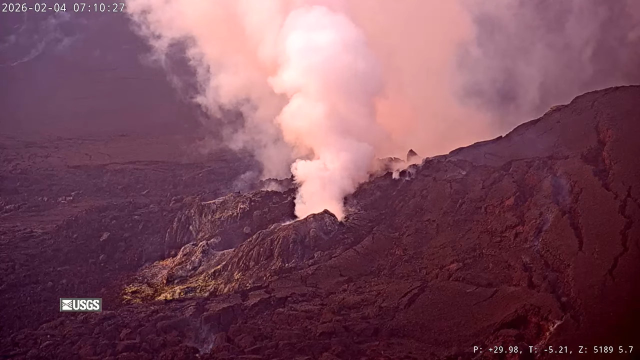
Hawaii , Kilauea :
HAWAIIAN VOLCANO OBSERVATORY DAILY UPDATE , U.S. Geological Survey
Wednesday, February 4, 2026, 9:11 AM HST (Wednesday, February 4, 2026, 19:11 UTC)
19°25’16 » N 155°17’13 » W,
Summit Elevation 4091 ft (1247 m)
Current Volcano Alert Level: WATCH
Current Aviation Color Code: ORANGE
Activity Summary:
The Halemaʻumaʻu eruption of Kīlauea is paused. Intermittent glow was visible overnight from the south vent. Seismic tremor continued over the past 24 hours. Pulses of increased tremor beneath the summit continued. Summit inflation increased over the past 24 hours to a more normal rate. The forecast for the onset of episode 42 lava fountaining is between February 11 and 16 based on current rates of summit inflation.
No significant activity has been noted along Kīlauea’s East Rift Zone or Southwest Rift Zone.
Summit Observations:
Intermittent weak to moderate glow from the south vent was visible on webcams overnight. Very little glow was visible from the north vent and may have been associated with small flames, similar to recent nights.
Seismic tremor continued over the past 24 hours. Recurring pulses of increased tremor beneath the summit occurred several times per hour. These pulses correlate with periods of increased brightness at the south vent, suggesting that gas pistoning is continuing within that conduit. Two earthquakes less than magnitude 1 were located beneath Kīlaueaʻs summit over the past 24 hours.
The Uēkahuna tiltmeter (UWD) has recorded 20.1 microradians of inflationary tilt since the end of episode 41, including 1.5 microradians of inflationary tilt in the past 24 hours. The overall rate of inflation has returned back to normal after the small dips of the previous 2 days.
The sulfur dioxide (SO2) emission rate from the summit was last measured on February 2 at 5,172 tonnes per day, which is slightly higher than the typical range of 1,000 to 5,000 tonnes of SO2 per day observed during previous eruptive pauses. This is considerably lower than rates observed during lava fountaining episodes. Areas near Kīlauea summit including Hawai’i Volcanoes National Park and nearby communities have been experiencing higher than usual levels of vog (volcanic air polution) due to ongoing light and variable winds. The National Weather Service forecast indicates calm wind becoming east southeast 5 to 8 mph today, with light and variable wind tonight.
Rift Zone Observations:
Rates of seismicity and ground deformation remain very low in the East Rift Zone and Southwest Rift Zone. SO2 emissions from the East Rift Zone remain below the detection limit.
Source et photo : HVO.
Kamchatka , Sheveluch :
KVERT VOLCANIC ACTIVITY NOTICE (VAN)
Issued: February 5 , 2026
Volcano: Sheveluch (CAVW #300270)
Current aviation colour code: RED
Previous aviation colour code: red
Source: KVERT
Notice Number: 2026-17
Volcano Location: N 56 deg 38 min E 161 deg 19 min
Area: Kamchatka, Russia
Summit Elevation: 3283 m (10768.24 ft), the dome elevation ~2500 m (8200 ft)
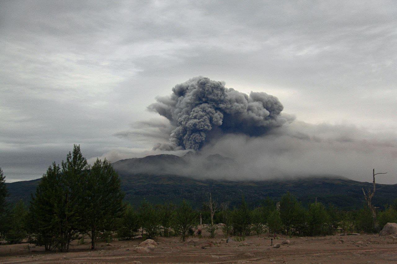
Volcanic Activity Summary:
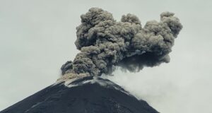
An explosive-extrusive eruption of the volcano continues. Ash plume from the explosion on 00:20 UTC moved 165 km to the north-west from volcano.
Ongoing activity could affect international and low-flying aircraft.
Volcanic cloud height:
9000 m (29520 ft) AMSL Time and method of ash plume/cloud height determination: 20260205/0300Z – Himawari-9 14m15
Other volcanic cloud information:
Distance of ash plume/cloud of the volcano: 165 km (103 mi)
Direction of drift of ash plume/cloud of the volcano: NW / azimuth 311 deg
Time and method of ash plume/cloud determination: 20260205/0300Z – Himawari-9 14m15
Start time of explosion and how determined: 20260205/0020Z – Satellite data
Duration of explosion: ~ 1 hr
Source : Kvert.
Photo : Viktor Frolov , Institut de volcanologie et de sismologie DVO RAN, @IViS_DVO_RAN ( archive).
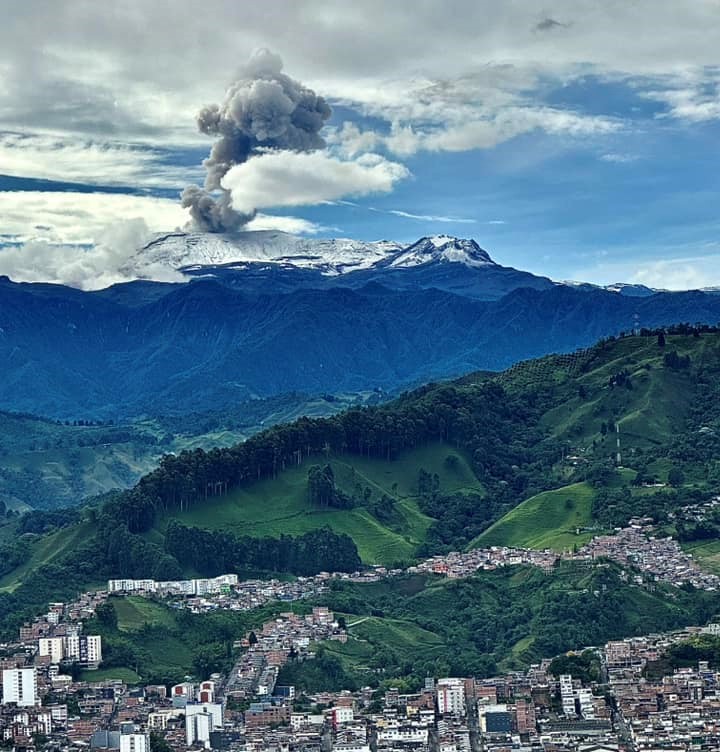
Colombia , Nevado del Ruiz :
Manizales, February 3, 2026, 5:40 PM
Regarding the monitoring of activity at the Nevado del Ruiz volcano, the Colombian Geological Survey (SGC), an agency under the Ministry of Mines and Energy, reports the following:
During the week of January 27 to February 2, 2026, the volcano continued to exhibit unstable behavior. The main variations in the monitored parameters compared to the previous week are as follows:
– Seismic activity associated with rock fracturing within the volcanic edifice increased slightly, both in the number of recorded earthquakes and in the seismic energy released. The earthquakes were primarily located in the Arenas crater and on the north-northwest flank, and to a lesser extent on the other flanks of the volcano, at distances generally less than 6 km from the crater and up to 10 km from it.
The depth of the earthquakes varied from less than 2 km to 7 km. The maximum recorded magnitude was 2.8, corresponding to the earthquake recorded on January 30 at 20:18, located 10 km northwest of the crater, at a depth of 6 km from the summit of the volcano.
– Seismicity associated with fluid dynamics in volcanic conduits, linked to short-duration signals, maintained similar values in terms of the number of recorded earthquakes and decreased slightly in terms of seismic energy released. Energy levels for this type of signal were low to occasionally moderate. Similarly, the recording of long-duration signals continued, with low energy values, generally lower than those recorded the previous week. No ash emissions associated with the aforementioned signals were confirmed, either by observations from cameras (conventional or thermographic) used to monitor the volcano, or by reports from the population in the volcanic zone.
The emission of water vapor and volcanic gases, primarily sulfur dioxide (SO₂), into the atmosphere continued through the Arenas crater. Estimates of daily SO₂ fluxes showed variability, with low values and levels similar to those of the previous week. These low values are partly due to wind direction and speed, which did not favor measurement conditions at the stations. Additional satellite monitoring also revealed low levels of SO₂ emissions.
The vertical height of the gas, steam, or ash column remained mostly between 300 and 500 m above the volcano’s summit, occasionally reaching a maximum of 600 m. The column’s dispersion direction varied toward different flanks of the volcano, with a predominance toward the northwest and west-northwest flanks.
Thermal anomalies at the bottom of the Arenas crater showed low values. Satellite monitoring remained limited by the thick cloud cover in the volcanic area.
Source : SGC.
Photo : Alex Jimenez Matiz.
La Réunion Island , Piton de la Fournaise :
Monthly Bulletin, Paris Institute of Earth Physics / Piton de la Fournaise Volcanological Observatory, January 2026.
Latitude: 21.244°S
Longitude: 55.708°E
Summit Altitude: 2632 m.
Comments
In January 2026, the OVPF-IPGP recorded the following at the Piton de la Fournaise massif:
• 2640 shallow volcano-tectonic earthquakes (0.2 to 1.5 km above sea level), mostly beneath the Bory and Dolomieu summit craters;
• 267 deep earthquakes (below sea level);
• 361 long-period earthquakes;
• 562 rockfalls.
Volcano-tectonic activity beneath Piton de la Fournaise in January 2026 was marked by two seismic crises:
– January 1st from 00:45 UTC to 1:50 UTC,
– January 18th from 12:34 UTC to 15:45 UTC.
Shallow volcano-tectonic earthquakes were primarily concentrated during these two seismic crises, which together accounted for approximately 60% of the earthquakes observed in January 2026. These « seismic swarms » are interpreted as markers of shallow magmatic injections, reflecting magma transfers from the shallow reservoir to the surface.
The seismic crisis of January 1st was located beneath the summit, along the southern edge of the annular fault, a structure inherited from the collapses of the summit craters and which typically concentrates a large part of the seismicity of Piton de la Fournaise. The location of the earthquakes observed during this crisis suggests the location of a magmatic intrusion in this sector of the volcano.
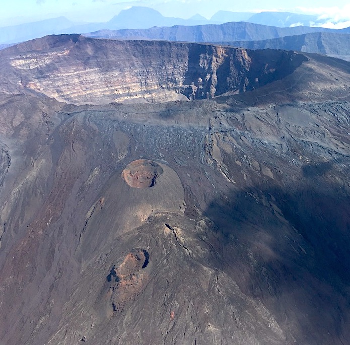
Furthermore, 562 rockfalls were detected during the month, primarily in the Dolomieu crater, at the Enclos Fouqué and Cassé de la Rivière de l’Est crater walls, as well as on recently formed lava flows. This type of gravitational activity is common at Piton de la Fournaise.
Summary
The reactivation of the shallow magmatic system of Piton de la Fournaise, observed since the end of November 2025, continued in January 2026. This pressurization triggered the seismic crisis of January 1, 2026, linked to an injection of magma from the shallow reservoir towards the surface, but which did not reach the surface (this is known as a magmatic intrusion).
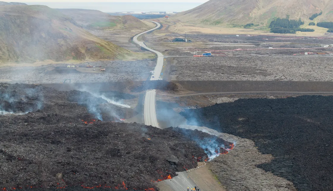
Following this intrusion, seismic activity remained sustained and inflation of the volcano continued until January 18, 2026, when a new seismic crisis led to the first observed eruption of Piton de la Fournaise since the one in July-August 2023.
The eruption began on January 18, 2026, at 15:45 UTC and ended on January 20, 2026, at 01:00 UTC, for a total duration of approximately 33 hours. Following the eruption, seismic activity remained present and inflation of the summit area persisted, indicating continued pressurization of the volcano’s shallow magma system.
It should be noted that this pressurization process of the shallow reservoir can last from several days to several weeks—or even several months—before the reservoir roof ruptures, resulting in magma being injected towards the surface and potentially leading to an eruption, but it can also stop without resulting—in the short term—in an eruption.
Source et photo : OVPF.