February 25 , 2026.
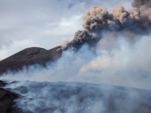
Italy , Stromboli :
WEEKLY BULLETIN, February 16, 2026 to February 22, 2026. (Publication date: February 24, 2026)
ACTIVITY SUMMARY
Based on monitoring data, the following points should be noted:
1) VOLCANOLOGICAL OBSERVATIONS: During the reporting period, ordinary Strombolian-type eruptive activity was observed, with unusual effusive activity due to lava overflows from the North Crater area. The total hourly frequency of explosions fluctuated between average (14 events/hour) and high (21 events/hour). Intensity was primarily low to medium in both crater areas, North and South-Central.
2) SEISMOLOGY: Monitored seismic parameters did not show significant variations.
3) GROUND DEFORMATION: The GNSS monitoring network showed no significant variations. The tilt network is affected by technical issues.
4) GEOCCHEMISTRY: Average SO₂ flux.
High CO₂ flux from the ground in the Pizzo area (STR02).
C/S ratio in the pen: average.
Dissolved helium isotope ratio (R/Ra) in the thermal aquifer: no update. Last data: December 2, 2025 (high value: 4.44).
High CO₂ flux from the ground in the San Bartolo area.
5) SATELLITE OBSERVATIONS: Satellite-observed thermal activity in the summit area was generally moderate, consistent with the eruptive event of February 20, 2026.
VOLCANOLOGICAL OBSERVATIONS
During the observation period, Stromboli’s eruptive activity was characterized by analyzing images recorded by the INGV-OE monitoring cameras located at an altitude of 190 m (SCT-SCV) and at Punta dei Corvi (SPCT). The explosive activity was primarily due to five eruptive vents located in the North Crater area and at least two vents located in the Central-South Crater area.
Due to heavy cloud cover on February 16, the crater terrace was not visible for a sufficient number of hours to accurately describe the eruptive activity. On February 20, 2026, an effusive eruption occurred in the North Crater area.
Observations of explosive activity captured by surveillance cameras
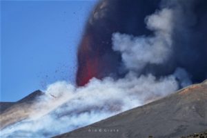
In the North Crater (N) area, five active vents were observed: two in sector N1 and three in sector N2. These vents produced low-intensity explosive activity (eruptive products reached a height of less than 80 m) and medium-intensity explosive activity (product height between 80 and 150 m).
The eruptive products were mainly composed of coarse material (bombs and lapilli). The average frequency of explosions ranged from 13 to 20 events per hour.
In the Central-South Crater (CS) area, two main vents were observed. They produced low- to medium-intensity explosions of fine material mixed with coarse material. The average frequency of explosions ranged from less than 1 to 5 events per hour.
Effusive Event of February 20, 2026
On the evening of February 20, effusive activity occurred in the N2 sector of the northern zone of the crater.
The event began at 18:10 UTC from a two-point eruptive fissure located at the base of the southernmost eruptive cone in the N2 sector, overlooking the Sciara del Fuoco. This activity produced two lava flows that remained confined throughout the event, extending for several hundred meters into the upper part of the Sciara. The phenomenon ended on February 21 at 08:00 UTC. The lava flow advanced, splitting into two arms, extending for approximately 100 m and reaching an altitude of 670 m, covering an area of 662 m².
Source : INGV.
Photo : Stromboli stati d’animo / Sebastiano Cannavo .
La Réunion Island , Piton de la Fournaise :
Press release from the Paris Institute of Earth Physics / Piton de la Fournaise Volcanological Observatory, February 25, 2026 – 11:15 a.m. local time – 7:15 a.m. UTC
Eruption in progress
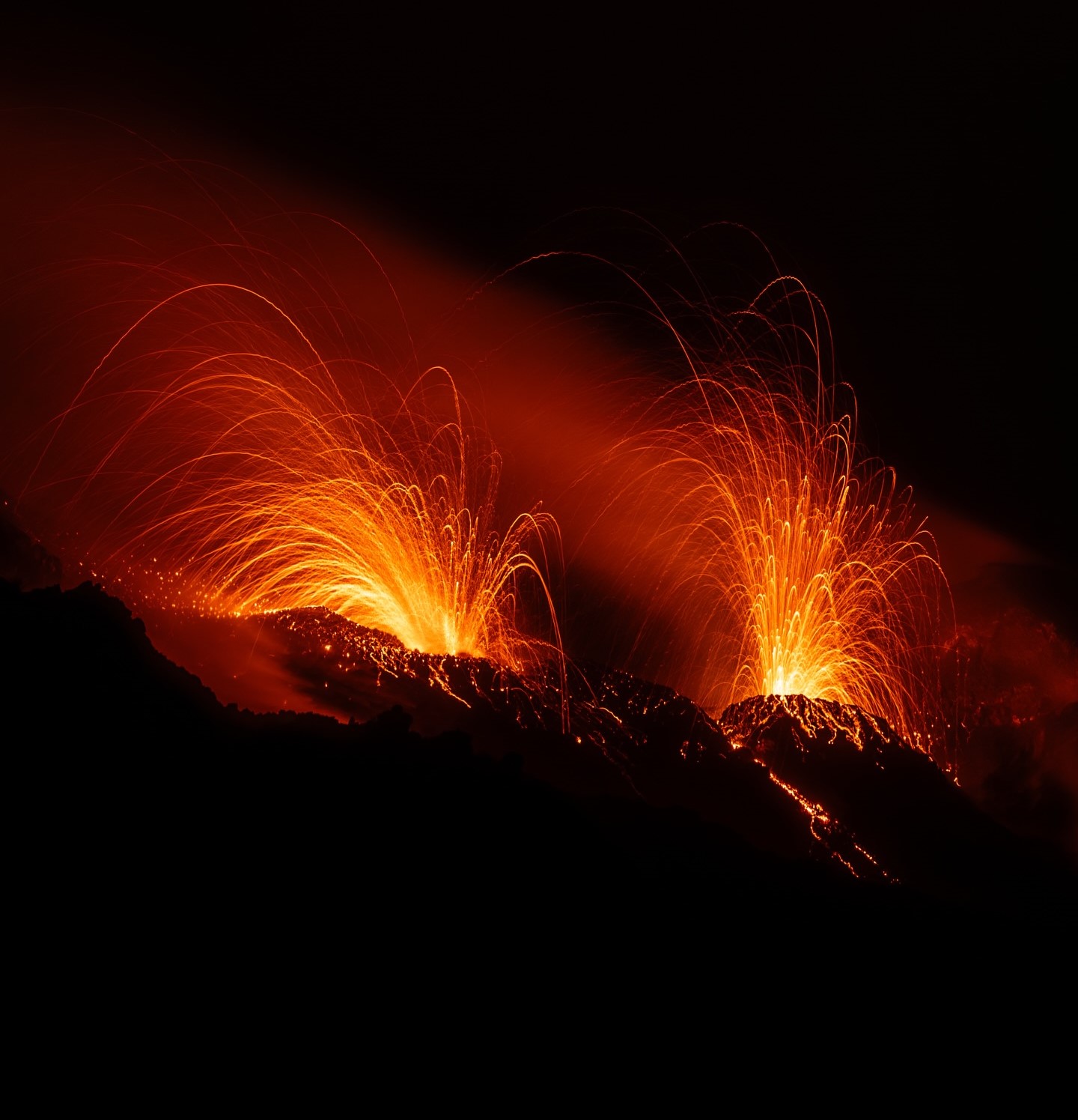
The eruption that began on February 13, 2026, shortly after 10:00 a.m. (local time), at Piton de la Fournaise continues.
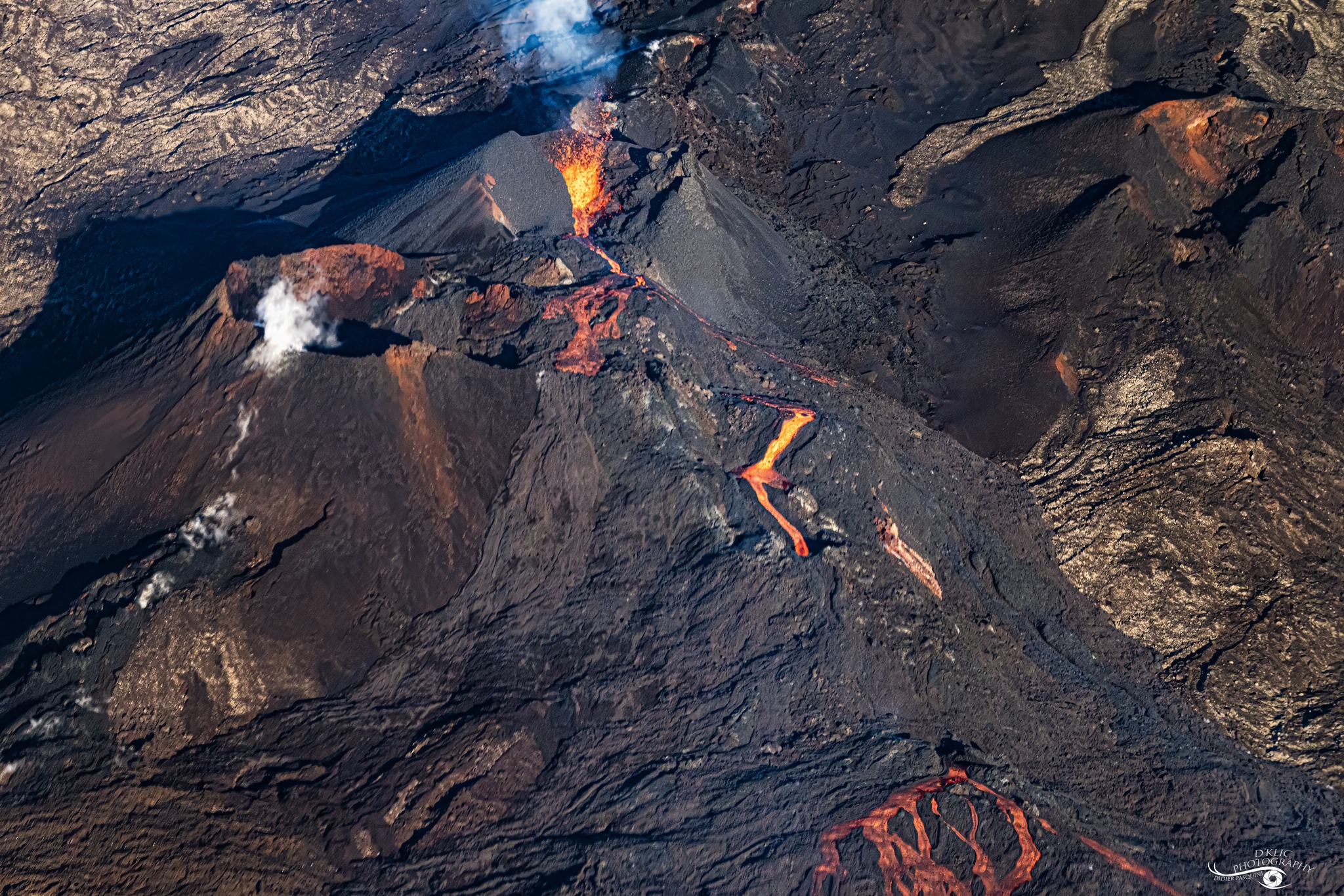
Only one eruptive site remains active on the south-southeast flank of the volcano, with fountains still visible from Piton de Bert. A cone is forming through the accumulation of lava ejecta. This cone is gradually closing, while lava tube activity is developing downstream of the cone.
The lava flow front remains stationary in the lower part of the Grandes Pentes, approximately 2.6 km from the road and at an altitude of 660 m. The active parts of the lava flow remain concentrated near the eruptive site, before the Grandes Pentes fault, where the lava field widens and thickens.
The decrease in summit seismicity is confirmed: no summit earthquakes have been observed since February 22. A decrease in the number of rockfalls has also been noted.
Surface deformations observed since the first days of the eruption indicated deflation of the summit area due to the rapid emptying of the shallow magma reservoir feeding the eruptive site (a reservoir located approximately 1.5–2 km below the summit). This phase of rapid deflation is now over. At this stage, GNSS network data show no significant trends.
The eruptive tremor (an indicator of lava and gas emissions at the surface) remains relatively stable and of low amplitude.
Since yesterday, a few amplitude peaks have been observed approximately every 6 hours, likely associated with variations in surface activity (variability in degassing) or with cycles of opening and closing the eruptive cone.
Surface flow rates, estimated from satellite data via the HOTVOLC (OPGC – Clermont-Auvergne University) and MIROVA (University of Turin) platforms, have indicated values between 1 and 9 m³/sec over the past 24 hours. It should be noted that depending on cloud cover, these estimates can change rapidly and become zero in the event of total cloud cover.
Summary
The current absence of renewed inflation of the edifice, seismic activity, and the relatively low levels of tremor and eruptive flow suggest that a balance has been established between the supply to the shallow reservoir and the volumes emitted at the eruptive site.
These observations reduce the short-term probability of a new fissure opening. However, the observatory remains vigilant. In the past, eruptive fissures have opened during eruptions without warning signals, such as in August 1998, July 1999, October 1999, December 2006, and March 2019. Indeed, the propagation of magma at shallow depths can occur aseismically, particularly when the magma has already been degassed.
Alert Level 2.1
Source : OVPF/IPGP.
Photo : D’Klic PHOTO / Didier Pasquini / FB.
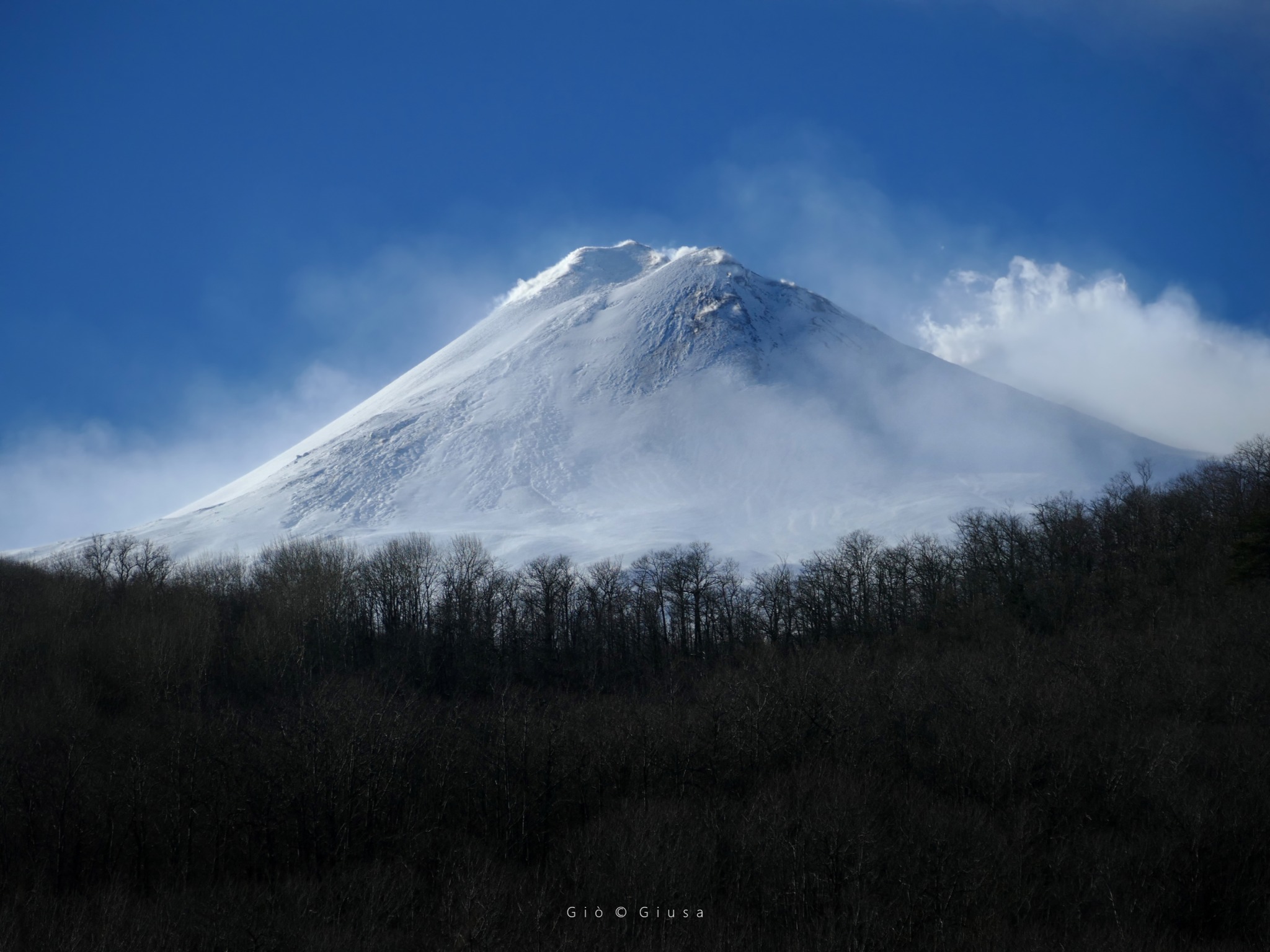
Italy / Sicily , Etna :
WEEKLY BULLETIN, February 16, 2026 to February 22, 2026. (Publication date: February 24, 2026)
ACTIVITY SUMMARY
Based on monitoring data, the following points should be noted:
1) VOLCANOLOGICAL OBSERVATIONS: Degassing at a constant rate and of varying intensity at the summit craters.
2) SEISMOLOGY: No seismic activity related to fracturing (Ml ≥ 2.0); tremor amplitude remained mainly at medium levels.
3) INFRASOUND: Low infrasound activity.
4) GROUND DEFORMATION: Ground deformation monitoring networks did not show significant variations during the week.
5) GEOCHEMISTRY: SO₂ flux at a medium level.
CO₂ flux from the ground (EtnaGas Network): average values.
Partial pressure of dissolved CO₂ in groundwater (EtnaWater Network): no update.
Helium isotope ratio at peripheral sites: average values (latest data: January 28, 2026).
6) SATELLITE OBSERVATIONS: Over the past week, thermal activity observed by satellite in the summit area has generally been low.
VOLCANOLOGICAL OBSERVATIONS
During the week in question, Mount Etna’s volcanic activity was monitored through the analysis of images from the INGV – Osservatorio Etneo (INGV-OE) surveillance cameras.
Observations from the surveillance cameras were limited on some days due to adverse weather conditions that prevented observation of Etna’s summit area.
Overall, during the period under review, Etna’s activity was characterized by degassing of varying intensity and pattern at the summit craters.
Source : INGV.
Photo : Gio Giusa.
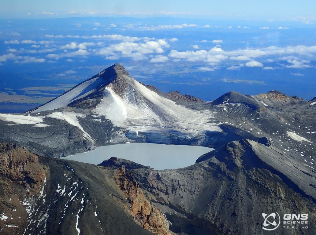
New Zealand , Ruapehu :
Update on activity at Ruapehu: Temperature of Te Wai ā-moe (Ruapehu Crater Lake) is stable. The Volcanic Alert Level remains at 1. Published: Wed Feb 25 2026 11:30 AM
The temperature of Te Wai ā-moe (Ruapehu Crater Lake) has remained relatively cool since August 2025. The current temperature is now around 18 °C. We continue to measure low to moderate volcanic sulphur dioxide (SO₂) gas emissions, and low levels of volcanic tremor. These observations are consistent with minor volcanic unrest. The Volcanic Alert Level remains at 1 and the Aviation Colour Code at Green
In late 2025, we reported that the temperature of Te Wai ā-moe had risen to about 17 °C. Following past temperature cycles, we expected the lake temperature to continue to rise. However, since then, the lake temperature has fluctuated between about 14 and 19 °C. This shows only a modest level of change, which is subtle, but not unusual compared with the last 16 years of observations. The data indicates that the flow of relatively hot fluid has been reduced over the past few months. When compared to historical measurements, this has happened in 2012-13, 2014, 2019 and 2022.
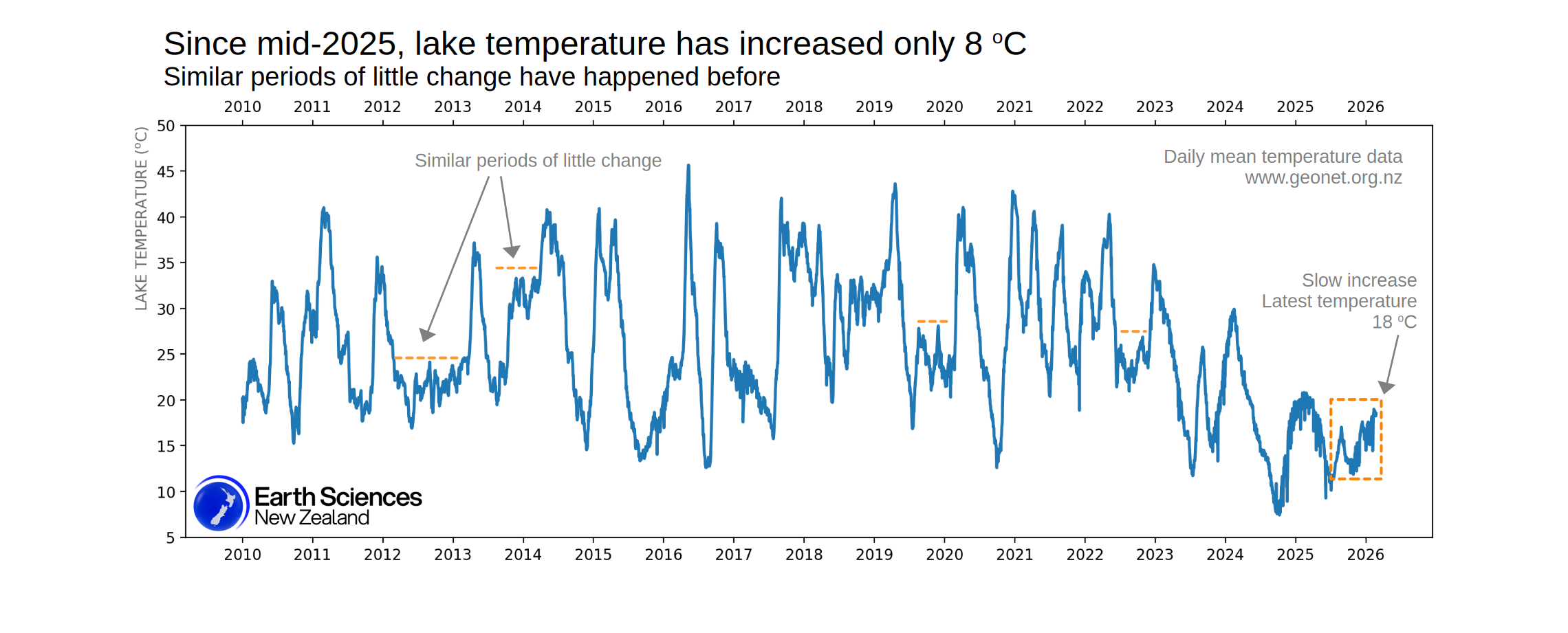
Daily mean temperature of Te Wai ā-moe (Ruapehu Crater Lake) since 2010. The steady-fluctuating lake temperature seems to be of a similar magnitude to periods in 2012-2013, 2014, 2019, and 2022 .
Despite the relatively low flow of fluid into the lake from below, we are still recording similar levels of sulphur dioxide (SO₂) gas emissions, which indicates that the hydrothermal system remains open. Volcanic tremor remains weak and when we consider all the observations, we interpret the current activity to be low-level, consistent with minor volcanic unrest. Therefore, the Volcanic Alert Level remains at 1 and the Aviation Colour Code remains Green.
More information:
Volcanic Alert Level 1 indicates the primary hazards are those expected during volcanic unrest: steam discharge, volcanic gas, earthquakes, landslides, and hydrothermal activity. While Volcanic Alert Level 1 is mostly associated with environmental hazards, potential for eruption hazards also exists and eruptions can still occur with little or no warning.
Source : Geonet / Geoff Kilgour / Duty Volcanologist
Photos : GNS Science , Geonet.
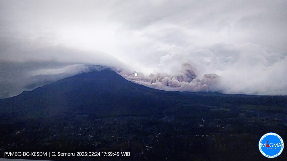
Indonesia , Semeru :
Mount Semeru has experienced an eruption on Tuesday, February 24, 2026, at 5:36 PM (Jakarta time). An ash column was observed approximately 3,000 meters above the summit (at an altitude of about 6,676 meters). This gray-brown ash column was highly concentrated and moving southeast. At the time of writing, the eruption was still ongoing.
Seismic Observations
20 eruption earthquakes with amplitudes between 10 and 22 mm and durations of 63 to 174 seconds.
An avalanche earthquake with an amplitude of 5 mm and a duration of 85 seconds.
Three emission earthquakes with an amplitude of 2 mm and a duration of 64 to 72 seconds.
One harmonic tremor with an amplitude of 2 mm and a duration of 1200 seconds.
Recommendations
1. All activity is prohibited in the southeast sector of Besuk Kobokan, within 13 km of the summit (epicenter of the eruption). Beyond this distance, the public is advised to refrain from any activity within 500 meters of the Besuk Kobokan shoreline due to the risk of pyroclastic flows and lava flows extending up to 17 km from the summit.
2. Do not carry out any activity within a 5 km radius around the crater/summit of Mount Semeru volcano due to the risk of (incandescent) rock ejection.
Source et photo : PVMBG.