February 20 , 2026.
La Réunion Island , Piton de la Fournaise :
Press release from the Paris Institute of Earth Physics / Piton de la Fournaise Volcanological Observatory, February 20, 2026 – 9:00 a.m. local time – 5:00 a.m. UTC
Eruption in progress
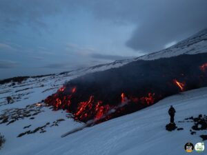
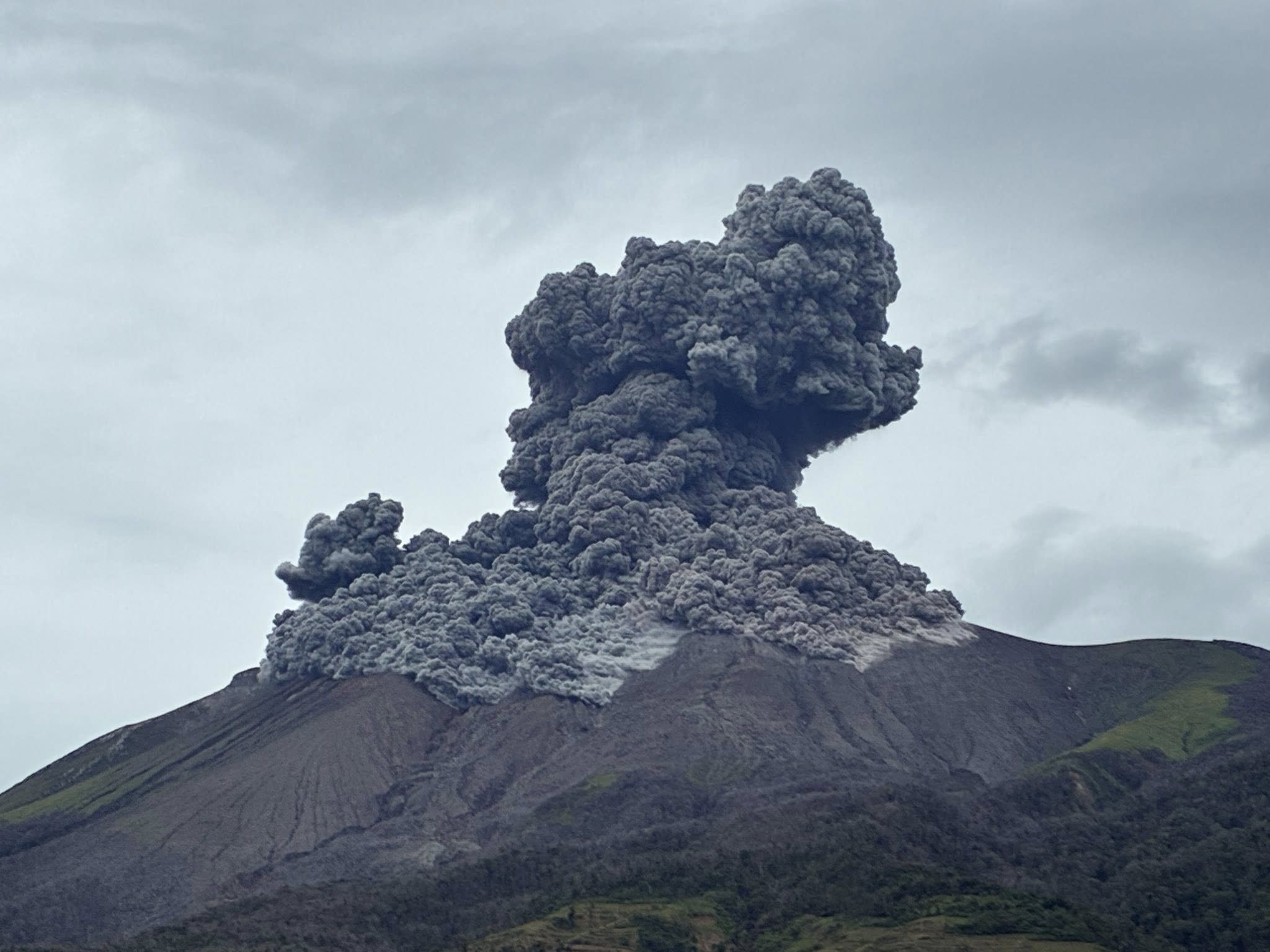
The eruption that began on February 13, 2026, shortly after 10:00 a.m. (local time), at Piton de la Fournaise continues.
Only one eruptive site remains active on the south-southeast flank of the volcano, with fountains clearly visible from Piton de Bert.
Seismicity beneath the summit continues. Since February 14, 317 shallow volcano-tectonic earthquakes have been recorded beneath the summit area at depths of between 1.6 and 2.1 km. The persistence of this seismic activity beneath the summit indicates that the magma system remains under pressure; new fissure openings remain possible.
Numerous rockfalls are still being recorded. Their number is increasing, particularly at the cone forming on the eruptive site. The intensity of the eruptive tremor (an indicator of lava and gas emissions at the surface) has remained generally stable over the last 24 hours.
Surface flow rates, estimated from satellite data via the HOTVOLC (OPGC – Clermont Auvergne University) and MIROVA (University of Turin) platforms, have shown values between 1 and 7 m³/sec over the last 24 hours. It should be noted that depending on cloud cover, these estimates can change rapidly and be zero in the event of total cloud cover. The lava flow front remains stationary in the lower part of the Grandes Pentes, approximately 2.6 km from the road and at an altitude of 660 m.
The active parts of the flow are still concentrated near the eruptive site, before the Grandes Pentes fault.
Alert level 2.1
A seismic swarm almost a week later, that began at 09h50 on 13 February, was accompanied by rapid deformation, and followed by volcanic tremor at 10h00 indicative of magma near the surface; a new eruption was visible in webcam images at around 10h06. The Alert Level was raised to 2.1 (on a 0–4 scale) and 87 hikers were evacuated by the Section Aérienne de Gendarmerie (SAG) according to the Gendarmerie de La Réunion. Three fissures that were adjacent to each other were located on the upper S and SE flanks of Dolomieu Crater, near the summit. Seismic data showed that eruptive activity was initially concentrated near the summit and then shifted towards the SSE flank.
Sources : OVPF-IPGP , GVP.
Photo : Christian Holveck / FB.
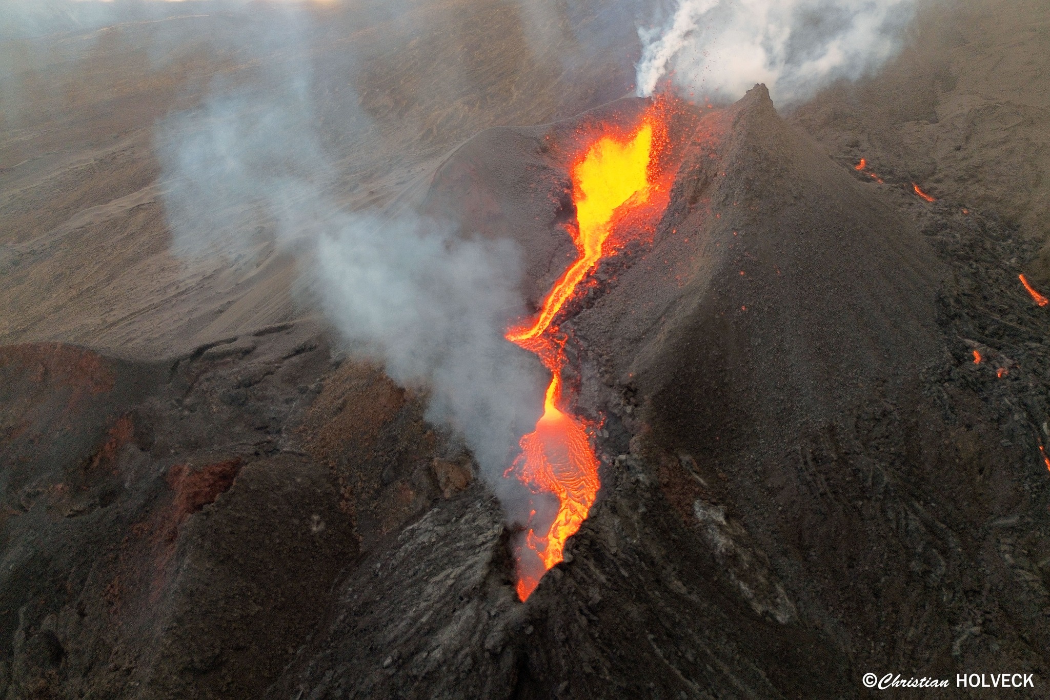
Philippines , Kanlaon :
The Philippine Institute of Volcanology and Seismology (PHIVOLCS) reported continuing eruptive activity at Kanlaon during 11-19 February. The seismic network recorded 2-24 daily volcanic earthquakes; on 13 February two periods of tremor, 15 and 17 minutes long, were also detected. Daily steam-and-gas plumes rose as high as 150 m above the summit and drifted mainly NW, W, and SW. Sulfur dioxide emissions ranged from 346 to 2,111 tonnes per day. One or two ash emissions, each 17 minutes long, occurred during 12-13 February.
A three-minute-long ash emission was recorded during 13h10-13h13 on 16 February and produced a grayish ash plume that rose 150 m above the summit and drifted SW. A two-minute-long, moderately explosive eruption at 16h39 on 19 February generated a dense, dark gray ash plume that rose 2 km above the summit and drifted SW. Pyroclastics flows traveled as far as 1 km down the upper S and SW flanks.
The Alert Level remained at 2 (on a scale of 0-5); the public was warned to stay out of the 4-km-radius Permanent Danger Zone (PDZ) and pilots were advised to avoid flying close to the summit.
Sources: Philippine Institute of Volcanology and Seismology (PHIVOLCS), GVP.
Photo : Leah Pahayahay Martinez.
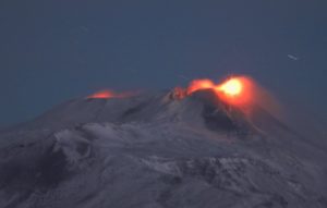
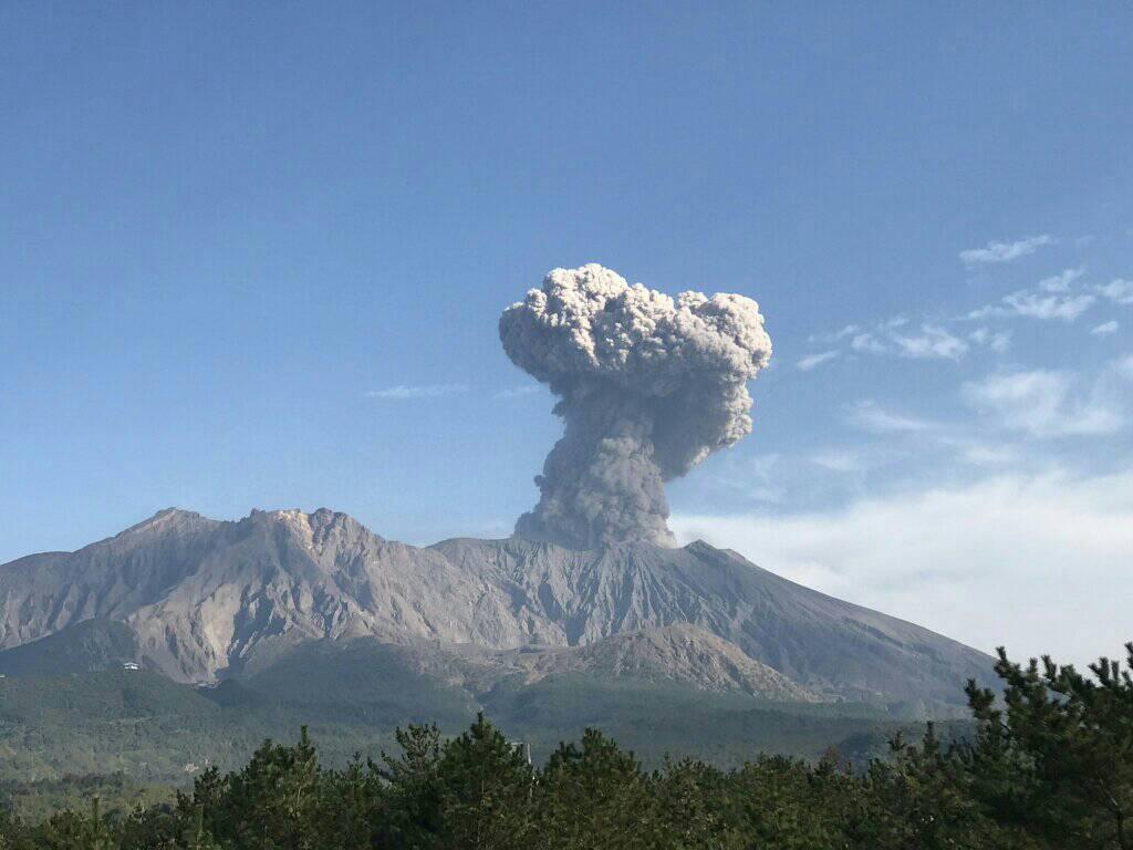
Japan , Sakurajima :
The Japan Meteorological Agency (JMA) reported ongoing eruptive activity at Minamidake Crater (Aira Caldera’s Sakurajima volcano) during 9-16 February. Crater incandescence was visible in webcam images throughout the week, and small eruptive events occasionally occurred. The Alert Level remained at 3 (on a 5-level scale), and the public was warned to be cautious within 2 km of both the Minimadake and Showa craters.
The Aira caldera in the northern half of Kagoshima Bay contains the post-caldera Sakurajima volcano, one of Japan’s most active. Eruption of the voluminous Ito pyroclastic flow accompanied formation of the 17 x 23 km caldera about 22,000 years ago. The smaller Wakamiko caldera was formed during the early Holocene in the NE corner of the caldera, along with several post-caldera cones. The construction of Sakurajima began about 13,000 years ago on the southern rim and built an island that was joined to the Osumi Peninsula during the major explosive and effusive eruption of 1914. Activity at the Kitadake summit cone ended about 4,850 years ago, after which eruptions took place at Minamidake. Frequent eruptions since the 8th century have deposited ash on the city of Kagoshima, located across Kagoshima Bay only 8 km from the summit. The largest recorded eruption took place during 1471-76.
Sources: Japan Meteorological Agency (JMA), GVP.
Photo : Rizal M.( archive).
Alaska , Great Sitkin :
The Alaska Volcano Observatory (AVO) reported that slow lava effusion continued to feed a thick flow in Great Sitkin’s summit crater during 11-18 February. Radar data on 11 February indicated that slow growth was concentrated near the vent area. Seismic activity was low during the week, with occasional small earthquakes and rockfalls detected by the seismic network. Elevated surface temperatures were identified in satellite images on most days. Weather clouds sometimes obscured satellite and webcam views.
A deposit from a small rockfall, originating on the S flank of the lava dome near the vent region, was observed in a satellite image and in a webcam image on 14 February. The deposit was about 300 m long and confined to the summit crater. Moderately elevated surface temperatures were observed at the source of the rockfall. The Volcano Alert Level remained at Watch (the third level on a four-level scale) and the Aviation Color Code remained at Orange (the third color on a four-color scale).
Source: US Geological Survey Alaska Volcano Observatory (AVO), GVP.
Photo : Loewen, Matthew AVO/USGS.
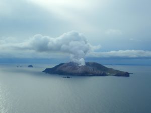
Australia , Heard Island / Big Ben :
According to the Darwin Volcanic Ash Advisory Center (VAAC) eruptive activity at Heard Island’s Big Ben volcano produced an ash plume that was identified in satellite images at 1900 on 11 February rising to 7.3 km (24,000 ft) a.s.l. and drifting NE, based on analysis by the Toulouse VAAC. Ash was not identified in a satellite image at 11h40 on 12 February. Satellite images showed a small temperature anomaly at the summit and on the very upper SW flanks on 8, 13, and 16 February. The 16 February view was mostly clear with weather clouds only obscuring parts of the lower western and southern flanks. There was a long narrow darker streak on the SW channel in visible wavelengths, possibly from cooled lava flows.

Heard Island on the Kerguelen Plateau in the southern Indian Ocean consists primarily of the emergent portion of two volcanic structures. The large glacier-covered composite basaltic-to-trachytic cone of Big Ben comprises most of the island, and the smaller Mt. Dixon lies at the NW tip of the island across a narrow isthmus. Little is known about the structure of Big Ben because of its extensive ice cover. The active Mawson Peak forms the island’s high point and lies within a 5-6 km wide caldera breached to the SW side of Big Ben. Small satellitic scoria cones are mostly located on the northern coast. Several subglacial eruptions have been reported at this isolated volcano, but observations are infrequent and additional activity may have occurred.
Sources: Darwin Volcanic Ash Advisory Centre (VAAC), Copernicus, GVP.
Photo : Auteur inconnu.