February 19 , 2026.
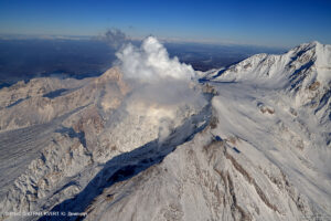
La Réunion Island , Piton de la Fournaise :
Press release from the Paris Institute of Earth Physics / Piton de la Fournaise Volcanological Observatory, February 18, 2026 – 11:00 AM local time – 7:00 AM UTC
Eruption in progress
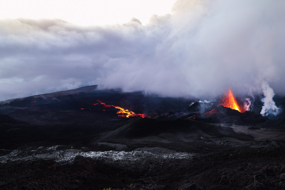
The eruption that began on February 13, 2026, shortly after 10:00 AM (local time), at Piton de la Fournaise, continues.
Only one eruptive site remains active on the south-southeast flank of the volcano, with fountains clearly visible from Piton de Bert.
The intensity of the eruptive tremor (an indicator of lava and gas emissions at the surface) has remained generally stable since yesterday. Surface flow rates, estimated from satellite data via the HOTVOLC platform (OPGC – Clermont Auvergne University), have shown values between 1 and 9 m³/sec over the past 24 hours. Note that depending on cloud cover, these estimates can vary rapidly and be zero in the event of total cloud cover.
The lava flow front remains stationary in the lower part of the Grandes Pentes ridge, approximately 2.6 km from the road and at an altitude of 660 m.
The active parts of the flow are still concentrated near the eruptive site before the Grandes Pentes ridge. The continued seismic activity beneath the summit indicates that the magma system remains under pressure; new fissure openings are still possible in the coming hours, particularly further downstream. The OVPF-IPGP (Volcanological Observatory of Piton de la Fournaise – Paris Pyrenees Institute) remains on continuous monitoring of the situation.
Two rockfalls were recorded by our seismological sensors at 8:19 a.m. and 8:29 a.m. (local time) in the eastern flank of the volcano. Poor weather conditions in the area prevented precise localization of these events.
No significant changes in the eruptive dynamics are associated with these events.
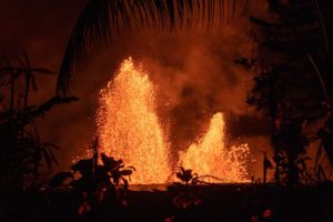
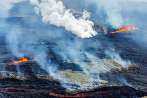
Press release from the Paris Institute of Earth Physics / Piton de la Fournaise Volcanological Observatory, February 19, 2026 – 8:45 a.m. local time – 4:45 a.m. UTC
Eruption in progress.
The eruption that began on February 13, 2026, shortly after 10:00 a.m. (local time), at Piton de la Fournaise, continues.
Only one eruptive site remains active on the south-southeast flank of the volcano, with fountains clearly visible from Piton de Bert.
Seismicity beneath the summit continues, although it is decreasing. Since February 14, 296 shallow volcano-tectonic earthquakes have been recorded beneath the summit area at depths of between 1.6 and 2.1 km. The persistence of this seismic activity beneath the summit indicates that the magma system remains under pressure; new fissure openings are still possible.
Numerous rockfalls are still being recorded. Their number is increasing, particularly at the cone forming on the eruptive site. These rockfalls were confirmed yesterday by the OVPF-IPGP teams in the field.
The intensity of the eruptive tremor (an indicator of lava and gas emissions at the surface) has remained generally stable over the last 24 hours. Surface flow rates, estimated from satellite data via the HOTVOLC (OPGC – Clermont Auvergne University) and MIROVA (University of Turin) platforms, have shown values between 2 and 8 m³/sec over the last 24 hours. It should be noted that depending on cloud cover, these estimates can change rapidly and be zero in the event of total cloud cover.
The lava flow front remains stationary in the lower part of the Grandes Pentes, approximately 2.6 km from the road and at an altitude of 660 m. The active parts of the lava flow remain concentrated near the eruptive site before the Grandes Pentes fissure.
Alert level 2-1.
Source : OVPF/IPGP.
Photos : OVPF , Eric Atoy /Paysages et volcans
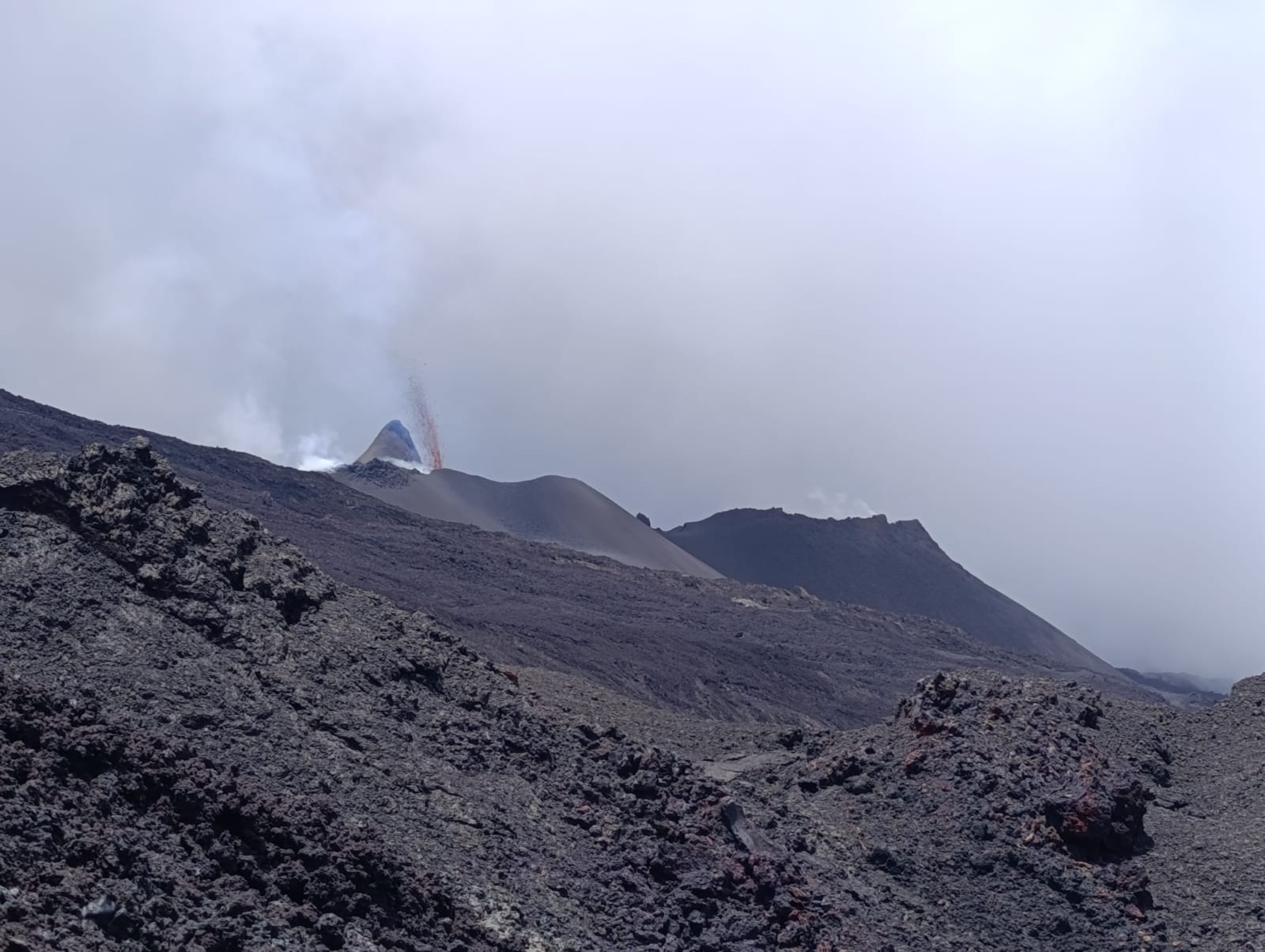
Indonesia , Marapi :
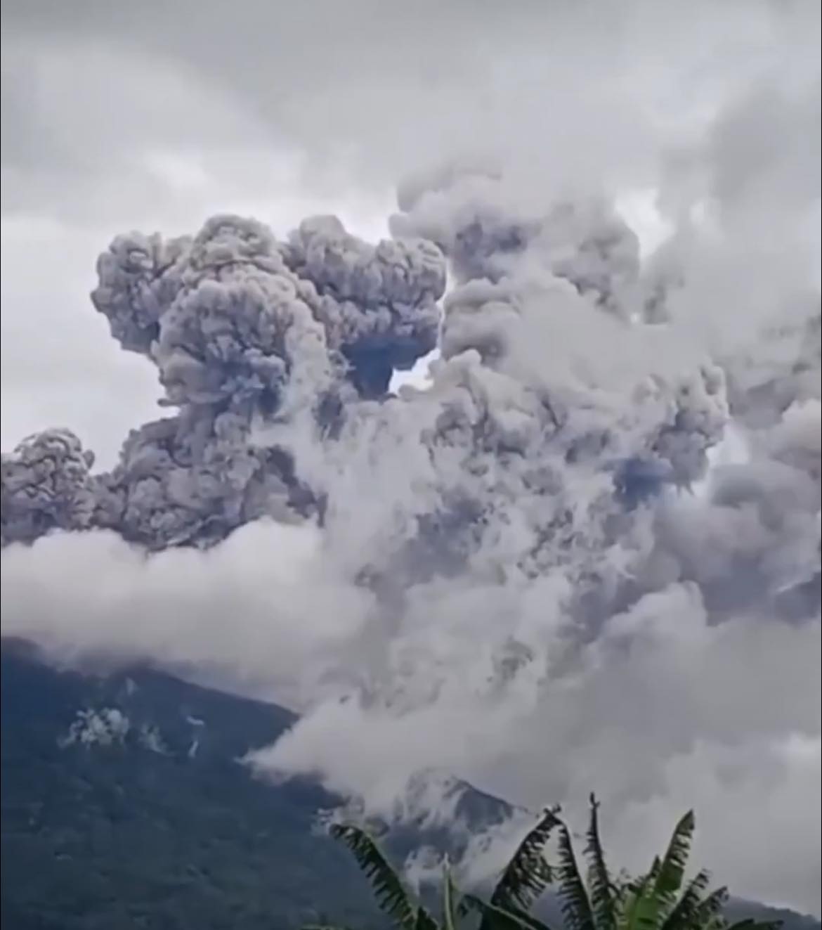
Mount Marapi erupted on Wednesday, February 18, 2026, at 10:53 AM West Indonesian Time (WIB). No visual observations were made. The eruption was recorded by a seismograph with a maximum amplitude of 30 mm and a duration of 31 seconds.
VOLCANO OBSERVATORY NOTICE FOR AVIATION – VONA
Issued : February 18 , 2026
Volcano : Marapi (261140)
Current Aviation Colour Code : ORANGE
Previous Aviation Colour Code : yellow
Source : Marapi Volcano Observatory
Notice Number : 2026MAR026
Volcano Location : S 0 deg 22 min 52 sec E 100 deg 28 min 23 sec
Area : West Sumatra, Indonesia
Summit Elevation : 9251 FT (2891 M)
Volcanic Activity Summary :
Eruption at 03h53 UTC (10h53 local).
Volcanic Cloud Height :
Ash-cloud is not observed.
Other Volcanic Cloud Information :
Ash-cloud is not observed.
Remarks :
Eruption recorded on seismogram with maximum amplitude 30 mm and maximum duration 31 second. Tremor recorded on seismogram with maximum amplitude 3.1 mm.
Source : Magma Indonésie
Photo : The Watchmen’s Earth and Space connection.
Alaska , Aniakchak :
ALASKA VOLCANO OBSERVATORY INFORMATION STATEMENT , U.S. Geological Survey
Wednesday, February 18, 2026, 11:48 AM AKST (Wednesday, February 18, 2026, 20:48 UTC)
56°54’21 » N 158°12’32 » W,
Summit Elevation 4400 ft (1341 m)
Current Volcano Alert Level: UNASSIGNED
Current Aviation Color Code: UNASSIGNED
The Aviation Color Code and Alert level remain at UNASSIGNED for Aniakchak Volcano. The status of the volcano was moved from GREEN/NORMAL to UNASSIGNED/UNASSIGNED on December 23, 2025 due to a lack of data received from Aniakchak seismic stations following a power outage at the Port Heiden Receive Facility. Some preliminary repairs to the power system have since been completed at the receive facility and the Alaska Volcano Observatory began to receive data on February 5 from the geophysical network located on Aniakchak volcano. Data acquisition remains stable since the repairs, but the status of the volcano will remain at UNASSIGNED until permanent repairs can be made to systems to insure reliable connectivity.
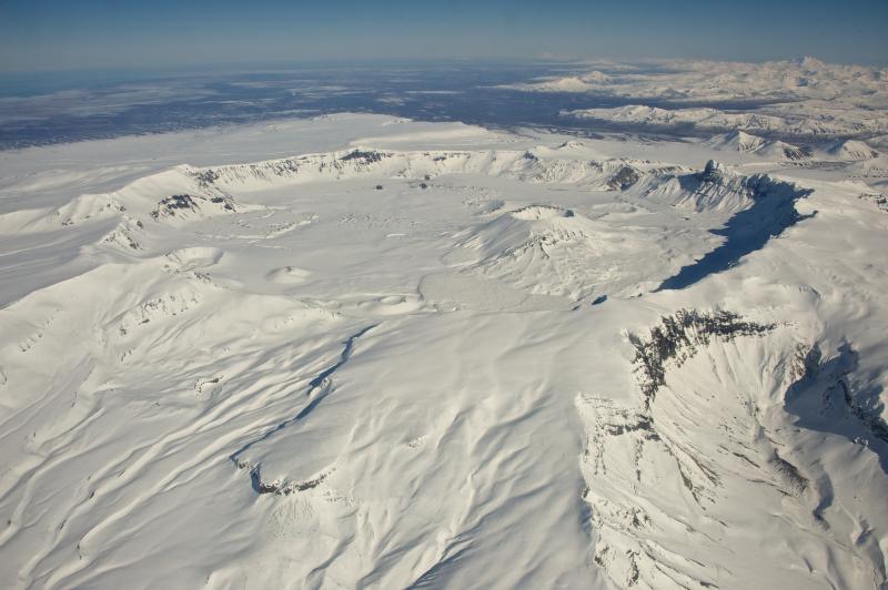
Aniakchak volcano, located in the central portion of the Alaska Peninsula, consists of a stratovolcano edifice with a 6 mile (10 km) diameter summit caldera. The caldera-forming eruption occurred around 3,500 years ago. Post-caldera eruptions have produced lava domes, tuff cones, and larger spatter and scoria cone structures, including Half-Cone and Vent Mountain, all within the caldera. The most recent eruption occurred in 1931 and created a new vent and lava flows on the western caldera floor while spreading ash over much of southwestern Alaska. Aniakchak volcano is 16 miles (26 km) southeast of the nearest community, Port Heiden, and 416 miles (670 km) southwest of Anchorage, Alaska.
Source : AVO.
Photo : Wood, Roy.
Colombia , Puracé – Los Coconucos volcanic chain :
Popayán, February 17, 2026, 2:00 PM
Regarding the monitoring of activity at the Puracé volcano and the Los Coconucos volcanic chain, the Colombian Geological Survey (SGC), an agency under the Ministry of Mines and Energy, reports the following:
During the week of February 10-16, 2026, earthquakes continued to occur, associated with fluid movements within the volcanic edifice. These earthquakes were of the Long Period (LP) and Tremor (TR) type. They were located below the crater of the Puracé volcano, at depths of less than 1 km, and were linked to circulation processes and the release of volcanic gases into the atmosphere. These gases dispersed according to the wind direction, reaching a maximum altitude of 850 m above the summit of the volcano.
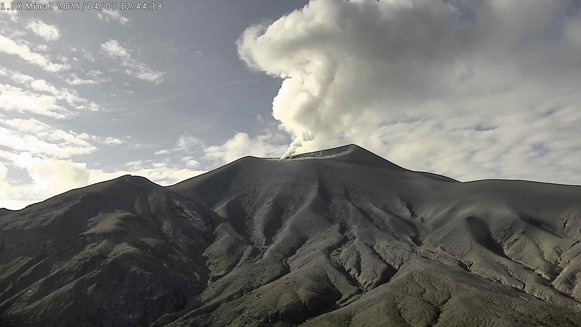
Compared to previous weeks, fracture seismicity has remained stable, both in terms of the number of events and the seismic energy released. It is primarily located between the Puracé, Piocollo, and Curiquinga volcanoes, at depths of 1 to 3 km. Sulfur dioxide (SO₂) emissions continue to be recorded, and gases continue to escape from fissures in the craters of the Curiquinga and Piocollo volcanoes, although no associated ash emissions have been identified to date. Satellite observations indicate that the energy of the thermal anomaly in the Puracé volcano crater remains high. Furthermore, the slow deformation process persists between the Puracé, Piocollo, and Curiquinga volcanoes, detected after the eruptive episode of Curiquinga on January 20, 2025.
In conclusion, the variations observed in the Puracé-Los Coconucos volcanic chain indicate that the system continues to evolve and that ash emissions and fallout could continue, depending on the prevailing wind direction. The public is advised to refrain from ascending to the upper part of the volcanic chain and to remain attentive to official bulletins from the Colombian Geological Survey (SGC).
The alert level for volcanic activity remains yellow: active volcano showing changes in monitored parameters and other manifestations.
Source et photo : SGC.
Guatemala , Fuego :
Atmospheric conditions: Clear skies
Wind: East
Rainfall: 0 mm
Activity:
Weak degassing is observed above the crater, reaching an altitude of 600 meters and dispersing to the west and southwest. Strombolian explosions of low, moderate, and high intensity are recorded at a rate of 5 to 7 per hour, generating a column of gas and ash that rises to 4,800 meters above sea level. Ash is dispersed over a distance of 10 to 20 km to the west and southwest. Streamfall of fine ash is reported in localities on the west and southwest flanks. Ballistic ejecta and fallout of incandescent volcanic material from the explosions are also observed on the west, south, and southwest flanks, even reaching vegetation.
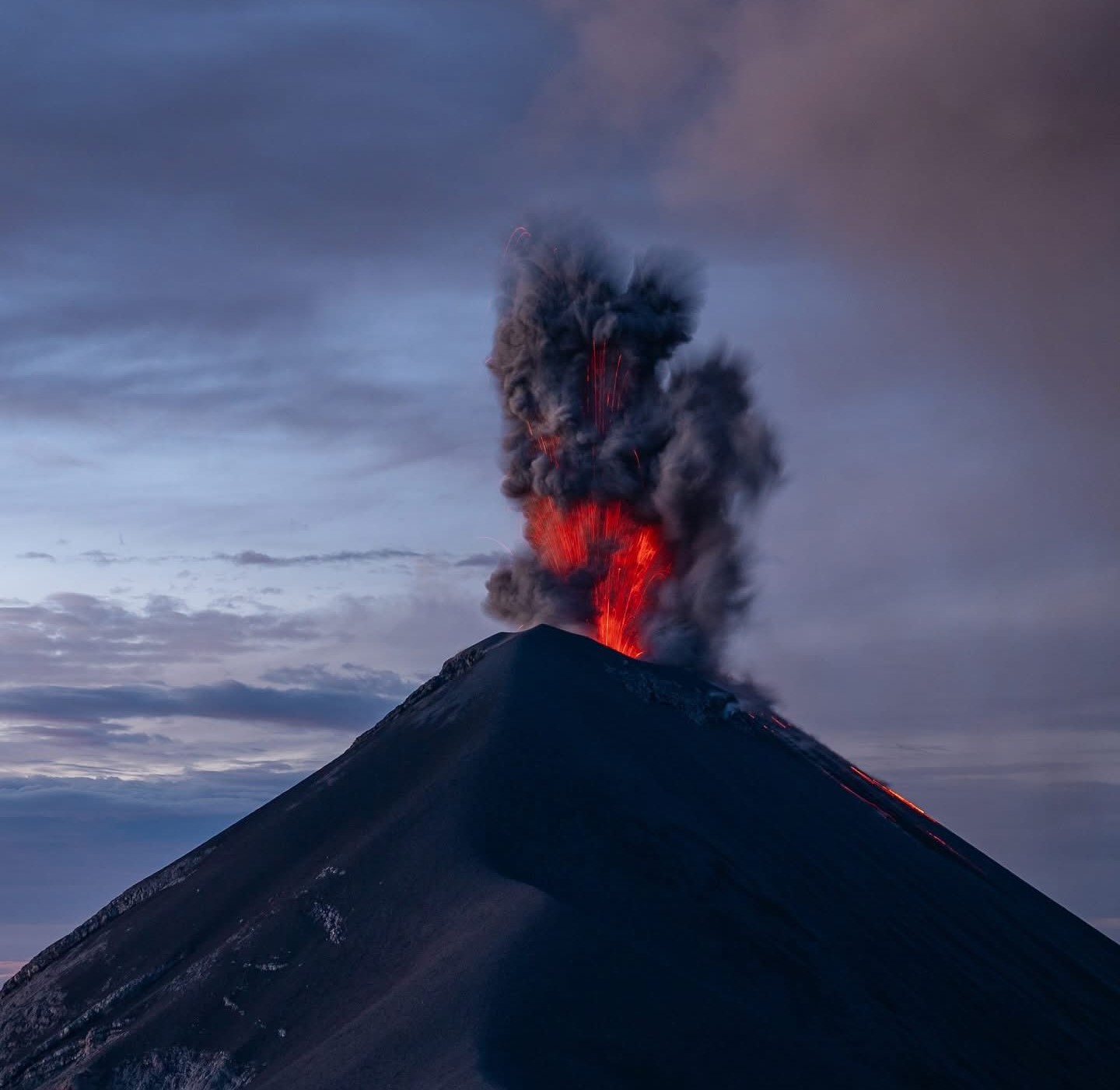
The explosive activity also generates rumbling, shockwaves, and noises similar to those of an aircraft turbine due to the continuous expulsion of gas. Moderate to strong explosions can produce audible rumblings in Antigua, Alotenango, Amatitlán, San Vicente Pacaya, Escuintla, El Rodeo, Siquinalá, Santa Lucía Cotzumalguapa, Yepocapa, and other locations. During the night and early morning, residual glows can be observed in the crater, which also manifest as incandescent pulses reaching heights of 100 to 300 meters.
Source : Insivumeh.
Photo : Diego Rizzo .