February 18 , 2026.
La Réunion Island , Piton de la Fournaise :
Press release from the Paris Institute of Earth Physics / Piton de la Fournaise Volcanological Observatory, February 17, 2026 – 11:00 AM local time – 7:00 AM UTC
Eruption in progress
The eruption that began on February 13, 2026, shortly after 10:00 AM (local time), at Piton de la Fournaise continues.
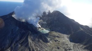
Only one eruptive site remains active. Lava fountains have built a volcanic cone adjacent to Piton Morgabim, on the south-southeast flank of the volcano.
Eruption site on February 17, 2026 at 8:00 AM local time (4:00 AM UTC) (©OVPF-IPGP)
The intensity of the eruptive tremor (an indicator of lava and gas emissions at the surface) remains generally stable, with a very slight decrease observed overnight. The tremor shows variations in amplitude (slight bursts separated by a few minutes) which appear to be correlated with variations in activity at the eruption site, resulting in variations in the height of the lava fountains.
Surface flow rates, estimated from satellite data via the HOTVOLC platform (OPGC – Université Clermont Auvergne), have shown values over the last 24 hours ranging from 1 to 23 m³/sec. It should be noted that depending on cloud cover, these estimates can vary rapidly and be zero in the event of total cloud cover.
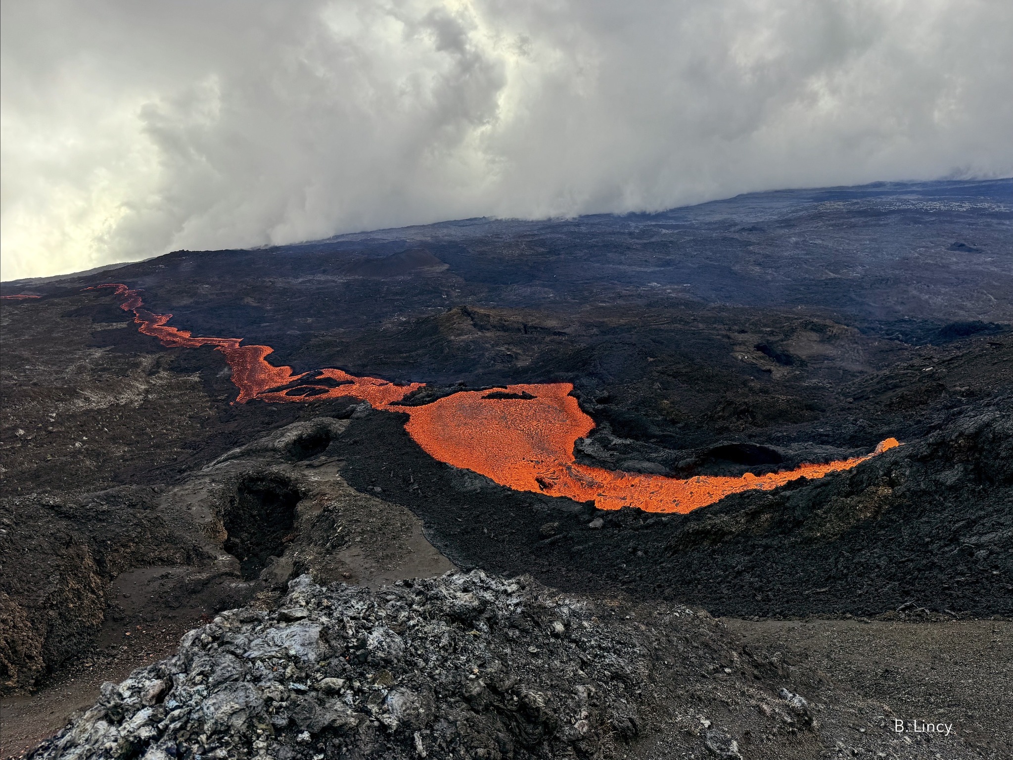
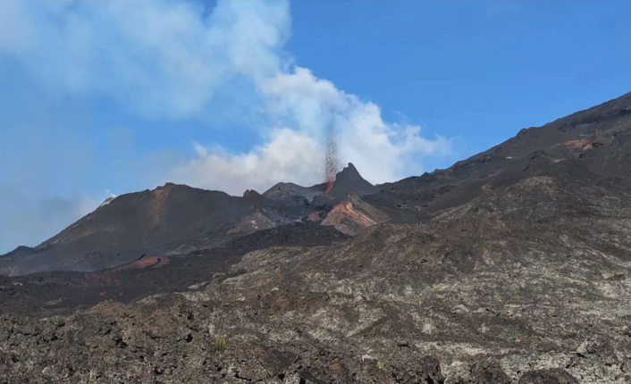
A field reconnaissance carried out this morning, with the assistance of the SAG and the PGHM, confirmed sustained activity at the eruptive site. The activity is concentrated in a single area, with lava fountains reaching approximately 15 meters in height above the forming cone. The eruptive cone is now about 15 to 20 meters high and remains open, allowing the lava to flow freely. Near the eruptive site, the lava flow remains well-channeled and flows through the remains of the old cone that collapsed on February 15, 2026 (see the OVPF press release of February 16, 2026) and the initial flows deposited at the start of the eruption.
The lava flow front remains stationary in the lower part of the Grandes Pentes area, approximately 2.6 km from the road and at an altitude of 660 meters. The active parts of the lava flow remain concentrated at the top of the Grandes Pentes, where the lava field is widening and thickening. Continued seismic activity beneath the summit indicates that the lava supply system remains under pressure; new fissure openings are still possible in the coming hours, particularly further downstream. The OVPF-IPGP remains on continuous alert to monitor the situation.
Alert Level 2.1
Source : OVPF/IPGP.
Photos : OVPF , B Lincy / Volkaventure .
Italy , Stromboli :
WEEKLY BULLETIN, February 9, 2026 to February 15, 2026 (Publication date: February 17, 2026)
ACTIVITY SUMMARY
Based on monitoring data, the following points should be noted:
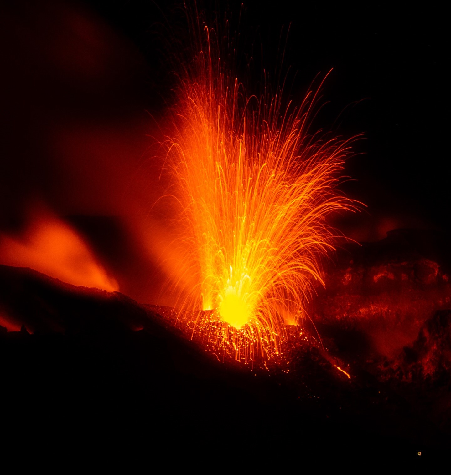
1) VOLCANOLOGICAL OBSERVATIONS: During the reporting period, ordinary Strombolian-type eruptive activity was observed. The total hourly frequency of explosions fluctuated around high values (21 to 24 events/hour). Intensity was mainly low to moderate in the North and Central-South crater areas.
2) SEISMOLOGY: The monitored seismic parameters showed no significant variation.
3) GROUND DEFORMATION: The GNSS monitoring network showed no significant variation. The tilt network is affected by technical issues.
4) GEOCHEMISTRY: Average SO2 flux.
CO2 flux from the ground in the Pizzo area (STR02): average to high values.
C/S ratio in the pen: high values.
Helium isotope ratio (R/Ra) dissolved in the thermal aquifer: no update. Last data: December 2, 2025 (high value: 4.44).
CO2 flux from the ground in the San Bartolo area: average values.
CO2 flux from the ground in the Scari area: almost stable (average values).
5) SATELLITE OBSERVATIONS: Satellite-observed thermal activity in the summit area was generally low.
VOLCANOLOGICAL OBSERVATIONS
During the observation period, Stromboli’s eruptive activity was characterized by analyzing images recorded by the INGV-OE monitoring cameras located at an altitude of 190 m (SCT-SCV) and at Punta dei Corvi (SPCT). The explosive activity was primarily due to five eruptive vents located in the North Crater area and at least two vents located in the Central-Southern area of the crater.
Due to heavy cloud cover on February 9, 10, 11, and 12, the crater terrace was not visible for a sufficient number of hours to accurately describe the eruptive activity.
Observations of explosive activity captured by monitoring cameras
In the North Crater area (N), five active winds were observed: two in sector N1 and three in sector N2. These winds produced explosive activity of low intensity (eruptive products reached heights of less than 80 m) and medium intensity (product heights between 80 and 150 m).
The eruptive products were primarily coarse-grained (bombs and lapilli). The average explosion frequency ranged from 18 to 21 events per hour.
In the Central-South (CS) crater area, two main vents were observed, generating explosions of fine and coarse material of low to medium intensity. The average explosion frequency ranged from 3 to 6 events per hour.
Source : INGV.
Photo : Stromboli stati d’animo / Sebastiano Cannavo .
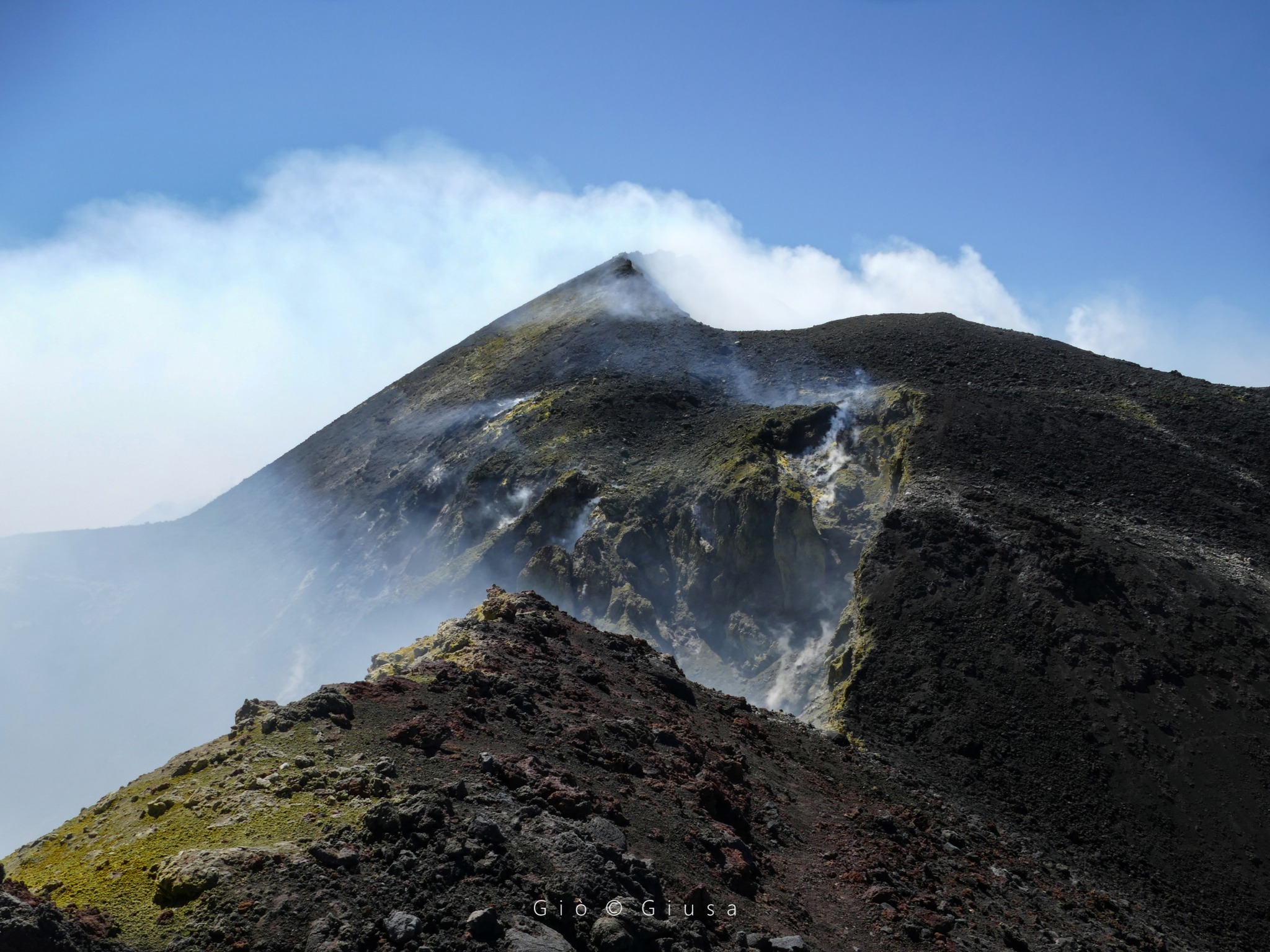
Italy / Sicily , Etna :
WEEKLY BULLETIN, February 9-15, 2026 (Publication date: February 17, 2026)
ACTIVITY SUMMARY
Based on monitoring data, the following points should be noted:
1) VOLCANOLOGICAL OBSERVATIONS: Degassing at varying rates at summit craters.
2) SEISMOLOGY: Low seismic activity due to fracturing. Tremor amplitude generally low.
3) INFRASOUND: Low infrasound activity.
4) GROUND DEFORMATION: Ground deformation monitoring networks did not show any significant variations during the week.
5) GEOCHEMISTRY: SO₂ flux at an average level.
Soil CO₂ flux (EtnaGas Network): average values.
Partial pressure of dissolved CO₂ in groundwater (EtnaWater Network): no update.
Helium isotope ratio at peripheral sites: average values (latest data from January 28, 2026).
6) SATELLITE OBSERVATIONS: During the past week, thermal activity observed by satellite in the summit area was generally low.
VOLCANOLOGICAL OBSERVATIONS
During the week, Etna’s volcanic activity was monitored by analyzing images from the INGV Osservatorio Etneo (INGV-OE) surveillance cameras. Due to adverse weather conditions, observation of volcanic activity by the cameras was very limited and irregular.
On days with good visibility, the activity affecting the summit craters consisted mainly of degassing.
Source : INGV.
Photo : Gio Giusa
Iceland , Reykjanes Peninsula :
Amount of magma accumulated beneath Svartsengi continues to increase
Updated 17 February
Approximately 22 million cubic metres have accumulated since the last eruption
This volume is approaching the higher end of what has been measured since the beginning of the ongoing events.
A magma intrusion and eruption along the Sundhnúkur crater row is the most likely scenario
Hazard assessment unchanged and valid until 3 March
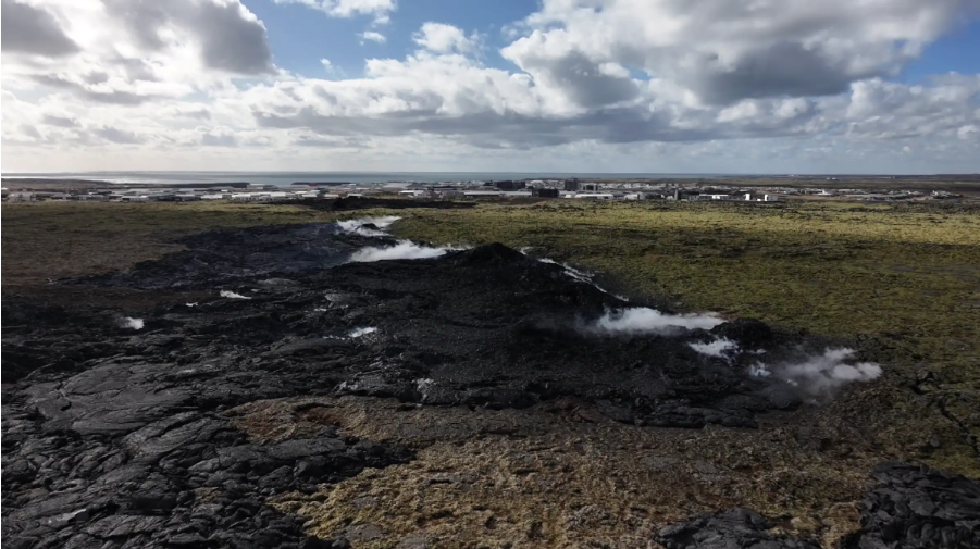
Magma accumulation
Magma accumulation beneath Svartsengi is slow but steady, as it has been in recent weeks. According to model calculations, approximately 22 million cubic metres of magma have now accumulated beneath Svartsengi since the last eruption in July. This is among the largest volumes measured since the beginning of the ongoing events.
As magma continues to accumulate and pressure within the system increases, the most likely scenario in the coming weeks is a magma intrusion propagating from Svartsengi towards the Sundhnúkur crater row, which could culminate in an eruption. If an eruption occurs, it is most likely to be similar to the events that have taken place so far along the Sundhnúkur crater row.
Seismic activity on the Reykjanes Peninsula
Seismic activity has remained unchanged in recent weeks, although low-level seismicity has been detected above the dyke. Continued microseismic activity is measured in the Vík area; this activity is interpreted as slip-related seismicity due to stress changes in the region.
Source et photo : IMO.
Colombia , Chiles / Cerro Negro :
San Juan de Pasto, February 17, 2026, 4:20 PM
Regarding the monitoring of activity at the Chiles-Cerro Negro Volcanic Complex (CVCCN), the Colombian Geological Survey (SGC), an agency under the Ministry of Mines and Energy, reports the following:
During the period from February 10 to 16, 2026, the main variations in monitored parameters compared to the previous week were as follows:
● Despite the fluctuating and characteristic behavior of seismic activity recorded by this volcanic complex, stability was observed in both the number of seismic events and the energy released. Seismicity associated with rock fracturing processes remained predominant, followed by seismicity related to fluid dynamics.
● Most of the localized earthquakes were concentrated at the summit of Chiles volcano and its southwest flank, in an area approximately 3 km wide, at depths between 2 and 6 km below its summit (4,700 m altitude). The maximum magnitude of 2.3 was recorded on February 10 at 9:11 a.m., with an epicenter located 4.5 km northwest of the summit of Chiles and a depth of 4 km. No earthquake was felt.
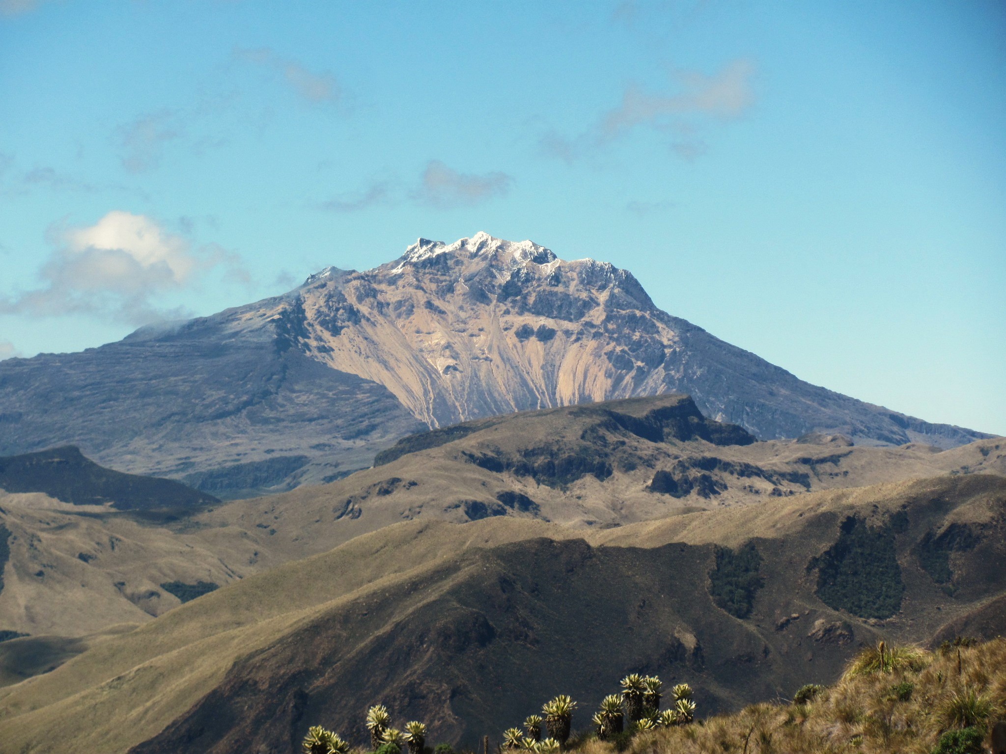
● Analysis of data from satellite sensors and ground stations continues to reveal variations related to deformation processes in the volcanic zone.
Based on the assessment and correlation of monitored parameters, the Geological Survey of Colombia (SGC) recommends closely monitoring its evolution by referring to weekly bulletins and other information published through its official channels, as well as instructions from local and departmental authorities and the National Unit for Disaster Risk Management (UNGRD).
Volcanic activity remains at the yellow alert level: active volcano with changes in the baseline behavior of monitored parameters and other manifestations.
Source et photo : SGC.