
December 12 , 2025.
India , Barren Island / Andaman Islands :
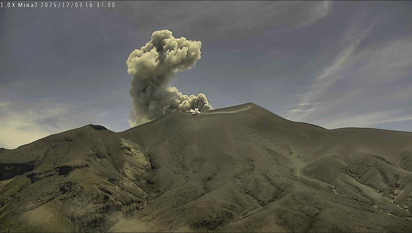
Eruptive activity continued at Barren Island during 28-29 November. The Darwin Volcanic Ash Advisory Centre (VAAC) reported that ash plumes were identified in satellite images rising 1.8-2.1 km (6,000-7,000 ft) a.s.l. and drifting SE, SW, and W. Weather clouds sometimes obscured views
Barren Island, a possession of India in the Andaman Sea about 135 km NE of Port Blair in the Andaman Islands, is the only historically active volcano along the N-S volcanic arc extending between Sumatra and Burma (Myanmar). It is the emergent summit of a volcano that rises from a depth of about 2250 m. The small, uninhabited 3-km-wide island contains a roughly 2-km-wide caldera with walls 250-350 m high.
The caldera, which is open to the sea on the west, was created during a major explosive eruption in the late Pleistocene that produced pyroclastic-flow and -surge deposits. Historical eruptions have changed the morphology of the pyroclastic cone in the center of the caldera, and lava flows that fill much of the caldera floor have reached the sea along the western coast.
Sources: Darwin Volcanic Ash Advisory Centre (VAAC) , GVP.
Photos : Arunava Pramanick
Iceland , Reykjanes Peninsula :
Increased Likelihood of an Eruption is ongoing on the Sundhnúkur Crater Row
Updated 11 December 2025
Key points
Magma accumulation has been slow but steady in recent weeks
As long as magma continues to accumulate, a new eruption must be expected
Uncertainty regarding the timing of the next eruption is greater when magma accumulation is slow
The amount of magma that has accumulated beneath Svartsengi since the last eruption is the fifth largest to date
The hazard assessment remains unchanged until 6th of January unless activity changes
Magma Accumulation Slow but Steady in Recent Weeks
The magma accumulation process under Svartsengi is still ongoing . In the run-up to eruptions on the Sundhnúkur crater row, the rate of magma accumulation has varied. Looking at the past eruptions, model calculations show that the rate of inflow has gradually decreased with each eruption. Over the past two weeks, however, the rate has remained fairly steady.
As long as magma is accumulating, the likelihood of a dike propagation or an eruption remains elevated. The uncertainty regarding the timing of the next eruption is greater when accumulation is slow. Based on the current accumulation rate, the timing uncertainty spans months.
The Amount of Magma Accumulated Beneath Svartsengi Since the Last Eruption is the Fifth Largest to Date
Measurements and model calculations indicate that since March 2024, the volume of magma required to trigger a new diking event or eruption appears to have increased compared to earlier events. According to the models, the magma volume that has accumulated beneath Svartsengi between eruptions since March 2024 has varied between 17 and 23 million cubic meters. Model calculations now show that just over 17 million cubic meters of magma have been added to the accumulation area beneath Svartsengi since the last eruption in July. This is similar to the volume observed just before the May 2024 eruption.
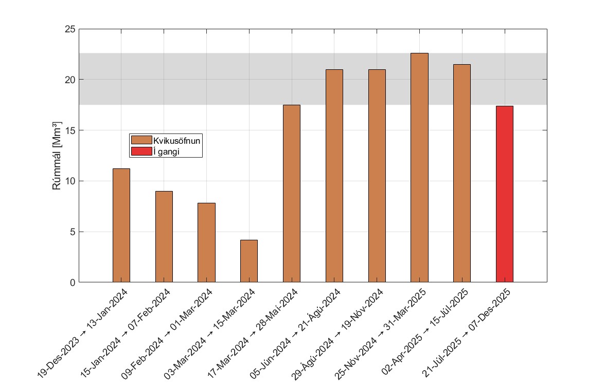
Total modelled volumes for each inflation episode at Svartsengi since December 2023. The orange bars show the total volume that accumulated before the next intrusion or eruption began. The red bar represents the volume accumulated from the July eruption to the present day. The grey shaded area indicates the range of inflation volumes to re-accumulate beneath Svartsengi to trigger the next event.
Seismic Activity
Seismic activity in the area remains low. Twelve small earthquakes have been measured in the last two weeks, located between Stóra-Skógfell and Grindavík.
Source : IMO.
Photos : Steinninn , IMO.
Indonesia , Semeru :
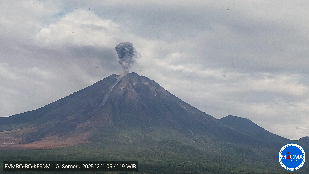
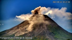
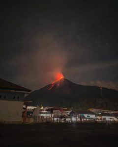
Mount Semeru erupted on Thursday, December 11, 2025, at 06:41 WIB. An ash column was observed approximately 1,100 meters above the summit (at an altitude of about 4,776 meters). This ash column, white to gray in color, was of moderate intensity and directed southwest. At the time of writing, the eruption was still ongoing.
VOLCANO OBSERVATORY NOTICE FOR AVIATION – VONA
Issued : December 11 , 2025
Volcano : Semeru (263300)
Current Aviation Colour Code : ORANGE
Previous Aviation Colour Code : orange
Source : Semeru Volcano Observatory
Notice Number : 2025SMR3521
Volcano Location : S 08 deg 06 min 29 sec E 112 deg 55 min 12 sec
Area : East java, Indonesia
Summit Elevation : 11763 FT (3676 M)
Volcanic Activity Summary :
Eruption with volcanic ash cloud at 23h41 UTC (06h41 local).
Volcanic Cloud Height :
Best estimate of ash-cloud top is around 15283 FT (4776 M) above sea level or 3520 FT (1100 M) above summit. May be higher than what can be observed clearly. Source of height data: ground observer.
Other Volcanic Cloud Information :
Ash cloud moving to southwest. Volcanic ash is observed to be white to gray. The intensity of volcanic ash is observed to be medium.
Remarks :
Eruption recorded on seismogram with maximum amplitude 22 mm and maximum duration 129 second.
Source et photo : PVMBG.
Colombia , Puracé – Los Coconucos volcanic chain :
Popayán, December 11, 2025, 9:00 AM
Regarding the monitoring of activity in the Los Coconucos volcanic chain, the Colombian Geological Survey (SGC), an agency under the Ministry of Mines and Energy, reports the following:
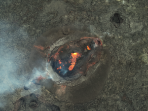
Since the publication of yesterday’s extraordinary bulletin and up to the date of this announcement, earthquakes related to fluid movements within the volcanic edifice continue to be recorded. These include long-period (LP) earthquakes, tremor pulses (TR), and continuous tremor. This seismicity is primarily located beneath the Puracé volcano crater and is linked to the internal dynamics of gases and their emission into the atmosphere. In addition, low-magnitude seismic signals, associated with rock fracturing, were recorded within a 3 km radius around the Purace volcano crater, at depths of less than 3 km.
Some seismic activity was accompanied by ash emissions that dispersed mainly to the northwest, following the wind direction, reaching column heights of up to 700 meters. A total of 10 ash emissions were recorded, prompting alerts to the Civil Aviation Authority.
In addition, the monitoring network reported ashfall and a faint sulfur odor in Cristales, as well as in Pululó, Anambío, and Coconuco to the northwest, and in Crucero de la Mina and the former Puracé police station to the north.
Significant levels of sulfur dioxide (SO₂) emissions into the atmosphere continue to be detected by satellite, dispersing primarily to the southwest within a 300-kilometer radius of the volcano. Similarly, a temperature increase continues to be recorded in the crater area, possibly linked to the emission of hot gases from within the volcano. Although the orange alert level remains in effect, temporary fluctuations in volcanic activity are possible, meaning that it may sometimes decrease compared to previous days or weeks. However, this does not necessarily imply that the volcano has returned to a stable level of activity. For a return to a more stable level (yellow alert), a reasonable amount of time is needed to assess all monitored parameters and determine trends that would indicate reliable stability.
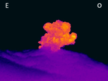
Thermal imaging camera footage from Mina, located 2.2 km north of the Puracé volcano. A gas plume was recorded at 1:46 a.m. on December 11, 2025, reaching a height of 700 meters above the summit of the Puracé volcano.
Given the above, the Colombian Geological Survey (SGC) recommends staying away from the volcano’s crater and surrounding areas, closely monitoring the activity through special bulletins and information published on our official channels, and following the instructions of local and regional authorities and the National Unit for Disaster Risk Management (UNGRD).
The volcanic activity level remains at ORANGE alert: volcano exhibiting significant variations in monitored parameters.
Source et photos : SGC.
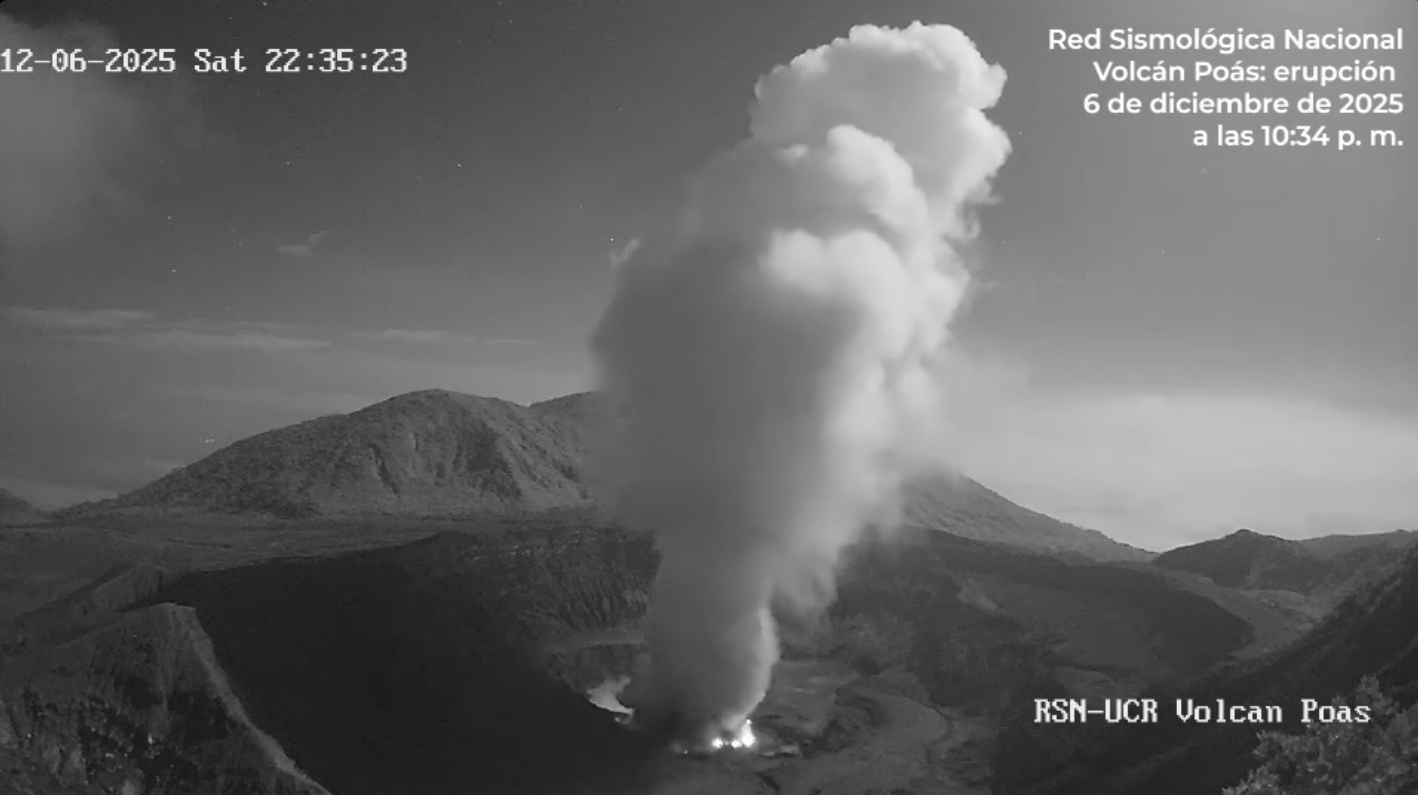
Costa Rica , Poas :
Latitude: 10.20°N
Longitude: 84.23°W
Altitude: 2,687 m
Current Activity Level: Alert
This week, a sequence of 24 distal volcano-tectonic events was detected between December 3 and 4. The largest reached a magnitude of 2.1. This sequence occurred northwest of the volcano, near Cerro Congo. Previously, at 5:28 p.m. on December 2, an unusual seismo-acoustic event, exhibiting both high and low frequencies, was detected, following a brief increase in seismic tremor. Background seismic tremor remains generally low this week, with a few brief increases in intensity. Acoustic tremor remains almost nonexistent. The number of long-period events has decreased compared to last week. The geodetic network is not recording any significant deformation of the volcano.
The Boca C MultiGAS station measured an average SO₂/CO₂ ratio of 1.3 ± 0.5 this week, similar to last week’s value (1.0 ± 0.5). The H₂S/SO₂ ratio decreased to 0.03 ± 0.01. The ExpoGAS station at the Visitor Lookout measured a maximum of 0.8 ppm of SO₂ this week, which is a low concentration. DOAS stations detected an SO₂ flux of 214 ± 27 t/d, lower than the previous week’s value of 296 ± 48 t/d. Satellite detection of atmospheric SO₂ is now rare, having occurred only once this week, with a low of 36 tonnes on November 30. The lake level continues to rise, increasing by 0.6 m this week. The lake temperature was measured at over 75°C and that of the fumaroles at over 125°C.
Source : Ovsicori .
Photo : RSN
Ping : Gunung Semeru Meletus Lagi 11 Desember 2025: Kolom Abu Tercatat Capai Sekitar 1,100 Meter – Outdoor Oasis Adventure Gear Rentals