April 5 ,2026
La Réunion Island , Piton de la Fournaise :
Press release from the Paris Institute of Earth Physics / Piton de la Fournaise Volcanological Observatory, April 5, 2026 – 8:40 a.m. local time – 4:40 a.m. UTC
Tremor
Tremor has been recorded since 8:40 p.m. (local time, 4:40 p.m. UTC) on April 3. The source of this tremor is located on the east-southeast flank of the volcano and is positioned in the same location as during the eruptive activity phases from February 23 to April 3.
Over the past 24 hours, the tremor amplitude has remained low, while showing several fluctuations, including a slight increase observed around 3:00 AM local time (11:00 PM UTC). This activity is not accompanied, at this stage, by lava emissions at the surface; only a small plume of gas is being emitted from the eruptive fissure associated with the activity from February 13 to April 3, located at an altitude of 2056 m on the east-southeast flank of the volcano. This tremor nevertheless indicates the presence of magma at shallow depths; thus, a resumption of lava emissions cannot be ruled out.
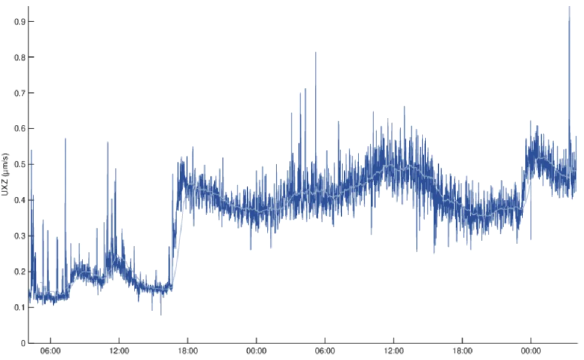
Amplitude of the eruptive tremor measured at the FOR seismic station located on the south-southeast flank of the volcano, over the last 48 hours. The vertical axis indicates the tremor amplitude (in micrometers per second) and the X-axis represents the time in UTC (local time -4 hours) (©OVPF-IPGP).
It should be noted that in the past, phases of tremor without lava emission have been observed at Piton de la Fournaise, although this remains rare, such as at the end of the September-October 2022 eruption, during which this phase lasted just over 27 hours.
Source : OVPF / IPGP.
Photos : Sophie Person / la 1ere . fr , OVPF.
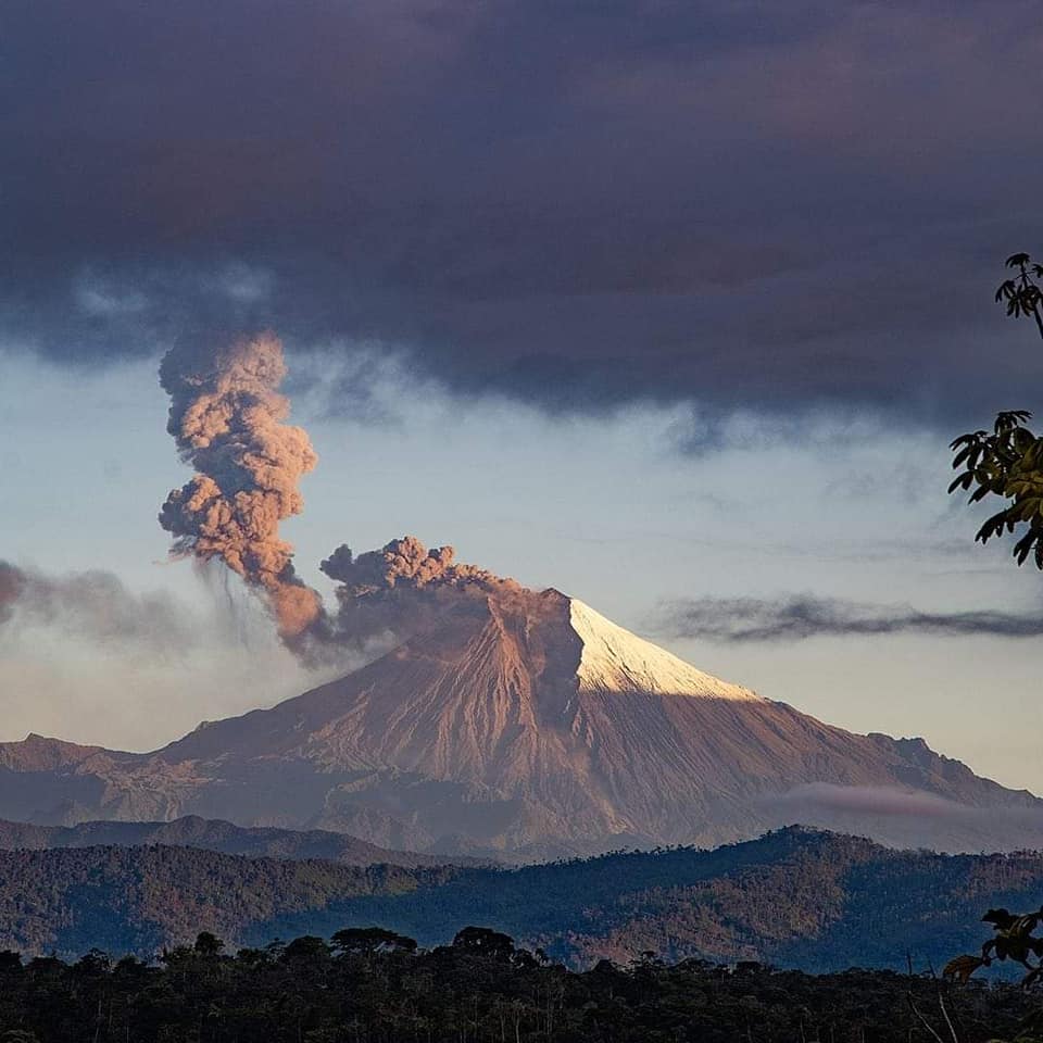
Indonesia , Slamet :
INCREASED ACTIVITY AT SLAMET VOLCANO ON APRIL 3, 2026
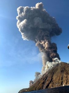
On April 3, 2026, visual changes began to be observed in the crater of Mount Slamet, in the form of a column of white smoke reaching a maximum height of approximately 300 meters above the crater rim. Continuous smoke emanating from the crater indicates degassing activity, namely the release of magmatic gases from the magma to the surface through the crater.
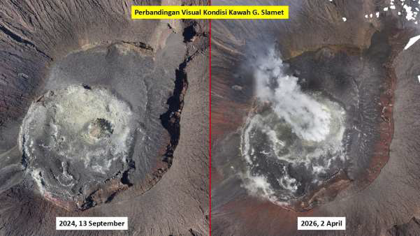
Based on the results of thermal image analysis of the Slamet volcano crater, an increase in the maximum temperature was observed, from approximately 247.4°C on September 13, 2024, to 411.2°C on April 2, 2026. This increase represents a significant rise in the crater’s thermal activity. The thermal anomaly distribution in 2024 was still localized in the central section of the crater, while in 2026, it had expanded to form a circular pattern around the crater wall. Changes in temperature distribution patterns indicate the development of fracture systems. The expansion of this thermal anomaly zone demonstrates an increased intensity of the degassing process within the crater area.
Seismicity data for the period from March 16 to April 3, 2026, recorded 866 gust earthquakes, 620 low-frequency earthquakes, one deep volcanic earthquake, 11 distant tectonic earthquakes, and one continuous tremor with an amplitude of 1 mm, with a dominant value of 0.5 mm.
Low-frequency earthquakes on Mount Slamet were recorded intermittently. Since March 22, 2026, this activity has increased, with recordings becoming increasingly assertive and continuous from March 27, 2026, to early April 2026. These low-frequency earthquakes are recorded regularly with relatively uniform amplitude and duration, associated with increased magmatic gas activity.
From deformation monitoring, distance measurements using EDM show a simultaneous longitudinal pattern of (deflation), indicating that the magma has passed the reflector and is probably in a shallow/higher position than the station location and from tilt monitoring with inclinometer shows a decrease (deflation) on the radial axis of St. Cilik and an increase (swelling) at St. Bambangan, indicating a migration of magma from depths (around St. Cilik) to shallower depths (towards St. Bambangan).
Observations and monitoring data analysis show an increase in pressure beneath the Slamet volcano, triggering shallow earthquakes and increasing the likelihood of an eruption.
The current potential hazard lies in phreatic eruptions producing ash and mudfall, or in magmatic eruptions ejecting incandescent material that strikes the area around the peak within a radius of approximately 2 km. High concentrations of volcanic gases are also present, with distribution limited to the crater/peak.
As of April 3, 2026, the activity level of Slamet volcano remains at Level II (Waspada).
Source et photos : PVMBG.
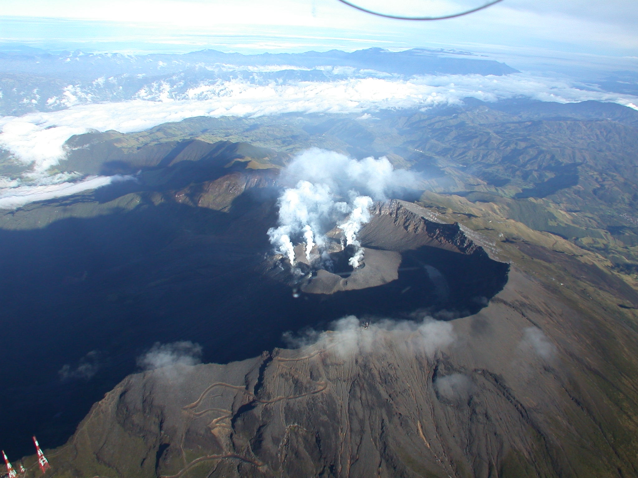
Hawaii , Kilauea :
HAWAIIAN VOLCANO OBSERVATORY DAILY UPDATE,U.S. Geological Survey
Saturday, April 4, 2026, 8:23 AM HST (Saturday, April 4, 2026, 18:23 UTC)
19°25’16 » N 155°17’13 » W,
Summit Elevation 4091 ft (1247 m)
Current Volcano Alert Level: WATCH
Current Aviation Color Code: ORANGE
Activity Summary:
Small precursory overflows continue this morning from the south vent. The summit is currently inflating. Additional overflows and associated spattering are likely to continue until the start of episode 44 fountaining. The current forecast window for episode 44 is April 6-14.
No significant activity has been noted along Kīlauea’s East Rift Zone or Southwest Rift Zone.
NOTE: The National Weather Service (NWS) issued a Special Weather Statement yesterday about the potential for tephra fall from episode 44 in downwind communities especially if it begins in the middle to end of next week when the NWS has forecast possible southerly winds.
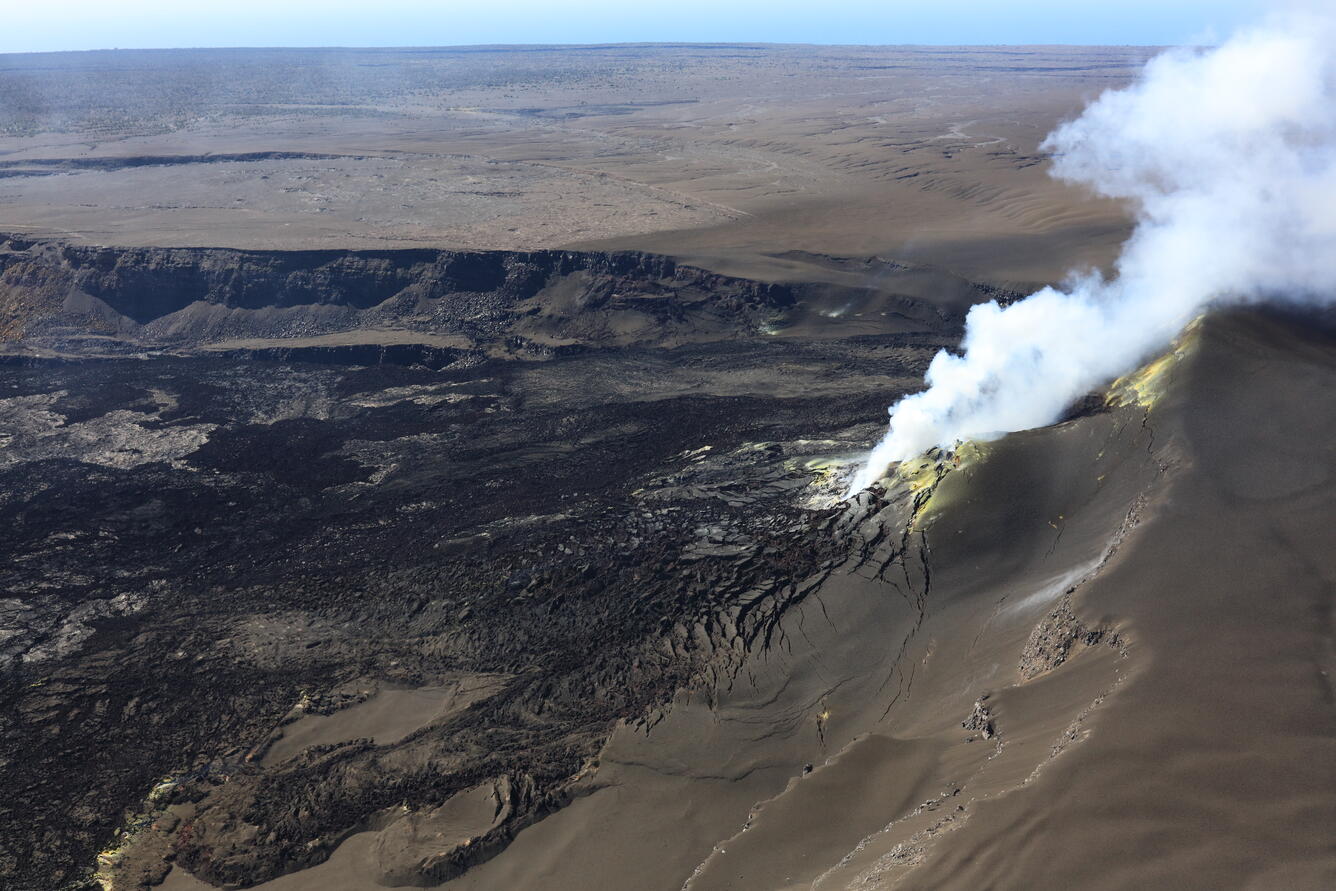
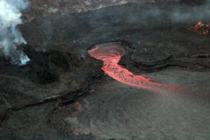
USGS Hawaiian Volcano Observatory scientists completed a helicopter overflight of the Kīlauea summit on March 31, 2026, during which they captured this overview photo of the eruptive vents in western Halema‘uma‘u crater. Both the north and south vents were vigorously degassing at the time, and a low pass over the two revealed a weakly spattering lava pond about 30 meters (100 feet) down in the south vent.
Summit Observations:
Overflows and related spattering continued from the south vent overnight, though there was a gap in flows from about 8:30 p.m. HST last night to 5:30 a.m. HST this morning. The north vents continued to glow strongly and continuously overnight. Small dome fountains about 3-6 feet (1-2 meters) high accompanied the overflows. These events were followed by more vigorous spattering during drainback.
Seismic tremor is continuous with frequent small, poorly-defined bursts possibly related to rise and fall of magma in the vents. Two small-magnitude earthquakes were recorded at the summit during the past day.
Summit tiltmeters UWD and SMC continue to record inflation since the end of episode 43. The UWD tiltmeter has recorded an estimated 24.6 microradians of inflationary tilt since the end of episode 43. This is a gain of about one microradian in the last 24 hours.
During eruptive pauses, like the current conditions, the SO2 emission rate from the summit has varied within a typical range of 1,000 to 5,000 tonnes of SO2 per day. Winds remain steady at around 10-15 miles per hour out of the northeast.
Rift Zone Observations:
Rates of seismicity and ground deformation remain low in the East Rift Zone and Southwest Rift Zone. SO2 emissions from the East Rift Zone remain below the detection limit.
Source : USGS.
Photo : USGS / M. Zoeller.
Ecuador , Sangay :
DAILY REPORT ON THE STATE OF SANGAY VOLCANO, Saturday, April 4, 2026.
Information Geophysical Institute – EPN.
Surface Activity Level: High, Surface Trend: No Change
Internal Activity Level: Moderate, Internal Trend: No Change
Seismicity: From April 3, 2026, 11:00 AM to April 4, 2026, 11:00 AM:
Seismicity:
Due to data transmission problems, it was not possible to count the seismic events recorded at the reference station.
Rainfall/Lahars:
Rainfall was recorded in the volcano area, but it did not generate mudflows or debris. In the event of heavy rains, the accumulated materials could be remobilized, causing mud and debris flows that would rush down the sides of the volcano and flow into nearby rivers.
Emissions/Ash Column:
Since yesterday afternoon, several gas and ash emissions have been recorded by the monitoring camera system, reaching an altitude of 1,000 meters above the crater and moving toward the southwest and southeast. The Washington VAAC agency issued three reports indicating ash emissions at altitudes between 1,400 and 1,700 meters above the crater, moving toward the southeast and south-southeast.
Other Monitoring Parameters:
Over the past 24 hours, the FIRMS satellite system recorded 2 thermal anomalies, the MIROVA-MODIS system 1 thermal anomaly, the MIROVA-VIIRS 375 system 2 thermal anomalies, and the MIROVA-VIIRS 750 system 2 thermal anomalies.
Note: The volcano has remained shrouded in clouds since yesterday afternoon until the time of writing.
Alert level: Yellow
Source : IGEPN
Photo : Volcan Sangay / FB.
Colombia , Galeras :
San Juan de Pasto, March 31, 2026, 3:00 PM
Regarding the monitoring of activity at the Galeras volcano, the Colombian Geological Survey (SGC), an agency under the Ministry of Mines and Energy, reports the following:
For the period from March 24 to 30, 2026, the main variations in monitored parameters compared to the previous week were as follows:
● In a context of low volcanic activity, a slight increase in seismic frequency and a decrease in energy released were observed. Seismicity associated with rock fracturing within the volcanic edifice remained predominant, followed by events related to fluid movement.
● Fracture seismicity was dispersed within a radius of less than 10 km around the crater and at depths between 0.5 and 10 km from the summit (4,200 m altitude). The strongest earthquake occurred on March 26 at 8:44 PM, with a magnitude of 1.4 and a depth of 6.5 km. It was not felt.
● Low-altitude plumes of white gas were observed. Their dispersion was variable, and they originated primarily from the fumarole fields of El Paisita (northern flank) and Las Chavas (western flank).
● All other volcanic monitoring parameters remained stable.
In light of the above, the Geological Survey of Colombia (SGC) recommends closely monitoring the evolving situation by consulting the weekly bulletins and other information published through its official channels, as well as the instructions of local and departmental authorities and the National Unit for Disaster Risk Management (UNGRD).
Volcanic activity remains at the yellow alert level: active volcano exhibiting changes in the baseline behavior of monitored parameters and other manifestations.
Source et photo : SGC.