April 4 2026.
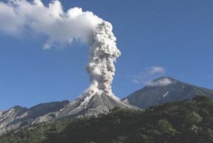
La Réunion Island , Piton de la Fournaise :
Press release from the Paris Institute of Earth Physics / Piton de la Fournaise Volcanological Observatory, April 4, 2026 – 6:30 a.m. local time – 2:30 a.m. UTC
Tremor
Tremor has been recorded since 8:40 p.m. (local time, 4:40 p.m. UTC) on April 3. The source of this tremor is located on the south-southeast flank of the volcano and is positioned in the same location as during the eruptive activity phases from February 23 to April 3.
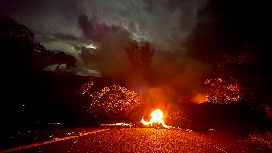
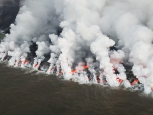
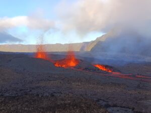
The last lava flows from Piton de la Fournaise reached the RN2 highway, even though the eruption officially ended at 12:10 a.m. on Friday, April 3, 2026.
The amplitude of this tremor remains weak at present, and no surface lava emissions associated with this renewed tremor are visible on the observatory’s cameras. This tremor nevertheless indicates the presence of magma at shallow depths and the emission of gases; therefore, a resumption of lava flows cannot be ruled out.
No surface lava emissions associated with this renewed tremor are visible on the observatory’s cameras.
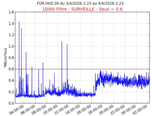
Amplitude of the eruptive tremor measured at the FOR seismic station located on the south-southeast flank of the volcano, over the last 24 hours (©OVPF-IPGP)
It should be noted that in the past, phases of tremor without lava emission have been observed at Piton de la Fournaise, although this remains rare.
« It’s difficult to count the lava flows because many have crossed the road. Last night (April 2nd) we had new flows crossing the road and this morning around 9:50 am, one flow crossed the road in half an hour, so it’s quite dynamic, » says Aline Peltier, director of the Piton de la Fournaise Volcanological Observatory. « However, drone overflights show that at the moment there are no more flows upstream of the road, I say at the moment because the situation is evolving very quickly, » she adds.
Source : OVPF-IPGP
Photos: Loïs Mussard , OVPF .
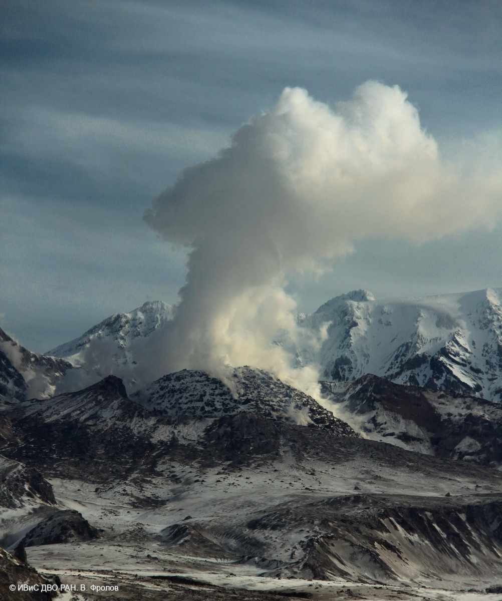
Kamchatka , Sheveluch :
KVERT VOLCANIC ACTIVITY NOTICE (VAN)
Issued: April 2 , 2026
Volcano: Sheveluch (CAVW #300270)
Current aviation colour code: ORANGE
Previous aviation colour code: red
Source: KVERT
Notice Number: 2026-35
Volcano Location: N 56 deg 38 min E 161 deg 19 min
Area: Kamchatka, Russia
Summit Elevation: 3283 m (10768.24 ft), the dome elevation ~2500 m (8200 ft)
Volcanic Activity Summary:
An explosive-extrusive eruption of the volcano continues, a new block of lava continues to grow in the northern part of the lava dome. Satellite data by KVERT showed: explosions sent ash up to 10.7-11 km a.s.l. at 14:09 UTC, and ash cloud continues to move for 563 km to the northeast of the volcano. No new ash explosions have been observed on the volcano.
An explosive-extrusive eruption of the volcano continues. Ash explosions up to 12 km (39,400 ft) a.s.l. could occur at any time. Ongoing activity could affect international and low-flying aircraft.
Volcanic cloud height: NO ASH CLOUD PRODUSED
Other volcanic cloud information: NO ASH CLOUD PRODUSED
Source : Kvert.
Photo : V. Frolov. IVS FEB RAS ( archive).
Indonesia , Sorikmarapi :
ACTIVITY LEVEL OF SORIKMARAPI VOLCANO, NORTH SUMATRA, RISES FROM LEVEL I (NORMAL) TO LEVEL II (WASPADA)
Sorikmarapi volcano is located in the Mandailing Natal Regency, North Sumatra Province. Its summit is located at coordinates 0° 41′ 11.72″ N and 99° 32′ 13.09″ E (2,145 meters above sea level). Volcanic activity is monitored visually and instrumentally from the volcanological observation post in the village of Sibangor Tonga.
Eruptions of Mount Sorikmarapi are characterized by phreatic eruptions, ash eruptions, and mudflows, which have historically occurred in 1830, 1879, 1892, 1893, 1917, 1970, 1986, and 1987. Eruptions occur not only at the main crater but also at surrounding features, such as the Sibangor Tonga and Sibangor Julu craters.
On April 2, 2026, a significant increase in deep volcanic earthquakes was observed. On that date, 115 deep volcanic earthquakes, 4 earthquakes of intensity II to IV on the MMI scale, and 11 deep tectonic earthquakes were recorded. On April 3, 2026, seismicity remained high. As of 6:00 PM WIB (Western Indonesian Time), 49 deep volcanic earthquakes (VA), 3 local tectonic earthquakes, 1 magnitude IV earthquake on the MMI scale, and 4 distant tectonic earthquakes have been recorded. The increase in deep volcanic earthquakes is linked to the upwelling of magma from the volcano’s depths to the surface, which requires heightened vigilance.

In response to this increased seismicity, the Center for Volcanology and Geological Hazard Mitigation (PVMBG), under the Bandung Geological Agency, has raised the activity level of Mount Sorikmarapi from Level I (Normal) to Level II (Waspada), effective April 3, 2026, at 9:00 PM WIB, and issues the following recommendations:
The public and visitors/tourists are advised to stay within 1,500 meters of the main crater/summit of Mount Sorikmarapi.
The public and visitors/tourists are advised to stay away from Sibangor Tonga Crater, Sibangor Julu Crater, and other craters around Mount Sorikmarapi to avoid potential hazards from sudden eruptions of mud and/or toxic gases.
Source : PVMBG.
Photo : GVP.
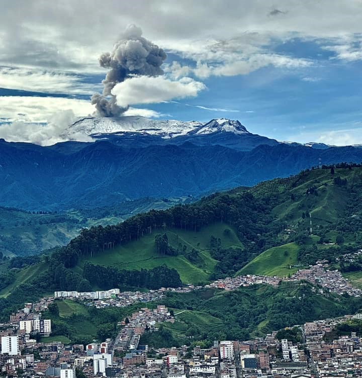
Colombia , Nevado del Ruiz :
Manizales, March 31, 2026, 5:30 PM
Regarding the monitoring of activity at the Nevado del Ruiz volcano, the Geological Survey of Colombia (SGC), an agency under the Ministry of Mines and Energy, reports the following:
During the week of March 24-30, 2026, the volcano continued to exhibit unstable behavior. Compared to the previous week, the main variations in some monitored parameters were as follows:
– Seismicity associated with fluid dynamics within the volcanic conduits, characterized by short-duration signals, increased in the number of recorded events and in seismic energy released. However, the energy levels of these signals remained low. During this week, no long-duration seismic signals were recorded, and no pulsatile ash emissions or variations in the apparent temperature of the emitted materials, associated with this type of seismic signal, were confirmed.
Seismic activity associated with rock fracturing processes within the volcanic edifice increased, both in the number of recorded events and in the seismic energy released. The earthquakes were primarily located in the Arenas crater and on the volcano’s eastern, southeastern, and south-southeast flanks, within 4 km of the crater. To a lesser extent, scattered earthquakes were also recorded on other flanks of the volcano, up to 11 km from the crater. In general, the depth of the earthquakes ranged from less than 1 km to 7 km relative to the reference level. The largest earthquake of the week, with a magnitude of 1.6, was recorded on March 24 at 5:27 a.m. It was associated with a slight increase in seismic activity observed that day. This event occurred 3 km east-southeast of the Arenas crater, at a depth of 4 km.
The emission of water vapor and volcanic gases, primarily sulfur dioxide (SO₂), into the atmosphere from the Arenas crater was variable. The estimated SO₂ flux, associated with degassing processes, remained low and decreased compared to the previous week. This decrease is partly attributed to the prevailing wind direction, which blew toward the eastern flank (northeast to southeast) of the volcano, where the coverage of the monitoring stations is less extensive. Further monitoring using satellite data also observed low levels of SO₂ emissions.
The height of the gas and water vapor plume generally remained below 500 m above the volcano’s summit, although it occasionally exceeded this height, reaching a maximum of 800 m on March 30 at 5:42 a.m. The plume’s dispersion direction varied, with a slight tendency toward the eastern flank (from northeast to southeast) and also toward the western flank (from northwest to southwest) of the volcano.
Monitoring of thermal anomalies at the bottom of the Arenas crater, conducted via satellite platforms, showed that energy levels remained low.
Source : SGC
Photo : Alex Jimenez Matiz ( archive).
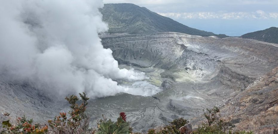
Costa Rica , Poas :
OVSICORI-UNA Volcano Monitoring Weekly Bulletin
Latitude: 10.20°N
Longitude: 84.23°W
Altitude: 2,687 m
Current Activity Level: Alert
Seismic activity at Poás remains dominated by long-period (LP) earthquakes, with a slight decrease in recent days, totaling approximately 100 events per day. On the morning of March 22, seismographs recorded a small swarm of low-amplitude, near-surface volcano-tectonic (VT) earthquakes. At approximately 8:15 a.m., a small eruption without ash emission was recorded, with a plume rich in water vapor and gas escaping from vent A at the bottom of the crater. Seismic tremor increased slightly in intensity on March 22 before decreasing in the following days. Its intensity varies slightly and sporadically, but it generally remains relatively stable. The geodetic network does not record any significant crustal deformation.
The Boca A MultiGAS station recorded an increase in the SO₂/CO₂ ratio, rising from values close to 1.1 to a weekly average of 2.1 ± 1.1, with a peak of 3.8 recorded on Saturday, March 21. At the visitor lookout, SO₂ concentrations reached 4.5 ppm. This week, DOAS stations recorded an average SO₂ flux of approximately 70 t/d, with a peak of 350 t/d. The European SENTINEL satellite has detected SO₂ masses not exceeding 80 tonnes in the atmosphere above Lake Poás since January 4, 2016.
The level of this hyperacidic lake began a rapid decline this week (minimum -1.5 m), has a milky gray color, and its surface is experiencing significant evaporation.
Source et photo : Ovsicori