April 12 , 2026.
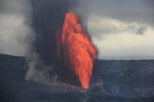
La Réunion Island , Piton de la Fournaise :
Press release from the Paris Institute of Earth Physics / Piton de la Fournaise Volcanological Observatory, April 12, 2026 – 7:00 a.m. local time – 3:00 a.m. UTC
Eruption in progress
The eruption that began on February 13, 2026, at Piton de la Fournaise continues. After two periods of inactivity (between March 25 and 28 and between April 3 and 8), eruptive activity resumed on April 8 at approximately 1:15 p.m. local time, initially within the eruptive cone formed on February 13 at an altitude of 2,056 m on the south-southeast flank of the volcano, and since April 9 (9:15 a.m. local time) at a second vent located approximately 180 m further upstream in an area already weakened on February 13.
This new, upstream vent is currently the most active, with lava fountains whose fallout is forming a new cone. This cone, although closing laterally, remains slightly breached (open), facilitating lava flows. As for the cone formed on February 13th, activity there remains low, although significant degassing is still observed.
Following the opening of this new vent, a new lava field has formed near and to the south of the one formed between February 13th and April 3rd. Last night, the front of this new flow was located at the top of the Grandes Pentes at around 1345-1370 m altitude and did not advance significantly overnight.

Tremor and Flow Rates
Over the past 24 hours, the intensity of volcanic tremor* has decreased slightly (since April 11 at 5:00 UTC, or 9:00 local time), and shows only slight fluctuations.
Surface lava flow rates estimated using satellite data (HOTVOLC, OPGC-Université Clermont Auvergne) have shown maximum peaks of 32 and 35 m³/s and average values of 10 m³/s since April 11 at 22:00 local time. It should be noted that these values may be underestimated due to observational biases, particularly related to meteorological conditions (cloud cover) and the potential development of lava tube flows, which limit the detection of thermal radiation.
Seismicity
Seismic activity has been increasing since April 10, with 34 shallow volcano-tectonic earthquakes recorded on April 10 and 401 on April 11. These earthquakes are located between 1.5 and 2 km below the summit of the volcano.
Deformation
Since the resumption of eruptive activity on April 8, deflation of the volcano has been recorded, indicating depressurization of the shallow magma chamber located between 1.5 and 2 km below the summit. This deflation is primarily recorded by GNSS stations in the summit area; the reversal of the signal at stations located at the base of the volcano’s terminal cone will need to be confirmed in the coming days.
Alert Level 2.2
Source : OVPF / IPGP.
Photo : Dunogué , Vincent / FB.
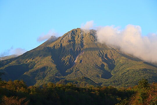
La Martinique Island , Montagne Pelée :
Weekly report from the Paris Institute of Earth Physics / Martinique Volcanological and Seismological Observatory, Saint-Pierre, April 10, 2026, 3:30 PM local time (GMT-4)
Between April 3, 2026, 4:00 PM UTC and April 10, 2026, 4:00 PM UTC, the Martinique Volcanological and Seismological Observatory recorded 125 volcanic earthquakes:
Among them, 7 have a magnitude (local magnitude Mlv or duration magnitude Md) greater than 0.5. The others are of lower energy. These earthquakes are located at depths between 0.8 and 4 km below the volcano’s summit. A significant number of these earthquakes originate from the well-known seismically active zones of Mount Pelée, located between 1.0 and 1.4 km below the volcano’s summit. This shallow volcano-tectonic seismicity is associated with microfracturing within the volcanic edifice, linked to the overall reactivation of the volcano observed since 2019.
No earthquakes have been felt by the local population.
The previous week, the OVSM recorded 17 volcanic earthquakes. As of April 10, 2026, and over the past four weeks, the OVSM has observed a total of 162 volcanic earthquakes, an average of 40 to 41 earthquakes per week.
During phases of volcanic reactivation of volcanoes similar to Mount Pelée, seismic activity of varying intensity and frequency is common. The probability of an eruptive activity in the short term remains low. However, based on observations accumulated in recent years, and particularly in recent months, a change in the situation in the medium term (weeks to months) cannot be ruled out.
For more details on observations and interpretations of volcanic activity over the longer term, please refer to the OVSM’s monthly bulletins.
The volcanic alert level, in accordance with the measures implemented by the authorities, is currently YELLOW: vigilance.
Source et photo : OVSM / IPGP.
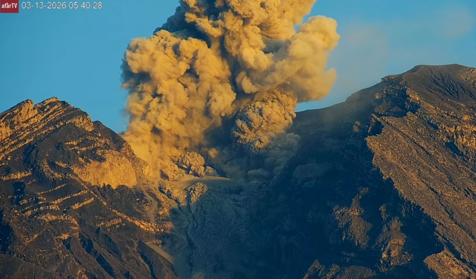
Indonesia , Semeru :
An eruption of Mount Semeru occurred on Saturday, April 11, 2026, at 8:47 PM WIB, with an observed ash column height of approximately 1500 m above the summit (approximately 5176 m above sea level). This ash column, white to gray in color, was highly intense and directed northwest. The eruption was recorded by a seismograph with a maximum amplitude of 22 mm and a duration of 241 seconds.
VOLCANO OBSERVATORY NOTICE FOR AVIATION – VONA
Issued : April 11 , 2026
Volcano : Semeru (263300)
Current Aviation Colour Code : ORANGE
Previous Aviation Colour Code : orange
Source : Semeru Volcano Observatory
Notice Number : 2026SMR723
Volcano Location : S 08 deg 06 min 29 sec E 112 deg 55 min 12 sec
Area : East java, Indonesia
Summit Elevation : 11763 FT (3676 M)
Volcanic Activity Summary :
Eruption with volcanic ash cloud at 13h47 UTC (20h47 local).
Volcanic Cloud Height :
Best estimate of ash-cloud top is around 16563 FT (5176 M) above sea level or 4800 FT (1500 M) above summit. May be higher than what can be observed clearly. Source of height data: ground observer.
Other Volcanic Cloud Information :
Ash cloud moving to northwest. Volcanic ash is observed to be white to gray. The intensity of volcanic ash is observed to be thick.
Remarks :
Eruption recorded on seismogram with maximum amplitude 22 mm and maximum duration 241 second.
Source : PVMBG.
Photo : Afar TV. Capture d’écran 2026-03-13
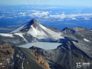
Colombia , Nevado del Ruiz :
Manizales, April 7, 2026, 4:50 PM
Regarding the monitoring of activity at the Nevado del Ruiz volcano, the Colombian Geological Survey (SGC), an agency under the Ministry of Mines and Energy, reports the following:
During the week of March 31 to April 6, 2026, the volcano continued to exhibit unstable behavior. Compared to the previous week, the main variations in some monitored parameters were as follows:
– Seismicity associated with fluid dynamics in the volcanic conduits remained stable in terms of the number of earthquakes and seismic energy released. These signals, corresponding to short-duration events, displayed low energy levels. During this week, no pulsatile ash emissions or variations in the apparent temperature of the emitted materials, associated with this type of seismic signal, were observed.
Seismic activity associated with rock fracturing processes within the volcanic edifice has decreased, both in the number of recorded events and in the seismic energy released.
The recorded earthquakes were of magnitude less than 1 and were located primarily in the Arenas crater and on the northwest, south-southeast, and northeast flanks of the volcano, within 4 km of the crater. To a lesser extent and in a more dispersed manner, earthquakes were also recorded on other flanks of the volcano, up to 12 km from the crater.

The depth of the events varied from less than 1 km to 8 km below the reference level.
The emission of water vapor and volcanic gases, primarily sulfur dioxide (SO₂), into the atmosphere from the Arenas crater was variable. The estimated SO₂ flux associated with degassing processes remained low and increased slightly compared to the previous week. These low values are partly due to wind direction and speed, which hampered measurements at the stations. Additional satellite monitoring also showed low levels of SO₂ emissions.
The height of the gas and water vapor column was generally less than 300 m (measured above the volcano’s summit), occasionally exceeding this height. However, the maximum reached was 1,000 m on April 5 at 9:44 PM. The direction of column dispersion was variable, tending toward the southeast, east-southeast, and southwest flanks of the volcano.
– Satellite monitoring of thermal anomalies at the bottom of the Arenas crater has shown that low-energy anomalies continue to be observed.
Source et photo : SGC.
Ecuador , Sangay :
DAILY REPORT ON THE STATE OF SANGAY VOLCANO, Saturday, April 11, 2026.
Geophysical Information Institute – EPN.
Surface Activity Level: High, Surface Trend: No Change
Internal Activity Level: Moderate, Internal Trend: No Change
Seismicity: From April 10, 2026, 11:00 AM to April 11, 2026, 11:00 AM:
Seismicity: Due to technical issues at the monitoring stations, the number of seismic events associated with the volcano is unavailable. The stations will be brought back online in the coming days.
Rainfall/Lahars:
No precipitation has been recorded in the volcano’s area. **In the event of heavy rain, this could remobilize the accumulated materials, generating mud and debris flows that would cascade down the volcano’s slopes and flow into nearby rivers.**
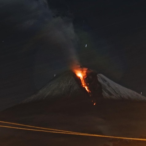
Emissions/Ash Column:
Since yesterday afternoon, the monitoring camera system has recorded several gas and ash emissions reaching altitudes below 1,100 meters above the crater, drifting west and west-northwest. The Washington VAAC also issued three reports of ash emissions reaching altitudes of 900 and 1,200 meters above the crater, drifting west and northwest.
Other Monitoring Parameters:
Over the past 24 hours, the FIRMS satellite system recorded one thermal anomaly, the MIROVA-MODIS satellite system one thermal anomaly, the MIROVA-VIIRS satellite system four thermal anomalies, and the MIROVA-SENTINEL satellite system one thermal anomaly.
Observation:
The volcano’s surface activity is high. However, the volcano remained mostly covered in clouds overnight and early this morning.
Alert level: Yellow
Source : IGEPN
Photo : david.ecua / FB. ( archive)