April 1 , 2026.
La Réunion Island , Piton de la Fournaise :
Press release from the Paris Institute of Earth Physics, Piton de la Fournaise Volcanological Observatory, April 1, 2026 – 9:30 a.m. local time – 5:30 a.m. UTC
Eruption in progress
Summary
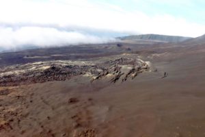
The eruption that began on February 13, 2026, resumed on March 28 at approximately 3:00 p.m. local time. Only one eruptive site is active on the south-southeast flank, at the cone formed between February 13 and March 25. Only the main southern flow is being fed again. Lava tube activity is well developed with numerous resurgences. At the eruptive cone, upbursts and some lava overflows have been observed. The eruptive tremor (an indicator of lava and gas flow) has been stable over the last 24 hours. Following the resumption of the eruption, we are observing an increase in seismicity as well as deflation of the volcano, indicating depressurization of the shallow magma chamber.
Observations at the various sites: After a pause observed between March 25 (4:30 PM local time) and March 28, the eruption, which began on February 13, 2026, on the south-southeast flank of the volcano, resumed on March 28 around 3:00 PM local time. At the eruptive site, the lava level at the cone is high, with active eddies and recurring lava overflows associated with the rising of gas bubbles. This degassing generally occurs intermittently, resulting in slight bursts of tremor on our recordings.
Lava tube activity continues downstream of the cone, with numerous resurgences visible in the lava field formed between February 13 and March 25, 2026. These resurgences are clearly visible in the Grandes Pentes area. Only the southern arm of the lava field is currently active along the main flow that reached the sea on March 16, as well as a secondary arm located south of the main flow, upstream of National Route 2.
Despite the current low or nonexistent lava flow to the platform, a weak gas plume is still present at the point where the lava enters the ocean, and its intensity depends on the amount of lava reaching the ocean. Explosions could also occur if the platform becomes destabilized. Indeed, this platform, composed of an accumulation of lava flows and rock fragments, remains very unstable and fragile. In the event of sudden destabilization, explosions of varying intensity could occur.
Instrumental Observations
The increase in seismicity is confirmed, with more than 90 shallow volcano-tectonic earthquakes recorded on March 31 (above sea level). These earthquakes are located in the summit area of the volcano, primarily along an annular fault situated directly beneath the shallow magma chamber (located approximately 1.5–2 km below the summit area).
Deflation of the summit area is occurring, indicating depressurization of the shallow magma reservoir. This parameter will need to be confirmed in the coming days.
The intensity of the eruptive tremor (an indicator of lava and gas flow) has been stable over the last 24 hours, with variations in amplitude likely indicating variations in the intensity of degassing.
Surface flow rates, estimated from satellite data via the HOTVOLC platform (OPGC – Clermont Auvergne University), have decreased slightly since yesterday, with values below 8 m³/s. It should be noted that depending on cloud cover, these estimates can vary significantly and become zero in the event of total cloud cover. Current lava tube activity also tends to underestimate the flow rates measured by satellite.
Alert Level 2.2
Source : OVPF / IPGP.
Photo : Volcanofan
Italy , Stromboli :
WEEKLY BULLETIN, March 23, 2026 to March 29, 2026. (Issuance date: March 31, 2026)
ACTIVITY SUMMARY
Based on monitoring data, the following points should be noted:
1) VOLCANOLOGICAL OBSERVATIONS: During this period, ordinary Strombolian-type eruptive activity was observed, interrupted by ejecta and two lava overflows from the North Crater area. The total hourly frequency fluctuated between high values (16 and 22 events/hour). The intensity of the explosions was mostly low to medium in the North and South Crater areas.
2) SEISMOLOGY: The monitored seismic parameters showed no significant variation.
3) GROUND DEFORMATION: GNSS network signals showed no significant variation. The tiltmeter network is out of service.
4) GEOCCHEMISTRY: Average SO₂ flux.
High CO₂ flux from the ground in the Pizzo area (STR02).
C/S ratio in the pen: average value.
Dissolved helium isotope ratio (R/Ra) in the thermal aquifer: data from the last sample taken on March 23, 2026, are high (R/Ra = 4.50).
CO₂ flux from the ground in the San Bartolo area: high to medium to high values.
CO₂ flux STR01: average value.
5) SATELLITE OBSERVATIONS: Satellite-observed thermal activity in the summit area was generally low, with some moderate thermal anomalies corresponding to the effusive episode that began on March 25, 2026, and ended on March 27, 2026.
VOLCANOLOGICAL OBSERVATIONS
During the observation period, Stromboli’s eruptive activity was characterized by analyzing images recorded by the INGV-OE monitoring cameras located at 190 m (SCT-SCV) and at Punta dei Corvi (SPCT). Explosive activity was primarily produced by five eruptive vents located in the northern zone of the crater and by at least two vents located in the central-southern zone. Due to unfavorable weather conditions on March 25, visibility from the crater terrace was insufficient for a precise description of the eruptive activity. On March 25 and 26, two lava flows were observed in the northern zone of the crater.
Observations of explosive activity captured by surveillance cameras:
Five active vents were observed in the North (N) area of the crater, two in sector N1 and three in sector N2. These vents produced low-intensity (less than 80 m high) and medium-intensity (less than 150 m high) explosive activity. In addition, low but continuous ejection activity was observed at the vents in sector N2. This activity was particularly intense on the morning of March 24. The eruptive products were mainly composed of coarse material (bombs and lapilli). The average frequency of explosions ranged from 15 to 19 events per hour.
Two main vents were observed in the Central-South (CS) crater area, which showed low- to medium-intensity explosions of fine material, sometimes mixed with coarse material. The average frequency of explosions ranged from less than one event per hour to three events per hour.
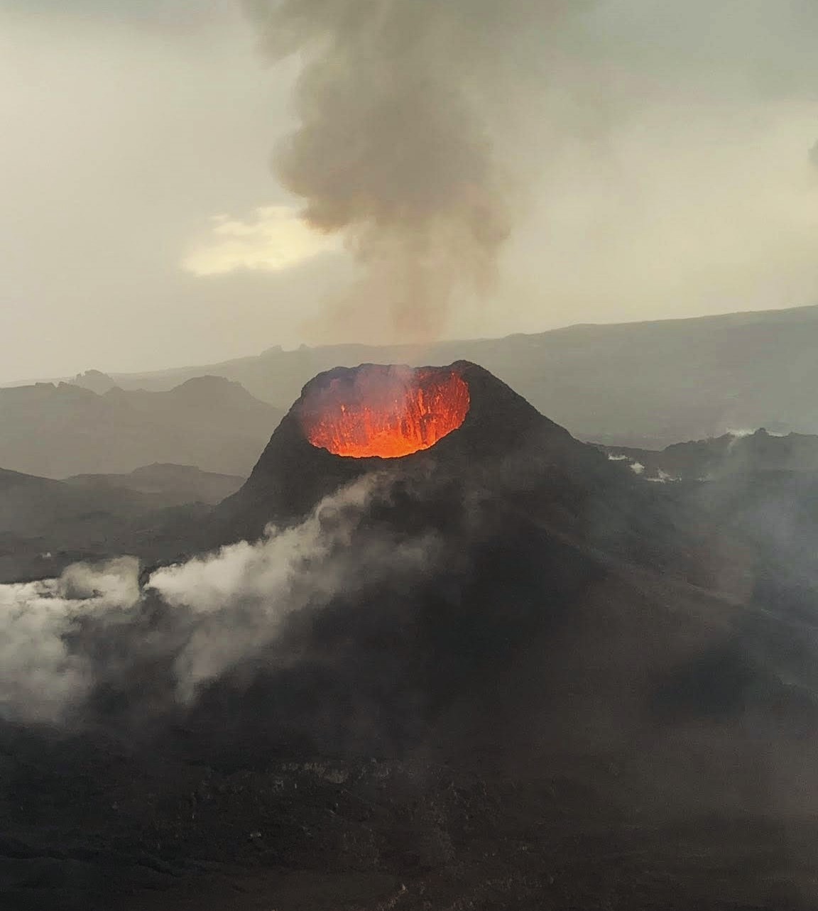
Lava overflows on March 25 and 26, 2026.
On March 25 and 26, two lava overflows occurred from the South vent of the North Crater, in sector N2, overlooking the Sciara del Fuoco. A description of these effusive events is provided below.
On March 25, due to cloud cover, it was not possible to determine the exact start of the lava overflow. However, initial images showed that at approximately 5:53 PM UTC, large blocks of incandescent material began to cascade down the upper part of the Sciara del Fuoco, entering the canyon formed in October 2023 and disappearing from the surveillance camera images. The lava flow extended to the upper-middle section of the Sciara and appeared to gain some feed later in the evening. On the 26th, late in the morning, a second lava flow began, parallel to the first. This flow extended for several hundred meters in the upper part of the Sciara, and by late evening, it seemed to be slowly feeding and cooling.
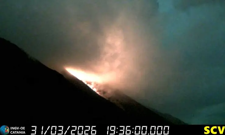
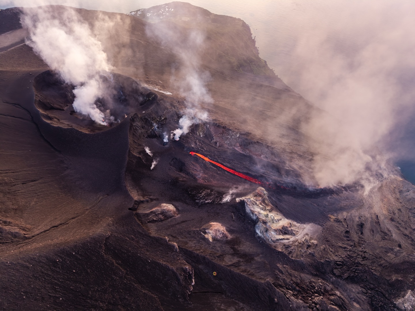
Stromboli Activity Update, March 31, 2026, 5:56 PM (3:56 PM UTC)
The National Institute of Geophysics and Volcanology, Osservatorio Etneo, reports that analysis of surveillance camera images reveals ongoing effusive activity due to lava overflows from the North Crater area. This activity is producing a moderate lava flow whose front is located in the upper part of the Sciara del Fuoco and is causing blocks to roll down the slope.
From a seismic perspective, since approximately 2:45 PM UTC today, the average amplitude of volcanic tremor has increased from moderate to high. No significant changes have been observed in the frequency and amplitude of explosion earthquakes. High-frequency GNSS network signals show no significant changes. Tilt-sensing network data are not currently available.
Further information will be released soon.
Source : INGV.
Photos : Stromboli stati d’animo / Sebastiano Cannavo , INGV.
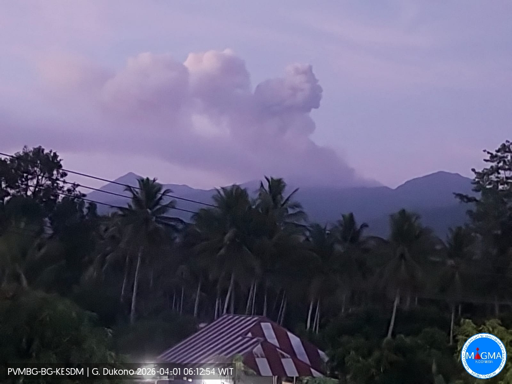
Indonesia , Dukono :
Mount Dukono experienced an eruption on Wednesday, April 1, 2026, at 5:59 AM WIT. An ash column was observed approximately 900 meters above the summit (at an altitude of about 1,987 meters). This column, white to gray in color, was highly intense and drifted eastward. At the time of writing, the eruption was still ongoing.
Seismic Observations
151 eruption earthquakes with amplitudes ranging from 9 to 34 mm and durations from 32.1 to 61.99 seconds.
One deep volcanic earthquake with an amplitude of 10 mm and a duration of 33.5 seconds.
One local tectonic earthquake with an amplitude of 7 mm and a duration of 30.63 seconds.
One distant tectonic earthquake with an amplitude of 6 mm and a duration of 35.9 seconds.
Continuous seismic tremor with an amplitude between 1 and 5 mm, predominantly 3 mm.
Recommendations
(1) Residents living near Mount Dukono and visitors/tourists are advised to refrain from any activity, climbing, or approaching the Malupang Warirang crater within a 4 km radius.
(2) Considering that eruptions with volcanic ash occur periodically and that the distribution Ash follows the direction and speed of the wind, so the area where the ash lands is not constant; people living around Mount Dukono are advised to always carry masks/face coverings and mouth coverings to use as needed to avoid the threat that volcanic ash poses to the respiratory system.
Source et photo : PVMBG.
Guatemala , Fuego :
Weather conditions: Partly cloudy
Wind: West
Rainfall: 24.8 mm
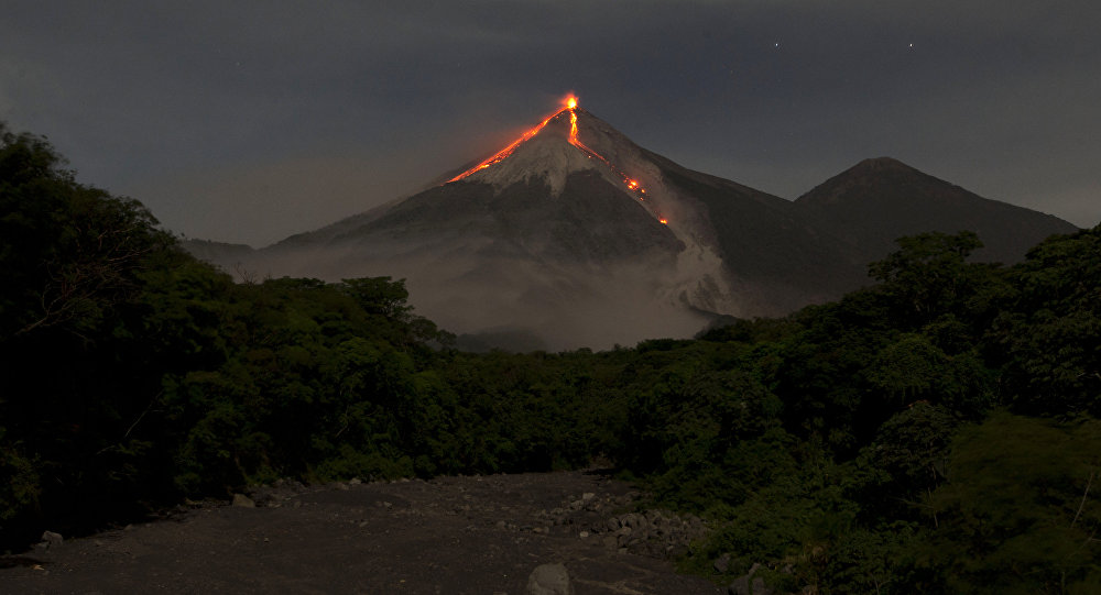
Activity
During the night and early morning, weak to moderate degassing was recorded, with fumaroles reaching approximately 400 meters above the crater and dispersing eastward. Explosive activity continued with 8 to 13 weak to moderate explosions per hour, generating ash plumes between 4,500 and 4,800 meters in altitude, which drifted eastward and southeastward. Some explosions were accompanied by rumbling, shock waves, and brief noises similar to those of locomotives, associated with the continued expulsion of gas. Incandescent pulsations up to 300 meters above the crater were observed, accompanied by small avalanches. In addition, incandescent materials fell back around the crater, flowing towards the ravines of Ceniza, Taniluyá, Seca, Santa Teresa, Trinidad and Las Lajas, sometimes reaching the vegetation line.
Source : Insivumeh
Photo : Moises Castillo .
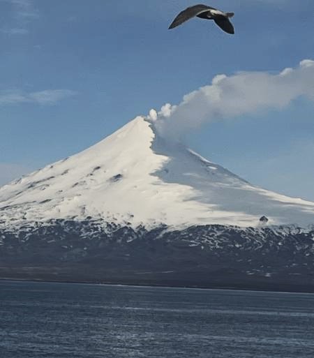
Alaska , Shishaldin :
Unrest continues at Shishaldin Volcano. Seismic and infrasound activity remains elevated, with numerous small earthquakes, seismic tremor, and infrasound signals observed over the past day. Sulfur dioxide emissions drifting to the southeast were detected in satellite data. Steam emissions were observed in webcam images but nothing was observed in satellite views of the volcano.
Local seismic and infrasound sensors, web cameras, and a geodetic network are used to monitor Shishaldin Volcano. In addition to the local monitoring network, AVO uses nearby geophysical networks, regional infrasound and lightning data, and satellite images to detect eruptions.
Source : AVO
Photo : Cauley, Marc