June 3 , 2026.
Indonesia , Bur Ni Telong :
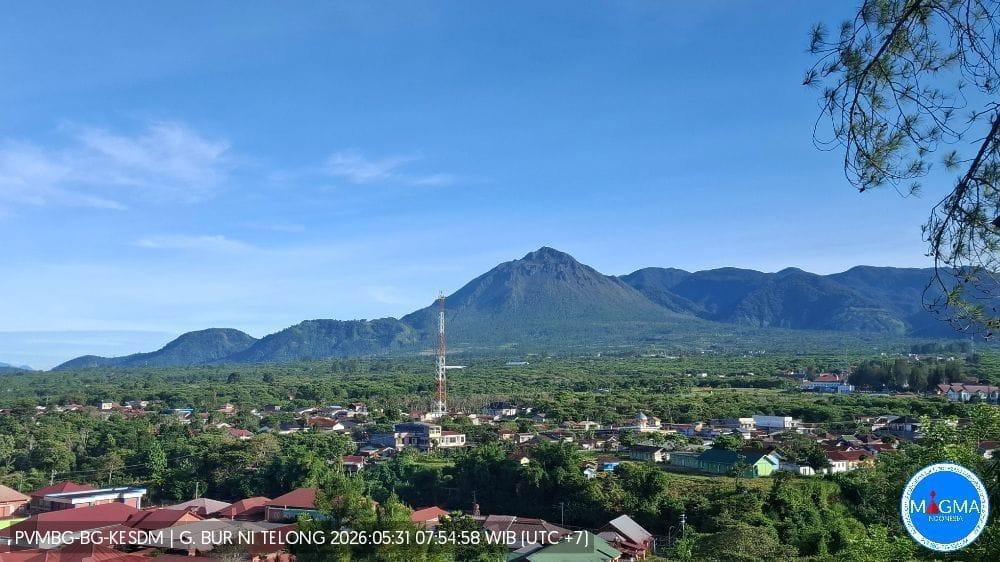
REDUCTION OF THE SAFETY ZONE RADIUS FOR MOUNT BUR NI TELONG, ACEH, JUNE 1, 2026
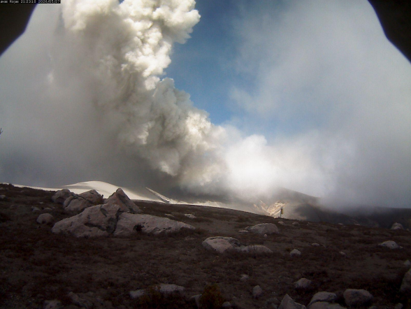
Bur Ni Telong volcano is a stratovolcano reaching an altitude of 2,624 meters, located at coordinates 96° 49′ 16″ East longitude and 4° 46′ 10″ North latitude. It is administratively located in the Bener Meriah Regency, Aceh Province. On January 3, 2026, the activity level of Mount Bur Ni Telong was lowered from Level III (Siaga) to Level II (Waspada), with a recommendation for the public, visitors, and climbers to stay within a 3-kilometer radius of the crater.
To date, no ash emissions have been observed at the crater of Mount Bur Ni Telong. Seismic activity began to fluctuate in March 2026 and has decreased since mid-May 2026. The number of recorded deep volcanic earthquakes (SVs) has dropped from an average of 6 per day to 3 per day. However, vigilance remains necessary due to the risk of felt earthquakes, as the epicenter is located near Mount Bur Ni Telong. Consequently, the activity level of Mount Bur Ni Telong remains at Level II (Waspada), but with a reduced danger radius.
The potential hazard at this time could be an eruption triggered by a tectonic earthquake around Mount Bur Ni Telong or a phreatic eruption without a significant increase in seismicity. Another potential hazard is the release of volcanic gases in the area of vents and fumaroles, which can be dangerous if inhaled gas concentrations exceed safety thresholds.
Based on visual and instrumental observations, the activity level of Mount Bur Ni Telong remains at Level II (Waspada) as of June 1, 2026. The public and visitors/climbers are advised to stay within a 2 km radius of the crater and to avoid fumarole and solfatara areas during cloudy or rainy weather due to the potential hazards associated with gas concentrations. The public is urged to remain vigilant for any potential increase in seismic activity.
Source et photo : PVMBG.
Colombia , Puracé – Los Coconucos volcanic chain :
Popayán, June 2, 2026, 3:30 PM
Regarding the monitoring of activity at the Puracé volcano and the Los Coconucos volcanic chain, the Colombian Geological Survey (SGC), an agency under the Ministry of Mines and Energy, reports the following:
During the week of May 26 to June 1, 2026, variations in seismic activity were observed, linked to an increase in the energy of continuous tremor (CT) located beneath the craters of the Puracé and Piocollo volcanoes, at depths of less than 3 km.
This seismicity was associated with fluid circulation processes, the release of volcanic gases, and ash emissions into the atmosphere from the Puracé volcano crater. Due to this increased activity, ash emissions were observed, with plumes reaching a height of approximately 2 km above the volcano’s summit, although not exceeding the heights observed the previous week. These emissions dispersed primarily to the west and northwest of the crater, following the prevailing wind direction. This resulted in reports of ashfall in several rural areas of the municipality of Puracé, including Hato Viejo, Ambiró, Pululó, Tabío, Hispala, Chapío, Cristales, Cobaló, 20 de Julio, Anambío, Pisanrabo, San Juan, Río Negro, and the municipal capital, Coconuco. Reports were also received from some neighborhoods in the city of Popayán.
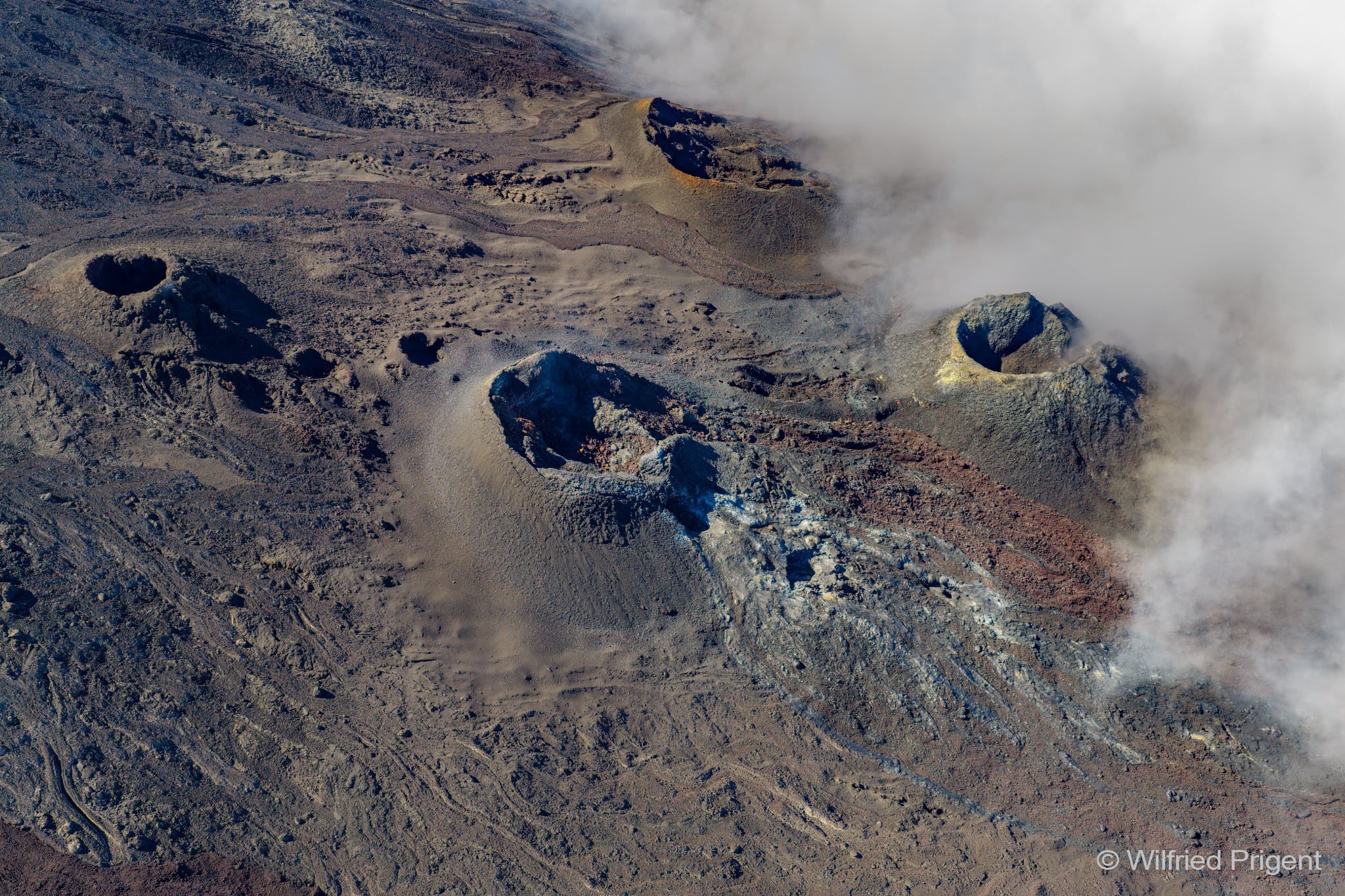
Recording from the Lavas Rojas camera, located 2.4 km northwest of the Puracé volcano, showing ash emission on May 27, 2026, at 4:23 PM.
Fracture seismicity remained stable compared to the previous week, both in terms of the number of earthquakes and the seismic energy released. It was primarily located between the Puracé and Piocollo volcanoes, at depths of 1 to 3 km, with magnitudes less than 1. Images captured by satellite sensors and visible and infrared webcams continued to show thermal anomalies inside the Puracé volcano crater and in the fumarole field on its outer rim, as well as degassing activity in the Puracé and Curiquinga volcano craters. High emissions of sulfur dioxide (SO₂) into the atmosphere also continued. Furthermore, a slight increase in the deformation rate was detected in the area between the Puracé, Piocollo, and Curiquinga volcanoes.
In conclusion, the variations observed at the Puracé volcano—part of the Los Coconucos volcanic chain—indicate that the system continues to evolve and that further ash emissions and fallout are possible, dispersed according to the prevailing wind direction. The public is advised to refrain from climbing to the summits of the volcanic chain and to remain attentive to official bulletins from the Geological Survey of Colombia (SGC).
Source et photo : SGC.
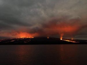
La Réunion , Piton de la Fournaise :
Seismicity
In May 2026, the OVPF-IPGP recorded the following total seismic activity at the Piton de la Fournaise massif:
• 29 shallow volcano-tectonic earthquakes (0.2 to 1.5 km above sea level), mostly beneath the Bory and Dolomieu summit craters;
• 150 deep earthquakes (below sea level);
• 14 long-period earthquakes;
• 695 rockfalls or collapses.
May 2026 was primarily marked by deep seismicity, with 150 volcano-tectonic earthquakes located between 6 and 8 km below sea level, west of the summit of Piton de la Fournaise. The evolution of the seismicity rate from the handrail seems to vary more strongly than that obtained from automatic detections by template matching, which appears to be linked to an observational bias.
Only 29 shallow volcano-tectonic earthquakes were detected, with only one event located beneath the Dolomieu crater.
Numerous rockfalls were also observed (695 events). As is usually the case, these rockfalls are partly located at the summit of Piton de la Fournaise and the Rivière de l’Est fault, but also at the eruptive cones and recently emplaced lava flows on the east-southeast flank of Piton de la Fournaise. These events likely correspond to the collapse of cones and lava tubes. The signals classified as long-period are also largely located at the site of older eruptive cones. The long period nature of these signals may result either from the propagation effects of elastic waves in poorly consolidated media (e.g., Bean et al., 2008) or from changes in the hydrothermal system near the eruptive site (Zecevic et al., 2013).
Observations
Following the cessation of the eruption on April 12, 2026, slight inflation of the edifice was again recorded, with a noticeable slowdown beginning in late April. Since late May, this inflation appears to have ceased. This parameter will be confirmed next month.
Stress maps show that, from the beginning of May, the elongation is eccentric to the west.
Source : OVPF.
Photo : Wilfried Prigent / ovpf/FB.
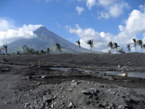
Guatemala , Santiaguito :
Atmospheric conditions: Clear skies
Wind: Northeast
Rainfall: 17.5 mm
Activity
The Santiaguito Volcanological Observatory reports favorable conditions for observing the dome.
Weak to moderate explosions are reported at a rate of 1 to 3 per hour, projecting columns of gas and ash up to 900 meters high. These columns are drifting southwest due to the wind. Incandescence is visible on the dome, as well as the detachment of incandescent rock blocks to the west, southwest, and south. Ashfall is possible in San Marcos Palajunoj, Loma Linda, and the surrounding areas due to the wind direction.
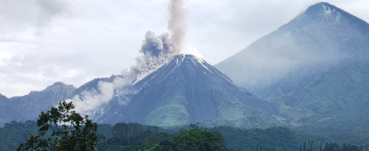
Due to the significant accumulation of rock material, the Caliente dome and the promontory overlooking the lava flow are at risk of collapsing, generating long-range pyroclastic flows to the southwest. Therefore, the recommendations of Special Bulletin BESAN-016-2026 should be followed.
Source : Insivumeh .
Photo : Conred .
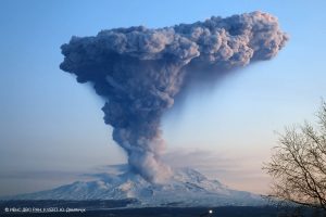
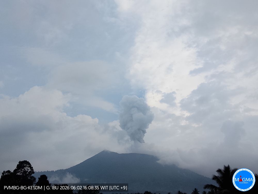
Indonesia , Ibu :
An eruption of Mount Ibu occurred on Tuesday, June 2, 2026, at 7:00 PM WIT, with an observed ash column height of approximately 500 m above the summit (approximately 1825 m above sea level). This column was white to gray in color, of moderate to strong intensity, and directed northeast. At the time of writing, the eruption was still ongoing.
Seismicity Observations
126 eruption earthquakes with amplitudes between 15 and 28 mm and durations of 33 to 68 seconds.
1 emission earthquake with an amplitude of 4 mm and a duration of 34 seconds.
13 harmonic tremors with amplitudes between 2 and 28 mm and durations of 34 to 146 seconds.
109 low-frequency earthquakes with amplitudes between 2 and 10 mm and durations of 17 to 29 seconds.
136 shallow volcanic earthquakes with amplitudes between 2 and 6 mm and durations of 7 to 21 seconds.
1 deep volcanic earthquake with an amplitude of 2 mm and a duration of 23 seconds. Fifteen distant tectonic earthquakes, ranging in magnitude from 2 to 28 mm, with no observed shock waves and durations of 34 to 95 seconds, were recorded.
Recommendations
1. Residents living around Mount Ibu and visitors/tourists are advised to refrain from all activities within a 2 km radius and a 3.5 km sector around the crater opening in the northern part of the active Mount Ibu crater.
2. In the event of ashfall, people engaging in outdoor activities are advised to wear a mask covering their nose, mouth, and eyes, as well as protective eyewear.
Source et photo : PVMBG.