June 2 , 2026.
Hawaii , Kilauea :
HAWAIIAN VOLCANO OBSERVATORY STATUS REPORT , U.S. Geological Survey
Monday, June 1, 2026, 3:11 PM HST (Tuesday, June 2, 2026, 01:11 UTC)
19°25’16 » N 155°17’13 » W,
Summit Elevation 4091 ft (1247 m)
Current Volcano Alert Level: ADVISORY
Current Aviation Color Code: YELLOW
Summary:
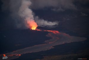
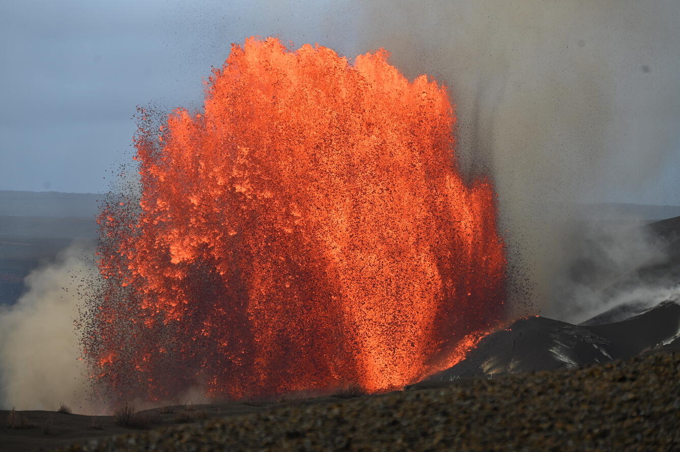
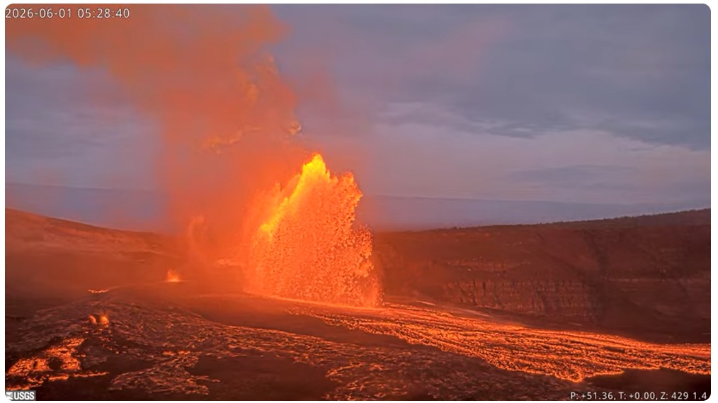
Episode 48 of the ongoing Halemaʻumaʻu eruption at the summit of Kīlauea ended abruptly at 1:37 p.m. HST on June 1. The eruption is currently paused.
Activity Summary:
Episode 48 of the ongoing Halemaʻumaʻu eruption at the summit of Kīlauea ended abruptly at 1:37 p.m. HST on June 1, 2026, after 9 hours of continuous lava fountaining from the north vent. The eruption is currently paused.
The Halemaʻumaʻu eruption now has the most fountaining episodes ever recorded for an episodic fountaining eruption, edging out the Pu‘u‘ō‘ō eruption which had 47 fountain episodes. Other eruptions have had additional episodes related to changes in vent activity and location, this only applies to episodic fountains.
Most tephra fell within the closed area of Hawaiʻi Volcanoes National Park, but sparse reticulite up to 1 inch (2 centimeters) in size fell at both the Uēkahuna overlook and on Highway 11 west of Nāmakanipaio campground. Fine ash and Peleʻs hair was reported from Hawaiʻi Volcanoes National Park in communities to the northeast, including Mauna Loa Estates, Ohia Estates, Volcano village, and Royal Hawaiian Estates.
Episode 48 Chronology:
Lava fountaining episode 48 in Halemaʻumaʻu at the summit of Kīlauea began at 4:40 a.m. HST on June 1 and stopped abruptly at 1:37 p.m. HST on June 1, after just under 9 hours of continuous fountaining from the north vent. The last minute was marked by gas jetting at the north vent. The south vent never fountained during this episode, but it periodically spattered and had a few episodes of jetting. The instantaneous effusion rate peaked at about 415 cubic yards (320 cubic meters) per second just before 6:00 a.m. HST, with an average effusion rate of 245 cubic yards (185 cubic meters) per second for the entire fountaining episode. An estimated 7.3 million cubic yards (5.6 million cubic meters) of lava erupted and covered about 40% of the Halemaʻumaʻu crater floor. The Uēkahuna tiltmeter (UWD) recorded about 17.1 microradians of deflationary tilt during episode 48.
Episode 48 lava fountaining began approximately 35 hours after the onset of precursory lava overflows at 5:41 p.m. HST in the evening of May 30. These continued throughout the next day and were amazingly uniform in duration (5-10 minutes) and interval (15-30 minutes). There were 95 precursory overflows erupted only from the south vent, though spattering was visible at the north vent throughout most of this time. North vent spattering preceded the overflows starting with 2 very small spatter events on the evening of May 27. No additional spatter was visible until the evening of May 28, when the north vent began sporadic spattering that continued until the north vent overflowed at 3:46 a.m. HST June 1. North vent dome fountaining then steadily escalated in vigor and height until it transitioned to episode 48 fountaining at 4:40 a.m. HST June. After the north vent became active, the south vent continued overflowing cyclically, but over the next hour its activity diminished to only spattering as the north vent fountains grew. Meanwhile, the north vent lava fountain grew steadily until reaching a maximum height of around 650 feet (200 meters) by about 5:50 a.m. HST. Over the next several hours the fountain height gradually declined, and it was estimated under 300 feet (90 meters) high about 1 hour before the episode ended at 1:37 p.m. HST on June 1.
The north vent lava fountain produced significant heat and ash, feeding a plume that reached a maximum height of about 25,000 feet (7,600 meters) above sea level based on radar data reported by the National Weather Service and Washington Volcanic Ash Advisory Center. At first, lower-level trade winds from the northeast pushed most tephra from the lava fountaining to the southwest of Halemaʻumaʻu. As the plume cloud grew, winds from the south at higher elevations between 10,000 feet and 20,000 began moving the plume northward. This allowed tephra to spread out and fall at a number of locations around the rim of Kaluapele (Kīlauea caldera). At 5:31 a.m. HST, the National Weather Service issued an ashfall advisory for the southeast and northeast of Island of Hawaiʻi, including Hawaiʻi Volcanoes National Park. Sparse pumice up to 1-2 inches (2-5 centimeters) in size fell at the Uēkahuna overlook and Nāmakanipaio campground along with Highway 11 west to the 34-mile marker. Fine ash and Peleʻs hair were deposited around Kīlauea Visitor Center and outside Hawaiʻi Volcanoes National Park in communities to the northeast, including Mauna Loa Estates, Ohia Estates, and Volcano village as well as to the west of the caldera between the 34- and 36-mile markers. Very sparse, fine ash was reported as far as Mountain View. A commercial pilot reported a sulfur and ash cloud off of Laupāhoehoe that resulted in cancellations and diversions of several morning flights to Hilo.
A small swarm of earthquakes along the southwest side of Halemaʻumaʻu crater just preceded the end of episode 48. The earthquakes began around 12:15 and have continued sporadically for several hours following the end of episode 48. There were approximately 15 locatable earthquakes varying from just under magnitude 1 to magnitude 2.2. Three of the earthquakes were magnitude 2 or greater, 8 were between magnitude 1 and 2 and 4 were less than magnitude 1. The earthquakes had no visible impact on the eruption or Halemaʻumaʻu crater.
Source : HVO.
Photos : USGS/ L. Gallant , USGS.
Iceland , Mosfellsheiði :
A strong earthquake struck southwest Iceland at 1:45 p.m. today.
The earthquake originated on Mosfellsheiði, a short distance north of the turnoff from Suðurlandsvegur Road to Þrengsli.
400 earthquakes recorded in Hellisheiði seismic swarm
According to preliminary measurements from the Icelandic Meteorological Office, the earthquake measured magnitude 4.5. It is also estimated to have occurred at a depth of approximately 4.5 kilometers.
Several aftershocks have since been recorded.
Follows intense seismic activity
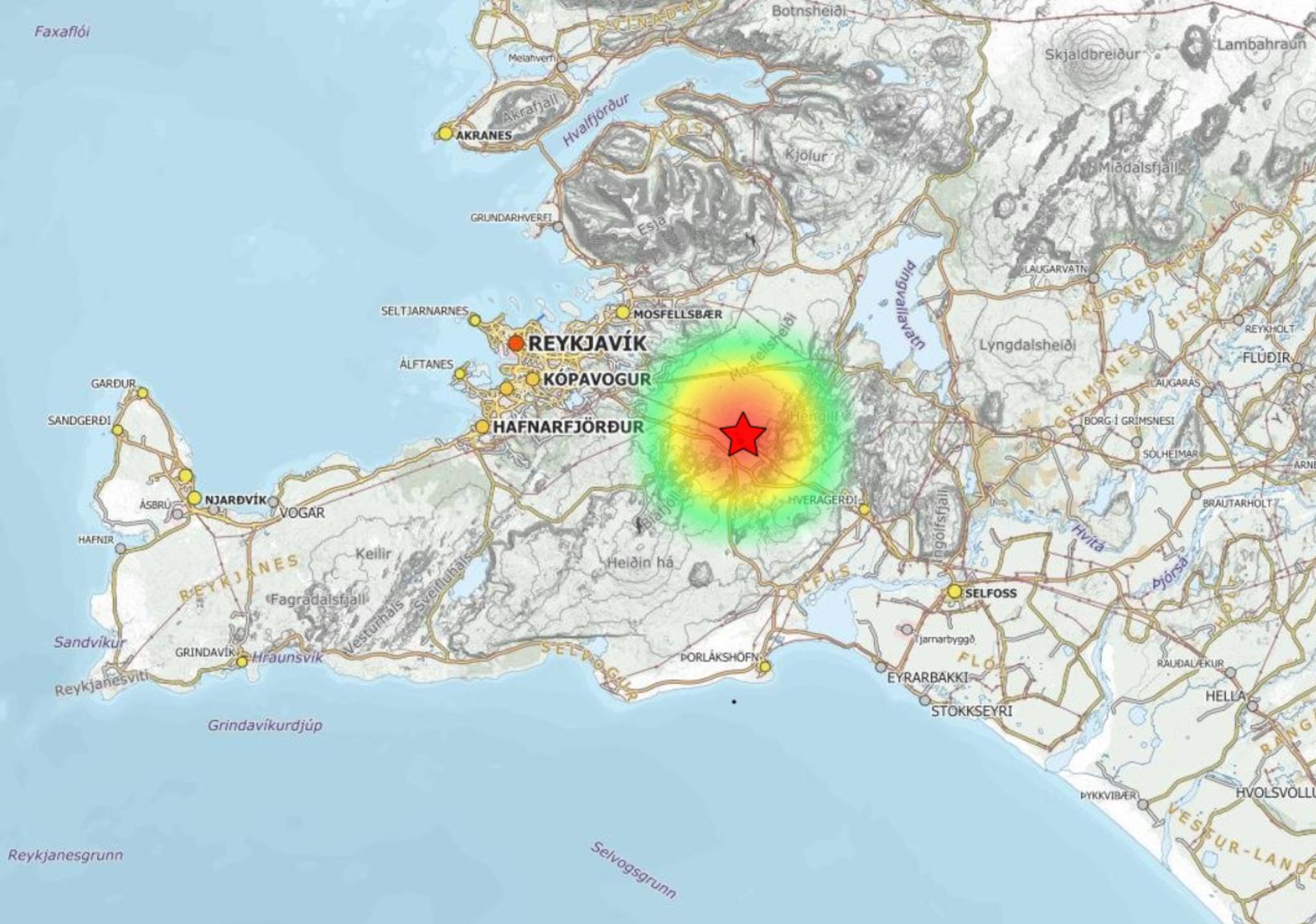
The earthquake comes on the heels of a significant seismic swarm that affected the area over the weekend.
According to Elísabet Pálmadóttir, a natural hazards specialist at the Icelandic Meteorological Office, the quake was widely felt across southwest Iceland. The Meteorological Office has received reports from Hveragerði, Selfoss, and the Capital Region indicating that residents clearly felt the tremor.
Source : icelandmonitor mbl / is
United-States , Yellowstone :
YELLOWSTONE VOLCANO OBSERVATORY MONTHLY UPDATE , U.S. Geological Survey
Monday, June 1, 2026, 10:55 AM MDT (Monday, June 1, 2026, 16:55 UTC)
44°25’48 » N 110°40’12 » W,
Summit Elevation 9203 ft (2805 m)
Current Volcano Alert Level: NORMAL
Current Aviation Color Code: GREEN
Summary
Yellowstone Caldera activity remains at background levels, with 45 located earthquakes in May (largest = M2.0). Deformation measurements indicate no significant uplift or subsidence of the caldera or north caldera rim since January 2026.
Recent Work and News
Echinus Geyser, in Norris Geyser Basin, remained active, with 2 eruptions in May. The month also included eruptions of Black Diamond Pool in Biscuit Basin (site of a hydrothermal explosion in 2024) that were recorded by acoustic, seismic, and temperature measurements on May 5 and 11. The biennial coordination meeting of the Yellowstone Volcano Observatory took place during May 18-20 at Mammoth Hot Springs, with discussions focusing on how to update geologic maps of the park and better anticipate and detect hazardous hydrothermal events. Field work included the seasonal deployment of semipermanent GPS stations, which are temporary GPS sites that are set up every May and recovered in September/October and serve to densify the ground deformation monitoring network during summer months.
Seismicity
During May 2026, the University of Utah Seismograph Stations, responsible for the operation and analysis of the Yellowstone Seismic Network, located 45 earthquakes in the Yellowstone National Park region. The largest event of the month was a microearthquake of magnitude 2.0 located about 20 miles south-southeast of Mammoth Hot Springs in Yellowstone National Park on May 21 at 11:08 p.m. MDT.
There were no swarms identified during May.
Earthquake activity in Yellowstone is at background levels.
Ground Deformation
Data from continuous GPS stations indicate little net deformation in the region since January 2026. The uplift that started in July 2025 on the north caldera rim ceased by mid-January 2026, and there has been no uplift or subsidence of Yellowstone Caldera since December 2025.
Source : YVO
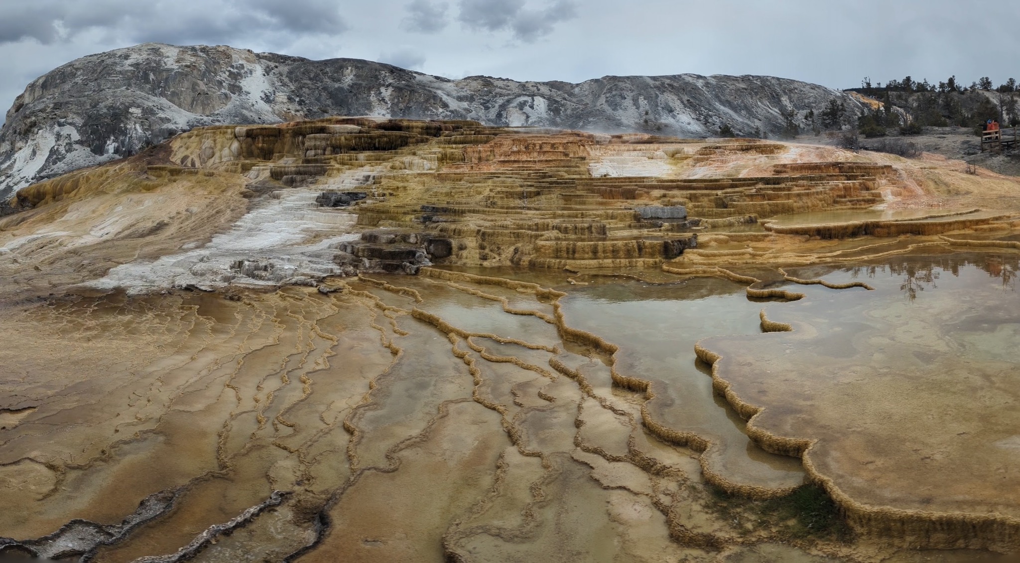
Photo : Mound Terrace, Mammoth Hot Springs, 20 Mai 2026.
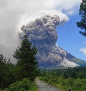
Indonesia , Lewotobi Laki-laki :
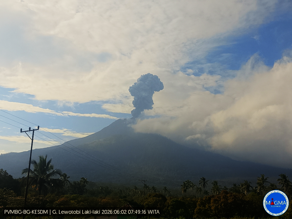
An eruption of Mount Lewotobi Laki-laki occurred on Tuesday, June 2, 2026, at 7:47 AM WITA. The observed ash column rose approximately 1,000 meters above the summit (about 2,584 meters above sea level). This gray ash column was highly intense and drifted southwest and west. The eruption was recorded by a seismograph, with a maximum amplitude of 11 mm and a duration of 148 seconds.
VOLCANO OBSERVATORY NOTICE FOR AVIATION – VONA
Issued : June 2 , 2026
Volcano : Lewotobi Laki-laki (264180)
Current Aviation Colour Code : ORANGE
Previous Aviation Colour Code : orange
Source : Lewotobi Laki-laki Volcano Observatory
Notice Number : 2026LWK039
Volcano Location : S 08 deg 32 min 20 sec E 122 deg 46 min 06 sec
Area : East Nusa Tenggara, Indonesia
Summit Elevation : 5069 FT (1584 M)
Volcanic Activity Summary :
Eruption with volcanic ash cloud at 23h47 UTC (07h47 local).
Volcanic Cloud Height :
Best estimate of ash-cloud top is around 8269 FT (2584 M) above sea level or 3200 FT (1000 M) above summit. May be higher than what can be observed clearly. Source of height data: ground observer.
Other Volcanic Cloud Information :
Ash cloud moving from southwest to west. Volcanic ash is observed to be gray. The intensity of volcanic ash is observed to be thick.
Remarks :
Eruption recorded on seismogram with maximum amplitude 11 mm and maximum duration 148 second.
Source et photo : PVMBG.
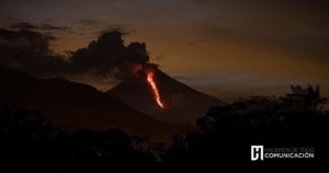
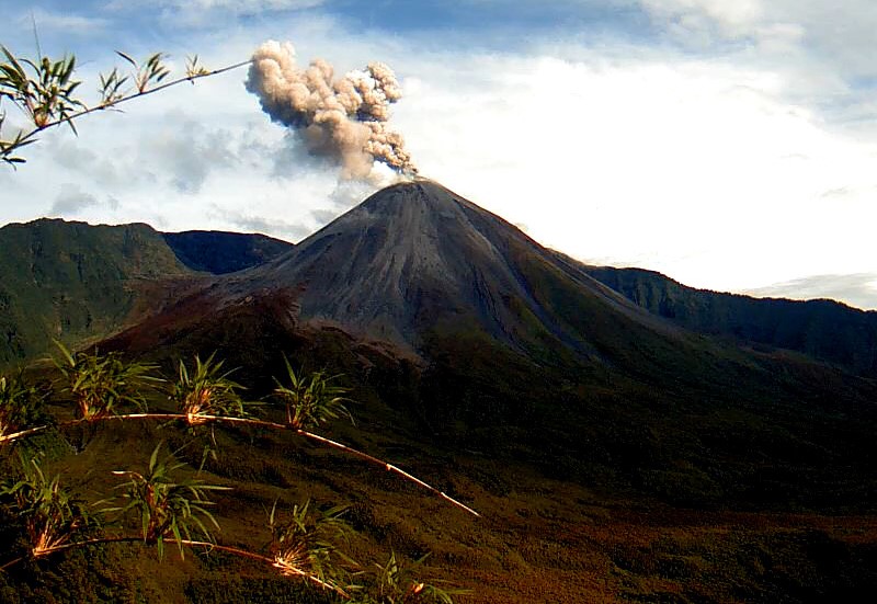
Ecuador , El Reventador :
REVENTADOR VOLCANO DAILY STATE REPORT, Monday, June 1, 2026.
Geophysical Information Institute – EPN.
Surface Activity Level: High, Surface Trend: No Change
Internal Activity Level: Moderate, Internal Trend: No Change
From May 31, 2026, 11:00 AM to June 1, 2026, 11:00 AM:
Seismicity:
Explosive (EXP) 78
Long Period (LP) 7
Emission Tremor (TREMI) 4
Harmonic Tremor (TRARM) 2
Rainfall/Lahars:
Rainfall was recorded in the volcano area, but it did not generate mudflows or debris. **In the event of heavy rainfall, accumulated material could be remobilized, causing mudflows and debris flows that would cascade down the volcano’s flanks and into nearby rivers.**
Ash Plume:
Due to weather conditions, no ash emissions were observed via the monitoring camera system or GOES-19 satellite imagery.
Furthermore, the Washington VAAC agency did not report any ash emissions.
Other Monitoring Parameters:
The MIROVA-VIIRS 375 satellite system recorded a thermal anomaly in the last 24 hours.
Observation:
Overnight, incandescent material was observed descending to a depth of 900 meters below the crater rim. At the time of publication, the volcano remains shrouded in clouds.
Alert Level – SGR: Orange
Source et photo : IGEPN.