May 15 , 2026.
Hawaii , Kilauea :
HVO/USGS Volcanic Activity Notice
Current Volcano Alert Level: WATCH
Current Aviation Color Code: ORANGE
Issued: Thursday, May 14, 2026, 5:18 PM HST
Source: Hawaiian Volcano Observatory
Notice Number: 2026/H229
Location: N 19 deg 25 min W 155 deg 17 min
Elevation: 4091 ft (1247 m)
Area: Hawaii
Summary:
Episode 47 of the ongoing Halemaʻumaʻu eruption continues as of 5:00 p.m. HST on May 14.
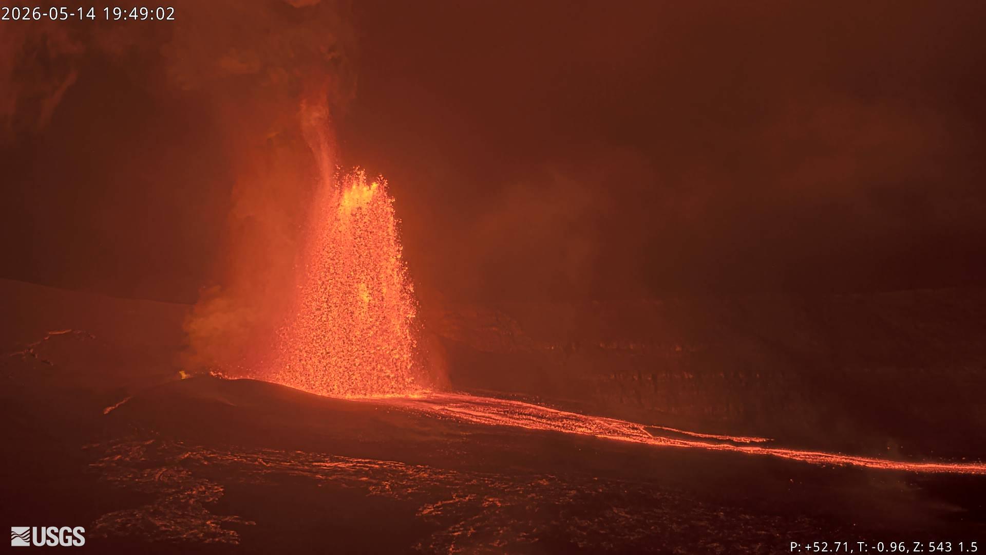
Volcanic Activity:
Lava fountaining episode 47 in Halemaʻumaʻu at the summit of Kīlauea began at 3:27 p.m. HST on May 14 and continues as of this notice. Fountaining activity has been focused at the north vent, though the south vent has been spattering periodically.
The National Weather Service reports that the plume from this eruption is reaching 20,000 feet above sea level. Ground-level sensors near the eruptive vents indicate that low-altitude winds are blowing from the northeast direction, which indicates that most volcanic gas emissions and volcanic material will distributed to the southwest of Halemaʻumaʻu. However, the National Weather Service reports that higher-altitude winds are blowing from the southwest direction above 15,000 feet above sea level, suggesting that light tephra fallout is possible to the northeast of Kīlauea summit.
All eruptive vents and lava flows are confined to Halemaʻumaʻu crater within Hawaiʻi Volcanoes National Park. Tephra fall from volcanic ash clouds is greatest within 3 miles (5 km) of the vents, lighter ash and Pele’s Hair may stay suspended for large distances from the vents.
Source et photo : HVO
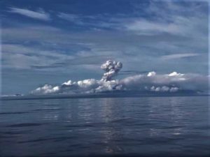
Bismarck Sea , South of Rambutyo :
A new eruption began on 8 May in the Central Bismarck Sea, in an area about 82 km S of Rambutyo Island and 125 km SE of Manus Island, around 16 km SE of the approximated location of a submarine eruption detected by instruments in 1972. According to the Rabaul Volcano Observatory (RVO), seismic events recorded on 31 March and 25 April were followed by a swarm with six events on 8 May, likely indicating the start of the eruption. Gas-and-steam plumes that sometimes appeared voluminous were visible in satellite data during 9-12 May rising as high as 3 km (10,000 ft) a.s.l. and drifting W and NW. Plumes of discolored water were also observed drifting away from the origin point of the steam plumes. Infrared Moderate Resolution Imaging Spectroradiometer (MODIS) data triggered a small cluster of MODVOLC thermal alerts during 9-12 May. According to RVO, steam plumes were less vigorous during 13-14 May and drifted W and NW. Thermal anomalies (last detected on 12 May) and photos taken from a local fishing boat hinted at the formation of a shallow volcanic reef, though it was unconfirmed.
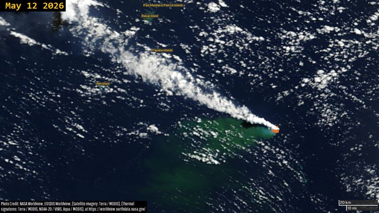
SOFAR signals resembling those produced at known submarine eruptions were recorded in January 1972 in the central Bismarck Sea (Johnson et al., 1981). The source of the signals was at the junction of two segments of the N margin of the South Bismarck plate. The more easterly of these segments is a transform fault, whereas the more westerly is an area of oblique active seafloor spreading. The signals were detected by a seismic station on nearby Manus Island, as well as at hydrophone stations on Wake and Midway Islands in the central Pacific.
Sources: Rabaul Volcano Observatory (RVO), Darwin Volcanic Ash Advisory Centre (VAAC), Sentinel Hub, NASA MODIS Rapid Response System, Dr. Philipp A. Brandl, GEOMAR Helmholtz Centre for Ocean Research Kiel , GVP.
Photo : Worldview earthdata nasa .
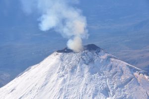
Philippines , Mayon :
The Philippine Institute of Volcanology and Seismology (PHIVOLCS) reported that the eruption at Mayon continued during 7-12 May, characterized by lava effusion, pyroclastic density currents (PDCs), incandescent rockfalls, ash-and-gas plumes, and occasional minor Strombolian activity. Emissions were visible almost daily, rising as high as 1.3 km above the summit and drifting mainly WNW, W, WSW, and SW. Each day the seismic network recorded 290-350 rockfalls, 2-12 PDCs, and 11-35 volcanic earthquakes. The earthquake counts included 3-26 daily periods of volcanic tremor, each lasting between one minute to two hours and 13 minutes. Daily measurements of sulfur dioxide emissions averaged 1,295-2,785 tonnes per day. The lava flows did not advance in the Basud (E) and Bonga (SE) drainages, remaining 3.8 and 3.2 km long, respectively. New lava flows began filling the upper SW flank gully in the Mi-isi drainage, created by the large PDCs from collapses on 2 May. The lava-flow length alternated between 1.6 and 1.3 km long during 7-10 May as the flows collapsed or partially collapsed and advanced. A PDC from a lava flow collapse in the Bonga drainage occurred at 14h28 on 8 May. A few short periods of lava fountaining were recorded during 8-9 and 12 May.
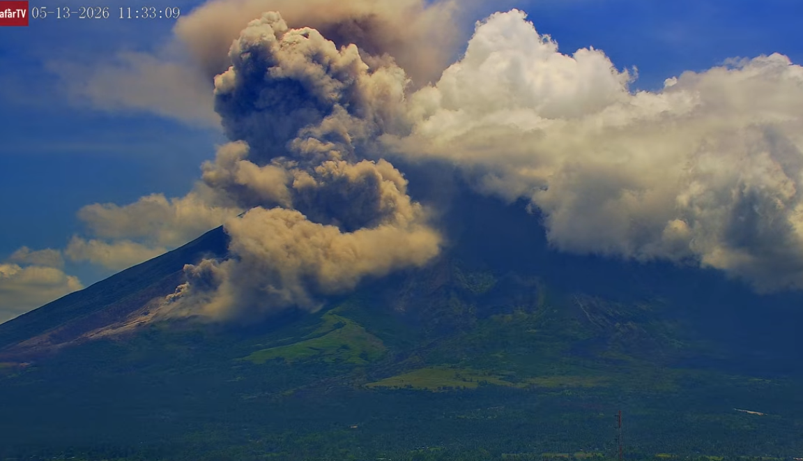
The number of evacuees was relatively stable; by 18h00 on 11 May a total of 4,020 people (1,103 families) were staying in 12 evacuation shelters, and an additional 89 people (27 families) were staying with friends or relatives, according to the Disaster Response Operations Monitoring and Information Center (DROMIC). The Alert Level remained at 3 (on a 0-5 scale) and residents were reminded to stay away from the 6-km-radius Permanent Danger Zone (PDZ). PHIVOLCS recommended that civil aviation authorities advise pilots to avoid flying close to the summit.
Sources: Philippine Institute of Volcanology and Seismology (PHIVOLCS), Disaster Response Operations Monitoring and Information Center (DROMIC) , GVP.
Photo : Afar TV.
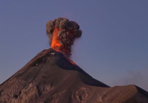
Japan , Sakurajima :
The Japan Meteorological Agency (JMA) reported ongoing eruptive activity at Minamidake Crater (Aira Caldera’s Sakurajima volcano) during 4-11 May. Crater incandescence was visible in nighttime webcam images. An eruptive event at 05h01 on 5 May generated an ash plume that rose 1.5 km above the crater rim. Later that day, at 14h59, an ash plume rose 1.1 km above the crater rim and drifted NW. At 16h15 on 8 May an explosive eruption produced ash plumes that rose as high as 3.5 km above the crater rim and drifted SE and ejected large blocks 1-1.3 km from the crater rim. A small pyroclastic flow descended the SE flank 600 m; the last time a pyroclastic flow occurred at Minamidake was 16 June 2018. Ashfall was reported in Kagoshima City (about 10 km W) and Tarumizu City (10 km SSE). Ash plumes from eruptive events at 16h42 and at 19h30 on 8 May rose 1.3 km and 2.4 km above the crater rim, respectively, and drifted SE. The Alert Level remained at 3 (on a 5-level scale), and the public was warned to be cautious within 2 km of both the Minimadake and Showa craters.
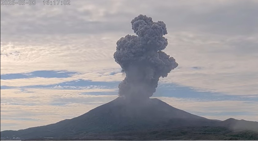
The Aira caldera in the northern half of Kagoshima Bay contains the post-caldera Sakurajima volcano, one of Japan’s most active. Eruption of the voluminous Ito pyroclastic flow accompanied formation of the 17 x 23 km caldera about 22,000 years ago. The smaller Wakamiko caldera was formed during the early Holocene in the NE corner of the caldera, along with several post-caldera cones. The construction of Sakurajima began about 13,000 years ago on the southern rim and built an island that was joined to the Osumi Peninsula during the major explosive and effusive eruption of 1914. Activity at the Kitadake summit cone ended about 4,850 years ago, after which eruptions took place at Minamidake. Frequent eruptions since the 8th century have deposited ash on the city of Kagoshima, located across Kagoshima Bay only 8 km from the summit. The largest recorded eruption took place during 1471-76.
Sources : Japan Meteorological Agency (JMA), GVP.
Indonesia , Dukono :
Latest information on Mount Dukono activity (May 14, 2026).
Volcanic activity at Mount Dukono, located on Halmahera Island in North Maluku Province, remains high, and the alert level is maintained at II. Situated in the districts of Galela and Tobelo, the volcano erupted on May 8, 2026, with a volcanic column reaching 10,000 meters above the summit. The eruption alert radius for Mount Dukono has been extended to 4 km from the epicenter and remains at Level II as of December 11, 2024, at 3:00 PM (Jakarta local time).
Mount Dukono’s volcanic activity from May 9 to May 14, 2026, was primarily eruptive, with an average of 48 eruptions recorded. The height of the eruptive columns varies from 600 to 4,300 meters. The last eruption occurred on May 14, 2026, at 7:12 AM WIT (local time). It was recorded on a seismogram with a maximum amplitude of 34 mm and a duration of 73.49 seconds. The observed eruptive column, which was thick and gray-black in color, reached a height of approximately 3,500 meters above the summit. The ash is dispersing mainly to the northwest, thus exposing residential areas and the city of Galela to the risk of volcanic fallout. This situation increases risks to public health and disrupts daily activities, including transportation and environmental hygiene.
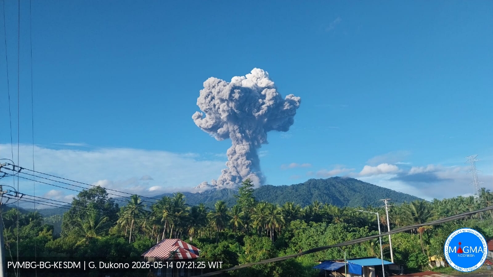
The Center for Volcanology and Geological Hazard Mitigation (PVMBG), the geological agency, advises the public, tourists, and climbers to avoid all activities within a 4-kilometer radius of the Malupang Warirang crater, the center of volcanic activity. In addition to the primary risk of ejected incandescent rock and ash, the public is also advised of the potential secondary risk of lahar flows, particularly during the rainy season. These flows could descend the Mamuya River to the north and the Mede and Tauni Rivers to the northeast, which originate at the summit of Mount Dukono.
Local authorities, including the Regional Disaster Management Agency (BPBD) of North Maluku Province and North Halmahera District, are urged to maintain active coordination with the Dukono Volcano observation post located in Mamuya Village.
Source et photo : PVMBG.