May 13 , 2026.
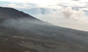
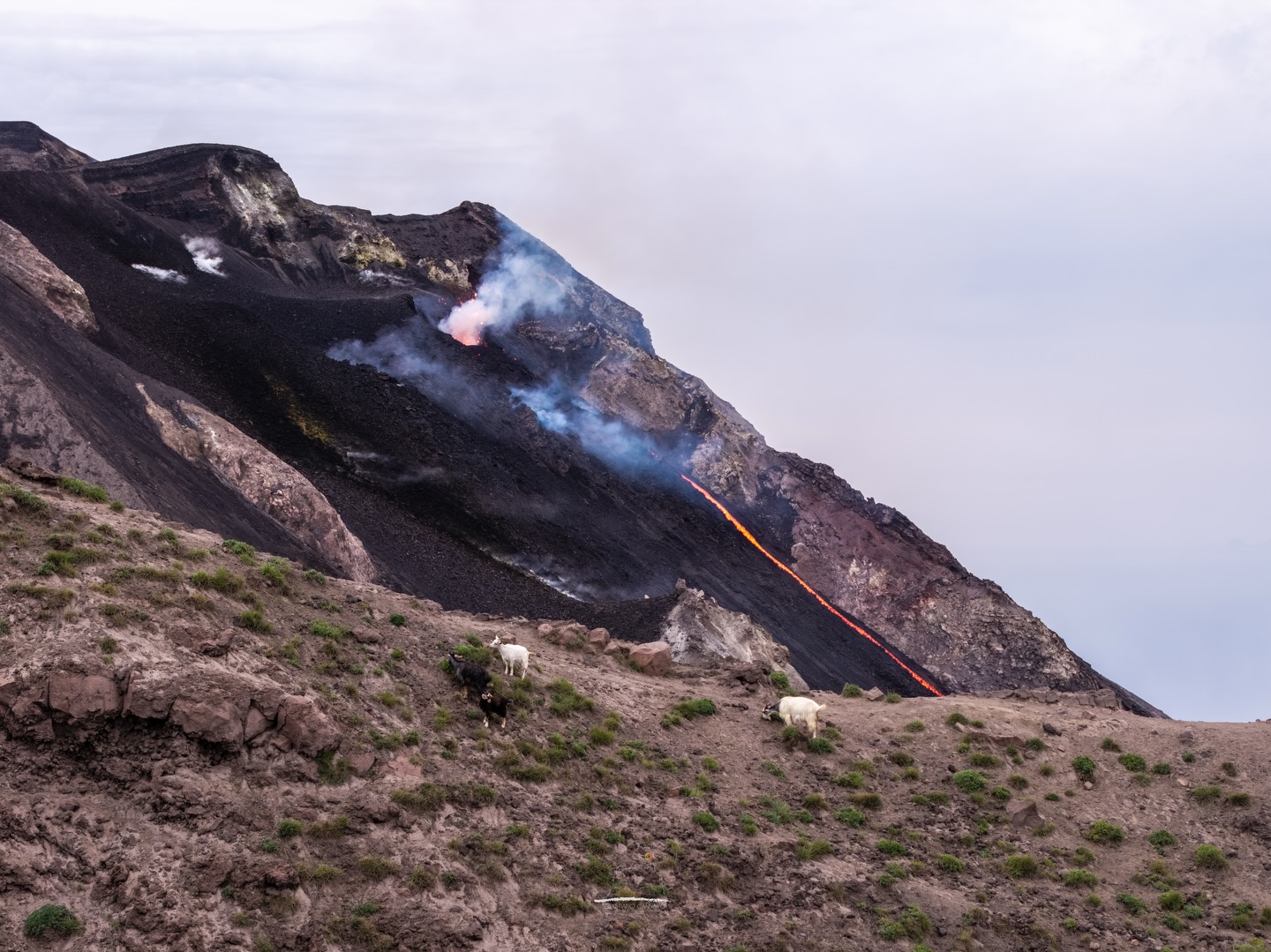
Iceland , Reykjanes Peninsula :
Ground uplift and magma accumulation continue beneath Svartsengi
A magmatic dike and an eruption on the Sundhnúks crater row remain the most likely scenario
Nearly 26 million cubic metres of magma have accumulated beneath Svartsengi
Seismic activity remains low in the area
The hazard assessment is unchanged and remains valid until 30 June
Deformation
Clear signs of deformation are still observed at Svartsengi, and ground uplift is continuing. The deformation continues to measure around 2 cm per month and the trend remains stable. Ground uplift and magma accumulation beneath Svartsengi continue at a similar rate to recent weeks. According to model calculations, nearly 26 million cubic metres of magma have accumulated beneath Svartsengi since the last eruption began on 16 July last year.
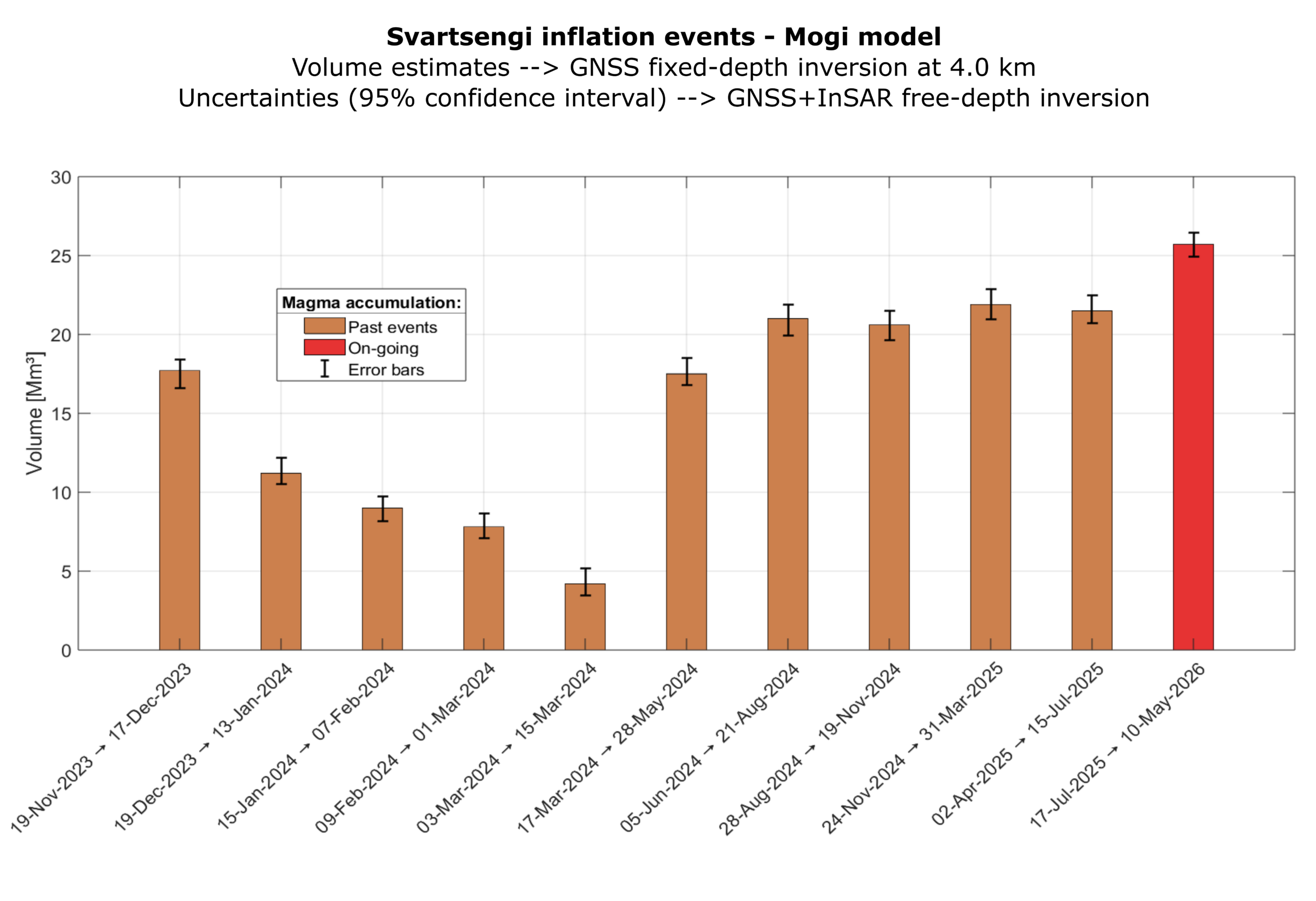
Comparison of the calculated volume of magma that has accumulated beneath Svartsengi between eruptions since November 2023. The red bar shows the current magma accumulation period, from 17 July 2025 to 10 May 2026.
Seismic activity
Minor activity is being detected near Grindavík and along the Sundhnúks crater row, as has been the case in recent months. The largest earthquake in recent weeks measured magnitude 1.2 on May 11, located between Þorbjörn and Grindavík.
Source : IMO.
Photos : Steinninn , IMO.
Italy , Stromboli :
WEEKLY BULLETIN, May 4, 2026 to May 10, 2026 (Publication date: May 12, 2026)
ACTIVITY SUMMARY
Based on monitoring data, the following points should be noted:
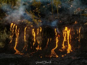
1) VOLCANOLOGICAL OBSERVATIONS: Ordinary and unusual Strombolian eruptive activity, with two episodes of effusive activity due to lava overflows in the North Crater area. Variable ejection activity in the North Crater area. Average total hourly frequency and average intensity in the North and Central-South Crater areas.
2) SEISMOLOGY: The monitored seismic parameters show no significant variation.
3) GROUND DEFORMATION: No significant variation is detected in the GNSS network time series.
4) GEOCHEMISTRY: SO₂ flux at an average level and increasing.
CO₂ flux from the soil in the Pizzo area (STR02) at average values.
C/S ratio in the plume: over the past week, it has remained at average values, except for May 8, when it was high to very high.
Helium isotope ratio (R/Ra) dissolved in the thermal aquifer: data from the last sampling, carried out on April 29, 2026, are very high (R/Ra = 4.50).
CO₂ flux from the soil in the San Bartolo area: at high values.
CO₂ flux from the soil in the Scari area: at average values.
5) SATELLITE OBSERVATIONS: Satellite-observed thermal activity in the summit area was generally moderate, with high values corresponding to the effusive event that began on May 4.
VOLCANOLOGICAL OBSERVATIONS
During the observation period, Stromboli’s eruptive activity was characterized by the analysis of images recorded by the INGV-OE monitoring cameras located at an altitude of 190 m and at Punta dei Corvi (SCT-SCV and SPCT, respectively). Explosive activity was primarily produced by five eruptive vents located in the North Crater area and by at least two vents located in the Central-South area. Between May 4 and 7, and between May 10 and 11, two lava flows occurred in the North Crater area.
Observations of explosive activity captured by the monitoring cameras
The overall average hourly frequency of explosive eruptive activity remained at a moderate level, with an increase to moderately high values on May 10. Regarding the intensity of explosive activity, it generally remained at moderate levels in both crater areas, but saw a temporary increase to high levels in the North crater area on May 10.
Specifically, in the North crater area, explosions were produced by five active vents, two located in sector N1 and three in sector N2, primarily producing coarse material (bombs and lapilli). Additionally, ejection activity was observed at vents in sector N2, reaching high intensity for brief periods on May 6 and 8. Two active vents were observed in the Central-South crater area, characterized by explosions of coarse material, sometimes mixed with fine material. In the early afternoon of May 9, ejection activity was observed at the vent adjacent to the North crater area.
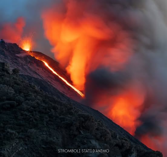
Effusive lava flow activity (times in GMT):
During the week of observation, the longest lava flow episode occurred.
The sequence of effusive activity began on the evening of May 4, following an intensification of lava ejections from the North Crater area. Specifically, starting at 5:37 a.m. on May 4, sector N2 of the North Crater area fed a small lava flow which, after a few hours, appeared to weaken. Around 6:30 p.m., a new lava flow formed from sector N2, rapidly extending into the central area of the Sciara del Fuoco, and then reaching the coast at 12:51 a.m. on May 5. From May 6 onward, the effusive activity was characterized by a slow decrease in flow rate. This decrease in flow resulted in a gradual retreat of the lava fronts to increasingly higher altitudes. On the morning of May 7, the flow appeared to be slowly being fed and cooling.
Around 4:00 PM on May 7, again from the N2 sector of the northern crater, a new impulse from the vent restarted the lava flow, producing flows whose most advanced fronts propagated for a few hundred meters, remaining confined to the upper-middle area of the Sciara del Fuoco. That same evening, the lava flow appeared to be slowly being fed, with the distal area cooling. The sector of the lava flow proximal to N2 remained poorly fed until the early morning of May 9, after which it cooled completely. On May 10 at 10:40 PM, a new, smaller lava flow emerged from the southern vent of sector N2 and spread for several hundred meters in the upper part of the Sciara del Fuoco. In the early hours of May 11, the flow appeared to be receiving little feed and cooling.
Source : INGV.
Photos : Stromboli stati d’animo / Sebastiano Cannavo.
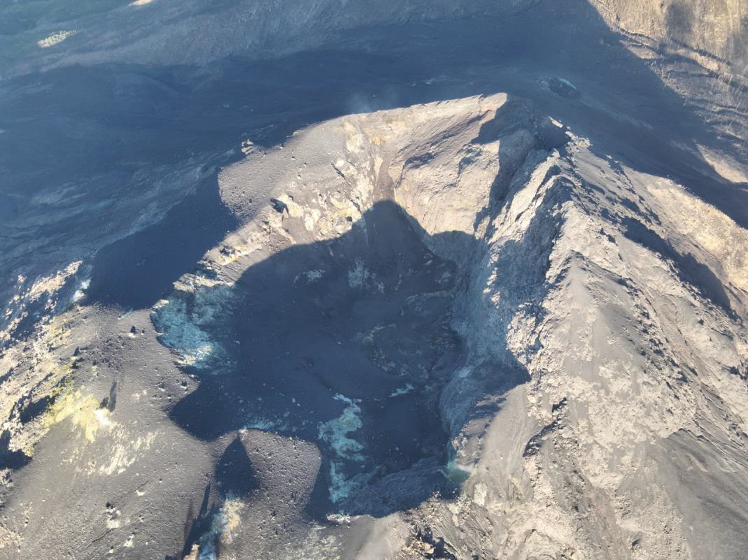
Indonesia , Lewotobi Laki-laki :
Increased activity level of Mount Lewotobi Laki-laki, in the Eastern Lesser Sunda Islands (ESTI), from Level II (WASPADA) to Level III (SIAGA) on May 12, 2026, at 1:00 PM WITA.
From May 1 to 11, 2026, activity at Mount Lewotobi Laki-laki increased significantly, particularly in deep seismic parameters. This activity was dominated by deep volcanic earthquakes (DVAs), with a peak of 21 to 32 events per day at the beginning of the period, and especially from May 1 to 4, 2026. This increase in DVAs indicates a significant influx of magma or magmatic fluids from the depths of the volcanic system. After peaking in early May, the number of SVPs (Seismic Volcanic Propulsion) gradually decreased, stabilizing at around 8 to 12 events per day on May 10, while remaining above previous normal levels, indicating that magma replenishment was continuing.
In addition to deep volcanic earthquakes, non-harmonic tremor activity remained high and relatively persistent during this period, with 17 to 27 events per day. On May 9, this number even reached 27 events. The predominance of non-harmonic tremors indicates that the fluid system in the surface layer remains active and in continuous motion. Although low-frequency (LF) seismic activity remained relatively weak, this suggests that internal pressure is beginning to build up in the surface layer.
Surface activity was not yet visible, despite the occurrence of avalanches and eruptions on several observation days, notably May 2 and 3, as well as May 6. This activity indicates that internal pressure is beginning to affect the crater surface. Furthermore, fumaroles from the solfatara were not visible in the crater center, but only in the northwest. Local and distant tectonic activity was recorded as fluctuating, but does not appear to have been a determining factor in the increase in primary volcanic activity during this period.
Deformation data from the Wolorona Inclinometer (WLR2) reveal a crucial trend for interpreting current activity. The y-axis shows a steady and increasingly pronounced upward progression until early May 2026, indicating swelling due to pressure buildup within the volcano. Simultaneously, the x-axis shows a downward progression, reflecting changes in lateral deformation. The combination of the swelling measured by WLR2 and strong deep volcanic activity (VA) indicates that the Lewotobi magmatic system is undergoing active pressure recharging.
Compared to historical trends observed in 2024, current conditions resemble the initial phase of heightened activity preceding an eruption, characterized primarily by increased deep volcanic activity (VA), followed by inflationary deformation and intense harmonic/non-harmonic tremor. However, surface parameters such as the LF (Laser Fathoms) and shallow volcanic activity (VB) have not yet reached the intensity levels observed during the major explosive phase of 2025. Therefore, the current activity of Mount Lewotobi Laki-laki is interpreted as a phase of increased magmatic pressure, which could evolve into a small to medium-sized eruption if the pressure continues to build and is more concentrated in the shallower parts of the volcanic system.
Following visual and instrumental analysis, the activity level of Mount Lewotobi Laki-laki has been raised from Level II (waspada) to Level III (Siaga). The following recommendations are issued: the public and tourists are advised to refrain from any activity within a 5 km radius of the eruptive center, remain calm, and follow the instructions of local authorities. The public is also asked to disregard information from unknown sources.
Source et photo : PVMBG.
Colombia , Puracé – Los Coconucos volcanic chain :
Popayán, May 12, 2026, 3:00 PM
Following monitoring of activity at the Puracé volcano and the Los Coconucos volcanic chain, the Colombian Geological Survey (SGC), an agency under the Ministry of Mines and Energy, reports the following:
During the week of May 5-11, 2026, variations in seismic activity were observed, primarily related to an increase in the energy of continuous tremor (TR), located beneath the craters of the Puracé and Piocollo volcanoes, at depths of less than 3 km. This activity was associated with circulation processes, the release of volcanic gases, and ash emissions into the atmosphere from the Puracé volcano crater, reaching a maximum altitude of 2 km above the volcano’s summit and dispersing toward the northwest of the volcanic edifice, following the prevailing wind direction. Very fine ashfall and strong sulfur odors were reported in the Puracé town hall, the rural communes of Alto de Anambío, 20 de Julio, Cristales, and Loma Linda (in the commune of Puracé), and the city of Popayán.
Fracture seismic activity remained stable compared to the previous week, both in frequency and energy, and was mainly located between the Puracé and Piocollo volcanoes, at depths of 1 to 3 km, with a magnitude of less than 1. Images captured by satellite sensors and visible and infrared webcams continued to show thermal anomalies inside the Puracé volcano crater and in the fumarole field on its outer rim, as well as degassing activity in the Puracé and Curiquinga volcano craters. Similarly, thanks to field instruments and satellite data, an increase in sulfur dioxide (SO2) emissions was observed compared to previous weeks, although it did not exceed the levels recorded in December 2025. In addition, the slow deformation process persists between the Puracé, Piocollo and Curiquinga volcanoes, detected after the eruptive episode of the Curiquinga volcano on January 20, 2025.
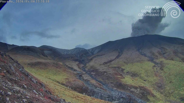
Recording from the Piocollo camera, located 1.5 km southeast of the Puracé volcano, showing an ash emission on May 8, 2026, at 5:20 PM (local time).
In conclusion, the observed variations at the Puracé volcano – part of the Los Coconucos volcanic chain – indicate that the system continues to evolve and that further ash emissions and fallout are possible, dispersed according to the prevailing wind direction. The public is advised not to travel to the higher elevations of the volcanic chain and to remain attentive to official bulletins from the Geological Survey of Colombia (SGC).
The alert level for volcanic activity remains yellow: active volcano with changes in the baseline behavior of monitored parameters and other manifestations.
Source et photo : SGC.
Guatemala , Santiaguito :
Atmospheric conditions: Clear skies
Wind: North
Rainfall: 2.8mm
Activity:
White outgassing is observed above the Caliente dome, with fumaroles rising up to 600 meters and dispersing to the southwest. One to three low- to medium-intensity explosions occur per hour, projecting columns of gas and ash up to 800 meters above the dome in the same direction. Incandescence was recorded in the crater during the night and early morning, accompanied by collapses and the fall of incandescent blocks on its flanks.
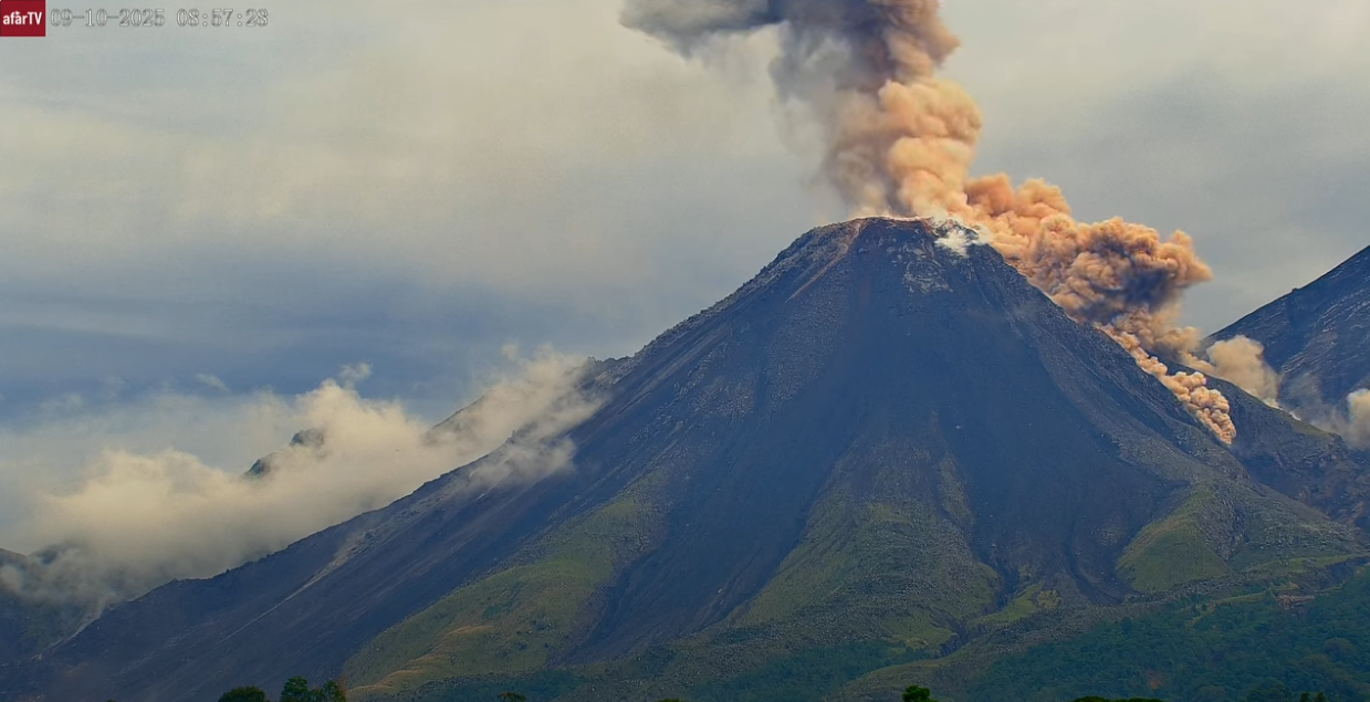
Given the high level of activity and the risk of major collapses, the formation of large-scale pyroclastic flows in all directions cannot be ruled out; therefore, it is recommended to follow the instructions in Special Bulletin BESAN-002-2026. Furthermore, rainfall may dislodge accumulated material from ravines and riverbeds, causing lahars in the afternoon and evening. It is recommended to avoid ravines and riverbeds and to strictly follow the instructions in Special Bulletin BESAN-012-2026.
Source : Insivumeh.
Photo : Afar TV.