February 16 , 2026.
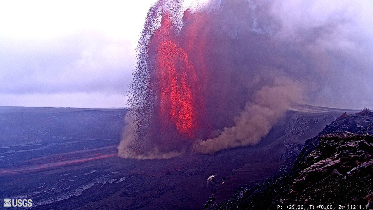
Hawaii , Kilauea :
HVO/USGS Volcanic Activity Notice
Current Volcano Alert Level: WATCH
Current Aviation Color Code: ORANGE
Issued: Sunday, February 15, 2026, 3:15 PM HST
Source: Hawaiian Volcano Observatory
Notice Number: 2026/H83
Location: N 19 deg 25 min W 155 deg 17 min
Elevation: 4091 ft (1247 m)
Area: Hawaii
Volcanic Activity Summary:
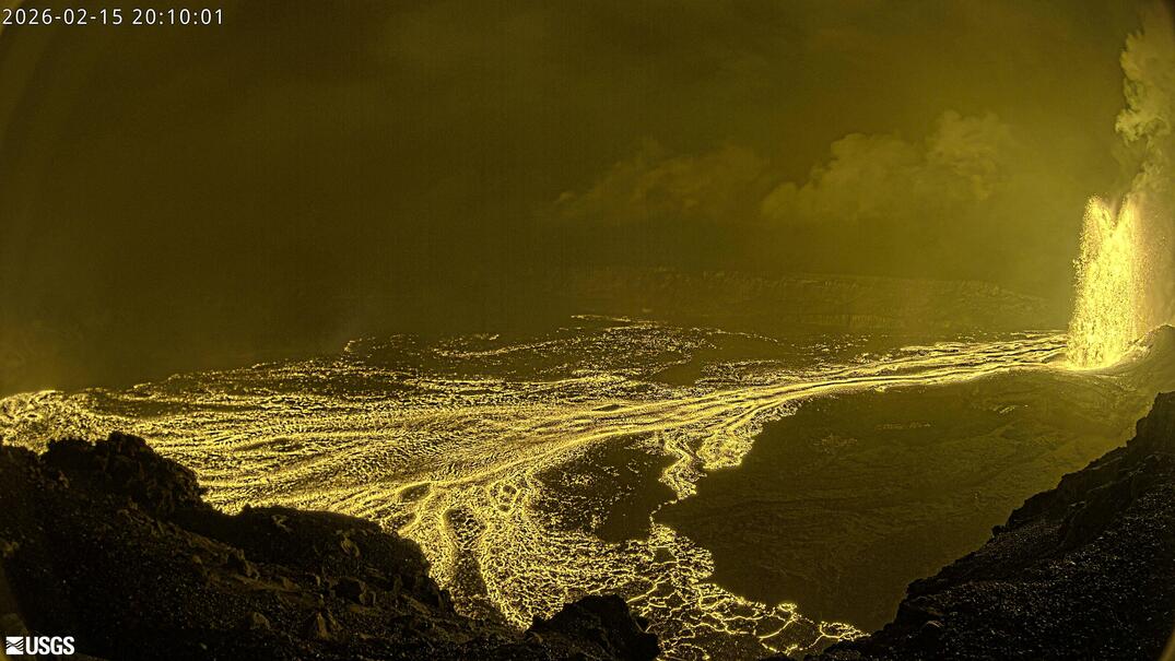
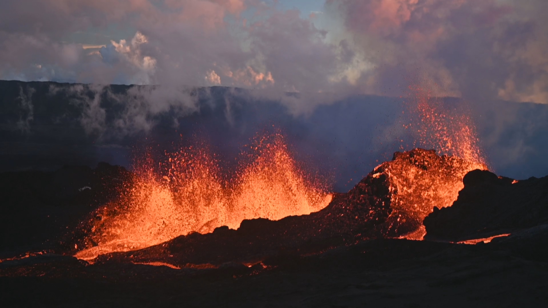
Episode 42 of lava fountaining in Halemaʻumaʻu began at the summit of Kīlauea began at 1:50 p.m. HST on February 15, 2026, and continues as of this notice.
Two fountains are present both approaching or exceeding 1000 feet (300 meters) in height. The fountains are producing heat and ash that is driving the plume rising from the eruption site.
The National Weather Service reports that the plume from this eruption is reaching 35,000 feet above sea level. Ground-level sensors near the eruptive vents indicate that winds are blowing from the northeast direction, which suggests that volcanic gas emissions and volcanic material may be distributed to the southwest direction from Halemaʻumaʻu near the ground. However at this time ground crews in the area report no ashfall. Above 18,000 feet above sea level, winds are from the west and may distribute volcanic material to the east.
All eruptive activity is confined to Halemaʻumaʻu crater within Hawaiʻi Volcanoes National Park
Recent Observations:
[Volcanic cloud height] NWS reports a plume top height of 35,000 feet above sea level. Plume in past episodes has reached up to or above 20,000 feet (6000 meters) above ground level, driven by incandescent lava fountains up to or over 1500 feet (457 meters) high.
[Other volcanic cloud information] Most volcanic ash and pumice (tephra) falls within about 1 mile (1-2 km) of the eruptive vents during eruptive episodes. Lower concentrations of finer volcanic particles, such as ash and Pele’s Hair, can be transported greater distances downwind of the vent (20 miles or 30 km). Sulfur dioxide emission rate is typically 50,000-100,000 tonnes/day during an eruptive episode.
Remarks:
Volcanic Gas: water vapor (H2O), carbon dioxide (CO2), and sulfur dioxide (SO2) are continuously released during an eruption. SO2 reacts in the atmosphere to create the visible haze known as vog (volcanic air pollution) downwind, which may cause respiratory and other problems.
Source et photos : HVO.
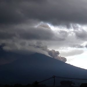
La Réunion Island , Piton de la Fournaise :
The lava flow front is now stable at the base of the Grandes Pentes. At 4:30 p.m., the lava was 2.6 km from National Route 2, according to the Piton de la Fournaise Volcanological Observatory (OVPF). « If the lava flow rates remain constant, an advance of the flow towards the road is unlikely, » the prefecture stated in a press release issued at midday on Sunday. Only one fissure remains active. Access to the caldera is prohibited to the public.
In its 8 p.m. bulletin on Sunday, February 15, 2026, the OVPF noted that the eruption at Piton de la Fournaise was continuing. However, it added: « Due to the decrease in flow rates, the lava flow front located in the Grandes Pentes is no longer active, and the active flows, visible at night, are located upstream of the Grandes Pentes. » Volcanologists indicate that the eruption continues but: « the flow is frozen in the lower part of the Grandes Pentes at around 660 meters altitude (2.6 km from the road, distance reassessed).
« Due to persistent seismic activity beneath the summit, indicating that the magma system remains under pressure, new fissures could open in the coming hours, particularly further downstream, » warned the Piton de la Fournaise Volcanological Observatory (OVPF) on Sunday morning, adding that it « remains on continuous alert to monitor the situation. »
As a reminder, the Piton de la Fournaise volcano erupted on Friday morning, February 13, 2026.
Lava erupted after a short but significant seismic crisis that began at 9:25 a.m. Thirty-five minutes later, at 10:00 a.m., lava reached the surface, according to the OVPF. Four fissures were open at that time, and two remained active in the afternoon.
The prefect has urgently activated alert 2.1 of the ORSEC emergency plan, « Volcano: Eruption within the Enclos. » Access to the Enclos is prohibited to the public.
Since Friday, February 13, 2025, state services have been regulating travel and parking in the area of the Route des Laves.
Sources : Imaz press , OVPF.
Photo : Réunion la 1ère.
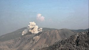
Indonesia , Semeru :
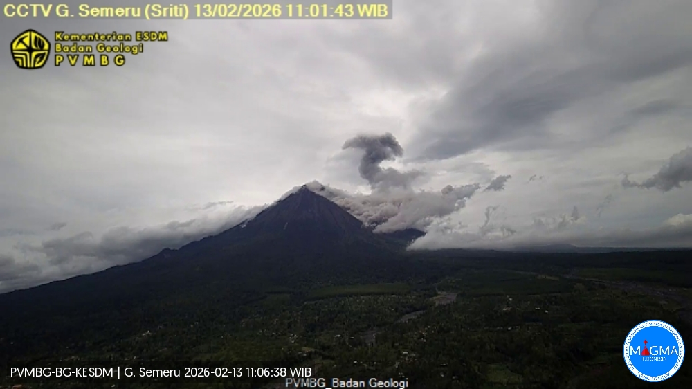
Repeated pyroclastic avalanches on Mount Semeru, East Java, from February 1 to 14, 2026.
Mount Semeru, located in the Lumajang and Malang districts of East Java province, remained at Volcanic Level III (Siaga) in mid-February 2026. Volcanic activity at this volcano remains high, characterized by repeated pyroclastic avalanches, primarily to the southeast, with a plume rising up to 4,000 meters from the summit in the direction of Besuk Kobokan.
Based on visual and instrumental monitoring, two pyroclastic avalanches were observed on February 14, 2026, with a plume rising up to 6,000 meters from the summit to the southeast. Furthermore, between February 1st and 13th, 2026, pyroclastic avalanches were also observed on several occasions, with plumes rising to between 2,500 and 4,000 meters, accompanied by ashfall. Seismic activity is dominated by eruption earthquakes, collapse earthquakes, and harmonic tremors. The recorded earthquakes indicate a continuous supply of subsurface material, as well as the release of surface material by eruptions.
Seismic velocity variation parameters (dv/v) have fluctuated but have shown a downward trend since mid-October 2025, indicating that the volcanic system is in a relaxation phase and is not experiencing high pressure (pressurization), while remaining highly vulnerable to pressure increases. Inclinometer monitoring data from the Argosuko station, on the radial component, indicate a rapid acceleration/change, interpreted as a local mechanical response in the surface system (e.g., an adjustment of stresses and loads on the surface body), rather than a deformation response controlled by strong magmatic inflation.
Following the analysis and evaluation of the results, the activity level of Mount Semeru remains at level III (Siaga). Local residents, visitors, and climbers are strongly advised to avoid activities within a 5-kilometer radius of the Jonggring Seloko crater and to refrain from entering the southeastern sector, up to 13 kilometers from the summit, or even 17 kilometers along the Besuk Kobokan lava flow. The local population is aware of the risks of hot clouds, lava avalanches, and lahars along the flow originating at the summit of Mount Semeru, particularly along the Besuk Kobokan, Besuk Bang, Besuk Kembar, and Besuk Sat rivers, as well as the risk of lahars in the smaller streams that feed into the Besuk Kobokan.
Source et photo : PVMBG.
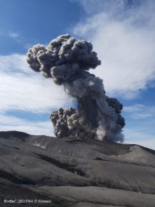
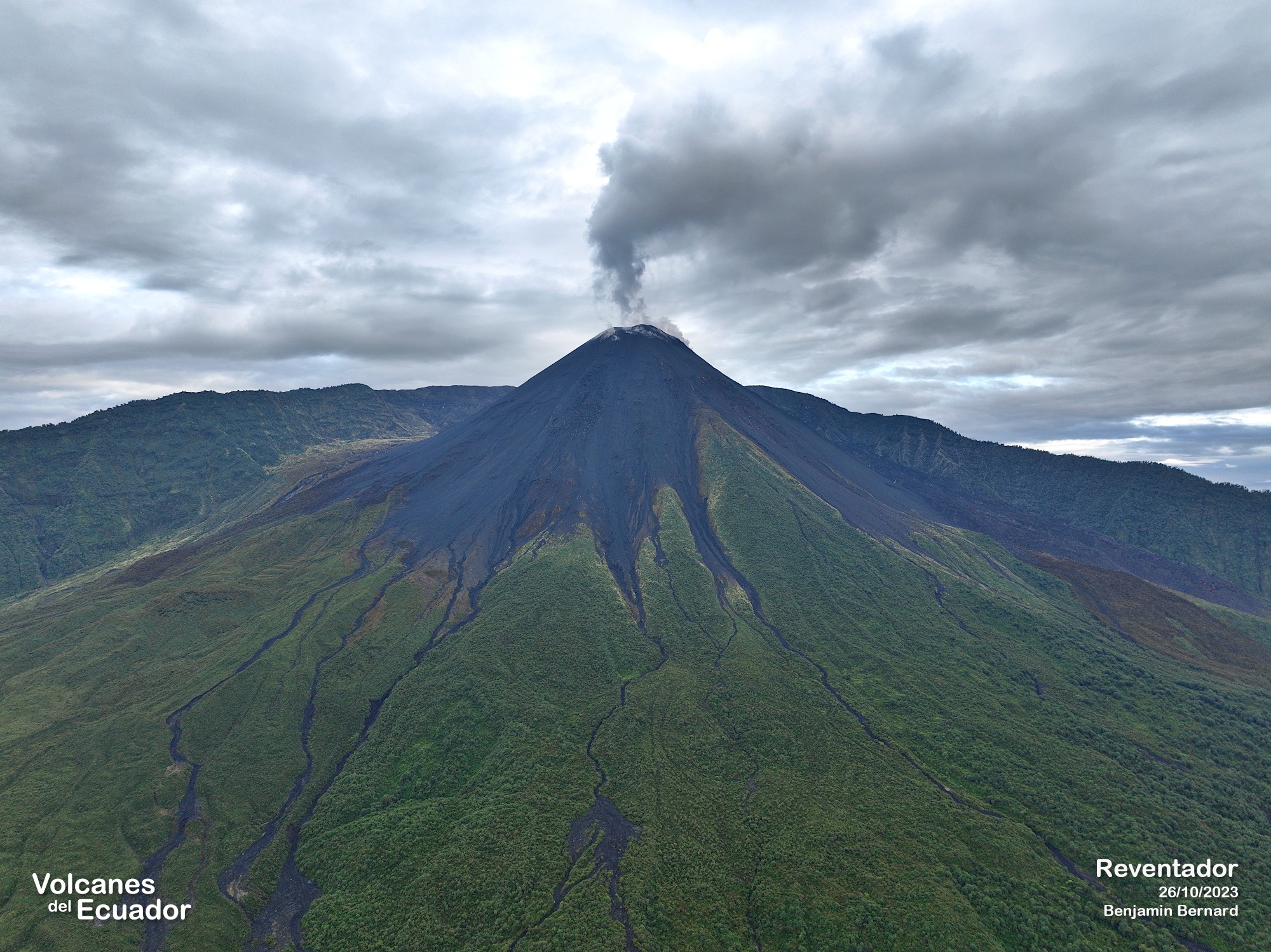
Ecuador , El Reventador :
REVENTADOR VOLCANO DAILY STATE REPORT, Sunday, February 15, 2026.
Information Geophysical Institute – EPN.
Surface Activity Level: High, Surface Trend: No Change
Internal Activity Level: Moderate, Internal Trend: No Change
From February 14, 2026, 11:00 AM to February 15, 2026, 11:00 AM:
Seismicity:
Due to data transmission issues, it is not possible to count events from the last 24 hours.
Rainfall/Lahars:
No precipitation has been recorded in the volcano’s vicinity. In the event of heavy rainfall, accumulated material could be remobilized, generating mudflows and debris flows that would cascade down the volcano’s flanks and flow into nearby rivers.
Emissions/Ash:
Due to transmission problems and poor weather conditions, it was not possible to observe any gas or ash emissions via the surveillance camera system or satellite systems. Similarly, the VAAC agency in Washington has not issued any emissions reports for this volcano.
Gas:
The MOUNTS satellite system detected 5.1 tons of sulfur dioxide (SO₂), measured at 1:24 p.m. local time on February 14, 2026.
Note:
From yesterday afternoon until the closing of this report, the volcano remained completely shrouded in mist.
Alert Level – SGR: Orange
Source : IGEPN.
Photo : Benjamin Bernard
Costa Rica , Poas :
OVSICORI-UNA Volcano Weekly Monitoring Bulletin, February 13, 2026
Latitude: 10.20°N
Longitude: 84.23°W
Altitude: 2687 m
Current Activity Level: Alert
This week, the tremor amplitude has gradually increased, exhibiting a monochromatic character with a dominant frequency of approximately 2.8 Hz. The number of long-period events has decreased compared to last week. High-frequency events continue to be recorded, although their number and amplitude have decreased this week. The geodetic network records an uplift of the crater relative to the tourist building, as well as a slight extension to the south of the volcano (VPCL and VPJA) relative to the same building.
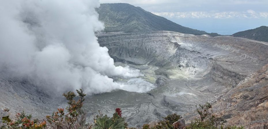
The MultiGAS station recorded SO₂/CO₂ values lower than the previous week, while the H₂S/SO₂ ratio remained similar. The SO₂ concentration at the observation point reached a maximum of 1.1 ppm this week. DOAS stations detected a sulfur dioxide (SO₂) flux of 83 ± 42 t/d, lower than the previous week’s 140 ± 136 t/d. SO₂ was detected in the atmosphere by satellite on February 7, with a low flux of 4.3 tonnes. The lake level, where observable, remained stable this week.
Source et photo : Ovsicori .