February 2 , 2026.
Kamchatka , Sheveluch :
KVERT VOLCANIC ACTIVITY NOTICE (VAN)
Issued: February 2 ,2026
Volcano: Sheveluch (CAVW #300270)
Current aviation colour code: ORANGE
Previous aviation colour code: red
Source: KVERT
Notice Number: 2026-13
Volcano Location: N 56 deg 38 min E 161 deg 19 min
Area: Kamchatka, Russia
Summit Elevation: 3283 m (10768.24 ft), the dome elevation ~2500 m (8200 ft)
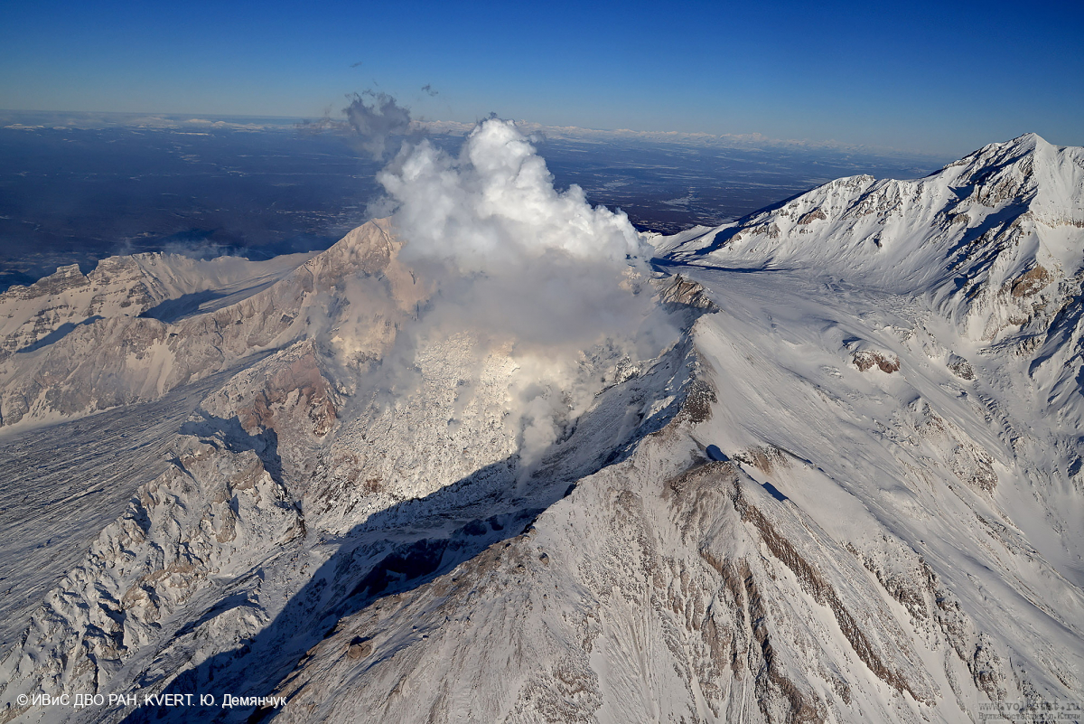
Volcanic Activity Summary:
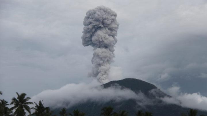
The explosive-extrusive eruption of the volcano continues. New explosions sent ash up to 7.5 km a.s.l., ash cloud move 36 km to the northeast. The other cloud 135×60 km move 228 km to the northwest.
Ongoing activity could affect international and low-flying aircraft.
Volcanic cloud height:
7500 m (24600 ft) AMSL Time and method of ash plume/cloud height determination: 20260202/0450Z – Himawari-9 14m15
Other volcanic cloud information:
Distance of ash plume/cloud of the volcano: 36 km (22 mi)
Direction of drift of ash plume/cloud of the volcano: NNE / azimuth 19 deg
Time and method of ash plume/cloud determination: 20260202/0450Z – Himawari-9 14m15
Start time of explosion and how determined: 20260202/0435Z – Satellite data.
Source : Kvert .
Photo : Yu. Demyanchuk. IVS FEB RAS, KVERT ( archive).
Indonesia , Ibu :
Mount Ibu experienced an eruption on Monday, February 2, 2026 at 00:45 UTC (09:45 local time). No visual observations of the eruption were made. The eruption was recorded by a seismograph with a maximum amplitude of 28 mm and a duration of 39 seconds.
Seismic Observations:
107 eruption earthquakes with amplitudes ranging from 10 to 28 mm and durations from 38 to 69 seconds.
11 harmonic tremors with amplitudes ranging from 3 to 28 mm and durations from 36 to 108 seconds.
82 low-frequency earthquakes with amplitudes ranging from 2 to 10 mm and durations from 17 to 29 seconds.
116 shallow volcanic earthquakes with amplitudes ranging from 2 to 6 mm and durations from 7 to 21 seconds.
A deep volcanic earthquake with an amplitude of 25 mm and a duration of 21.9 seconds.
Two local tectonic earthquakes with amplitudes of 6 to 9 mm and durations of 21 to 32 seconds.
Seven distant tectonic earthquakes with amplitudes of 4 to 28 mm and durations of 38 to 80 seconds.
VOLCANO OBSERVATORY NOTICE FOR AVIATION – VONA
Issued : February 2 , 2026
Volcano : Ibu (268030)
Current Aviation Colour Code : ORANGE
Previous Aviation Colour Code : yellow
Source : Ibu Volcano Observatory
Notice Number : 2026IBU045
Volcano Location : N 01 deg 29 min 17 sec E 127 deg 37 min 48 sec
Area : North Maluku, Indonesia
Summit Elevation : 4240 FT (1325 M)
Volcanic Activity Summary :
Eruption at 00h45 UTC (09h45 local).
Volcanic Cloud Height :
Ash-cloud is not observed.
Other Volcanic Cloud Information :
Ash-cloud is not observed.
Remarks :
Eruption recorded on seismogram with maximum amplitude 28 mm and maximum duration 39 second.
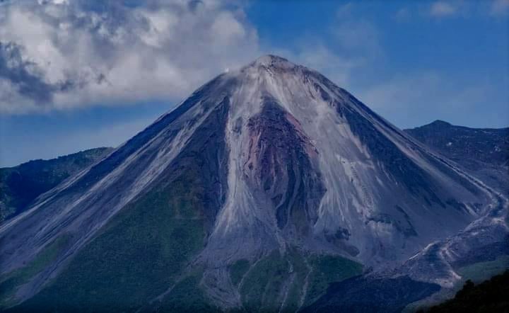
Source : Magma Indonésie.
Photo : Tempo ( archive).
Ecuador , El Reventador :
REVENTADOR VOLCANO DAILY STATE REPORT, Sunday, February 1, 2026.
Information Geophysical Institute – EPN.
Surface Activity Level: High, Surface Trend: No Change
Internal Activity Level: Moderate, Internal Trend: No Change
From January 31, 2026, 11:00 AM to February 1, 2026, 11:00 AM:
Seismicity:
The table below shows the number of seismic events recorded at the reference station:
Explosion (EXP) 95
Long Period (LP) 8
Emission Tremor (TREMI) 5
Harmonic Tremor (TRARM) 4
Rainfall/Lahars:
No rainfall has been recorded in the volcano area. **Heavy rain could remobilize accumulated material, generating mudflows and debris flows that would cascade down the volcano’s flanks and flow into nearby rivers.**
Emissions/Ash Column:
Due to transmission problems and weather conditions, it was not possible to observe gas or ash emissions using the surveillance camera system and satellite systems. However, the Washington VAAC agency issued a report indicating gas and ash emissions reaching an altitude of 700 meters above the crater, drifting westward.
Observation:
From yesterday afternoon until the writing of this report, the GOES-19 satellite system observed that the volcano remained completely obscured by clouds.
Alert Level – SGR: Orange
Source : IGEPN.
Photo : Henry Vasconez.
Hawaii , Kilauea :
HAWAIIAN VOLCANO OBSERVATORY DAILY UPDATE , U.S. Geological Survey
Sunday, February 1, 2026, 9:28 AM HST (Sunday, February 1, 2026, 19:28 UTC)
19°25’16 » N 155°17’13 » W,
Summit Elevation 4091 ft (1247 m)
Current Volcano Alert Level: WATCH
Current Aviation Color Code: ORANGE
Activity Summary:
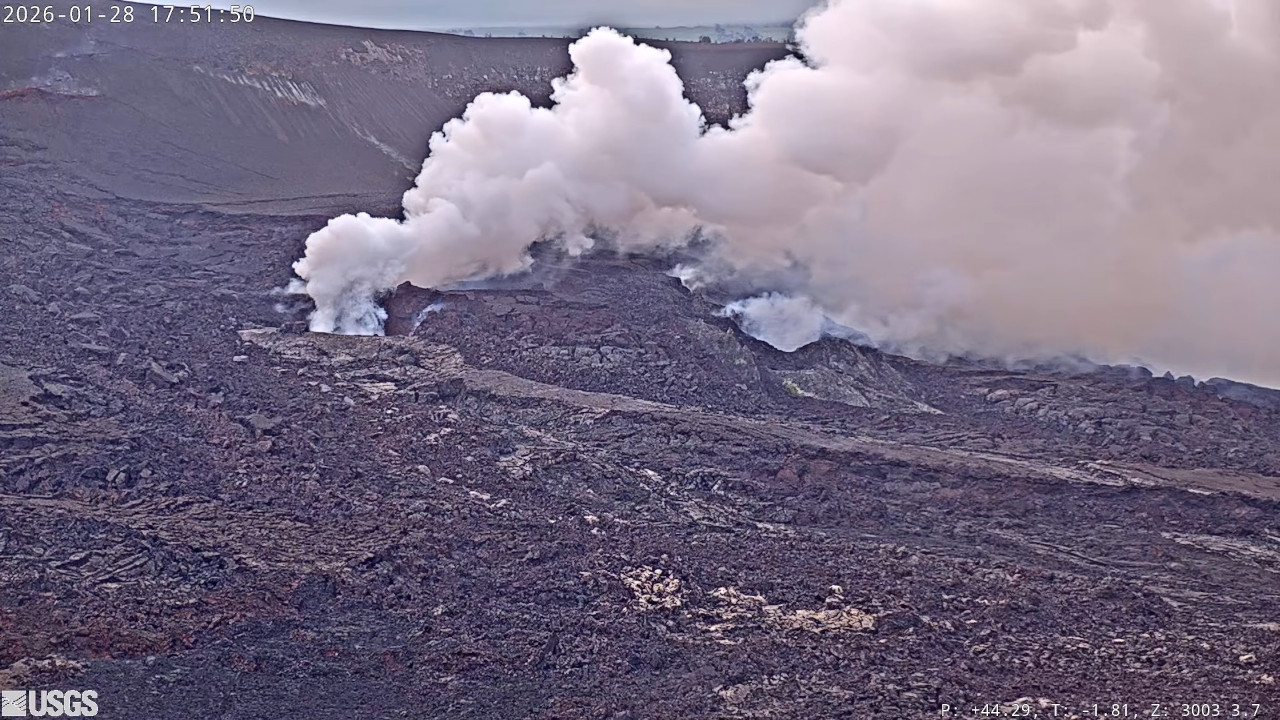
The Halemaʻumaʻu eruption of Kīlauea is paused. Intermittent glow was visible overnight from the south vent. Summit inflation and seismic tremor continued over the past 24 hours. The forecast for the onset of episode 42 lava fountaining is between February 11 and 16 based on current rates of summit inflation. The forecast window will be refined as more data become available. No significant activity has been noted along Kīlauea’s East Rift Zone or Southwest Rift Zone.
Summit Observations:
Intermittent moderate to bright glow from the south vent was visible on webcams overnight, similar but brighter at times than recent nights. Very little glow was visible from the north vent and appeared to be associated with flames like those seen at 12:53 a.m. HST this morning similar to yesterday.
Seismic tremor continued over the past 24 hours. Recurring pulses of increased tremor beneath the summit occurred several times per hour. These pulses correlate with periods of increased brightness at the south vent, suggesting that gas pistoning is probably occuring within that conduit. Three earthquakes less than magnitude 1 were located beneath Kīlaueaʻs summit over the past 24 hours.
The Uēkahuna tiltmeter (UWD) has recorded 16.8 microradians of inflationary tilt since the end of episode 41, including 1.6 microradians of inflationary tilt in the past 24 hours.
The sulfur dioxide (SO2) emission rate from the summit was last measured on January 14 at 1,550 tonnes per day, which is within the typical range of 1,000 to 5,000 tonnes of SO2 per day observed during previous eruptive pauses. This is considerably lower than rates observed during lava fountaining episodes.
Rift Zone Observations:
Rates of seismicity and ground deformation remain very low in the East Rift Zone and Southwest Rift Zone. SO2 emissions from the East Rift Zone remain below the detection limit.
Source et photo : USGS.
Guatemala , Santiaguito :
Atmospheric conditions: Clear skies
Wind: North
Rainfall: 1.6 mm
Activity
Constant outgassing is observed above the Caliente dome, reaching a height of 400 meters and dispersing to the south and southwest. Low- to medium-intensity explosions have been recorded, with a column of gas and ash rising up to 800 meters above the dome and dispersing to the south and southwest. During the night and early morning, incandescence can be observed on the dome itself and its western and southwestern flanks, resulting from recurring avalanches cascading down these slopes.

The possibility of pyroclastic density currents cannot be ruled out; therefore, it is essential to follow the recommendations of Special Bulletin BESAN-063-2025.
Given the presence of rain within the volcanic perimeter, low- to medium-intensity lahars may occur along the riverbeds on the southern flank (Nimá i Tambor, Cabello de Ángel, among others); therefore, follow the recommendations of Special Bulletin BESAN-012-2025.
Source : Insivumeh
Photo : Annie Winson , earthobservatory.sg ( archive).