January 30 , 2026.
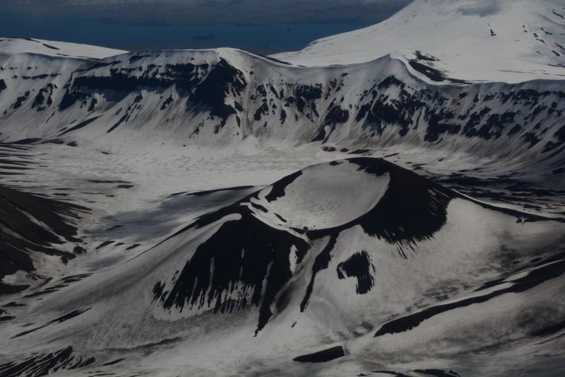
Japan , Yakedake :
The Japan Meteorological Agency (JMA) raised the Alert Level for Yakedake to 2 (on a scale of 1-5) at 05h50 on 25 January because of increased deformation and seismicity. Inflation near the summit was detected in Global Navigation Satellite Systems (GNSS) data beginning at around 01h00 and the number of small volcanic earthquakes with epicenters near the summit began increasing around 02h00 that same morning. The seismic network recorded a preliminary total of 75 volcanic earthquakes on 25 January, 37 on 26 January, and 22 on 27 January. No volcanic tremors were recorded. JMA warned the public to be cautious within 1 km of the crater.
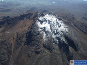
Yakedake rises above the popular resort of Kamikochi in the Northern Japan Alps. The small dominantly andesitic stratovolcano, one of several Japanese volcanoes named Yakedake or Yakeyama (« Burning Peak » or « Burning Mountain »), was constructed astride a N-S-trending ridge between the older volcanoes of Warudaniyama and Shirataniyama. Akandanayama, about 4 km SSW, is a stratovolcano with lava domes that was active into the Holocene. A 300-m-wide crater is located at the summit, and explosion craters are found on the SE and N flanks. Frequent small-to-moderate phreatic eruptions have occurred during the 20th century. On 11 February 1995 a hydrothermal explosion in a geothermal area killed two people at a highway construction site.
Sources: Japan Meteorological Agency (JMA), GVP.
Photo : Lee Siebert, 1977 (Smithsonian Institution).
Alaska , Omok :
ALASKA VOLCANO OBSERVATORY INFORMATION STATEMENT , U.S. Geological Survey
Thursday, January 29, 2026, 5:55 PM AKST (Friday, January 30, 2026, 02:55 UTC)
53°23’49 » N 168°9’58 » W,
Summit Elevation 3520 ft (1073 m)
Current Volcano Alert Level: NORMAL
Current Aviation Color Code: GREEN
Strong northerly winds in the vicinity of Okmok and Vsevidof volcanoes on Umnak Island have picked up loose volcanic ash and dust on the surface and are carrying it to the south. The clouds of resuspended volcanic ash are visible in satellite data. The National Weather Service has issued a SIGMET for this low-level event and suggests that the maximum cloud height is 3,000 ft (0.9 km) above sea level.
This phenomenon is not the result of recent volcanic activity and occurs during times of high winds and dry snow-free conditions at Okmok, Vsevidof, and other volcanic areas of Alaska. No eruption is in progress. Okmok Volcano remains at Aviation Color Code GREEN and Alert Level NORMAL. Resuspended volcanic ash should be considered hazardous and could be damaging to aircraft and health.
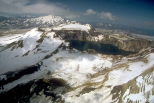
Okmok volcano is a 10-kilometer (6-mile) -wide caldera that occupies most of the eastern end of Umnak Island, located 120 kilometers (75 miles) southwest of Unalaska/Dutch Harbor in the eastern Aleutian Islands. Okmok has had several eruptions in historical time typically consisting of lava flows crossing the caldera floor, such as in 1945, 1958, and 1997. However, in 1817, Okmok produced an explosive eruption that resulted in ash fall in the Dutch Harbor area. The volcano last erupted in July–August 2008, producing continuous ash emissions that fluctuated between about 1,500 and 9,000 meters (5,000 and 30,000 feet) above sea level for the 5-week duration of the eruption, with an initial plume height of 15,000 meters (50,000 feet) during the first 12 hours. This eruption resulted in the construction of a new cone (Ahmanilix) within the caldera.
The nearest settlement is Nikolski, about 70 kilometers (45 miles) west of the volcano. A ranch caretaker family lives at Fort Glenn on the flank of the volcano about 10 kilometers (6 miles) east of the caldera rim during the summer months.
Source : AVO.
Photo : Mees, Burke.
Philippines , Mayon :
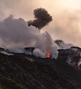
The Philippine Institute of Volcanology and Seismology (PHIVOLCS) reported that the eruption at Mayon continued during 22-28 January, characterized by effusion and collapses at the summit dome, pyroclastic density currents (PDCs), rockfalls, ash plumes, avalanches of incandescent material, and lava flows. Lava flows in the Mi-Isi (S), Bonga (SE), and Basud (E) drainages continued to advance and were 1.3-3.2 km long by 24 January. Episodic and minor Strombolian activity was visible during 21-22 and 25-27 January. Moderate emissions rose as high as 1 km above the summit and drifted in various directions on most days; weather clouds obscured views on 21 and 26 January. The seismic network recorded 155-317 daily rockfall events and 29-106 daily PDCs.
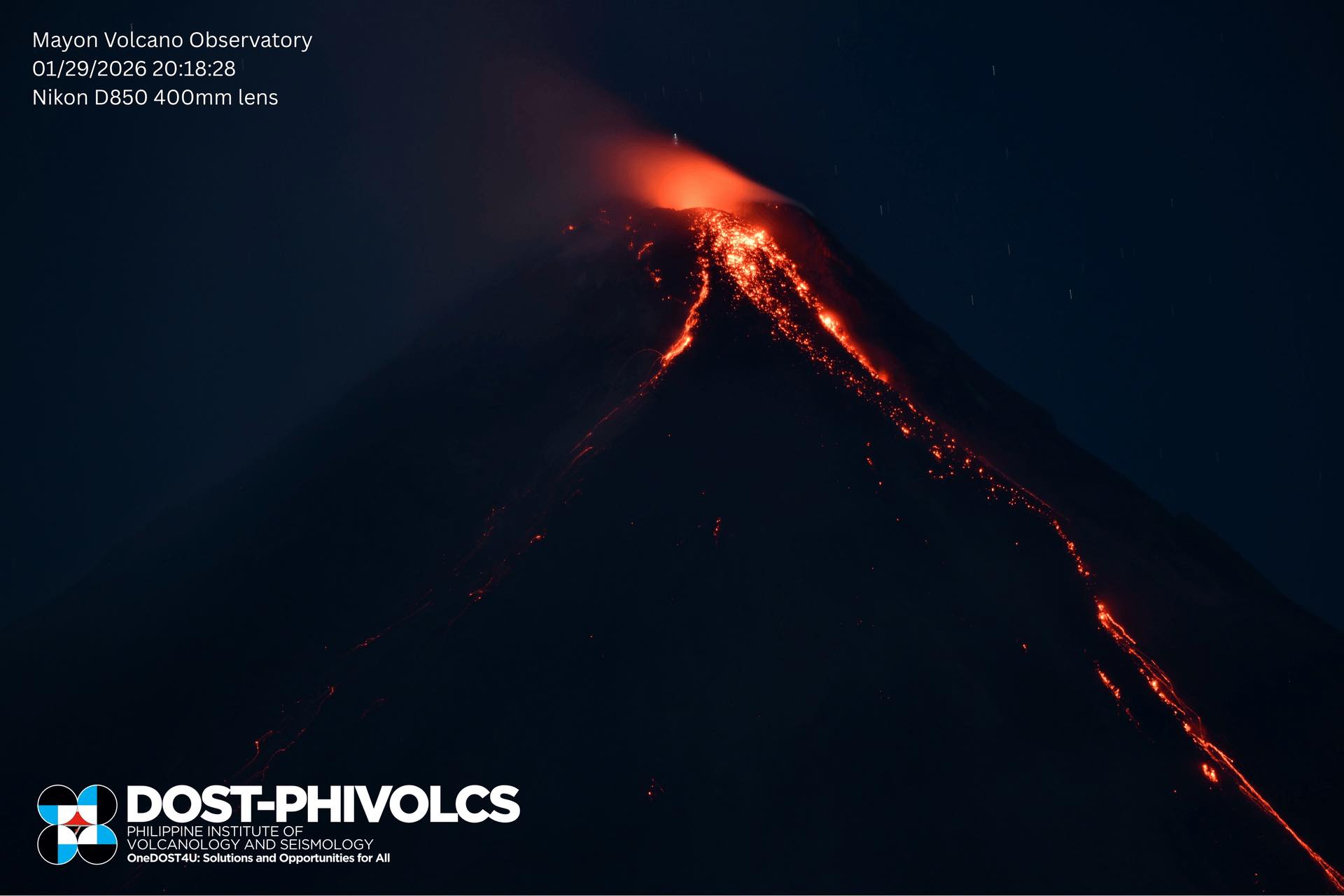
The number of daily volcanic earthquakes was variable; 222-293 daily volcanic earthquakes were recorded during 21-22 and 26-27 January, none were detected on 23 January, one was detected on 24 January, and 13 were detected on 25 January. A period of ongoing tremor occurred during 24-25 January. Sulfur dioxide emissions averaged 1,221-3,364 tonnes per day (t/d) on most days, though emissions peaked at an average of 6,110 t/d on 23 January.
By 18h00 on 28 January a total of 4,055 people (1,115 families) were staying in 13 evacuation shelters, and an additional 51 people (17 families) were staying with friends or relatives, according to the Disaster Response Operations Monitoring and Information Center (DROMIC). The Alert Level remained at 3 (on a 0-5 scale) and residents were reminded to stay away from the 6-km-radius Permanent Danger Zone (PDZ). PHIVOLCS recommended that civil aviation authorities advise pilots to avoid flying close to the summit.
Sources: Philippine Institute of Volcanology and Seismology (PHIVOLCS), Disaster Response Operations Monitoring and Information Center (DROMIC), GVP.
Photo : Phivlocs.
Vanuatu Archipelago , Ambae :
The Vanuatu Meteorology and Geohazards Department (VMGD) reported eruptive activity at Ambae during January based on seismic records, satellite data, and webcam images. Seismic activity was characterized by volcanic tremor and several volcano-seismic events. Sulfur dioxide emissions at variable rates were identified in satellite images on 1 and 28 January. Low- to moderate-intensity thermal anomalies were also detected in satellite images during 2, 4, 6, 15-16, 19, 22, and 26 January. Emissions consisting of various combinations of steam, gas, and ash were visible in satellite and webcam observations during 3-5, 8, 12-15, 18, and 22-23 January. A dense ash plume was visible in a webcam image rising above the crater rim and drifting SSE at 09h15 on 22 January.
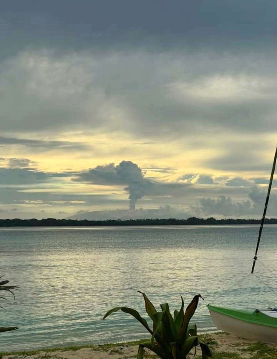
According to the Wellington Volcanic Ash Advisory Center (VAAC) the ash plume rose to 3 km (10,000 ft) a.s.l. and drifted SE based on webcam images and weather models. Ground-based observations at 15h51 indicated that the eruption had continued and a small area of higher-altitude ash to the SW was visible. Ash was not identified in satellite data at either time due to weather-cloud cover. The Alert Level remained at 2 (on a scale of 0-5), and the public was warned to stay outside of Danger Zone A, defined as a 2-km radius around the active vents in Lake Voui, and to stay away from drainages during heavy rains.
Sources: Vanuatu Meteorology and Geohazards Department (VMGD), Wellington Volcanic Ash Advisory Center (VAAC), GVP.
Photo : Mayumi Green / Tatum José.
Colombia , Chiles / Cerro Negro :
San Juan de Pasto, January 27, 2026, 5:40 PM
Regarding the monitoring of activity at the Chiles-Cerro Negro Volcanic Complex (CVCCN), the Colombian Geological Survey (SGC), an agency under the Ministry of Mines and Energy, reports the following:
During the period from January 20 to 26, 2026, the main variations in monitored parameters compared to the previous week were as follows:
● An increase in the number of earthquakes and a decrease in the seismic energy released were recorded. Seismicity related to rock fracturing remains predominant, as does seismicity associated with fluid dynamics within the volcanoes.
● Almost all of the earthquakes were located in the southwest sector of the summit of Chiles volcano, in an area approximately 3 km in diameter, at depths between 2 and 5 km below its summit (4,700 m altitude). The maximum magnitude of this seismicity was 1.8. No earthquakes were felt.

● Analysis of data collected by satellite sensors and ground stations continues to indicate variations related to deformation processes in certain sectors of the volcanic zone.
Based on the assessment and correlation of monitored parameters, the SGC recommends closely monitoring its evolution through weekly bulletins and other information published via its official channels, as well as instructions from local and departmental authorities and the National Disaster Risk Management Unit (UNGRD).
Volcanic activity remains at the yellow alert level: Active volcano with changes in the baseline behavior of monitored parameters and other manifestations.
Source et photo : SGC.