January 26 , 2026.
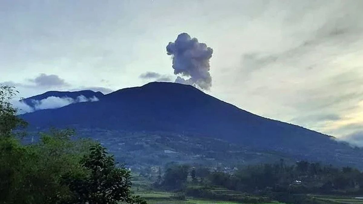
Indonesia , Marapi :
Mount Marapi exhibited an eruption on Monday, January 26, 2026 at 11:11 AM, Indonesian West Time. An ash column was observed approximately 600 meters above the summit (at an altitude of about 3,491 meters). This ash column was gray and dense, drifting northeast. The eruption was recorded by a seismograph with a maximum amplitude of 30.4 mm and a duration of 34 seconds.
VOLCANO OBSERVATORY NOTICE FOR AVIATION – VONA
Issued : January 26 , 2026
Volcano : Marapi (261140)
Current Aviation Colour Code : ORANGE
Previous Aviation Colour Code : orange
Source : Marapi Volcano Observatory
Notice Number : 2026MAR014
Volcano Location : S 0 deg 22 min 52 sec E 100 deg 28 min 23 sec
Area : West Sumatra, Indonesia
Summit Elevation : 9251 FT (2891 M)
Volcanic Activity Summary :
Eruption with volcanic ash cloud at 04h11 UTC (11h11 local).
Volcanic Cloud Height :
Best estimate of ash-cloud top is around 11171 FT (3491 M) above sea level or 1920 FT (600 M) above summit. May be higher than what can be observed clearly. Source of height data: ground observer.
Other Volcanic Cloud Information :
Ash cloud moving to northeast. Volcanic ash is observed to be gray. The intensity of volcanic ash is observed to be thick.
Remarks :
Eruption recorded on seismogram with maximum amplitude 30.4 mm and maximum duration 34 second.
Source et photo : Magma Indonésie .
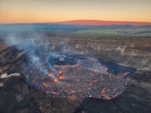
Hawaii , Kilauea :
HAWAIIAN VOLCANO OBSERVATORY DAILY UPDATE , U.S. Geological Survey
Sunday, January 25, 2026, 9:30 AM HST (Sunday, January 25, 2026, 19:30 UTC)
19°25’16 » N 155°17’13 » W,
Summit Elevation 4091 ft (1247 m)
Current Volcano Alert Level: WATCH
Current Aviation Color Code: ORANGE
Activity Summary:
Kīlauea is not erupting. Summit eruption episode 41 lava fountaining began yesterday January 24 at 11:10 a.m. HST, and ended over 8 hours later, at 7:29 p.m., after reaching maximum heights of about 460 to 480 m (1500 to 1575 feet). Preliminary data indicate the onset of the next lava fountaining episode is likely about 2 to 3 weeks away. No significant activity has been noted along Kīlauea’s East Rift Zone or Southwest Rift Zone.
Summit Observations:
Episode 41 fountaining stopped at 7:29 p.m. UTC last night (January 24) and the Halemaʻumaʻu eruption is currently paused. Lava flows on the floor of Halemaʻumaʻu crater continued to move and have small crustal overturns overnight. Continued creeping and incandescence may continue for the next several days. Both glow from the vents and seismic tremor continue and the UWD tiltmeter recorded 3.3 microradians of inflation overnight. There have been no swarms of micro-seismicity since the end of episode 41.
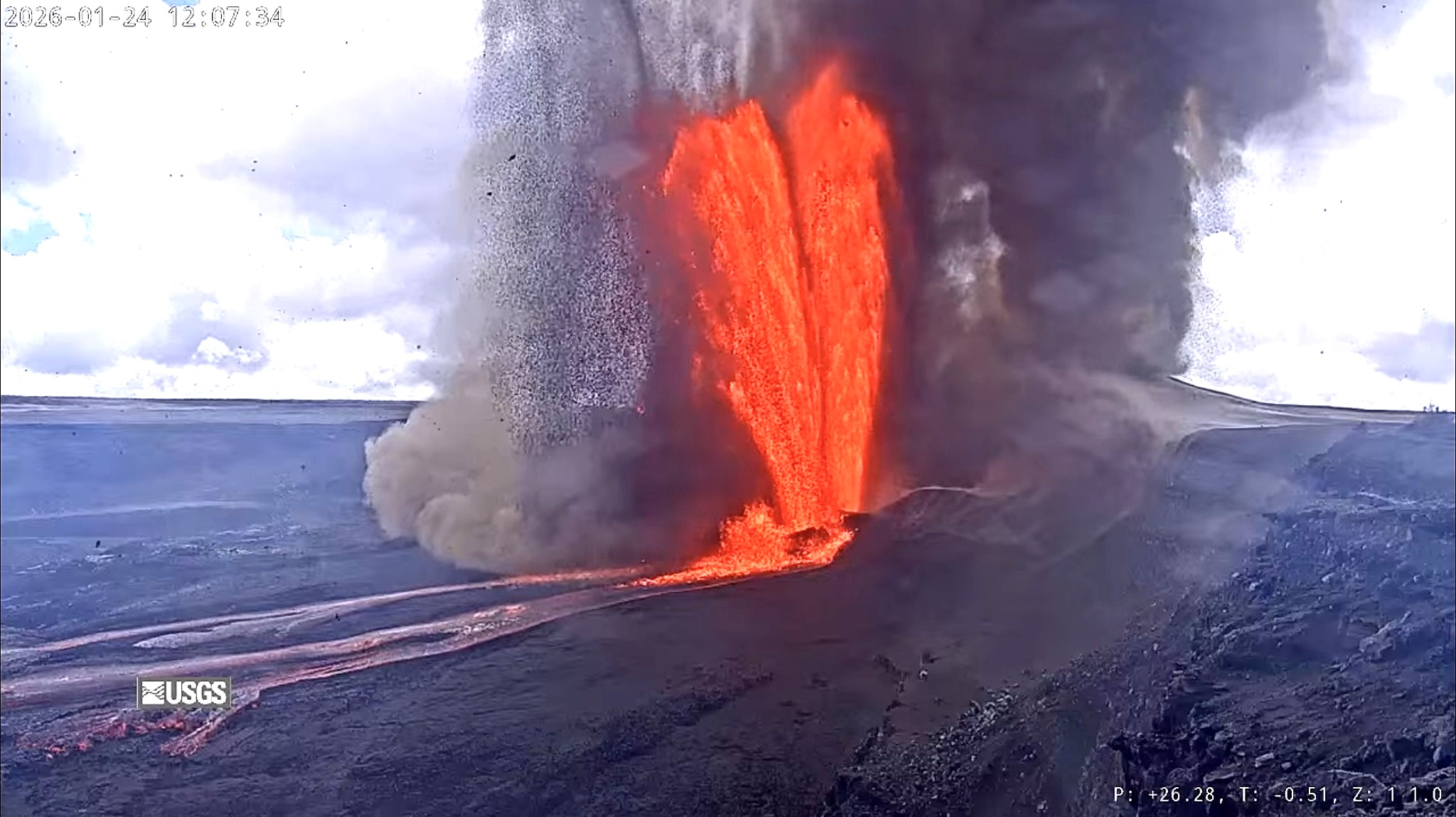
Episode 41 of the ongoing Halemaʻumaʻu eruption began around 11:10 a.m. HST on January 24, 2026, marked by a sharp increase in tremor and deflationary tilt at UWD. North and south vent fountain heights peaked just after 12:30 p.m., with maximum fountain heights estimated around 460 to 480 m (1500 to 1575 feet). Widespread tephra fall was reported in the National Park and surrounding areas including communities to the north of the National Park with fine ash reported falling as far away as Hilo and coastal areas of Puna. Fountains from both vents remained relatively close in size during the eruption but began slowly declining after 1:00 p.m. HST.
Episode 41 lava fountaining from the north vent stopped at approximately 7:26 p.m. HST on January 24. The south vent dropped rapidly, then jetted back up for 30 seconds just prior to the eruption ceasing at 7:29 p.m. HST January 24. Episode 41 ended after 8 hours and 18 minutes with both the north and south vents active for most of the eruption.
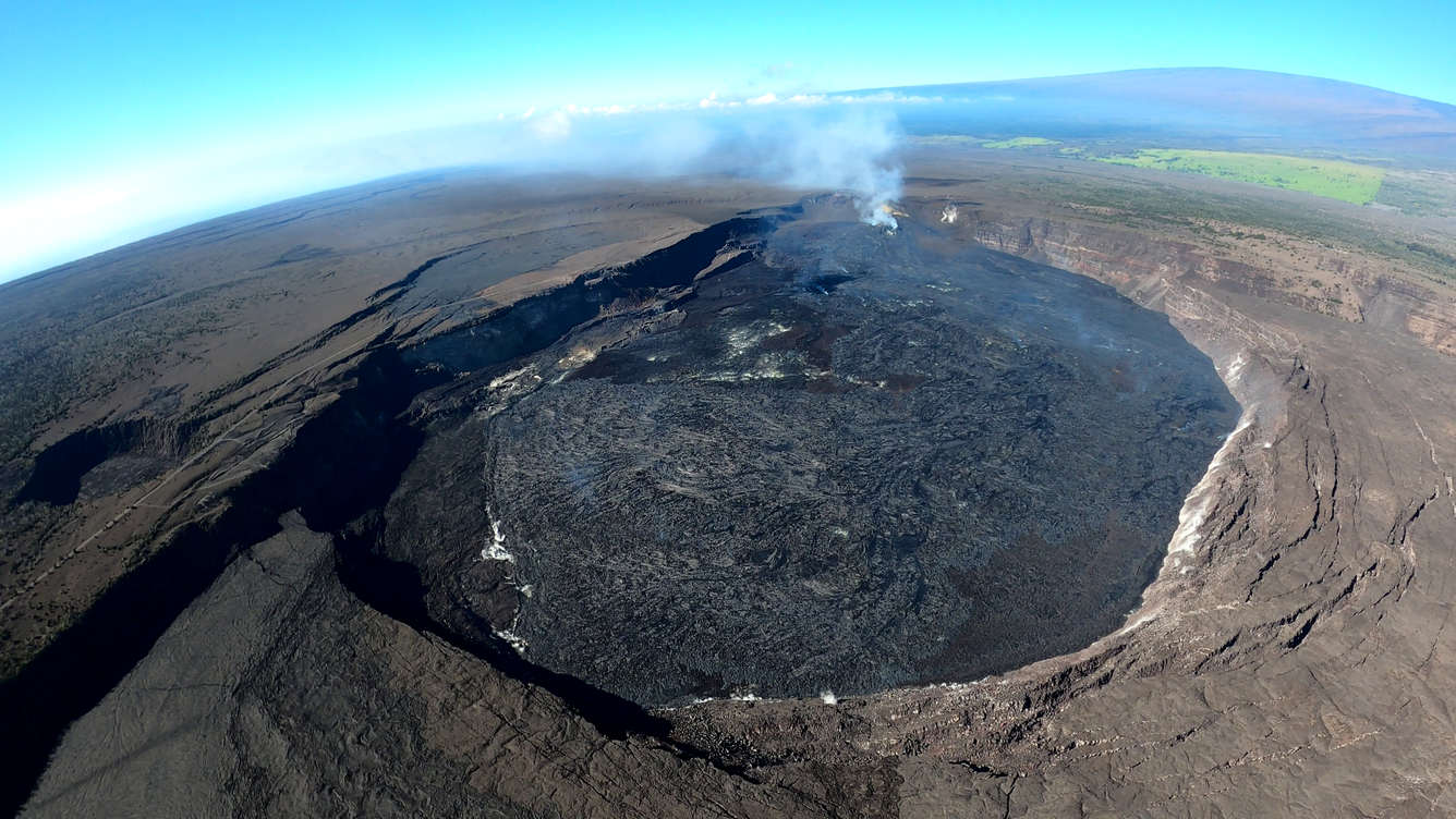
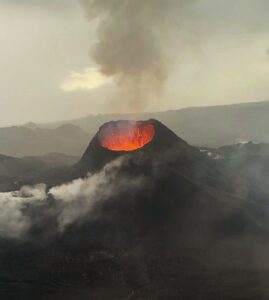
On Friday, January 16, USGS Hawaiian Volcano Observatory geologists conducted an overflight of Kīlauea summit to map the effects of episode 40 and collect samples of the lava. This wide-angle photo shows the episode 40 flows reaching the crater wall in the foreground, with the vents in the distance. A passive outgassing plume originates from the vents and is carried southwest in the tradewinds. Mauna Loa is visible in the upper right portion of the photo.
The highest peak or instantaneous effusion rate of 1050 cubic yards (800 cubic meters) per second occurred just after 12:30 p.m. HST on January 24. Episode 41 ended with an average effusion rate of 470 cubic yards per second (360 cubic meters per second). An estimated 14 million cubic yards (11 million cubic meters) of lava erupted and covered about 80-85% of Halemaʻumaʻu crater floor. The Uēkahuna tiltmeter (UWD) recorded about 31 microradians of deflationary tilt during episode 41.
Tephra was reported in communities including Volcano Village, Mauna Loa Estates, Ohia Estates, Mountain View, Fern Acres, Kurtistown, Ainaloa Estates, Hilo, Hawaiian Paradise Parks, Hawaiian Beaches, and Pahoa. Tephra fall in more distant communities (Mountain View, Fern Acres, Kurtistown, Ainaloa Estates, Hilo, Hawaiian Paradise Parks, Hawaiian Beaches, and Pahoa) is fine-grained ash and Pele’s hair.
The sulfur dioxide (SO2) emission rate from the summit was last measured on January 14 at 1,550 tonnes per day, which is within the typical range of 1,000 to 5,000 tonnes of SO2 per day observed during previous eruptive pauses. This is considerably lower than rates observed during lava fountaining episodes.
Source : HVO
Photos : USGS , USGS/ M. Patrick.
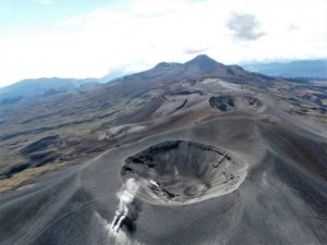
Colombia , Cumbal :
San Juan de Pasto, January 20, 2026, 4:30 PM
Regarding the monitoring of activity at the Cumbal Volcanic Complex (CVC), the Colombian Geological Service (SGC), an agency under the Ministry of Mines and Energy, reports the following:
During the week of January 13-19, 2026, the main variations in monitored parameters compared to the previous week were as follows:
● A slight increase in the number of earthquakes was recorded, accompanied by a slight decrease in their energy. The seismicity is primarily due to rock fracturing within the volcanic edifice.
● Three low-energy earthquakes, with a maximum magnitude of 1.0, were located within the volcanic complex.
● Low gas emissions have been observed at the Rastrojos and Boca Vieja fumarole fields, located southwest of the CVC. Their dispersion is variable due to the wind.
● Other volcanic monitoring parameters remained stable.
Therefore, the SGC recommends closely monitoring the situation by consulting the weekly bulletins and other information disseminated through its official channels, as well as the instructions of local and departmental authorities and the National Disaster Risk Management Unit (UNGRD).
Volcanic activity remains at the yellow alert level: active volcano exhibiting changes in the baseline behavior of monitored parameters and other manifestations.
Source et photos : SGC.
Ecuador , El Reventador :
REVENTADOR VOLCANO DAILY STATE REPORT, Sunday, January 25, 2026.
Information Geophysical Institute – EPN.
Surface Activity Level: High, Surface Trend: No Change
Internal Activity Level: Moderate, Internal Trend: No Change
From January 24, 2026, 11:00 AM to January 25, 2026, 11:00 AM:
Seismicity:
The table below shows the number of seismic events recorded at the reference station:
Explosion (EXP) 75
Long Period (LP) 7
Emission Tremor (TREMI) 4
Harmonic Tremor (TRARM) 3

Rainfall/Lahars:
No rainfall has been recorded in the volcano area. **Heavy rains could remobilize accumulated material, generating mudflows and debris flows that would cascade down the volcano’s flanks and into nearby rivers.**
Emissions/Ash:
This morning, the GOES-19 satellite system detected a gas and ash plume reaching an altitude of 800 meters above the crater, drifting southwest.
Related to this activity, the Washington VAAC agency issued a report indicating an emission reaching an altitude of 1,000 meters above the crater, also drifting southwest.
Gas:
The MOUNTS satellite system measured 12.7 tonnes of sulfur dioxide (SO₂) on January 24, 2026, at 1:18 p.m. local time.
Note:
From yesterday afternoon until the time of writing this report, the volcano remained mostly covered in clouds.
Alert Level – SGR: Orange
Source et photo : IGEPN.
La Réunion Island , Piton de la Fournaise :
Press release from the Paris Institute of Earth Physics / Piton de la Fournaise Volcanological Observatory, January 23, 2026 – 9:00 AM local time – 5:00 AM UTC
Following the cessation of the eruption on January 20, 2026, at approximately 5:00 AM local time, seismic activity is still being recorded beneath the summit of the volcano, but it is decreasing. The following earthquakes were recorded:
– January 19, 2026: 307 summit volcano-tectonic earthquakes,
– January 20, 2026: 153 summit volcano-tectonic earthquakes,
– January 21, 2026: 36 summit volcano-tectonic earthquakes,
– January 22, 2026: 30 summit volcano-tectonic earthquakes.
These earthquakes remain localized between 1 and 2.5 km deep below the northern edge of the summit area of the volcano.
In parallel, long-period (LP) earthquakes have continued to be recorded since the end of the eruption. This type of earthquake is generally associated with deep fluid circulation or pressure variations within the magmatic or hydrothermal system.
This seismic activity (VT and LP) indicates that the volcano’s surface magma supply system remains under pressure.
Inflation of the summit area appears to be resuming, but this parameter will need to be confirmed in the coming days.
It should be noted that during these pressurization phases, seismic activity beneath Piton de la Fournaise can fluctuate daily, with periods of low seismicity interspersed with periods of higher seismicity.
At this stage, the pressurization process of the shallow reservoir can continue for several days to several weeks, or even several months, before a new injection of magma occurs towards the surface; it can also cease without leading to an eruption in the short term.
Current alert level: 2.1
Recommendation: Transition to safeguard phase
Source : OVPF.
Photo : clicanoo