January 21 , 2026.
Italy / Sicily , Etna :
WEEKLY BULLETIN, January 12, 2026 to January 18, 2026. (Publication date: January 20, 2026)
SUMMARY OF ACTIVITIES
Based on monitoring data, the following points should be noted:
1) VOLCANOLOGICAL OBSERVATIONS: Variable rate of degassing at summit craters.
2) SEISMOLOGY: No seismic activity related to fracturing (Ml ≥ 2.0). Tremor amplitude: weak to moderate.
3) INFRASOUND: Moderate infrasound activity.
4) GROUND DEFORMATION: During the week, ground deformation monitoring networks showed no significant variation.
5) GEOCHEMISTRY: SO₂ flux: average level.
CO₂ flux from the ground (EtnaGas Network): low values, similar to those of the previous week. Partial pressure of dissolved CO₂ in groundwater (EtnaWater Network): no update.
Helium isotope ratio at peripheral sites: average values decreasing (latest data from December 22).
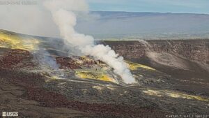
6) SATELLITE OBSERVATIONS: Over the past week, thermal activity observed by satellite in the summit area has been generally low.
VOLCANOLOGICAL OBSERVATIONS
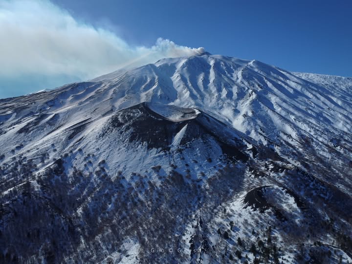
During the week in question, Etna’s volcanic activity was monitored through the analysis of images from the INGV – Osservatorio Etneo (INGV-OE) surveillance cameras, satellite imagery, and direct field observations conducted by INGV-OE staff on January 13. Surveillance camera observations were suspended from January 16 due to adverse weather conditions affecting the summit area.
The analysis of surveillance camera and satellite images showed, in particular, that the effusive eruption that began on January 1 in the Valle del Bove (see report no. 03/2026 ETNA) ceased during the night of January 11–12. Indeed, field and drone surveys carried out on January 13 showed that the entire lava flow was cooling, as was the effusive vent located at an altitude of 2,100 m.
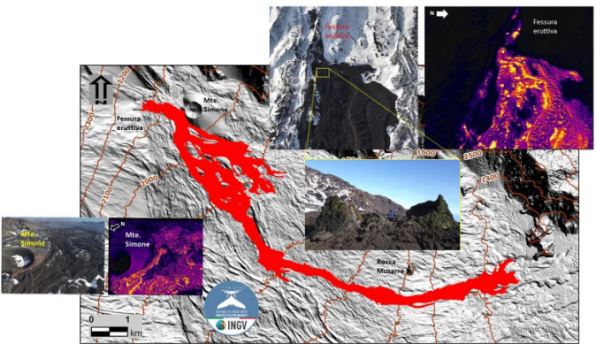
The lava flow map was created from the orthomosaic obtained by processing images from two drone surveys conducted on January 9 and 13. The lava flow extends over 3,150 m, with its furthest front located at an altitude of 1,365 m. The flow covered an area of 0.5 km², and the volume of ejected material is estimated at 4 million m³. It should be noted that this volume estimate is still preliminary, with a margin of error of 40%.
Regarding the summit craters, during the week in question, they were affected by intense degassing activity, primarily impacting the Northeast Crater (which was formed impulsively), as well as the Voragine and Bocca Nuova craters. The degassing activity at the Voragine crater was characterized by intermittent and weak flashes of eruption.
Source : INGV
Photos: Gio Giusa , INGV.
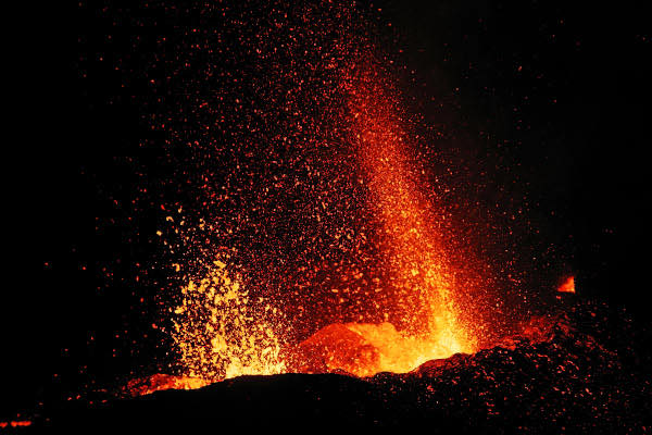
Italy , Stromboli :
WEEKLY BULLETIN, January 12, 2026 to January 18, 2026. (Publication date: January 20, 2026)
SUMMARY OF ACTIVITIES
Based on monitoring data, the following points should be noted:
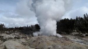
1) VOLCANOLOGICAL OBSERVATIONS: During this period, ordinary Strombolian-type eruptive activity was observed. The total hourly frequency varied between average values (9 events/hour) and high values (22 events/hour). The intensity of the explosions was mainly low to medium in the North and Central-South crater areas.
2) SEISMOLOGY: The monitored seismic parameters showed no significant variation.
3) GROUND DEFORMATION: The ground deformation monitoring networks showed no significant variation.
The tilt measurement network is still affected by disturbances that compromise its reliability.
4) GEOCHEMISTRY: SO2 flux at an average level.
CO2 flux from the ground in the Pizzo area (STR02) at high values.
C/S ratio in the feather at average values.
Helium isotope ratio (R/Ra) dissolved in the thermal aquifer: No update. Latest data from 12/12/2025: high values (4.44).
CO₂ flux from the ground in the San Bartolo area: high values.
CO₂ flux from the ground in the Scari area: almost stable at approximately 120 g/m²/day.
5) SATELLITE OBSERVATIONS: Satellite-observed thermal activity in the summit area was generally low, with a few isolated thermal anomalies of moderate intensity.
VOLCANOLOGICAL OBSERVATIONS
During the observation period, Stromboli’s eruptive activity was characterized by analyzing images recorded by the INGV-OE monitoring cameras located at 190 m (SCT-SCV) and at Punta dei Corvi (SPCT). The explosive activity was primarily due to five eruptive vents located in the northern zone of the crater and at least two vents located in the central-southern zone.
Due to thick cloud cover on January 18, the crater terrace was not visible for a sufficient number of hours to accurately describe the eruptive activity.
Observations of explosive activity captured by surveillance cameras:
Five active vents were observed in the North Crater area, two in sector N1 and three in sector N2, producing explosive activity of low (less than 80 m high) and medium (less than 150 m high) intensity. The eruptive products were primarily coarse material (bombs and lapilli). The average frequency of explosions ranged from 8 to 16 events/h.
Two main vents were observed in the Central-South Crater area, exhibiting explosions of fine material mixed with coarse material and explosions of coarse material of low to medium intensity, respectively. The average frequency of explosions ranged from 0 to 6 events/h.
Source : INGV
Photo : Stromboli stati d’animo / Sebastiano Cannavo
Colombia , Nevado del Ruiz :
Manizales, January 20, 2026, 5:00 PM
Regarding the monitoring of activity at the Nevado del Ruiz volcano, the Colombian Geological Survey (SGC), an agency under the Ministry of Mines and Energy, reports that:
During the week of January 13-19, 2026, the volcano continued to exhibit unstable behavior. The main variations in monitored parameters compared to the previous week are as follows:
– Seismicity related to fluid dynamics in the volcanic conduits increased, both in the number of recorded earthquakes and in the seismic energy released; however, energy levels remained low. During the week, long-duration, low-energy signals were again recorded, sometimes slightly higher than those of previous weeks, reaching values not seen since November 2025. In addition, thanks to the cameras (conventional and thermographic) used to monitor the volcano, several pulsed ash emissions, associated with short-duration signals, were confirmed, as well as variations in the apparent temperature of the materials emitted during these emissions.

Seismic activity related to rock fracturing within the volcanic edifice increased slightly, both in the number of recorded earthquakes and in the seismic energy released. These earthquakes were primarily located in the Arenas crater, to a depth of 2 km, and on the south-southeast and northwest flanks of the volcano, within 3 km of the crater and at depths between 2 and 7 km. To a lesser extent and sporadically, earthquakes occurred on the other flanks of the volcano, more than 3 km from the crater, and mainly within 11 km, at depths between 2 and 8 km. The maximum magnitude of the week was 1.7, corresponding to the earthquake recorded on January 19 at 6:34 a.m., located 2 km south-southeast of the crater, at a depth of 4 km below the summit of the volcano.
– The emission of water vapor and volcanic gases, primarily sulfur dioxide (SO₂), into the atmosphere continued through the Arenas crater. Estimated daily SO₂ flux rates showed variability, with some low values and others similar to those of the previous week. These low SO₂ levels were partly due to unfavorable wind direction and speed for the monitoring stations. Further monitoring using satellite data also observed low SO₂ emissions.
The height and dispersion of the gas, vapor, or ash plume remained generally between 300 and 400 m above the volcano’s summit; however, on January 13, it reached a maximum height of 800 m. Regarding the dispersion direction, the plume varied along the volcano’s flanks, primarily toward the north-northwest flank and, to a lesser extent, toward the southwest flank.
Thermal anomalies at the bottom of the Arenas crater remained weak. Satellite monitoring continued to be limited by thick cloud cover in the volcanic area.
Source et photo : SGC.
Peru , Ubinas :
Local date and time: January 20, 2026, 5:27 PM
Location: Volcanmayo Ravine (southeast flank of Ubinas Volcano)
Potentially impacted areas: Ubinas and Matalaque districts and surrounding areas.
Observations
The lava flow is a cold mixture of water and volcanic sediments (ash, rock fragments, erratic boulders, etc.).
Recommendations
a) To the public: Stay away from the ravine and avoid using the Querapi-Ubinas-Huarina road for the time being.
b) To authorities: Conduct an assessment of the lava flow’s impact on towns and areas near the ravine, as well as on roads and irrigation infrastructure (reservoirs and canals).

A lahar occurred this afternoon in the Volcanmayo ravine, on the southeast flank of the Ubinas volcano, located in the province of General Sánchez Cerro, department of Moquegua, according to the Geophysical Institute of Peru (IGP).
The lahar began at 5:27 p.m. and the flow is heading toward the Ubinas River. The districts of Ubinas and Matalaque, as well as surrounding areas, are potentially affected.
The National Institute of Civil Protection (Indeci) recommends activating your family emergency plan and evacuating via designated evacuation routes to safe areas.
In addition, stay away from ravines where lahars or mudflows are occurring; avoid approaching ravines or gullies near the volcano where lahar flows are flowing. Avoid driving on access roads that cross ravines or gullies near the volcano.
A few days ago, the IGP reported a volcanic mudflow in the El Volcán ravine, in the southern sector of the Huaynaputina volcano, also in the department of Moquegua.
Sources : Cenvul , Andina .
Photo : IGP.
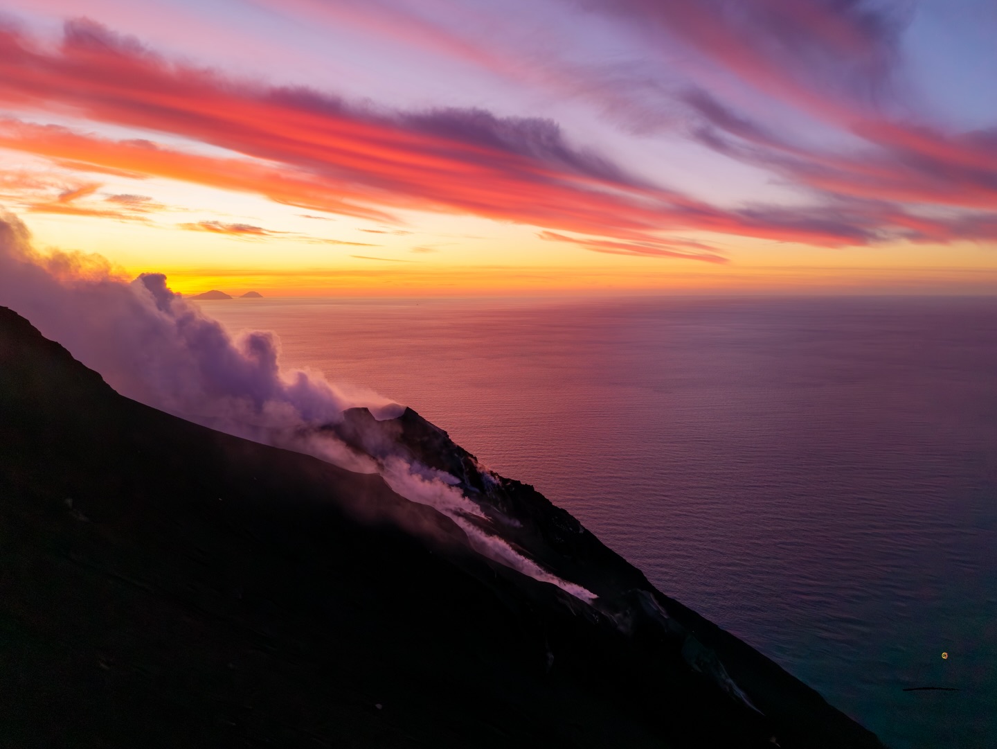
La Réunion Island , Piton de la Fournaise :
Press release from the Paris Institute of Earth Physics, Piton de la Fournaise Volcanological Observatory. January 21, 2026 – 9:30 a.m. local time – 5:30 a.m. UTC
Following the cessation of the eruption on January 20, 2026, at approximately 5:00 a.m. local time, seismic activity is still being recorded beneath the summit of the volcano, but it has been decreasing over the past 16 hours, dropping from 10 shallow volcano-tectonic earthquakes per hour to an average of 3, a rate similar to that observed before the eruption.
These earthquakes remain localized at a depth of approximately 2 km below the summit of the volcano. This seismic activity indicates that the volcano’s shallow magma system remains under pressure, but the hypothesis of an imminent resumption of activity is diminishing.
At this stage, the pressurization process of the shallow reservoir can continue for several days to several weeks, or even several months, before a new injection of magma occurs towards the surface; it can also cease without leading to an eruption in the short term.
It should be noted that during the night, the red glow of the lava flows faded, indicating that the surface of the flows was cooling. Nevertheless, the core of the flows can remain hot for several months, and fumaroles persist. The intensity of the fumaroles can increase after periods of rain.
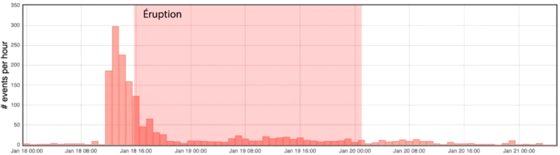
Histogram showing the number of shallow volcano-tectonic earthquakes per hour recorded between January 18 and 21, 2026. The duration of the eruption is indicated in red (© OVPF-IPGP).
Current alert level: 2.1
Source : direction de l’OVPF-IPGP.
Photos : OVPF.