La Réunion Island , Piton de la Fournaise :
January 18, 2026 – 5:00 PM local time – 1:00 PM UTC
Seismic Crisis
Since approximately 4:34 PM local time, a seismic crisis has been recorded by the instruments at the Piton de la Fournaise Volcanological Observatory. This seismic crisis is accompanied by rapid deformation. This indicates that magma is leaving the magma chamber and propagating towards the surface.
An eruption is likely in the near future, within the next few minutes or hours.
Further information will follow regarding the area impacted by this magma propagation towards the surface.
Recommended alert level: Alert 1
Since 4:34 PM this Sunday, January 18, 2026, the Piton de la Fournaise Volcanological Observatory has recorded a seismic crisis at the volcano, indicating that magma is rising towards the surface.
Consequently, and due to a probable or imminent eruption, the Prefect of Réunion has activated alert level 1 and ordered the closure of the caldera today.
Press release from the Paris Institute of Earth Physics / Piton de la Fournaise Volcanological Observatory, January 18, 2026 – 7:55 PM local time – 3:55 PM UTC
Eruption begins
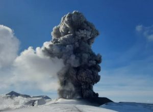
Following the seismic crisis that began at 4:34 PM local time, volcanic tremor, indicating the arrival of magma near the surface, has been recorded since approximately 7:42 PM local time.
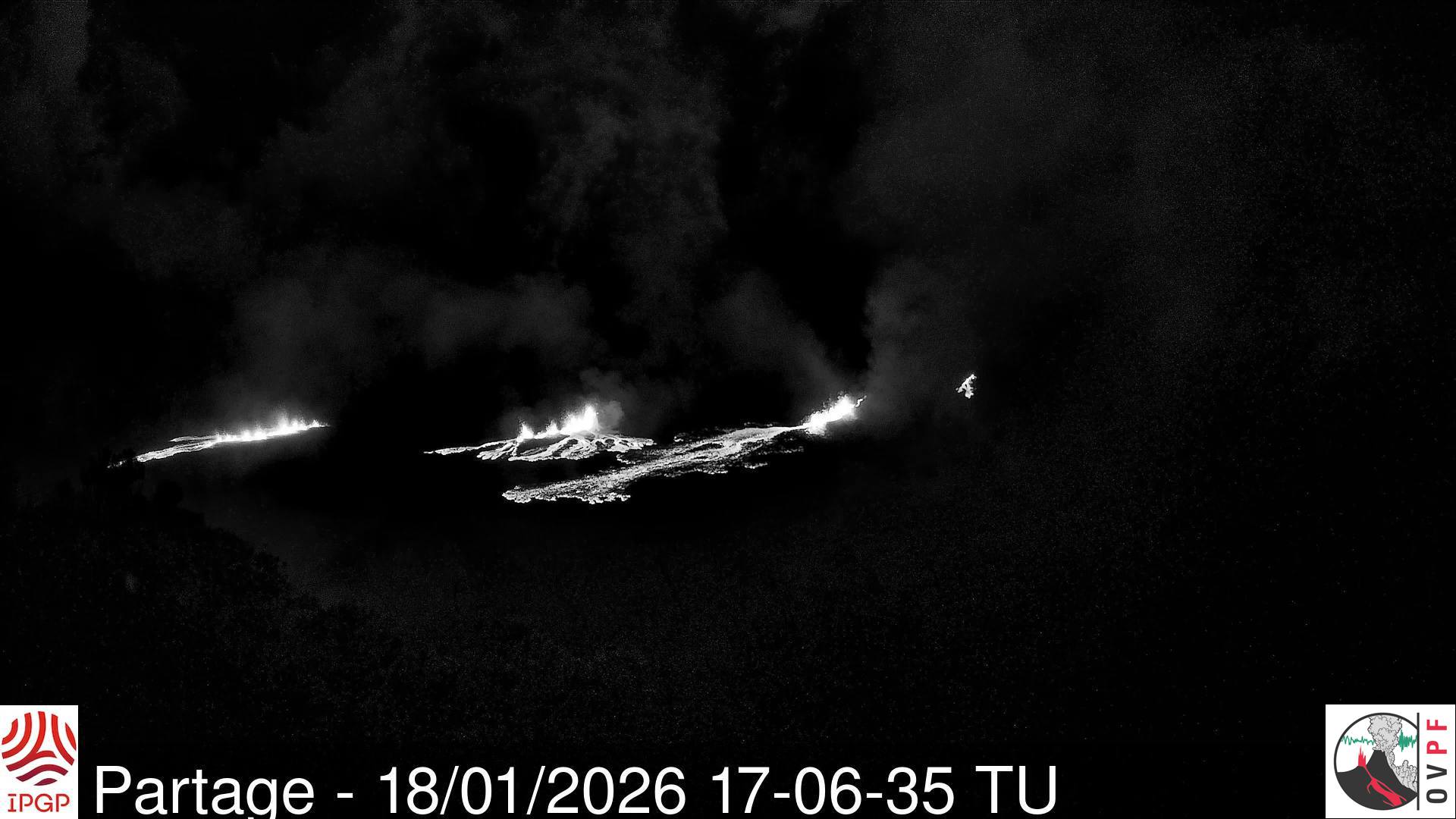
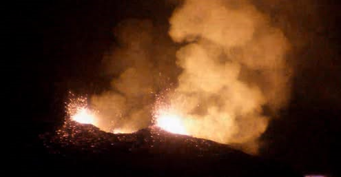
Analysis of the data and observations from our cameras show that the eruptive fissure(s) have opened on the northern flank of the volcano, within the Enclos. The first visible images of the eruption appeared at 7:48 PM (3:48 PM UTC) on the OVPF webcam located at Piton Partage.
Eruption in progress.
Recommended alert level: Alert 2-1 (eruption within the Enclosure without any particular threat to the safety of people, property or the environment)
OVPF-IPGP Press Release – January 18, 2026, 9:45 PM
Eruption in progress
The eruption that began today at Piton de la Fournaise continues.
Following the opening of the first fissure between 7:45 PM and 7:48 PM local time, three other fissures opened. Two new fissures opened further downstream from the first between 8:33 PM and 8:48 PM; and a fourth fissure opened further upstream around 8:54 PM (local time).
These fissures remain located within the Enclos Fouqué caldera on the northern flank of the Piton de la Fournaise summit cone. The most downstream fissure is located approximately 700 meters from the northern edge of the Enclos Fouqué caldera.
Due to continued seismic activity, further fissure openings remain possible in the coming hours, particularly further downstream. The OVPF-IPGP remains on continuous alert to monitor the situation.
Alert level: Alert 2-1
Colombia , Puracé – Los Coconucos volcanic chain:
Popayán, January 18, 2026, 9:00 AM
Regarding the monitoring of activity in the Los Coconucos volcanic chain, the Colombian Geological Survey (SGC), an agency under the Ministry of Mines and Energy, reports the following:
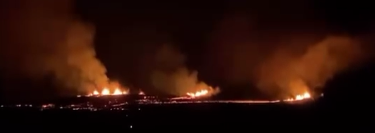
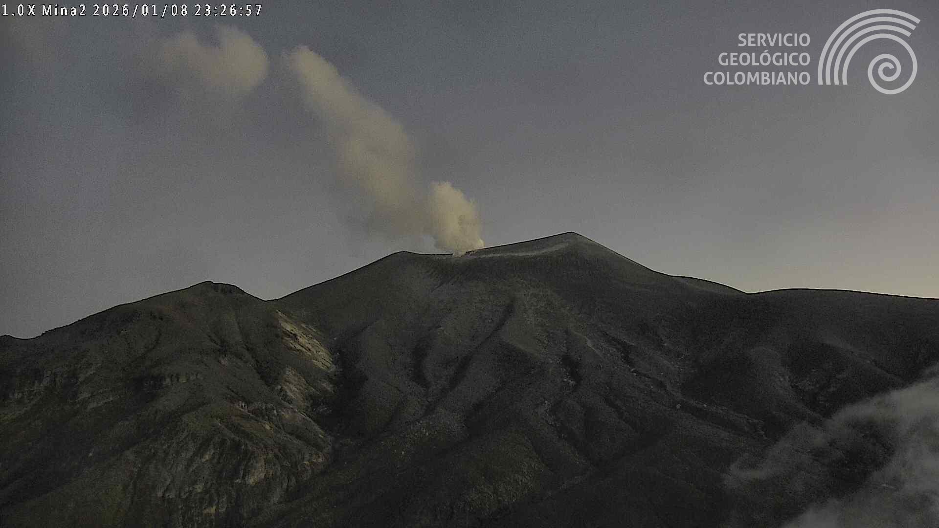
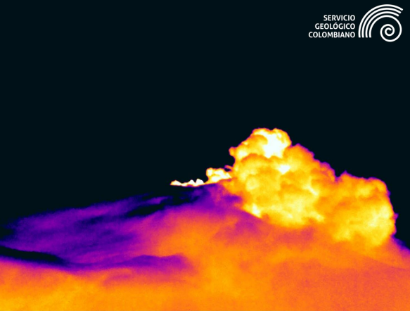
Since the publication of yesterday’s extraordinary bulletin and continuing to this day, earthquakes associated with fluid circulation within the volcanic edifice have continued to occur. These are long-period (LP) tremor (TR) earthquakes. These earthquakes were located beneath the crater of the Puracé volcano, at depths of less than 1 km, and were linked to circulation processes and the release of volcanic gases into the atmosphere. Among these seismic signals, one (1) was associated with an ash emission which dispersed mainly towards the West-Southwest, following the direction of the wind, reaching altitudes of more than 700 m above the summit of the volcano.
In addition, low-magnitude seismic activity, associated with rock fracturing, continued to be recorded. These earthquakes were primarily located beneath the Piocollo volcano, at depths between 1 and 3 km.
Sulfur dioxide (SO₂) emissions continue to be recorded, and gases continue to escape from fissures in the craters of the Curiquinga and Piocollo volcanoes, although no associated ash emissions have been identified to date. Satellite observations indicate a decrease in the intensity of the thermal anomaly in the Puracé volcano crater.
As long as the orange alert level remains in effect, temporary fluctuations in volcanic activity are possible, meaning that it may sometimes decrease compared to previous days or weeks. However, this does not necessarily imply that the volcano has returned to a stable level of activity. Returning to the yellow alert level (greater stability) requires a reasonable time to assess all monitored parameters and identify any trends indicating a resumption of activity.
Recording from the Mina camera, located 2.2 km north of the Puracé volcano, showing an ash emission that occurred on January 18, 2026, at 8:13 PM (local time).
Given the above, the Geological Survey of Colombia (SGC) recommends staying away from the craters of the Puracé, Piocollo, and Curiquinga volcanoes, as well as their surrounding areas. We suggest closely monitoring the situation through special bulletins and information published on our official channels, as well as instructions from local and departmental authorities and the National Unit for Disaster Risk Management (UNGRD).
The volcanic activity level remains at orange alert: Volcano with significant variations in monitored parameters.
Source et photo : SGC.
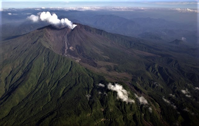
Ecuador , El Reventador :
REVENTADOR VOLCANO DAILY STATE REPORT, Sunday, January 18, 2026.
Information Geophysical Institute – EPN.
Surface Activity Level: High, Surface Trend: No Change
Internal Activity Level: Moderate, Internal Trend: No Change
From January 17, 2026, 11:00 AM to January 18, 2026, 11:00 AM:
Seismicity:
The table below shows the number of seismic events recorded at the reference station:
Explosion (EXP) 84
Long Period (LP) 11
Emission Tremor (TREMI) 4
Harmonic Tremor (TRARM) 6
Rainfall/Lahars:
Rainfall has been recorded in the volcano’s vicinity, but it has not generated any mudflows or debris flows. **In the event of heavy rainfall, accumulated material could be remobilized, causing mudflows and debris flows that would cascade down the volcano’s flanks and into nearby rivers.**
Emissions/Ash:
Using the GOES-19 satellite system, several plumes of gas and ash were observed at an altitude of 800 meters above the crater, drifting west and west-southwest. In this regard, the VAAC agency in Washington issued three reports indicating ash emissions reaching an altitude of 700 meters above the crater, drifting west and west-southwest.
Other monitoring parameters:
Over the past 24 hours, the FIRMS satellite system has recorded four thermal anomalies.
Note:
From yesterday afternoon until the time of writing this report, the volcano has remained shrouded in clouds.
Alert level – SGR: Orange
Source : IGEPN.
Photo : Patricio Ramon, 2005 (Instituto Geofisca, Escuela Politecnica Nacional).
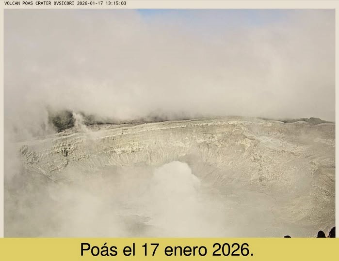
Costa Rica , Poas :
ERUPTION REPORT – OVSICORI-UNA
Coordinates: N10.20 W84.23
Mountain Altitude: 2687 m
Date: January 18, 2026 Time: 5:53 AM
Plume Height: Unknown
Plume Observation Source: Seismographs and Infrasound Acoustic Sensors
Observed Activity:
Fifth minor phreatic eruption of Poás today, January 18, at 5:53 a.m. From Friday, January 16, to January 18, the OVSICORI-UNA volcanic monitoring instruments recorded five moderate-energy phreatic eruptions, characterized by the sudden emission of water vapor, gas, and fine particles (aerosols).
The prevailing wind is blowing from west to east. No ashfall has been reported.
Poás volcano has been experiencing a period of increased phreatic activity and magmatic degassing since the beginning of 2024. It is recommended to follow the guidelines of organizations responsible for volcanic hazard management, such as SINAC and CNE.
Niveau d’activité : Alerte
Source et photo : Ovsicori .
Guatemala , Fuego :
Atmospheric conditions: Clear skies
Wind: East
Precipitation: 0.0 mm
Activity
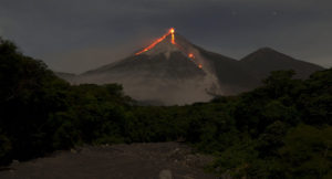
During the night and early morning, weak to moderate degassing was recorded, with fumaroles reaching approximately 300 m above the crater and dispersing westward. Explosive activity continued with 6 to 10 weak to moderate explosions per hour, generating ash columns between 4,300 and 4,700 m altitude, which drifted westward.
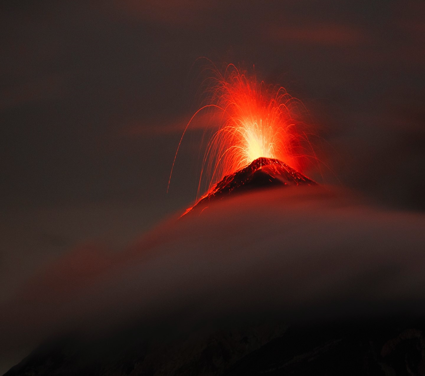
Some explosions were accompanied by short-lived rumbling, shockwaves, and similar noises, like those of a locomotive, associated with the continuous expulsion of gas. Incandescent glows were observed up to 200 m above the crater, linked to small avalanches. Incandescent material was also recorded falling back around the crater, channeling into the ravines of Ceniza, Taniluyá, Seca, Santa Teresa, Trinidad, and Las Lajas, sometimes reaching the vegetation line.
Source : Insivumeh.
Photo : Diego Rizzo .