January 16 , 2026.
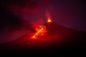
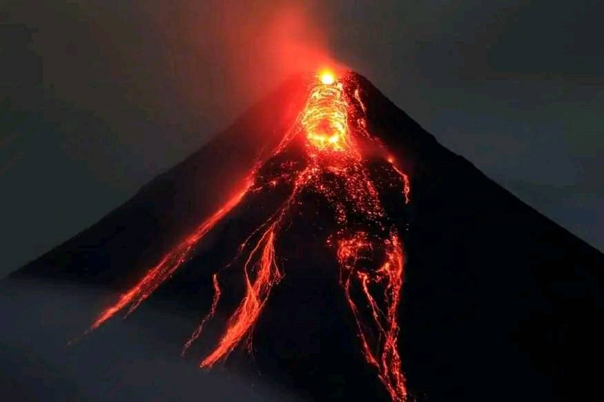
Hawaii , Kilauea :
HAWAIIAN VOLCANO OBSERVATORY INFORMATION STATEMENT , U.S. Geological Survey
Wednesday, January 14, 2026, 10:05 PM HST (Thursday, January 15, 2026, 08:05 UTC)
19°25’16 » N 155°17’13 » W,
Summit Elevation 4091 ft (1247 m)
Current Volcano Alert Level: WATCH
Current Aviation Color Code: ORANGE
On Wednesday, January 14 at 7:35 p.m. HST, a swarm of earthquakes began beneath Halemaʻumaʻu crater at the summit of Kīlauea. Elevated seismic activity gradually died down in frequency of occurrence and intensity, over the course of 40 minutes. Locations of these earthquakes are spread broadly beneath east side of Halemaʻumaʻu crater and the south caldera. All of the detected earthquakes have been less than magnitude-2, with most being magnitude-1 or smaller.
This is the third small swarm of earthquakes beneath Halemaʻumaʻu crater since the end of episode 40. The first swarm began at 12:40 a.m. HST and lasted for 30 minutes on Tuesday, January 13. It was followed the next day by a second swarm around 9:10 a.m. HST, and lasted less than 30 minutes on Wednesday morning, January 14. The first and second swarms both had magnitude ranges similar to the third. Most of the earthquakes seem to be occurring around the shallow Halemaʻumaʻu magma chamber, some 1.5 to 4 km beneath the surface.
Most of the earthquakes are volcano-tectonic earthquakes that accompany crack opening due to magmatic pressure. Elevated seismic activity of these intensities have not been seen at the summit since the start of the eruption in December 2024. A small swarm did precede a new fissure opening in the wall of the Halemaʻumaʻu crater just to the south of the vents, at the start of episode 30. It is yet to be determined if these swarms after episode 40 will have an impact on lava-fountaining activity at the surface.
Volcanic systems remain a complex balance of magmatic pressure and strength of the surrounding rocks. If the rocks weaken, one possible outcome is injection of a magma into a fracture creating a dike. If the magma breaches the surface a new vent might be created shifting the focus of the eruption. Historically, episodic fountain eruptions can cease when the magma supply is diverted in this manner.
Currently all of the activity remains beneath Kīlauea caldera and there is no observable evidence that magma is migrating away from this area. Both the east and the southwest rift zones remain quiet at this time.
The USGS Hawaiian Volcano Observatory will continue to closely track changes in seismic activity and monitor Hawaiian volcanoes for any changes.
Source : HVO.
Photo : H. Winslow
Philippines , Mayon :
The Philippine Institute of Volcanology and Seismology (PHIVOLCS) reported that activity continued at the summit of Mount Mayon from January 8 to 14. Effluents and collapses at the summit produced pyroclastic flows, rockfalls, ash plumes, avalanches of incandescent material, and the beginnings of lava flows. Seismic stations recorded between 72 and 256 rockfalls and between 37 and 100 pyroclastic flows daily; one volcanic earthquake was recorded on January 7 and two more on January 8. Emissions were visible daily, rising up to 1 km above the summit and propagating in several directions. PHIVOLCS noted that lava flows appeared to be forming from January 8 to 10. Real-time seismic amplitude measurement (RSAM) data increased on January 11 due to background tremor, possibly indicating open vent conditions. Although inflation on the eastern flank has continued since June 2024, no increase in deformation has been observed despite the increased seismicity.
Sulfur dioxide emissions remained at background levels, averaging 195 tonnes per day (t/d) on January 8, 777 t/d on January 10, and 526 t/d on January 11. According to the Tokyo Volcanic Ash Advisory Center (VAAC), ash plumes were identified in satellite imagery on January 8, 9, and 11. These plumes rose to altitudes of 2.7 to 3.4 km (9,000 to 11,000 feet), reaching up to 900 m above the summit, and drifted westward and west-southwestward. As of 11:00 a.m. on January 12, 4,092 people (1,116 families) had been evacuated to 14 shelters, and an additional 48 people (15 families) were staying with friends or relatives, according to a report from the Disaster Response Operations Monitoring and Information Center (DROMIC).
Volcanic activity from January 11 to 14 was characterized by dome growth and lava flows. The alert level remained at 3 (on a scale of 0 to 5), and residents were reminded to stay away from the 6-kilometer radius Permanent Danger Zone (PDZ). The Philippine Institute of Volcanology and Seismology (PHIVOLCS) recommended that civil aviation authorities advise pilots to avoid flying over the summit.
Sources: Philippine Institute of Volcanology and Seismology (PHIVOLCS), Disaster Response Operations Monitoring and Information Center (DROMIC), Tokyo Volcanic Ash Advisory Center (VAAC), GVP.
Photo : Lan Po Lan ( archive)
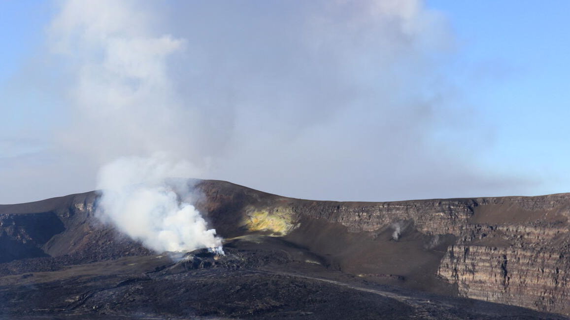
Alaska , Aniakchak :
ALASKA VOLCANO OBSERVATORY INFORMATION STATEMENT , U.S. Geological Survey
Thursday, January 15, 2026, 5:47 PM AKST (Friday, January 16, 2026, 02:47 UTC)
56°54’21 » N 158°12’32 » W,
Summit Elevation 4400 ft (1341 m)
Current Volcano Alert Level: UNASSIGNED
Current Aviation Color Code: UNASSIGNED
Strong surface winds blowing to the northwest in the region northwest of Aniakchak and east of Port Heiden have picked up loose volcanic ash and carried it to the northwest today. A cloud of resuspended volcanic ash is visible in satellite data. The National Weather Service has issued a SIGMET for this low-level event and suggests that the maximum cloud height is 6,000 ft (1.8 km) above sea level.
This phenomenon is not the result of volcanic activity and usually occurs seasonally in the spring and fall during times of high winds and dry, snow-free conditions in volcanic areas of Alaska. No eruption is in progress. Aniakchak remains at color code UNASSIGNED due to a temporary power outage affected monitoring data from the volcano. Resuspended volcanic ash should be considered hazardous and could be damaging to aircraft and health.
Aniakchak volcano, located in the central portion of the Alaska Peninsula, consists of a stratovolcano edifice with a 6 mile (10 km) diameter summit caldera. The caldera-forming eruption occurred around 3,500 years ago. Post-caldera eruptions have produced lava domes, tuff cones, and larger spatter and scoria cone structures, including Half-Cone and Vent Mountain, all within the caldera. The most recent eruption occurred in 1931 and created a new vent and lava flows on the western caldera floor while spreading ash over much of southwestern Alaska. Aniakchak volcano is 16 miles (26 km) southeast of the nearest community, Port Heiden, and 416 miles (670 km) southwest of Anchorage, Alaska.
Source : AVO.
Photo : Mayo, Wyatt / Alaska Volcano Observatory / Alaska Division of Geological & Geophysical Surveys
Japan , Suwanosejima :
The Japan Meteorological Agency (JMA) reported that eruptive activity at Suwanosejima’s Ontake Crater continued during 2-9 January. Incandescence was observed nightly in webcam images. An eruptive event at 2254 on 6 January generated an ash plume that rose 1.2 km above the crater rim and drifted SE. The Alert Level remained at 2 (the second level on a five-level scale) and the public was warned to be cautious within 1.5 km of the crater.
The 8-km-long island of Suwanosejima in the northern Ryukyu Islands consists of an andesitic stratovolcano with two active summit craters. The summit is truncated by a large breached crater extending to the sea on the E flank that was formed by edifice collapse. One of Japan’s most frequently active volcanoes, it was in a state of intermittent Strombolian activity from Otake, the NE summit crater, between 1949 and 1996, after which periods of inactivity lengthened. The largest recorded eruption took place in 1813-14, when thick scoria deposits covered residential areas, and the SW crater produced two lava flows that reached the western coast. At the end of the eruption the summit of Otake collapsed, forming a large debris avalanche and creating an open collapse scarp extending to the eastern coast. The island remained uninhabited for about 70 years after the 1813-1814 eruption. Lava flows reached the eastern coast of the island in 1884. Only about 50 people live on the island.
Sources: Japan Meteorological Agency (JMA) , GVP.
Photo : Photovolcanica ( archive)
Indonesia , Ili Lewotolok :
An eruption of Mount Ili Lewotolok occurred on Friday, January 16, 2026, at 10:10 AM WITA. The observed ash column rose approximately 350 meters above the summit (approximately 1,773 meters above sea level). The thick, gray-black ash column drifted eastward. This eruption was recorded by a seismograph, with a maximum amplitude of 32.1 mm and a duration of 48 seconds.
Seismicity Observations:
390 eruption earthquakes with amplitudes ranging from 16.6 to 36.5 mm and durations from 30 to 110 seconds.
456 emissions earthquakes with amplitudes ranging from 3.7 to 20.7 mm and durations from 30 to 60 seconds.
27 non-harmonic tremors with amplitudes ranging from 4.7 to 22.2 mm and durations of 100 to 210 seconds.
1 local tectonic earthquake with an amplitude of 26.1 mm and a duration of 25 seconds.

Recommendations
1. Residents living around Mount Ili Lewotolok, as well as visitors, climbers, and tourists, are advised to refrain from all activities within a 2 km radius of the Mount Ili Lewotolok activity center, and within a 2.5 km radius of the activity center in the South-Southeast and West sectors.
2. Be vigilant for the risk of lava flows and pyroclastic flows in the South, Southeast, West, and Northeast sectors of Mount Ili Lewotolok. The public is advised not to panic if rumbling or banging sounds are heard from the Mount Ili Lewotolok crater, as these are signs of active volcanic activity.
Source et photo : Magma Indonésie .