December 26 , 2025.
Hawaii , Kilauea :
HVO/USGS Volcanic Activity Notice
Current Volcano Alert Level: WATCH
Current Aviation Color Code: ORANGE
Issued: Tuesday, December 23, 2025, 8:27 PM HST
Source: Hawaiian Volcano Observatory
Notice Number: 2025/H555
Location: N 19 deg 25 min W 155 deg 17 min
Elevation: 4091 ft (1247 m)
Area: Hawaii
Volcanic Activity Summary:
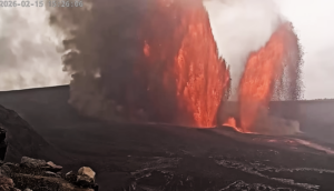
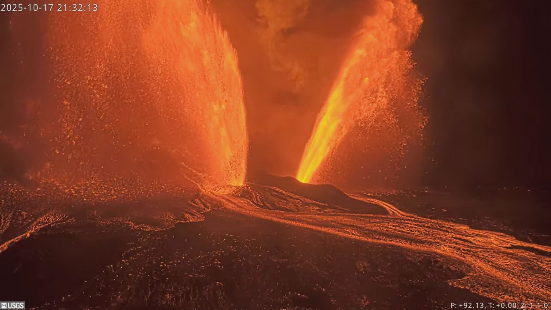
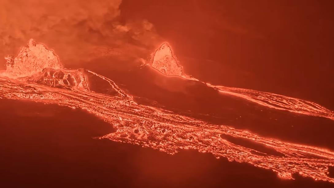
Episode 39 of the ongoing Halemaʻumaʻu eruption began at 8:10 p.m. HST on 23 December. Sustained lava fountains approximately 100 feet (30 meters) in height are currently erupting from both north and south vents. Fountain heights are currently increasing.
Past episodes have produced incandescent lava fountains over 1000 feet (300 meters) high that produce eruptive plumes up to 20,000 feet (6000 meters) above ground level. According to the National Weather Service, winds are blowing from the northeast direction, which suggests that volcanic gas emissions and volcanic material may be distributed to the southwest.
All eruptive activity is confined to Halemaʻumaʻu crater within Hawaiʻi Volcanoes National Park; commercial airports in Hawaii County (KOA and ITO) will not be affected by this activity.
Episode 39 was preceded by overflows of degassed lava that began at approximately 6:41 p.m. from the south vent and continued to increase in intensity until 8:10 p.m., when sustained fountaining began.
Inflationary tilt reached just over 32 microradians since the end of the last episode. Seismic tremor began increasing and tilt at UWD switched from inflationary to deflationary at about 8:10 p.m. HST, about the same time lava flows began erupting onto the crater floor.
Most episodes of Halemaʻumaʻu lava fountaining since December 23, 2024, have continued for around a day or less and have been separated by pauses in eruptive activity lasting generally at least several days.
No changes have been detected in the East Rift Zone or Southwest Rift Zone.
Remarks:
This episodic eruption is occurring within a closed area of Hawai’i Volcanoes National Park. High levels of volcanic gas—primarily water vapor (H2O), carbon dioxide (CO2), and sulfur dioxide (SO2)—are one hazard of concern, as this hazard can have far-reaching effects downwind. As SO2 is continuously released from the summit during an eruption, it will react in the atmosphere to create the visible haze known as vog (volcanic smog) downwind of Kīlauea. SO2 and vog may cause respiratory and other problems at high concentrations.
Issued: Wednesday, December 24, 2025, 2:33 AM HST.
Volcanic Activity Summary:
Episode 39 of the ongoing Halemaʻumaʻu eruption ended abruptly at 2:13 a.m. HST on December 24, 2025 after 5.9 hours of continuous fountaining (the start time was revised from 8:10 p.m. to 8:20 p.m. HST on December 23 based on tilt and tremor data).
The north vent stopped erupting at approximately 2:00 a.m. HST. The south vent stopped erupting at approximately 2:13 a.m. HST, marking the end of the episode. Lava fountains from the south vent reached up to 1400 ft (420 m) while north vent fountains were just under 1000 feet (280 meters) around 9:30 p.m. HST on December 23. Episode 39 fountains lasted for 5.9 hours and produced an estimated 13 million cubic yards (10 million cubic meters) of lava. The combined average eruption rate was over 250 cubic yards per second (190 cubic meters per second) from the dual fountains. Lava flows from the fountains covered about 60-70% of the floor of Halemaʻumaʻu crater.

Volcanic gas emissions have greatly decreased. Lava flows from this episode on the floor of Halemaʻumaʻu within the southern part of Kaluapele (Kīlauea caldera) may continue to exhibit slow movement or incandescence as they cool and solidify over the coming days.
The Uēkahuna tiltmeter (UWD) recorded about 26.3 microradians of deflationary tilt during this episode. The end of the eruption was coincident with a rapid change from deflation to inflation at the summit and a decrease in seismic tremor intensity.
Source : HVO.
Photo : USGS
Italy / Sicily , Etna :
Etna Activity Update, December 25, 2025, 11:40 PM (10:40 PM UTC)
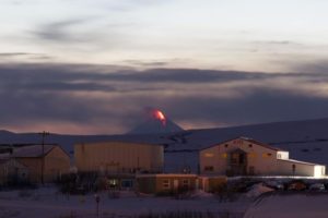
The National Institute of Geophysics and Volcanology (INGV), Oservatorio Etneo, reports that since dusk today, images from monitoring cameras show strong and continuous glows at the Northeast Crater. Intra-crater activity has been ongoing in the same crater for several weeks, but has intensified considerably since December 24. Partial cloud cover is preventing detailed observation of the activity; however, a camera not affiliated with the INGV filmed incandescent material ejected above the crater rim at approximately 6:10 PM UTC.
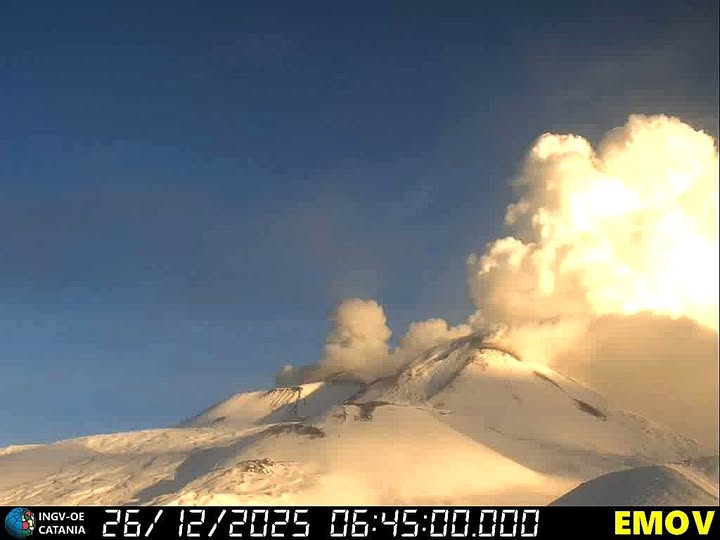
The activity is producing a dense steam plume, without any trace of volcanic ash, which is being pushed by the wind to the east-northeast. From a seismic perspective, the average amplitude of the volcanic tremor is high, reaching a level around 12:00 UTC on December 24th, where it has remained relatively stable. The center of the volcanic tremor sources is located in the Northeast Crater area, at an altitude of 2800 to 2900 m. Infrasound events are occurring very frequently, with increasing amplitudes, and are primarily located in the Northeast Crater and secondarily in Bocca Nuova. The onset of infrasound tremor was observed around 21:50 UTC.
Analysis of data from the ground deformation monitoring network shows a positive variation of approximately 80 nanodeformations on the DRUV dilatometer starting on the morning of December 24th.
Since the morning of December 24th, the ECP inclinometer has recorded a variation greater than 1.5 microradians. The GNSS network shows no significant variation. Further updates will be provided shortly.
Source et photo : INGV.
Mexico , Popocatepetl :
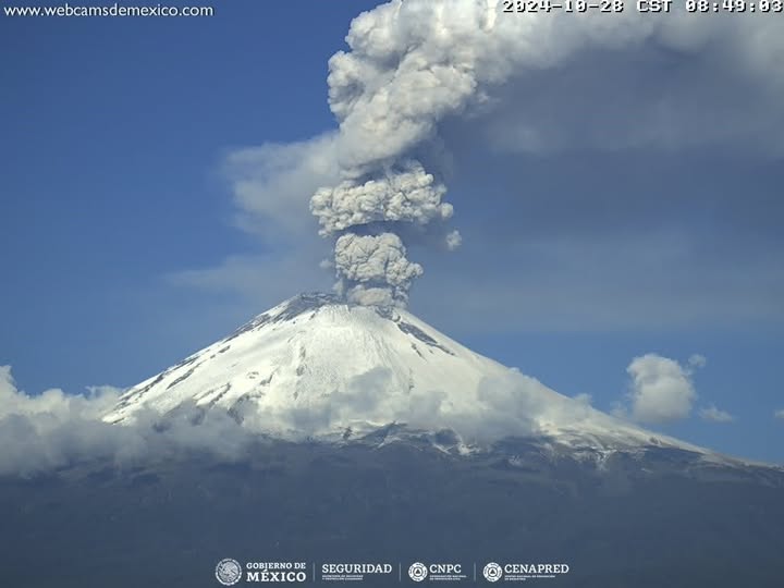
December 25, 11:00 AM (December 25, 5:00 PM GMT), Activity over the past 24 hours
Fifteen low-intensity exhalations were detected, accompanied by water vapor, other volcanic gases, and ash. In addition, 313 minutes of tremor segments were recorded, of which 300 minutes corresponded to high-frequency, low- to medium-amplitude tremor, while the remaining 13 minutes were identified as low-amplitude harmonic tremor.
Visibility is currently reduced due to weather conditions; however, if emissions of water vapor, volcanic gases, and small amounts of ash occur, they are expected to drift primarily to the southeast (SE).
The alert level for Popocatépetl volcano is at yellow (phase 2).
The scenarios considered for this phase are as follows:
Low to medium intensity explosions
Seismic tremors of varying amplitude
Light to moderate ashfall on surrounding towns and some more distant towns
Ejection of incandescent fragments within the 12-kilometer exclusion zone
Lahars (mudflows) could form in ravines due to the accumulation of ash on the slopes and its interaction with the rainfall expected in the coming weeks
Possibility of pyroclastic flows that will not reach inhabited areas.
Source et photo : Cenapred.
Colombia , Puracé / Los Coconucos volcanic chain :
Popayán, December 25, 2025, 9:30 a.m.
Regarding the monitoring of activity in the Los Coconucos volcanic chain, the Colombian Geological Survey (SGC), an agency under the Ministry of Mines and Energy, reports the following:
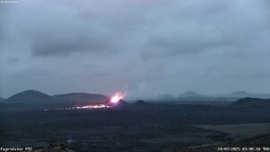
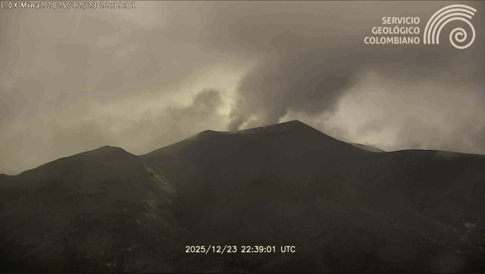
Since the publication of yesterday’s extraordinary bulletin, and continuing to this day, earthquakes related to fluid movements within the volcanic edifice have persisted. These include long-period (LP) earthquakes, seismic pulses (TR), and continuous tremor. This seismicity, located beneath the Puracé volcano crater at a depth of less than 1 km, is linked to the internal dynamics of gases and their release into the atmosphere. Among these seismic signals, four (4) were associated with ash emissions that triggered alerts to the Civil Aviation Authority and dispersed towards the Southeast, reaching an altitude of 600 m above the summit of the volcano.
Furthermore, seismic signals associated with rock fracturing processes continued to be recorded, primarily beneath the Puracé and Piocollo volcanoes, at depths between 1 and 3 km, with a maximum magnitude of 2.2.
Significant emissions of sulfur dioxide (SO₂) into the atmosphere continue to be detected, and temperatures similar to those observed in recent days are still being recorded in the crater area, possibly linked to the emission of hot gases from within the volcano. Constant degassing persists through the fissure on the northern wall of the Curiquinga volcano crater, reported several weeks ago, although no ash emissions have been observed.

Recording from the Mina thermal camera, located 2.2 km north of the Purace volcano. Gas and ash emissions recorded at 7:23 PM on December 24, 2025.
As long as the orange alert level remains in effect, temporary fluctuations in volcanic activity are possible, meaning that it may sometimes decrease compared to previous days or weeks. However, this does not necessarily mean that the volcano has returned to a stable level of activity. A return to the yellow alert level (increased stability) requires a reasonable timeframe to assess all monitored parameters and identify the trends that indicate this.
Consequently, the Colombian Geological Survey (SGC) recommends staying away from the Puracé volcano crater and its surroundings, closely monitoring the situation through special bulletins and information published on our official channels, and following the instructions of local and departmental authorities and the National Unit for Disaster Risk Management (UNGRD).
The volcanic activity level remains at ORANGE alert: Volcano exhibiting significant variations in monitored parameters.
Source et photo : SGC.
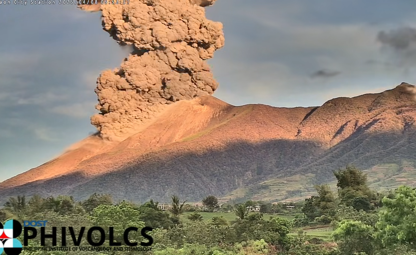
Philippines , Kanlaon :
The Philippine Institute of Volcanology and Seismology (PHIVOLCS) reported continuing eruptive activity at Kanlaon during 16-23 December. The seismic network recorded 1-7 daily volcanic earthquakes. Gas-and-steam emissions of variable densities rose as high as 100 m above the crater rim and drifted NW, W, and SW; weather clouds obscured views on 18 December. Daily sulfur dioxide emissions ranged from 1,787 to 2,763 tonnes per day. Diffuse ash emissions rose 300 m above the summit and drifted NW during 09h01-09h29 and 10h29-11h07. Later that day a period of ash emissions began at 16h05 and persisted for about two hours, sending plumes as high as 900 m above the summit that drifted NW. By the end of the day there had been four periods of ash emissions. The Alert Level remained at 2 (on a scale of 0-5); the public was warned to stay out of the 4-km-radius Permanent Danger Zone (PDZ) and pilots were advised to avoid flying close to the summit.
Kanlaon volcano (also spelled Canlaon) forms the highest point on the Philippine island of Negros. The massive andesitic stratovolcano is covered with fissure-controlled pyroclastic cones and craters, many of which are filled by lakes. The largest debris avalanche known in the Philippines traveled 33 km SW from Kanlaon. The summit contains a 2-km-wide, elongated northern caldera with a crater lake and a smaller but higher active vent, Lugud crater, to the south. Eruptions recorded since 1866 have typically consisted of phreatic explosions of small-to-moderate size that produce minor local ashfall.
Sources: Philippine Institute of Volcanology and Seismology (PHIVOLCS) , GVP.
Photo : Phivolcs ( archive).