December 17 , 2025.
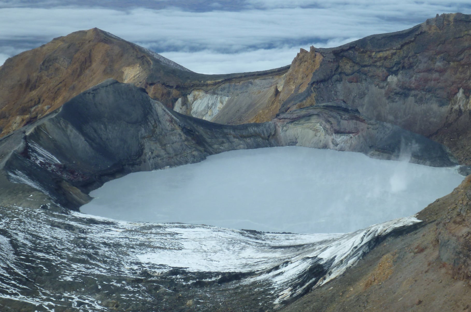
Italy , Stromboli :
WEEKLY BULLETIN, December 8, 2025 to December 14, 2025. Publication date: December 16, 2025
ACTIVITY SUMMARY
Based on monitoring data, the following points should be noted:
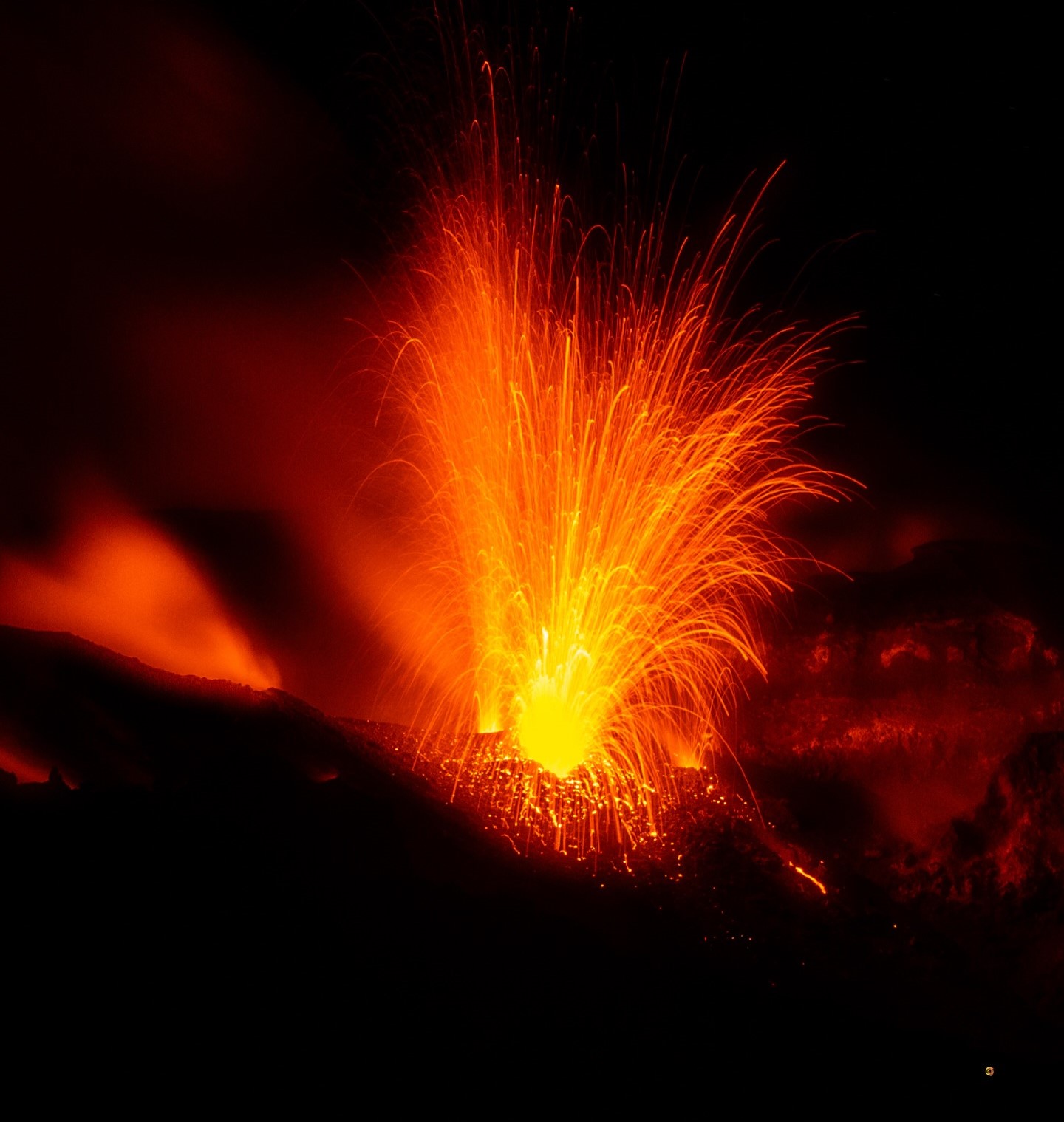
1) VOLCANOLOGICAL OBSERVATIONS: During the reporting period, ordinary Strombolian-type eruptive activity was observed, with ejecta and the formation of a rheomorphic lava flow in the North Crater area. The total hourly frequency fluctuated between average (12 events/h) and high (22 events/h). The intensity of the explosions was mainly low to medium in the North and Central-South Crater areas.
2) SEISMOLOGY: The monitored seismic parameters did not show any significant variations.
3) GROUND DEFORMATION: Ground deformation monitoring networks have not shown any significant variations over the past week.
4) GEOCCHEMISTRY: Average SO₂ flux.
High CO₂ flux from the soil in the Pizzo area (STR02) (approximately 13,000 g/m²/day).
C/S ratio in the pen: Average C/S ratio.
Dissolved helium isotope ratio (R/Ra) in the thermal aquifer: Data not updated. The latest available data (November 5, 2025) indicates very high values.
High CO₂ flux from the soil in the San Bartolo area.
Stable CO₂ flux from the soil in the Scari area (approximately 150 g/m²/day).
5) SATELLITE OBSERVATIONS: The thermal activity observed by satellite in the summit area was generally weak, with a few isolated thermal anomalies of moderate intensity.
VOLCANOLOGICAL OBSERVATIONS
During the observation period, Stromboli’s eruptive activity was characterized by analyzing images recorded by the INGV-OE monitoring cameras located at 190 m (SCT-SCV) and at Punta dei Corvi (SPCT). Explosive activity was primarily produced by five eruptive vents located in the northern zone of the crater and by at least two vents located in the central-southern zone. Due to heavy cloud cover on December 11, the crater terrace was not visible for a sufficient number of hours for a precise description of the eruptive activity.
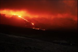
On December 14, a rheomorphic lava flow was observed escaping from the northern zone of the crater.
Observations of explosive activity captured by surveillance cameras
In the North (N) zone of the crater, five active vents were observed: two in sector N1 and three in sector N2. These ejections produced explosive activity of low (less than 80 m high) and medium intensity (less than 150 m high) intensity. The eruptive products were mainly composed of coarse material (bombs and lapilli). In addition, intense and prolonged ejection activity was observed in sector N2. The average frequency of explosions varied between 10 and 21 events per hour.
In the Central-South (CS) crater zone, two main vents were observed, exhibiting explosions of fine material mixed with fine material and of coarse material of low to medium intensity, respectively. The average frequency of explosions varied from 0 to 3 events per hour.
Rheomorphic flow on December 14, 2025
Late in the morning of December 14, intense ejection activity began at the southern vent of sector N2. This produced a significant accumulation of pyroclastic material that extended over several hundred meters in the upper part of the Sciara del Fuoco, forming a rheomorphic flow that was visible for several hours.
Source : INGV.
Photo : Stromboli stati d’animo / Sebastiano Cannavo .
New Zealand , Ruapehu :
Te Wai ā-moe (Ruapehu Crater Lake) is warming up. The Volcanic Alert Level remains at 1 Published: Wed Dec 17 2025 10:00 AM
The temperature of Te Wai ā-moe (Ruapehu Crater Lake) is slowly rising again. The current temperature is now 17 – 18 °C, from a low of 12 °C in early November. We continue to measure low to moderate volcanic sulphur dioxide (SO2) gas emissions, and low levels of volcanic tremor. The Volcanic Alert Level remains at 1 and the Aviation Colour Code at Green.
Earlier this year, Te Wai ā-moe was in a cooling phase from late August to mid-October with the lake temperature dropping from about 17 °C to a low of about 12 °C. During that cooling, the amount of sulphur dioxide (SO2) gas coming out through the lake decreased, consistent with the cooling of the hydrothermal system beneath the lake.
There are now clear indications the lake is reheating, with an increase in temperature of about 5 °C since early November; this is a similar heating rate to that observed in July to September of this year. The daily average is currently around 17 – 18 °C. Both the increase and the current temperature are well within the expected norms.
The amount of sulphur dioxide (SO2) gas has remained low to moderate during the ongoing heating episode. Minor upwellings of hot water and yellow sulphur slicks were observed on the lake surface during a recent gas flight; the slicks are usually related to hot fluids entering the lake floor and melting sulphur. The amount of gas passing through the lake is within the normal range and volcanic tremor remains low.
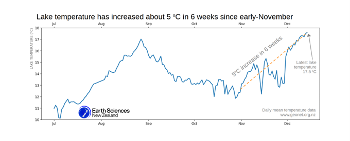
Te Wai ā-moe (Ruapehu Crater Lake) has recently changed from cooling to heating. Daily mean temperature collected by a monitoring station at the lake
These observations are consistent with ongoing, low-level volcanic activity at Ruapehu consistent with minor volcanic unrest. Therefore, the Volcanic Alert Level remains at 1 and the Aviation Colour Code remains Green.
Source : Geonet /Oliver Lamb / Duty Volcanologist
Photos : Geonet.
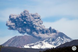
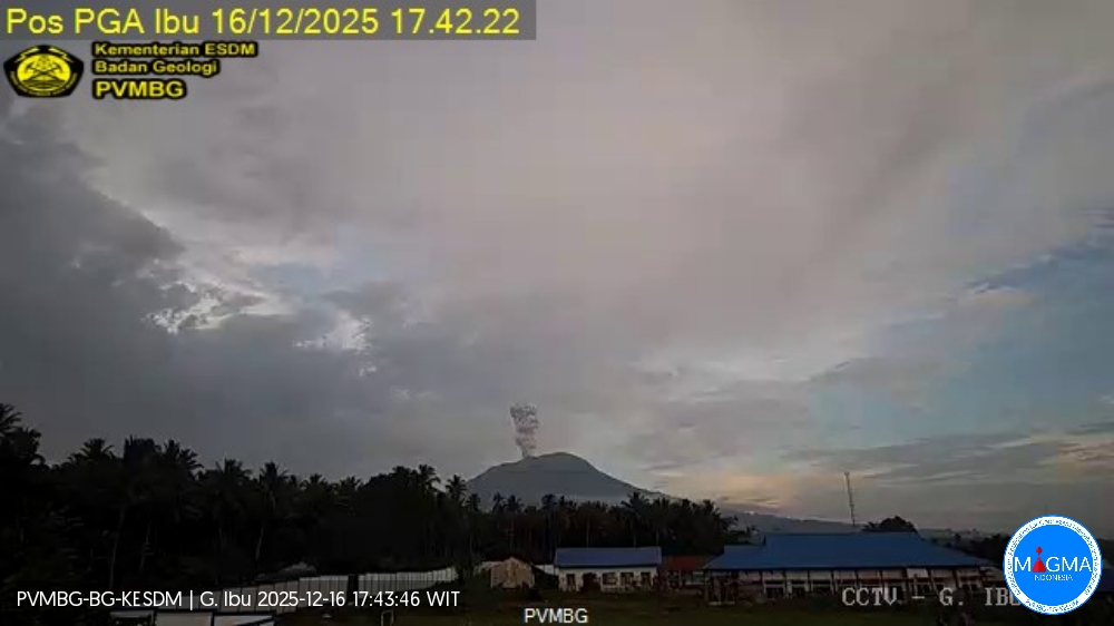
Indonesia , Ibu :
Mount Ibu experienced an eruption on Tuesday, December 16, 2025 at 17:41 (West Africa local time). An ash column was observed approximately 700 meters above the summit (at an altitude of about 2,025 meters). This column was white to gray in color, moderate to strong in intensity, and directed northeast. At the time of writing, the eruption was still ongoing.
Seismic Observations
100 eruption earthquakes with amplitudes of 12 to 28 mm and durations of 30 to 100 seconds.
3 emission earthquakes with amplitudes of 2 to 10 mm and durations of 33 to 43 seconds.
18 harmonic tremors with amplitudes of 2 to 15 mm and durations of 27 to 123 seconds.
152 low-frequency earthquakes with amplitudes of 2 to 10 mm and durations of 17 to 29 seconds.
188 shallow volcanic earthquakes with amplitudes of 2 to 6 mm and durations of 7 to 21 seconds.
1 deep volcanic earthquake with an amplitude of 2 mm and a duration of 23 seconds.
Two local tectonic earthquakes with magnitudes of 2 to 4 mm and durations of 37 seconds.
Twenty distant tectonic earthquakes with magnitudes of 2 to 28 mm and durations of 33 to 122 seconds.
Recommendations
1. Residents living around Mount Ibu and visitors/tourists are advised to refrain from all activities within a 2 km radius and a 3.5 km sector around the crater opening in the northern part of the active Mount Ibu crater.
2. In case of ashfall, people engaging in outdoor activities are advised to wear a mask covering their nose, mouth, and eyes, as well as protective eyewear.
Source et photo : PVMBG.
Colombia , Puracé – Los Coconucos volcanic chain :
Popayán, December 16, 2025, 9:00 AM
Regarding the monitoring of activity in the Los Coconucos volcanic chain, the Geological Survey of Colombia (SGC), an agency under the Ministry of Mines and Energy, reports the following:
Since the publication of yesterday’s extraordinary bulletin, and continuing to this day, earthquakes related to fluid movements within the volcanic edifice have persisted. These include long-period (LP) earthquakes, tremor pulses (TR), and continuous tremor. This seismicity has been localized primarily beneath the Puracé volcano crater, at a depth of less than 1 km, and is linked to the internal dynamics of gases and their emission into the atmosphere. In addition, low-magnitude seismic signals associated with rock fracturing have been recorded. These signals were mainly located within a radius of less than 1 km around the crater of the Purace volcano, at depths of less than 3 km.
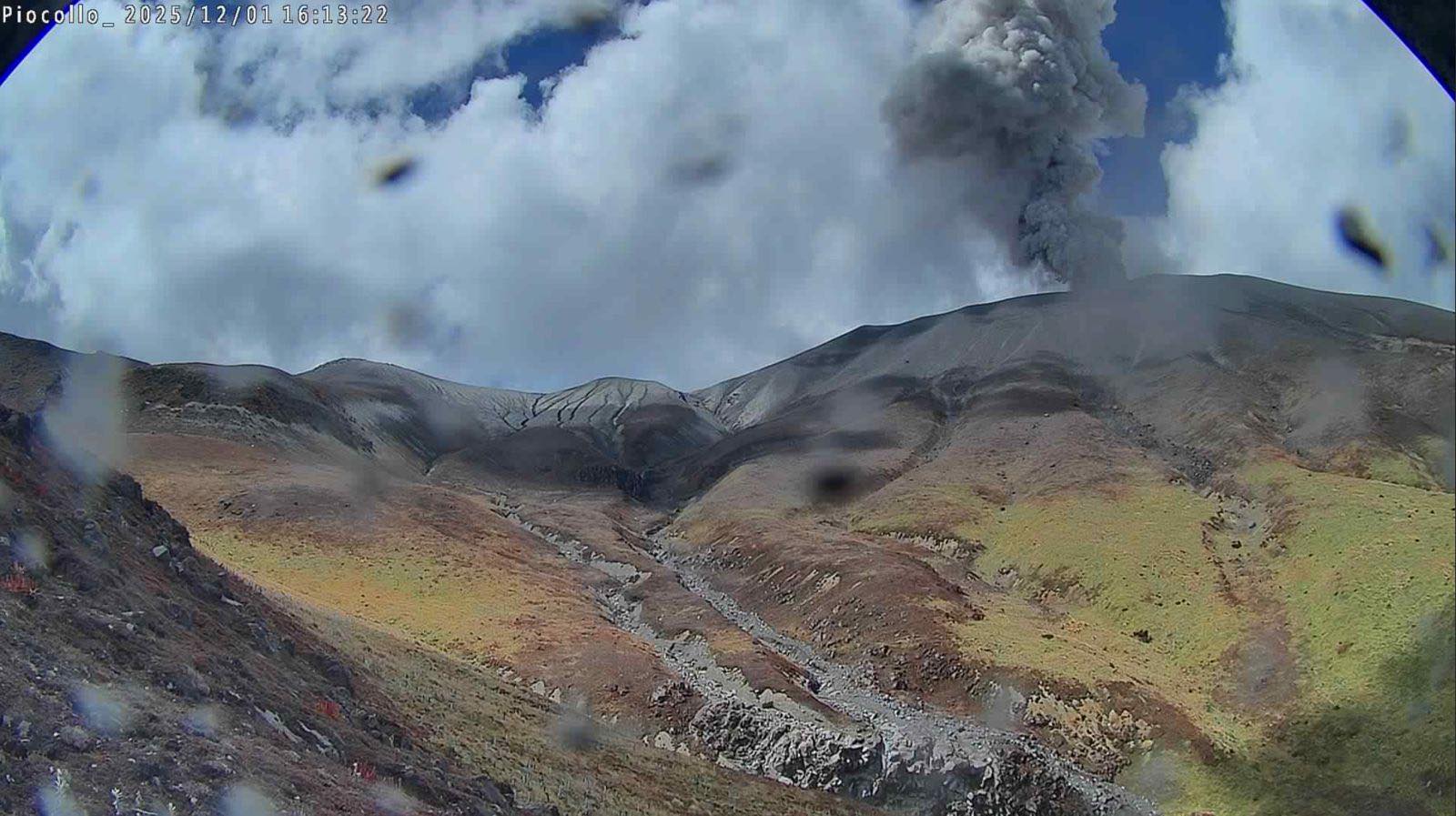
Some of these signals were linked to ash emissions, dispersed mainly to the northwest, following the wind direction, and reaching an altitude of 700 m above the volcano’s summit. Two ash emissions were recorded and alerted the Civil Aviation Authority. Significant levels of sulfur dioxide (SO₂) emissions into the atmosphere continue to be detected by satellite. These emissions are dispersing primarily westward within a 300 km radius of the volcano. Similarly, temperatures comparable to those observed in recent days are still being recorded in the crater area, possibly linked to the emission of hot gases from within the volcano.
As long as the orange alert remains in place, temporary fluctuations in volcanic activity are possible; it may therefore sometimes decrease compared to previous days or weeks. However, this does not necessarily mean that the volcano has returned to a stable level of activity. For a return to the yellow alert level (increased stability), a reasonable time is needed to assess all monitored parameters and determine any trend indicating such a return.
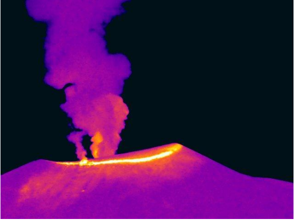
Thermal imaging camera image from Mina, located 2.2 km north of the Puracé volcano. Gas and ash plume recorded at 3:21 a.m. on December 16, 2025.
Given the above, the Geological Survey of Colombia (SGC) recommends staying away from the volcano’s crater and surrounding areas, closely monitoring the situation through special bulletins and information published on our official channels, and following the instructions of local and regional authorities and the National Unit for Disaster Risk Management (UNGRD).
The volcanic activity level remains at ORANGE alert: Volcano with significant changes in monitored parameters.
Source et photos : SGC.
Costa Rica , Poas / Rincon de la Vieja :
Volcano: Poás
Latitude: 10.200
Longitude: -84.233
Altitude: 2,687 m
Observed Activity: A slight background tremor persists between 0.8 and 5 Hz. No eruptions or significant changes in surface activity have been detected in the last 24 hours. Geodetic stations indicate slight crater expansion.
Environmental Conditions:
Southwest winds. Persistent heavy cloud cover over the volcano.
Activity Level: Alert (2)

Volcano: Rincón de la Vieja
Latitude: 10.83
Longitude: -85.324
Altitude: 1,916 m
Observed Activity:
The seismic signal indicates very weak tremor, with dominant frequencies between 1 and 3 Hz. Geodetic stations show no significant deformation, except for subsidence at the summit of the volcanic edifice.
Environmental Conditions:
Southwest wind. Persistent heavy cloud cover over the volcano.
Activity Level: Alert (2)
Source : Ovsicori .
Photo : Rincon / E. Duarte / Ovsicori.