November 28 , 2025.
Hawaii , Kilauea :
HVO/USGS Volcanic Activity Notice
Current Volcano Alert Level: WATCH
Current Aviation Color Code: ORANGE
Issued: Wednesday, November 26, 2025, 12:25 AM HST
Source: Hawaiian Volcano Observatory
Notice Number: 2025/H513
Location: N 19 deg 25 min W 155 deg 17 min
Elevation: 4091 ft (1247 m)
Area: Hawaii
Volcanic Activity Summary:
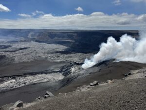
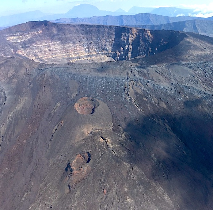
Episode 37 of the ongoing Halemaʻumaʻu eruption ended abruptly at 11:39 p.m. HST on November 25 after 9.2 hours of continuous fountaining.
The north vent stopped erupting at approximately 11:39 p.m. HST marking the end of episode 37. No lava fountains or flows erupted from the south vent during episode 37. Dual lava fountains from the north vent reached maximum heights of 500-600 ft (150-180 m). Continuous fountaining lasted for 9.2 hours and produced an estimated 8.2 million cubic yards (6.3 million cubic meters) of lava. The combined average eruption rate was over 200 cubic yards per second (190 cubic meters per second). Lava flows from the fountains covered about 75% of the floor of Halemaʻumaʻu crater.
The eruptive plume reached heights of more than 14,000 ft (4,200 m) above sea level during episode 37. Volcanic gas emissions greatly decreased after lava fountaining ended.
The Uēkahuna tiltmeter (UWD) recorded about 16.5 microradians of deflationary tilt during episode 37. The end of lava fountaining was coincident with a rapid change from deflation to inflation at the summit and a decrease in seismic tremor intensity.
Lava flows from this episode on the floor of Halemaʻumaʻu within the southern part of Kaluapele (Kīlauea caldera) may continue to exhibit slow movement or incandescence as they cool and solidify over the coming days.
No changes have been detected in the East Rift Zone or Southwest Rift Zone.
Source : HVO
Photo : USGS / M. Patrick.
La Réunion , Piton de la Fournaise :
Press Release from the Paris Institute of Earth Physics, Piton de la Fournaise Volcanological Observatory
November 27, 2025 – 5:00 PM local time – 2:00 PM UTC
Since mid-September 2025, a slight increase in seismicity has been observed beneath the Plaines region (see monthly bulletins from the OVPF-IPGP). This activity, located at a depth of approximately 20 km, suggests a reactivation of the deep transfer zone, potentially linked to deep magma movements or increased pressurization in the internal conduits of Piton de la Fournaise.
In this context, since November 22, 2025, a moderate increase in seismicity beneath the summit area of the volcano has also been recorded (Figure 1). This sequence was initially marked by deep seismicity beneath the northern rim of the Dolomieu crater (4–5 km depth). These earthquakes are of very low magnitude (M<0.4), and the current increase remains limited, well below what was observed in this area during the deep reactivations of 1998 and 2015.
From November 24th, this deep activity was accompanied by the occurrence of several long-period (LP) events, followed, from November 26th, by a slight increase in shallower seismicity, around 2 km below the summit, above the shallow magma reservoir, with 16 events recorded that day.
At this stage, this moderate increase in seismicity, combined with the absence of significant ground deformation and the lack of any notable change in CO₂ emissions (despite a slight increase in CO₂ at one of our stations since September), does not suggest a major replenishment of the shallow magma reservoir.
The OVPF team remains vigilant and continues to monitor the activity of Piton de la Fournaise to detect any significant changes in the situation.
Source et photo : direction de l’OVPF-IPGP.
Kamchatka , Sheveluch :
VOLCANO OBSERVATORY NOTICE FOR AVIATION (VONA)
Issued: November 28 , 2025
Volcano: Sheveluch (CAVW #300270)
Current aviation colour code: ORANGE
Previous aviation colour code: orange
Source: KVERT
Notice Number: 2025-150
Volcano Location: N 56 deg 38 min E 161 deg 18 min
Area: Kamchatka, Russia
Summit Elevation: 3283 m (10768.24 ft), the dome elevation ~2500 m (8200 ft)
Volcanic Activity Summary:
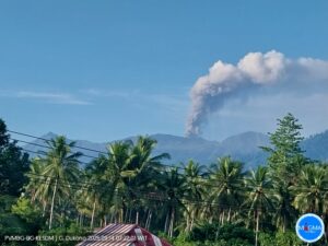
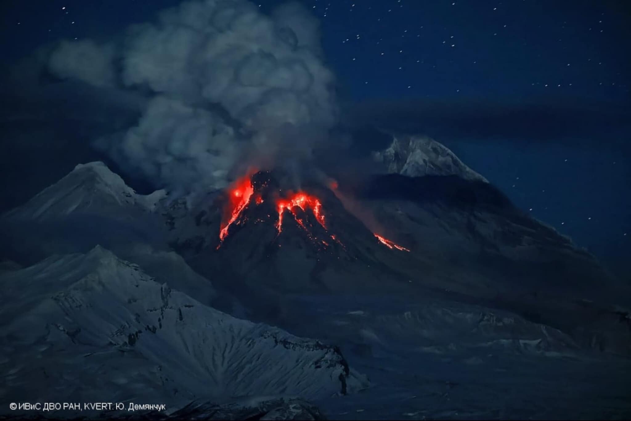
The explosive-extrusive eruption of the volcano continues. Explosions sent ash up to 5-5.4 km a.s.l., and ash plume extended for 40 km to the east-southeast of the volcano.
The explosive-extrusive eruption of the volcano continues. The danger of ash explosions up to 10 km (32,800 ft) a.s.l. remains. Ongoing activity could affect international and low-flying aircraft.
Volcanic cloud height:
5000-5400 m (16400-17712 ft) AMSL Time and method of ash plume/cloud height determination: 20251128/0500Z – Himawari-9 14m15
Other volcanic cloud information: Distance of ash plume/cloud of the volcano: 40 km (25 mi)
Direction of drift of ash plume/cloud of the volcano: ESE / azimuth 123 deg
Time and method of ash plume/cloud determination: 20251128/0540Z – Himawari-9 14m15
Start time of explosion and how determined: 20251128/0410Z – Satellite data
Source : Kvert.
Photo : Yu. Demyanchuck / IVS FEB RAS KVERT via Olga Girina. ( archive 2023)
Colombia , Puracé – Los Coconucos volcanic chain :
Popayán, November 27, 2025, 10:45 PM
Regarding the monitoring of activity in the Los Coconucos volcanic chain, the Geological Survey of Colombia (SGC), an agency under the Ministry of Mines and Energy, reports the following:
Today, November 27, 2025, the SGC received reports of ashfall from several localities in the municipality of Puracé, located northwest of the volcano, including rural areas such as Cristales, Anambío, Alto Michabala, and Chapío, as well as from the municipal capital of Coconuco, located west of the volcano. This ashfall is due to gas and ash emissions from the Puracé volcano, which continues to exhibit seismic activity related to fluid dynamics at shallow depths beneath its crater.
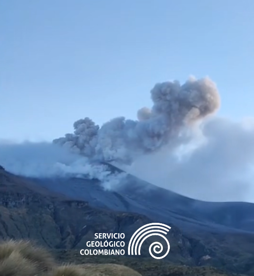
It is important to emphasize that these emissions could continue, as predicted by the yellow alert, and that their dispersion will depend on wind patterns. In this alert context, incandescence, small explosions within the crater, low-energy thermal anomalies, noise, felt seismic tremors, odors, sulfur precipitation near the crater and in hot springs and fumaroles, degassing outside the crater, the formation of fissures, and minor lahars may also occur.
Given the above, the Geological Survey of Colombia (SGC) advises against accessing the volcano and recommends closely monitoring the evolving situation through special bulletins and other information published via its official channels, as well as following instructions from local and departmental authorities and the National Unit for Disaster Risk Management (UNGRD).
Volcanic activity remains on yellow alert: Active volcano with changes in baseline level behavior of monitored parameters and other manifestations.
Source et photo : SGC.
Indonesia , Semeru :
The Pusat Vulkanologi dan Mitigasi Bencana Geologi (PVMBG) reported that eruptive activity continued at Semeru during 20-25 November. Eruptive events were recorded during 20-21 and 24 November, but weather conditions prevented visual confirmation. White-and-gray ash plumes rose 500-700 m above the summit and drifted SW on 23 November and rose 500-1,000 m and drifted N on 25 November. Incandescence at the summit on the upper SE flank was visible in several nighttime webcam images.
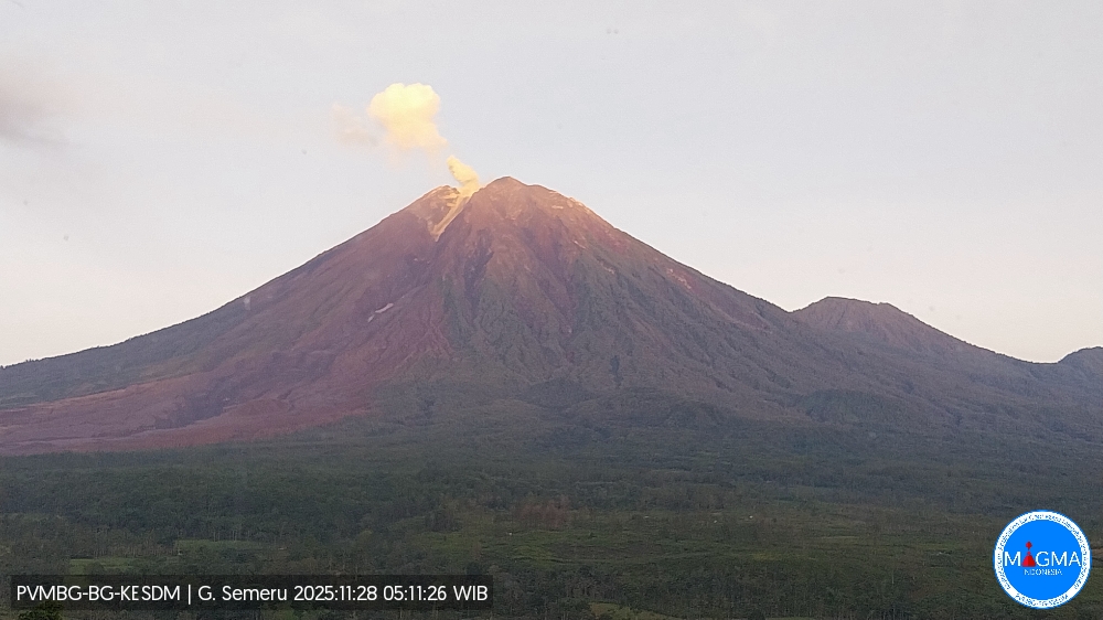
Around 300 residents were evacuated on 19 November after a series of pyroclastic density currents (PDCs) traveled as far as 13 km down the S and SE flanks. Authorities also evacuated 137 climbers who were camping within 8 km of the summit in the Ranu Kumbolo area. By the evening of 20 November there were 1,116 people in evacuation shelters. There were no fatalities, though three people were significantly burned. Rain continued in the area during 19-21 November. On the evening of 21 November lahars interacted with hot material that had been deposited along the Regoyo River, causing a burst of ash and steam that deposited material on the Piket Zero road, which connects Lumajang (32 km ESE) and Malang (35 km NW). Authorities temporarily closed access to the Besuk Kobokan Bridge (13 km SE) or Gladak Perak Bridge due to low visibility. The Badan Nacional Penanggulangan Bencana (BNPB) reported that drone surveys were carried out on 23 November to assess the areas impacted by ashfall, focusing on Sumbermujur (9 km ESE) and the Besuk Kobokan Bridge. They found that ashfall impacted Supiturang (8 km SE) and Oro-Oro Ombo (8 km SE) in the Pronojiwo District, and Penanggal Village (14 km ESE) in the Candipuro District. There were 21 severely damaged houses, damage to an education facility, and damage to a health facility. Additionally, about 204 hectares of agricultural land were impacted. The Alert level remained at 4 (the highest level on a scale of 1-4) and the public was warned to stay at least 8 km away from the summit in all directions and 500 m from the banks of the Kobokan drainage as far as 20 km from the summit.
Sources: Pusat Vulkanologi dan Mitigasi Bencana Geologi (PVMBG, also known as CVGHM), Badan Nacional Penanggulangan Bencana (BNPB), Antara News, Antara News, Antara News, Antara News , GVP.
Photo : Magma Indonésie .