November 18 , 2025.
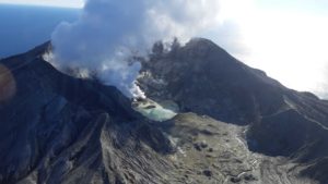
Italy , Stromboli :
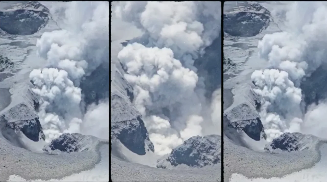
November 17, 2025 08:38 (07:38 UTC), Statement on Stromboli Activity:
The National Institute of Geophysics and Volcanology, Etna Observatory, reports that analysis of surveillance camera images has revealed, since approximately 07:00 UTC,
a lava flow originating from the North Crater, feeding a lava flow in the upper part of the Sciara del Fuoco. This flow is accompanied by continuous ejections from at least two vents in the North Crater.
Explosive activity continues in the South Crater.
From a seismic perspective, volcanic tremor shows no significant variations, fluctuating within the average range. No explosions of particular amplitude have been observed, and the frequency of occurrence has remained unchanged over the past few hours.
Data from ground deformation monitoring networks show no significant changes.

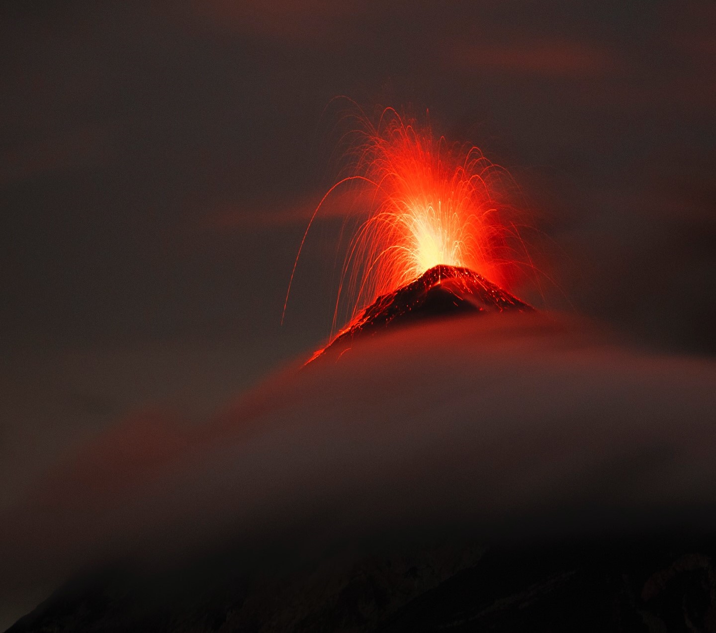
November 17, 2025, 6:50 PM (5:50 PM UTC)
The National Institute of Geophysics and Volcanology, Etna Observatory, reports that surveillance camera images show the lava flow from the North Crater area, mentioned in this morning’s statement, has ceased and is cooling. Explosive activity and lava eruptions continue in the North Crater area, at varying intensities, with lava flows in the upper part of the Sciara del Fuoco.
From a seismic perspective, the average amplitude of volcanic tremors is currently at its average level. No significant changes have been observed in the frequency and amplitude of explosion earthquakes.
Data from ground deformation monitoring networks show no significant changes.
Further information will be released soon.
Source : INGV
Photo : Stromboli stati d’animo / Sebastiano Cannavo
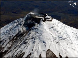
Indonesia , Semeru :
Mount Semeru erupted on Tuesday, November 18, 2025, at 06:11 WIB. An ash column was observed approximately 800 meters above the summit (at an altitude of about 4,476 meters). This ash column, white to gray in color, was highly intense and extended southward. The eruption was recorded by a seismograph with a maximum amplitude of 22 mm and a duration of 112 seconds.
VOLCANO OBSERVATORY NOTICE FOR AVIATION – VONA
Issued : November 17 , 20251117/2311Z
Volcano : Semeru (263300)
Current Aviation Colour Code : ORANGE
Previous Aviation Colour Code : orange
Source : Semeru Volcano Observatory
Notice Number : 2025SMR3304
Volcano Location : S 08 deg 06 min 29 sec E 112 deg 55 min 12 sec
Area : East java, Indonesia
Summit Elevation : 11763 FT (3676 M)
Volcanic Activity Summary :
Eruption with volcanic ash cloud at 23h11 UTC (06h11 local).
Volcanic Cloud Height :
Best estimate of ash-cloud top is around 14323 FT (4476 M) above sea level or 2560 FT (800 M) above summit. May be higher than what can be observed clearly. Source of height data: ground observer.
Other Volcanic Cloud Information :
Ash cloud moving to south. Volcanic ash is observed to be white to gray. The intensity of volcanic ash is observed to be thick.
Remarks :
Eruption recorded on seismogram with maximum amplitude 22 mm and maximum duration 112 second.
Source : PVMBG.
Photo : Andi Volcanist.( archive)
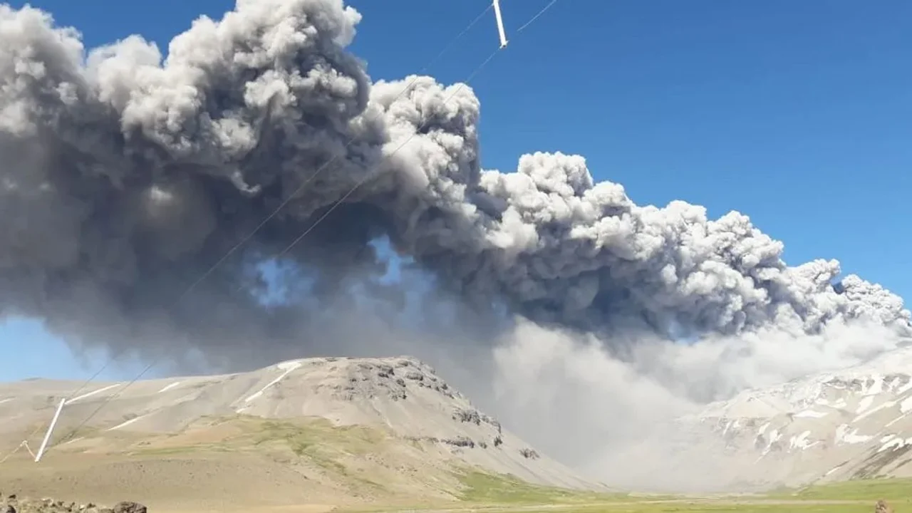
Chile / Argentina , Planchón Peteroa :
The Argentine Geological and Mining Service (SEGEMAR), through its Argentine Volcanological Observatory (OAVV), reports that since Monday, November 17, 2025, at 10:10 PM local time (1:10 AM UTC on November 18), volcanic monitoring stations located near the Planchón Peteroa volcanic complex have recorded an increase in the frequency of volcano-tectonic earthquakes associated with rock fracturing within the volcanic system. A total of thirty-six (36) low-magnitude events were recorded over a two-hour period.
High-Energy Event Information
Origin Time: 10:10 PM local time (1:10 AM UTC on November 18)
Latitude: -35.282°
Longitude: -70.468°
Depth: 9.2 km
Local Magnitude: 2.3 (ML)
OBSERVATIONS:
At the time of writing, low-energy volcano-tectonic (VT) activity continues in the same area. It should be noted that no abnormal surface activity related to this event has been observed. Nighttime incandescence persists, as in previous days.
CONCLUSIONS
The technical alert level remains in effect and monitoring of the volcano will continue in constant communication with the Southern Andes Volcanological Observatory (OVDAS) of Chile, as well as with local, provincial and national civil protection authorities, within the framework of the National Integrated Risk Management System (SINAGIR) through the Federal Emergency Situations Agency (AFE).
The recent reactivation of the Planchón-Peteroa volcano, located on the border between Argentina and Chile, has once again sparked concern in southern Mendoza. In recent days, authorities have detected an ash plume affecting areas such as Bardas Blancas and rural areas of Malargüe, accompanied by a sulfurous odor and significantly reduced visibility.
The event was recorded by satellite imagery from the National Meteorological Service and confirmed by the Civil Protection Directorate of Malargüe, as well as by the Argentine Volcanological Observatory (SEGEMAR). According to technical reports, the ash column reached a height of approximately 800 meters, driven by winds from Chile.
Source : Segemar , canal 13 san juan .
Photos : canal 13 san juan
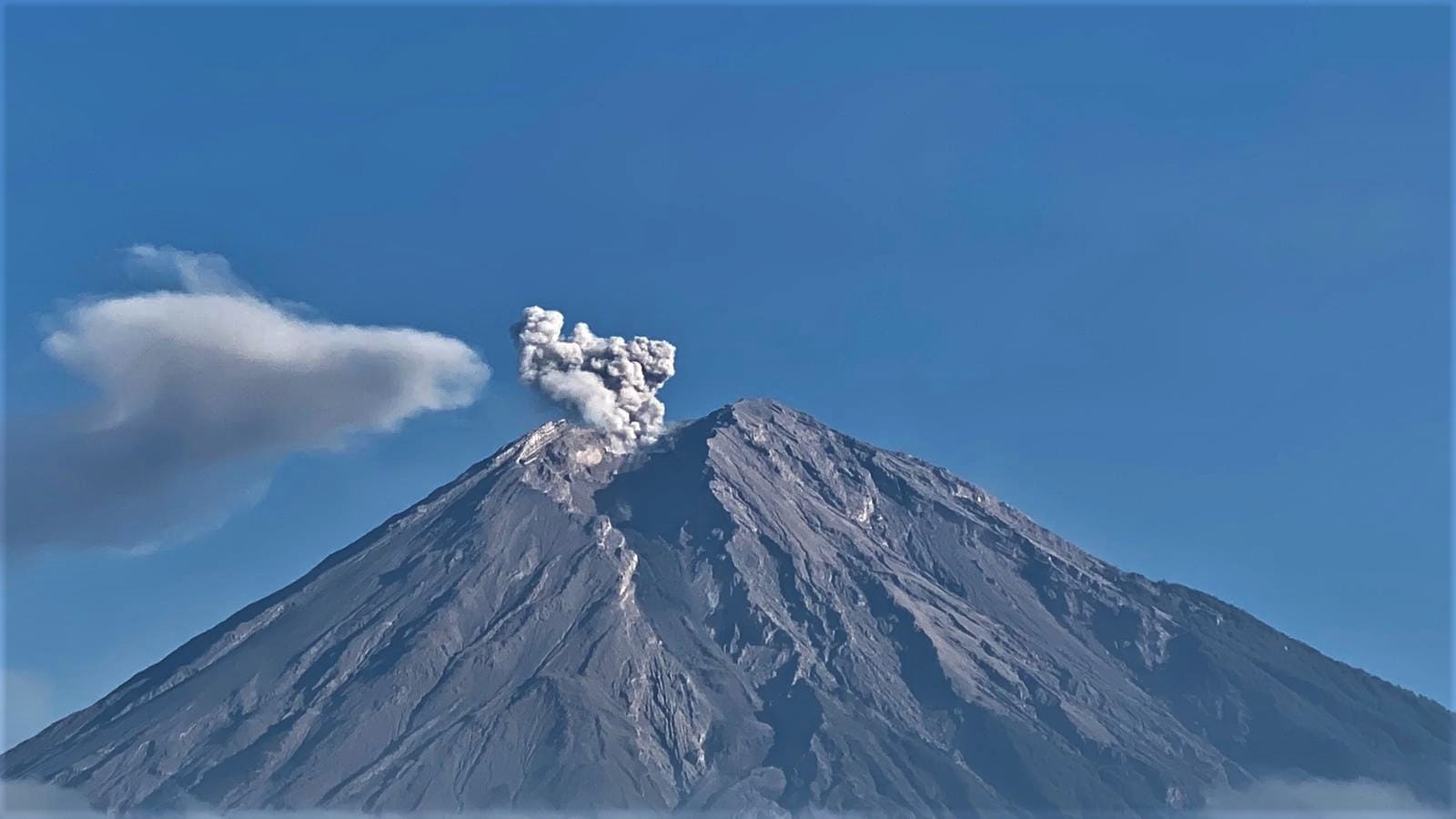
Guatemala , Fuego :
Atmospheric conditions: Clear skies
Wind: East
Rainfall: 38.0 mm
Activity
During the night and early morning, weak to moderate degassing was recorded, with fumaroles reaching approximately 200 meters above the crater and dispersing westward.
Explosive activity continued with 7 to 11 weak to moderate explosions per hour, generating ash plumes rising to between 4,200 and 4,600 meters in altitude, drifting 10 to 12 km to the west and southwest. This activity caused fine ash to fall on Panimache I and nearby localities.
Some explosions generated rumbling sounds, shockwaves, and noises similar to those of locomotives, lasting up to a minute, associated with the continuous expulsion of gas. Incandescent glows were also observed rising up to 200 meters above the crater, accompanied by small avalanches.
Incandescent material was also observed falling back around the crater, flowing towards the ravines of Ceniza, Taniluyá, Seca, Santa Teresa, Trinidad, and Las Lajas, sometimes reaching the tree line.
Source : Insivumeh.
Photo : Diego Rizzo / FB.
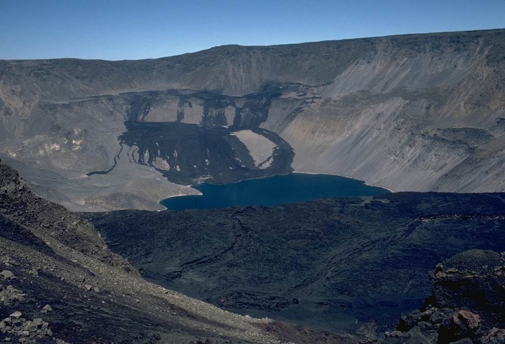
Galapagos Islands , Fernandina :
The Geophysical Institute is continuously monitoring Fernandina Island in the Galápagos archipelago due to a possible new eruption. The alert was issued on Monday, November 17, following the recording of a series of seismic tremors.
According to the Geophysical Institute’s report, an earthquake measuring 4.3 on the Richter scale was recorded at approximately 12:06 a.m. In addition, a series of less intense tremors began at 9:00 a.m. on the island’s north coast.
Eight earthquakes were recorded on Monday between 9:06 a.m. and 4:24 p.m. Their magnitudes ranged from 2.6 to 3.3, and their epicenters were all located near Puerto Villamil in the Galápagos.
“This sequence of seismic activity is characteristic of pre-eruptive processes on Fernandina Island. Therefore, there is a high probability that the volcano will begin a new eruption,” the geophysicist warned.
He also specified that there are no inhabited areas on Fernandina Island, thus ruling out any risk to the population.
“The Geophysical Institute continues to monitor the phenomenon and will issue an alert in the event of significant changes,” he added.
This alert comes 18 months after the eruption of the La Cumbre volcano, which began its activity on March 2, 2024, with lava flows reaching the ocean.
Photo : Lee Siebert, 1978 (Smithsonian Institution).