November 12 , 2025.
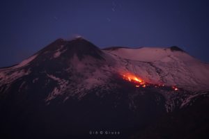
Iceland , Reykjanes Peninsula :
Unchanged Hazard Assessment for the Reykjanes Peninsula .Updated 11 November 2025
Key Points
Deformation beneath Svartsengi continues, although at a slower pace than before.
There is still uncertainty regarding the timing of the next event.
The hazard assessment has been updated and remains unchanged until November 25, unless changes occur.
Seismic activity in Krýsuvík has significantly decreased in recent weeks.
Deformation Measurements
Deformation measurements indicate ongoing uplift and magma accumulation beneath Svartsengi, although the rate of magma inflow is gradually decreasing.
Based on previous events on the Sundhnúkur crater row, the likelihood of a new magma intrusion and eruption increases when a comparable amount of magma has accumulated beneath Svartsengi as before the last eruption. The amount of magma that has drained from Svartsengi during eruptive episodes since March 2024 has varied, ranging from 12–31 million cubic meters. According to model calculations, about 15 million cubic meters of magma have now accumulated beneath Svartsengi since the last eruption in July. Therefore, there is still considerable uncertainty about when the next event will occur.
As inflow decreases, the timeframe for a possible next event has lengthened. The accompanying graph shows that the lower volume threshold was reached in early October, while the upper threshold is projected to be reached in early February, assuming inflow remains unchanged. The upper threshold is set at 23 million cubic meters of magma, which is the average amount that has drained from Svartsengi during the last five eruptions.
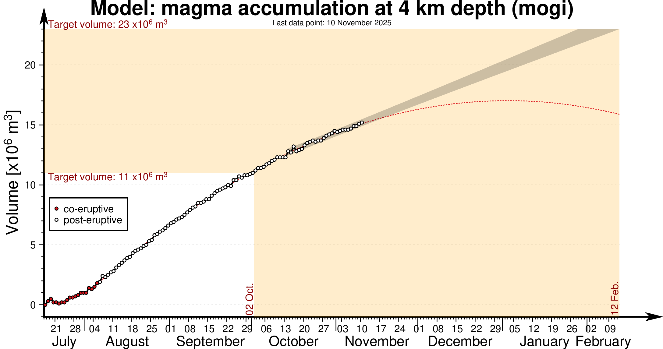
Model of magma accumulation at 4 km depth beneath Svartsengi since 17th July. The black circles show daily measurements of magma volume from July 2025 to the present day. The shaded area represents a forecast of magma accumulation at a constant inflow rate, while the red dashed line indicates a likely trend if the inflow rate continues to decrease. The volume thresholds of 11 and 23 million cubic meters are estimated model bounds for a potential magma intrusion and eruption.
Seismic Activity
Earthquakes near Grindavík and along the Sundhnúkur crater row are few and small; most days only a handful of microearthquakes are detected, around or just above magnitude M1.
Activity near Krýsuvík
Deformation measurements show that the subsidence that began in Krýsuvík this summer has slowed significantly, and deformation is now minimal in the area. Earthquakes in Krýsuvík still occur a few times per day, but activity has decreased substantially. The total number of earthquakes has dropped from 250 down to 100–150 per week. This is the first time since summer that the earthquake pattern shows a continuous decline.
Source : IMO
Photos : IMO.
Colombia , Chiles / Cerro Negro :
San Juan de Pasto, November 11, 2025, 3:10 PM
Regarding the monitoring of activity at the Chiles-Cerro Negro Volcanic Complex (CVCCN), the Colombian Geological Survey (SGC), an agency under the Ministry of Mines and Energy, reports the following:
During the period from November 4 to 10, 2025, the main variations in monitored parameters compared to the previous week were as follows:
• A significant decrease in the number of earthquakes was observed. However, the seismic energy released increased, as 15 earthquakes with a magnitude greater than 2.0 were recorded during this period. Among these, two earthquakes of magnitudes 3.7 and 3.2 occurred on November 9, but were not felt.
• Seismicity associated with rock fracturing processes within the volcanic edifice remained predominant. The earthquakes were mainly located near the summit of Chiles volcano, in several sectors and within a 2 km radius south, southwest, and west of its summit. As indicated in previous bulletins, this seismicity was concentrated at depths between 2 and 6 km below the summit (reference level above 4,700 m altitude).

• Analysis of data from satellite sensors, GNSS stations, and tiltmeters continues to show variations in the volcanic zone, most likely linked to changes in recorded seismic activity.
Based on the assessment and correlation of monitored parameters, the Geological Survey of Colombia (SGC) recommends closely monitoring their evolution through weekly bulletins and other information published via its official channels, as well as following instructions from local and departmental authorities and the National Unit for Disaster Risk Management (UNGRD).
Volcanic activity remains at the yellow alert level: active volcano with changes in the baseline behavior of monitored parameters and other manifestations.
Source et photo : SGC
Costa Rica , Rincon de la Vieja :
Latitude: 10.83°N
Longitude: 85.34°W
Altitude: 1916 m
Current Activity Level: Alert
Five small eruptions and two exhalations were recorded this week. The largest occurred on Sunday at 11:46 a.m. None resulted in lahars. Background tremor varied in amplitude and frequency this week and remained generally low compared to previous months. It remained low on November 4 and 5, but its amplitude increased slightly after the eruption on November 6. Brief tremor pulses were also observed throughout the week, with variations in amplitude, frequency, and duration.
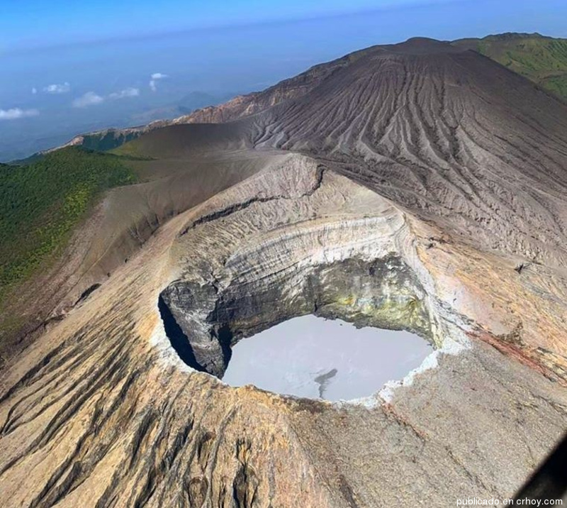
Long-period and tornillo-type earthquakes continued to occur. The dominant frequency of tornillo earthquakes showed a downward trend. Geodetic observations revealed a narrowing of the base. This week, DOAS stations recorded an increase in SO₂ flux (261 ± 46 t/d) compared to the previous week (78 ± 42 t/d). The MultiGAS station continues to record low gas concentrations and fluctuating gas ratios. The last satellite detection of atmospheric SO₂ was on October 14, at only 3 tonnes.
Source : Ovsicori.
Photo : crhoy
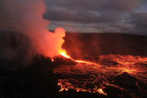
Hawaii , Kilauea :
HAWAIIAN VOLCANO OBSERVATORY DAILY UPDATE , U.S. Geological Survey
Tuesday, November 11, 2025, 8:53 AM HST (Tuesday, November 11, 2025, 18:53 UTC)
19°25’16 » N 155°17’13 » W,
Summit Elevation 4091 ft (1247 m)
Current Volcano Alert Level: WATCH
Current Aviation Color Code: ORANGE
During the lapse in appropriations, the USGS Hawaiian Volcano Observatory (HVO) continues to maintain monitoring networks and issue updates and notifications of volcanic activity via the Hazard Notification Service. Volcano monitoring data will continue to be available on the HVO website. Static website content will not be updated until further notice and information may become outdated over time.
Activity Summary:
Episode 36 of the ongoing Halemaʻumaʻu eruption ended at 4:16 p.m. November 9 after just over 5 hours of high fountains. Only the south vent glowed overnight, but both vents are fuming this morning. Minor glow could be seen on the slopes around the vents and in just a few spots on the crater floor last night. There is not enough data to model a forecast window for the next episode, but it is at least a week away.
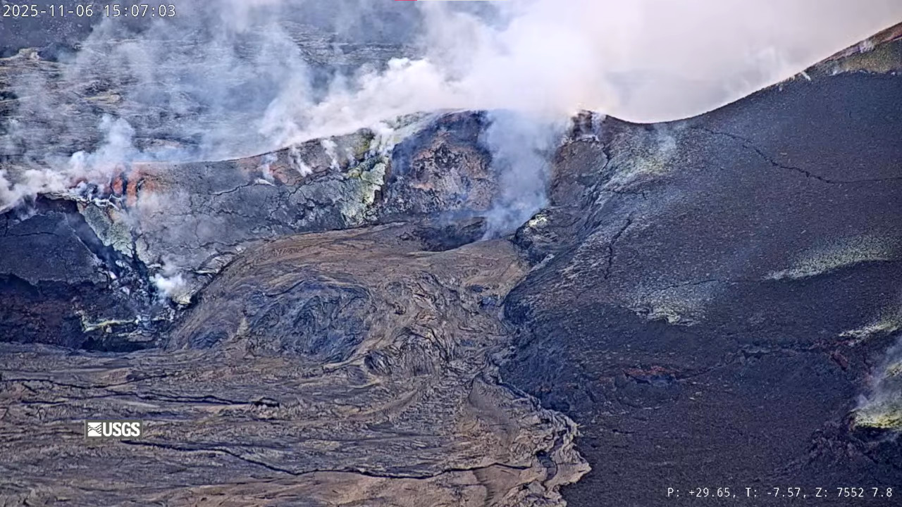
Summit Observations:
Glow was only observed from the south vent overnight, the north vent remained dark, but open. The flows on the slopes around the vents remain incandescent and continue to move slowly downslope. Several small avalanches of incandescent material were observed above the south vent last night. Only a few spots of glow were seen on the flows on the crater floor.
The UWD tiltmeter recorded 23.5 microradians of deflationary tilt during episode 36 and has since recorded about 5.5 microradians of inflationary tilt. Tremor remains at background levels but with regular spikes every 5-10 minutes, likely related to gas pistoning in the vents.
Plumes of gas from both the south and north vents are visible this morning and sulfur dioxide (SO2) gas emissions remain at background levels, typically between 1,200 and 1,500 tonnes per day. Light trade winds have returned to the summit of Kīlauea this morning and are blowing from the northeast to the southwest.
Source : HVO.
Photo : USGS ( 06/11).
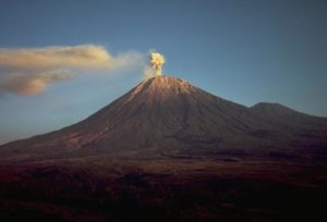
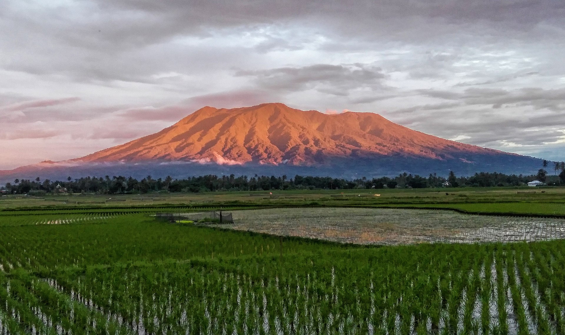
Indonesia , Marapi :
Mount Marapi erupted on Wednesday, November 12, 2025, at 04:41 WIB. An ash column was observed approximately 400 meters above the summit (at an altitude of about 3,291 meters). This column, white to gray in color, was highly intense and moved eastward. The eruption was recorded by a seismograph with a maximum amplitude of 22.7 mm and a duration of 25 seconds.
Seismic Observations
Four local tectonic earthquakes with magnitudes ranging from 4.5 to 31.2 mm and durations ranging from 15 to 26 seconds.
One distant tectonic earthquake with a magnitude of 2.3 mm and a duration of 62 seconds.
Recommendations
1. Communities living near Mount Marapi, as well as climbers, visitors, and tourists, are advised to refrain from all activity within a 3 km radius of the activity center (Verbeek Crater) of Mount Marapi.
2. Communities living near valleys, riverbanks, or streams originating at the summit of Mount Marapi are advised to remain vigilant for the risk of lahars (mudflows), particularly during the rainy season.
Source : Magma Indonésie .
Photo : Dody.bukittinggi