October 8 , 2025.
Italy , Stromboli :
WEEKLY BULLETIN, from September 29, 2025 to October 5, 2025 (publication date: October 7, 2025)
ACTIVITY SUMMARY
Based on the monitoring data, the following points are highlighted:
1) VOLCANOLOGICAL OBSERVATIONS: During the period studied, Strombolian-type eruptive activity was observed. The total hourly explosion frequency fluctuated around high values (15 to 19 events/hour). The intensity was low to medium in the northern area of the crater and low to high in the central-southern area.
2) SEISMOLOGY: The monitored seismological parameters show no significant variation.
3) GROUND DEFORMATION: No significant variation is reported in the time series of ground deformation observation systems.
4) GEOCHEMISTRY: SO2 flux at an average level.
Soil CO2 flux in the Pizzo area (STR02): No update.
C/S ratio in the pen: No update. The most recent data were average (September 9).
Helium isotope ratio (R/Ra): No update.
Soil CO2 flux in the San Bartolo area: Average values.
Soil CO2 flux in the Scari area: High values.
5) SATELLITE OBSERVATIONS: Thermal activity observed by satellite in the summit area was generally low, with some isolated thermal anomalies of moderate level.
VOLCANOLOGICAL OBSERVATIONS
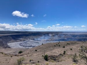
During the observation period, Stromboli’s eruptive activity was characterized by analyzing images recorded by the INGV-OE surveillance cameras located at an altitude of 190 m (SCT-SCV) and at Punta dei Corvi (SPCT). During the observation period, the cameras at an altitude of 190 m (SCT-SCV) were intermittently active from September 30 to October 2. Explosive activity was mainly produced by five eruptive vents located in the North Crater area and at least two vents in the Central-South Crater area.
Observations of Explosive Activity Captured by Surveillance Cameras
Five active vents were observed in the North Crater area (N), two in the N1 sector, and three in the N2 sector. These explosions produced low-intensity explosive activity (the erupted products reached a height of less than 80 m) and sometimes medium-intensity (between 80 and 150 m). The erupted products consisted mainly of coarse materials (bombs and lapilli). The average explosion frequency ranged between 10 and 14 events per hour.
Two main vents were observed in the South-Central Crater (SC) area, exhibiting fine-material explosions and coarse-material explosions, respectively, of varying intensity.
This latter vent, during some explosions, exhibited a wide distribution of projectiles that reached the edges of the crater terrace. The average explosion frequency ranged between 5 and 6 events per hour.
Source : INGV.
Photo : Stromboli stati d’animo / Sebastiano Cannavo
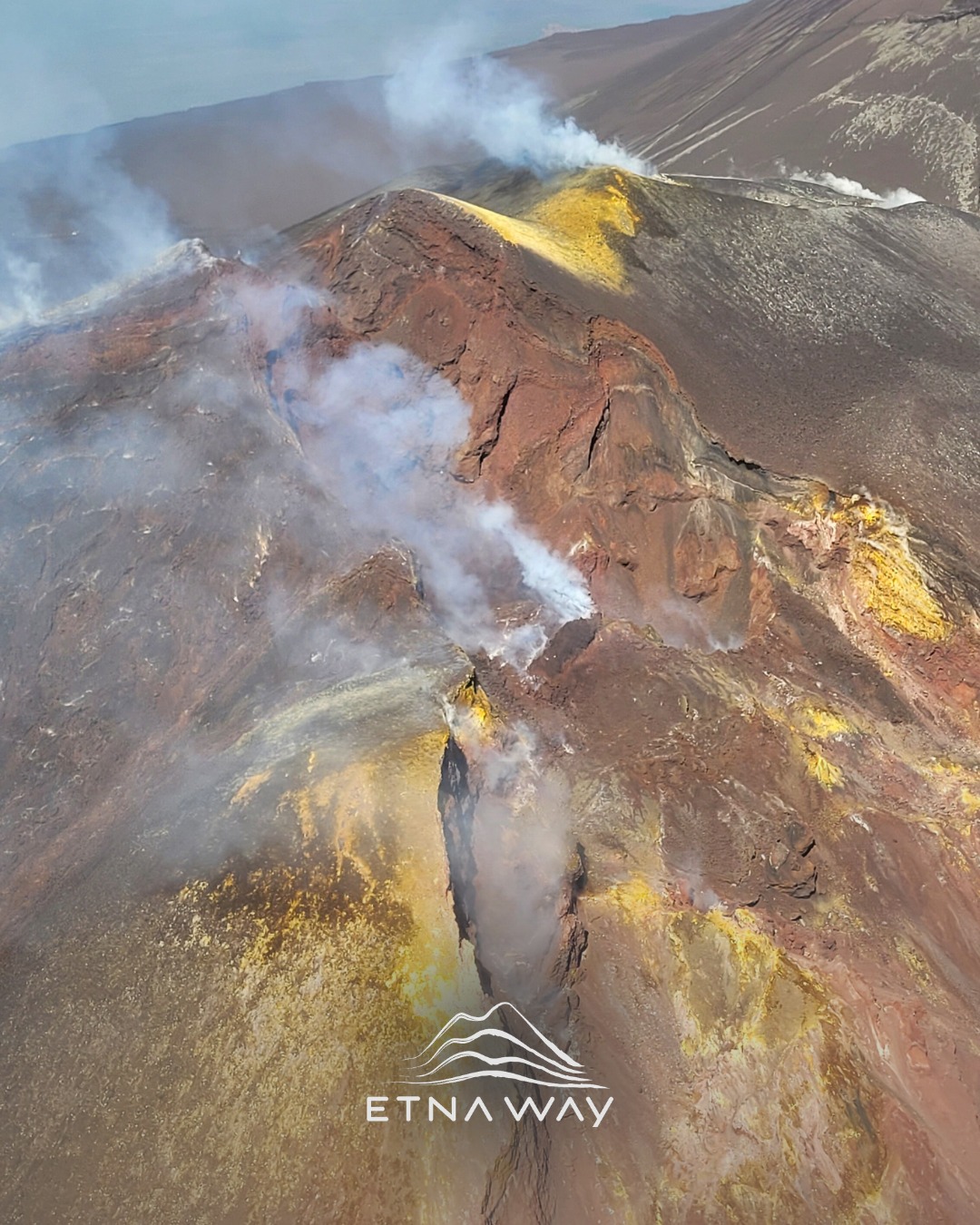
Italy / Sicily , Etna :
WEEKLY BULLETIN, from September 29, 2025 to October 5, 2025 (publication date: October 7, 2025)
ACTIVITY SUMMARY
In light of monitoring data, the following points are highlighted:
VOLCANOLOGICAL OBSERVATIONS: Variable degassing activity in the summit craters.
2) SEISMOLOGY: Low seismic activity due to fracturing. Volcanic tremor amplitude of medium intensity.
3) INFRASOUND: Low infrasound activity.
4) GROUND DEFORMATION: No significant variations are reported in the time series of ground deformation observation systems.
5) GEOCHEMISTRY: Medium intensity SO2 fluxes.
Soil CO2 fluxes (EtnaGas Network): Average values.
Partial pressure of dissolved CO2 in groundwater (EtnaWater Network): No update.
Helium isotope ratio at peripheral sites: The latest data from September 22 are high.
6) SATELLITE OBSERVATIONS: Thermal activity observed by satellite in the summit area was generally low.
VOLCANOLOGICAL OBSERVATIONS
During the period studied, Etna’s activity was characterized by degassing of varying intensity and pattern at the summit craters. The presence of cloud cover or strong winds in the summit area for most of the week severely limited observations of volcanic activity.
SEISMOLOGY
During the week studied, two seismic events of magnitude 2 or greater were recorded. The first event (Ml = 2.0), recorded on September 29 at 09:11 UTC, was located on the southwest flank of Etna (2.0 km southeast of Mount Intraleo), at a depth of approximately 19 km. The second event, recorded on October 5 at 20:27 UTC (Ml = 2.3), was located on the northern flank of the volcano (3.4 km southwest of Moio Alcantara), at a depth of approximately 12 km.
Volcanic tremor: The average amplitude of the volcanic tremor throughout the week remained mostly within the average range. The source of the tremor was located near the northeast crater, at a depth between 1,800 and 2,900 meters above sea level.
Source : INGV.
Photo : Etnaway/ FB.
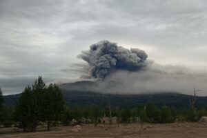
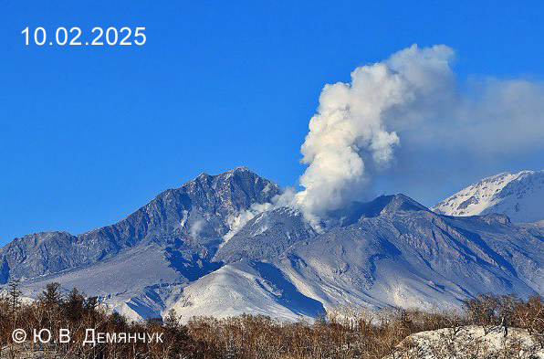
Kamchatka , Sheveluch :
VOLCANO OBSERVATORY NOTICE FOR AVIATION (VONA)
Issued: October 8 , 2025
Volcano: Sheveluch (CAVW #300270)
Current aviation colour code: ORANGE
Previous aviation colour code: orange
Source: KVERT
Notice Number: 2025-110
Volcano Location: N 56 deg 38 min E 161 deg 18 min
Area: Kamchatka, Russia
Summit Elevation: 3283 m (10768.24 ft), the dome elevation ~2500 m (8200 ft)
Volcanic Activity Summary:
An explosive-extrusive eruption of the Young Sheveluch volcano continues. According to video and satellite data by KVERT, explosions sent ash up to 5.4 km a.s.l., ash plume extended for about 25 km to the east-northeast of the volcano.
An explosive-extrusive eruption of the volcano continues. A danger of ash explosions up to 10 km (32,800 ft) a.s.l. remains. Ongoing activity could affect low-flying aircraft.
Volcanic cloud height:
5300-5400 m (17384-17712 ft) AMSL Time and method of ash plume/cloud height determination: 20251008/0131Z – Video data
Other volcanic cloud information:
Distance of ash plume/cloud of the volcano: 25 km (16 mi)
Direction of drift of ash plume/cloud of the volcano: ENE / azimuth 64 deg
Time and method of ash plume/cloud determination: 20251008/0150Z – Himawari-9 14m15
Source : Kvert.
Photo : Yu. Demyanchuk. IVyS Branche extrême-orientale de l’Académie des sciences de Russie, KVERT
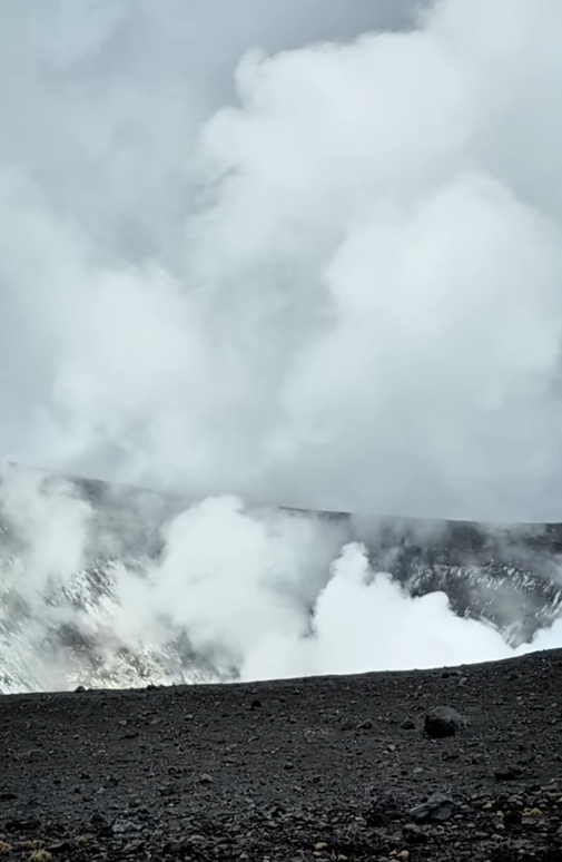
Colombia , Puracé – Los Coconucos volcanic chain:
Popayán, October 7, 2025, 5:00 a.m.
Regarding the monitoring of the activity of the Puracé Volcano – Los Coconucos Volcanic Range, the Colombian Geological Survey (SGC), an entity affiliated with the Ministry of Mines and Energy, reports that:
During the week of September 30 to October 6, 2025, a signal classified as continuous volcanic tremor continued to be persistently recorded. This signal is associated with fluid dynamics in volcanic conduits and, on October 2, was associated with increased degassing from the Puracé Volcano crater. The earthquakes related to fluid movement were characterized by low energy input and occurred mainly beneath the western flank of the Puracé Volcano crater, at a depth of less than 1 km. Compared to previous weeks, the number of fracture earthquakes remained stable and was located mainly between the Puracé and Piocollo volcanoes, at depths ranging from 1 to 3 km, with magnitudes up to 1.2.
Satellite measurements and field instruments showed that sulfur dioxide (SO2) emissions continued, at levels similar to those of previous weeks.
Furthermore, the slow deformation process detected after the eruption of Curiquinga Volcano on January 20, 2025, is continuing.
Images captured by satellite sensors and visible and infrared webcams continued to show degassing processes, with a maximum column height of 1.7 km, measured from the summit of Puracé Volcano, as well as thermal anomalies inside the crater and in the fumarole field on the outer rim.
In conclusion, the variations observed at Puracé Volcano – Los Coconucos Volcanic Chain indicate that the system remains active and that monitoring parameters remain above their reference values. Therefore, the community is advised to avoid any ascent to the upper reaches of the volcanic chain.
At yellow alert status, phenomena such as sporadic ash emissions (minor eruptions of limited magnitude and effects, whose dispersion depends on wind direction), the presence of incandescent light, small explosions in the crater, low-energy thermal anomalies, noise, felt earthquakes, odors, precipitation of elemental sulfur near the crater, in hot springs and fumaroles, as well as degassing outside the crater, may occur. Fissure formation and the presence of minor lahars, among other things, may also occur.
The alert status for volcanic activity remains at yellow alert: an active volcano exhibiting changes in the baseline behavior of monitored parameters and other manifestations.
Source et photo : SGC.
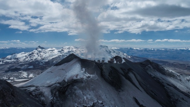
Peru , Sabancaya :
Bulletin analysis period: September 29 to October 5, 2025.
Volcanic Alert Level
Orange Alert Level: The volcano is significantly increasing its eruptive activity. There has been an increase in seismic activity, frequent explosions, and the emission of ash and ballistic blocks.
Analysis
89 earthquakes associated with the circulation of magmatic fluids within the volcano have been recorded, in addition to earthquakes related to rock fracturing. No volcanic explosions occurred during this period.
Columns of water vapor and gas reaching 1,200 m high were observed above the volcano’s summit. The predominant dispersion of these products was toward the eastern and northeast sectors of the volcano. The affected radius was less than 10 km.
No significant deformation was recorded within the volcanic edifice.
Low sulfur dioxide (SO2) emissions were observed, averaging 163 tons/day. In addition, five thermal anomalies of less than 1 MW were detected, associated with the proximity of a magmatic body to the crater surface.
Conclusions
The IGP reports that the Sabancaya Volcano continues its eruption process. During this period, no volcanic explosions have been recorded; however, water vapor and gas emissions have been observed, reaching a maximum altitude of 1,200 m above the volcano’s summit, in addition to seismic activity associated with the movement of magmatic fluids and internal fracturing. Therefore, the Volcanic Alert Level remains orange.
Recommendations
Adopt preventive measures in accordance with the current orange Volcanic Alert Level.
Do not approach within a 12 km radius of the crater. In case of ashfall, cover your nose and mouth with damp cloths or a mask. Keep doors and windows closed.
Source and photo: IGP.