June 18 , 2025.
Indonesia , Lewotobi Laki-Laki :
INCREASE IN THE ACTIVITY LEVEL OF G. LEWOTOBI LAKI-LAKI FROM LEVEL III (SIAGA) TO LEVEL IV (AWAS) June 17, 2025 at 3:00 PM WITA
Smoke from the explosion is visible around the crater, with low to moderate pressure. It is also visible in the northwest area of the summit, which resembles a fissure and is generally weak, while in the solfatara penetration, on the northeast side, the smoke appears thin. The appearance of smoke in the crater (solfatara) is due to the presence of an alteration zone (weak zone), so that smoke escapes from the area. This area is likely to experience a directed explosion (a direct eruption in a single direction) that could move northwest, northeast, and westward from the summit.
Seismic data shows a significant increase in deep volcanic earthquakes, which occur on average only 8 to 10 times per day, but on June 17, 2025, 50 were recorded in just 2 hours. The seismic data from June 16 and 17, 2025, at 2:00 p.m. (local time), are 5 emission earthquakes, 18 nonharmonic tremors, 3 low-frequency earthquakes, 3 hybrid earthquakes, 52 deep volcanic earthquakes, and 7 distant tectonic earthquakes.
Tiltmeter and GPS deformation data show signs of inflation, as do InSAR data, which are consistent with data showing inflation anomalies. These data indicate internal pressure within the volcano, which is likely to erupt.
The results of visual and instrumental analyses show an increase in the activity of the Lewotobi Laki-laki volcano. Its activity level has therefore increased from level III (SIAGA) to level IV (AWAS) as of June 17, 2025, at 3:00 p.m. (local time).
The public and tourists are advised not to engage in any activities within a 7 km radius and 8 km in the southwest and northeast sectors of the eruption site, to remain calm, and to follow the instructions of local authorities.
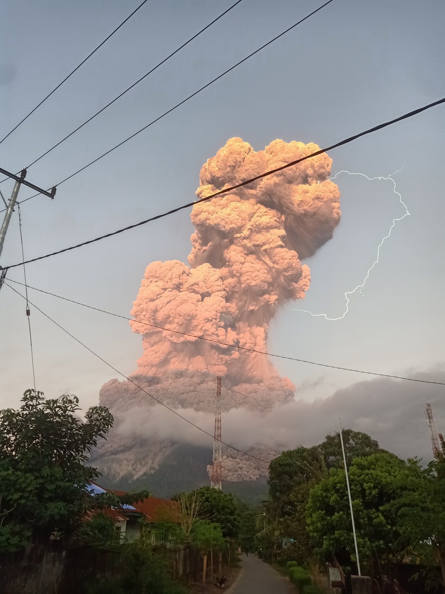
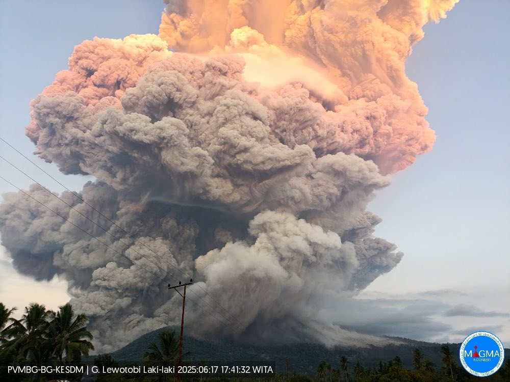
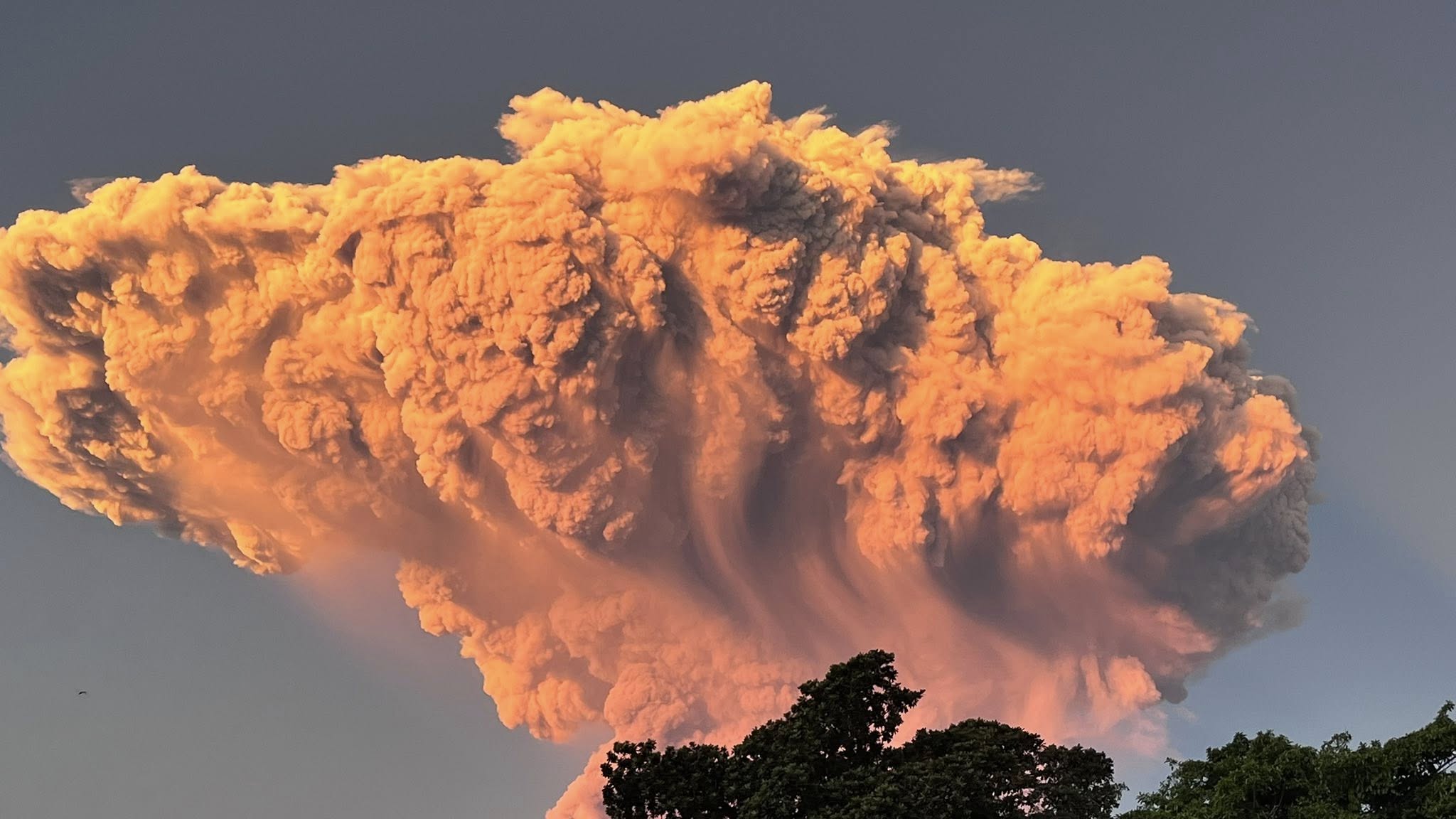
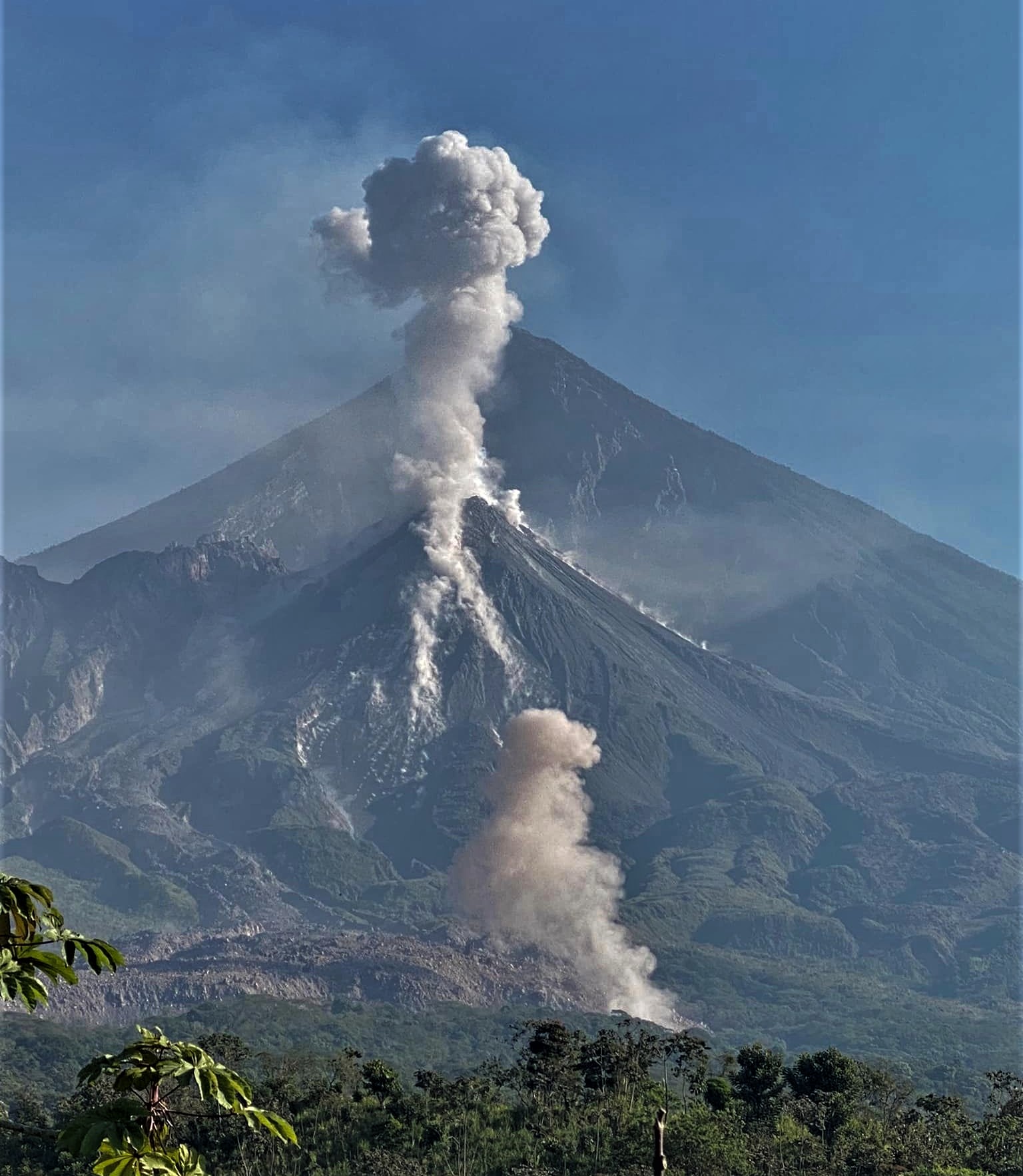
An eruption of Mount Lewotobi Laki-laki occurred on Tuesday, June 17, 2025, at 09:35 UTC (5:35 PM local time). The observed ash column was 11,584 m (37,069 ft) above sea level or 10,000 m (32,000 ft) above the summit. The ash column was gray and of strong intensity, oriented southwest and west. At the time of this report, the eruption was still ongoing.
VOLCANO OBSERVATORY NOTICE FOR AVIATION – VONA
Issued : June 17 , 2025
Volcano : Lewotobi Laki-laki (264180)
Current Aviation Colour Code : RED
Previous Aviation Colour Code : orange
Source : Lewotobi Laki-laki Volcano Observatory
Notice Number : 2025LWK339
Volcano Location : S 08 deg 32 min 20 sec E 122 deg 46 min 06 sec
Area : East Nusa Tenggara, Indonesia
Summit Elevation : 5069 FT (1584 M)
Volcanic Activity Summary :
Eruption with volcanic ash cloud at 09h35 UTC (17h35 local).
Volcanic Cloud Height :
Best estimate of ash-cloud top is around 37069 FT (11584 M) above sea level or 32000 FT (10000 M) above summit. May be higher than what can be observed clearly. Source of height data: ground observer.
Other Volcanic Cloud Information :
Ash cloud moving from north, northeast, east, southeast, south, southwest, west to northwest. Volcanic ash is observed to be gray to dark. The intensity of volcanic ash is observed to be thick.
Remarks :
Eruption and ash emission is continuing. Eruption recorded on seismogram with maximum amplitude 47.3 mm. Tremor recorded on seismogram with maximum amplitude 7.4 mm.
Source : Magma Indonésie.
Photos : Magma Indonésie , Stela MaLinova , Happy dive Retreat .
Italy / Sicily , Etna :
WEEKLY BULLETIN, from June 9, 2025 to June 15, 2025 (publication date: June 17, 2025)
ACTIVITY STATUS SUMMARY
Based on monitoring data, the following points are highlighted:
1) VOLCANOLOGICAL OBSERVATIONS: Variable degassing activity in the summit craters.
2) SEISMOLOGICAL OBSERVATIONS: Absence of seismic activity due to fracturing with Ml >=2.0. Tremor amplitude is mainly low.
3) INFRASOUND: Medium to high intensity infrasound activity.
4) GROUND DEFORMATION: Ground deformation monitoring networks have not recorded any significant variations. 5) GEOCHEMISTRY: Medium to low SO2 flux
6) SATELLITE OBSERVATIONS: Thermal activity observed by satellite in the summit area was generally low in intensity, with some moderate thermal anomalies.
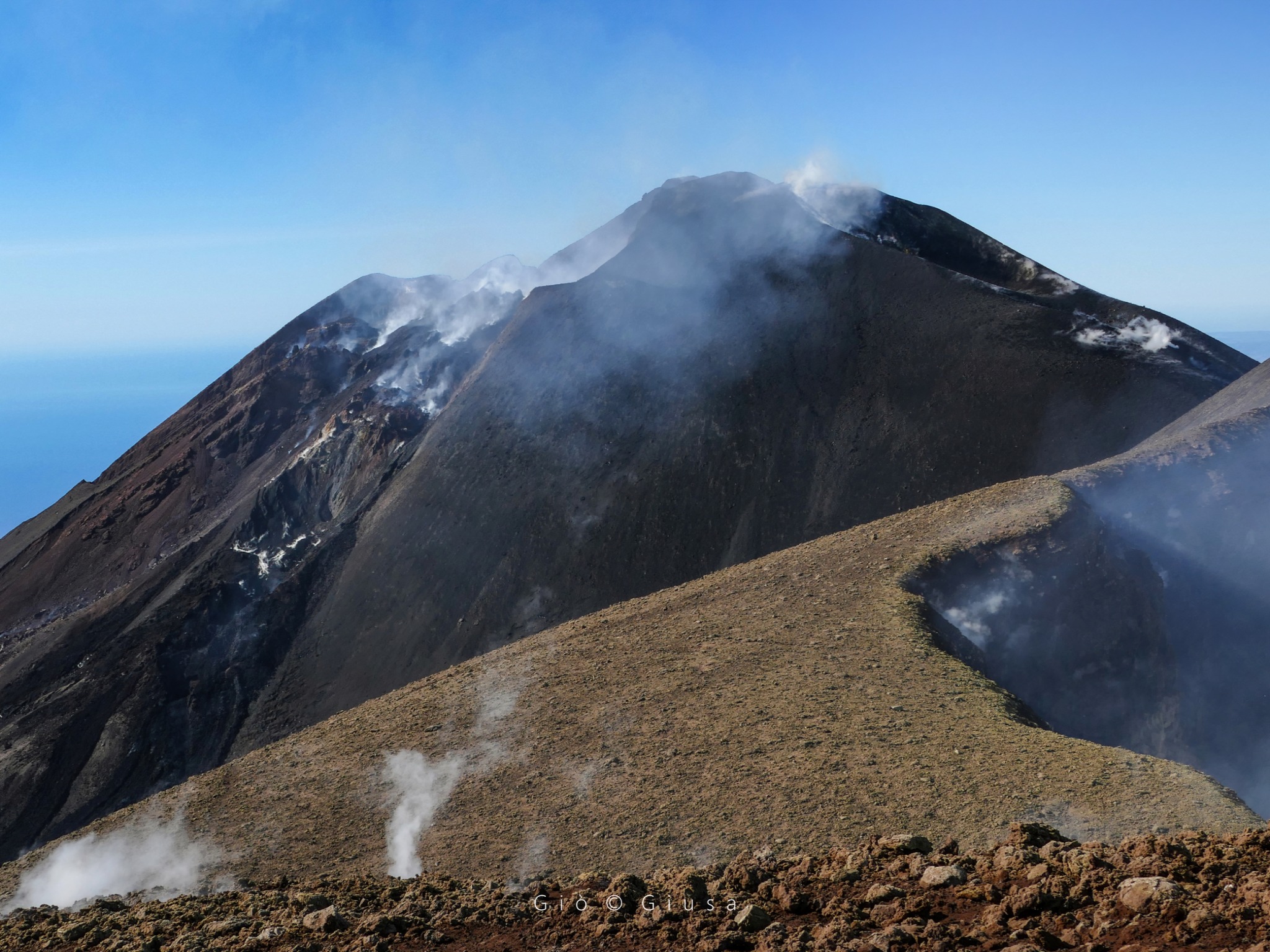
The northeast flank of the Southeast Crater with its fractures seen from the rim of the Northeast Crater.
VOLCANOLOGICAL OBSERVATIONS
Monitoring of Etna’s volcanic activity was carried out through the analysis of images from the INGV surveillance camera network, Osservatorio Etneo (INGV-OE) and an inspection of the summit area on June 10. During the period studied, Etna’s activity was characterized by continuous degassing of varying intensity and pattern at the summit craters.
More specifically, degassing activity of varying intensity was observed at the Bocca Nuova Crater (BN) and the Voragine Crater (VOR), and was particularly intense and impulsive at the Northeast Crater (CNE). At the Southeast Crater, degassing was fumarolic in nature from the inner walls and along the crater rim.
Volcanic Tremor:
The average amplitude of volcanic tremor remained generally low throughout the week. The centroids of the volcanic tremor sources were located between the Northeast and Southeast Craters, at depths ranging from 1,800 to 3,000 meters above mean sea level.
Source : INGV .
Photo : Gio Giusa .
Italy , Stromboli :
WEEKLY BULLETIN, from June 9, 2025 to June 15, 2025 (publication date: June 17, 2025)
ACTIVITY STATUS SUMMARY
Based on monitoring data, the following points are highlighted:
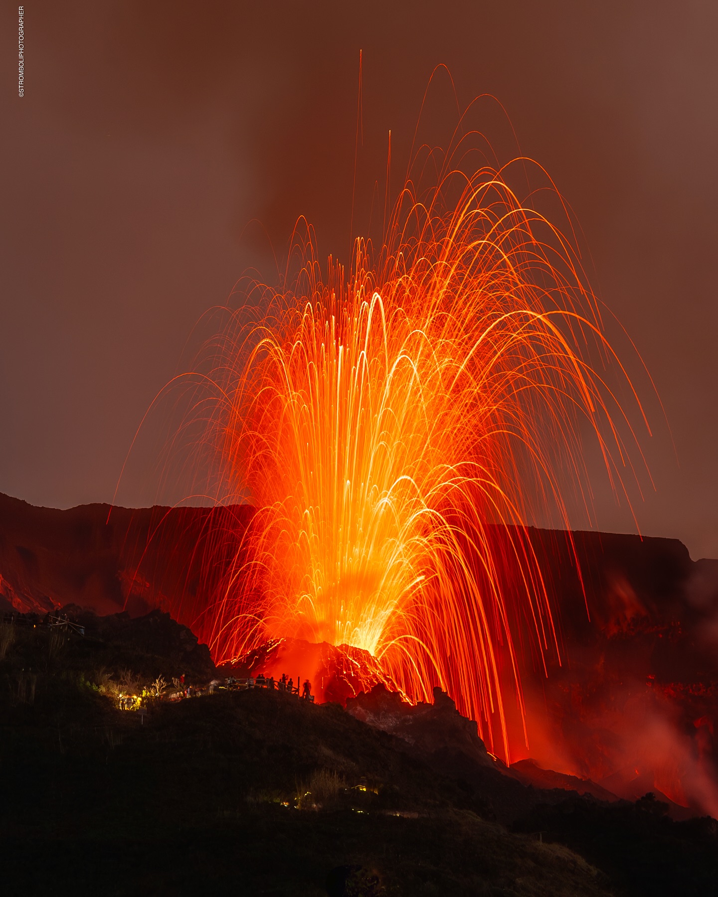
1) VOLCANOLOGICAL OBSERVATIONS: During this period, ordinary Strombolian eruptive activity was observed, with weak spattering. The total hourly frequency ranged between average values (8 to 12 events/h). The intensity of the explosions was low and medium in the North and South-Central crater areas.
2) SEISMOLOGY: NOTE: This bulletin is produced from data acquired from a maximum of 8 stations.
The monitored seismological parameters do not show any significant variations. 3) GROUND DEFORMATION: Ground deformation monitoring networks did not show any significant variations.
4) GEOCHEMISTRY: SO2 fluxes: moderate.
5) SATELLITE OBSERVATIONS: Thermal activity observed by satellite in the summit area was generally low in intensity, with some isolated moderate thermal anomalies.
VOLCANOLOGICAL OBSERVATIONS
During the observation period, Stromboli’s eruptive activity was characterized by analyzing images recorded by INGV-OE surveillance cameras located at an altitude of 190 m (SCT-SCV) and at Punta dei Corvi (SPCT). Explosive activity was mainly produced by four eruptive vents located in the North Crater area and by at least two vents located in the Central-South area.
Observations of explosive activity recorded by surveillance cameras
In the North (N) Crater area, four active vents were observed, producing explosive activity of low intensity (less than 80 m in height) and sometimes of medium intensity (less than 150 m in height). Furthermore, on June 15, weak eruptions were observed in the N2 sector. The eruptive products consisted mainly of coarse materials (bombs and lapilli). The average explosion frequency ranged from 4 to 9 events per hour.
In the South-Central (SC) area, explosive activity was produced by at least two vents; the explosions were mainly of low and medium intensity, composed of fine materials (ash), sometimes mixed with coarse materials (lapilli and bombs). The average explosion frequency ranged from 2 to 4 events per hour.
Source : INGV .
Photo : Stromboli stati d’animo / Sebastiano Cannavo .
Colombia , Chiles / Cerro Negro :
San Juan de Pasto, June 17, 2025, 3:50 p.m.
Regarding the monitoring of the activity of the Chiles-Cerro Negro Volcanic Complex (CVCCN), the Colombian Geological Survey (SGC), an entity affiliated with the Ministry of Mines and Energy, reports that:
From June 10 to 16, 2025, the main variations in the monitored parameters compared to the previous week were:
● Both the occurrence and the released seismic energy increased.
The predominance of seismicity associated with rock fracture continues, and a significant contribution from events related to fluid dynamics is also evident.
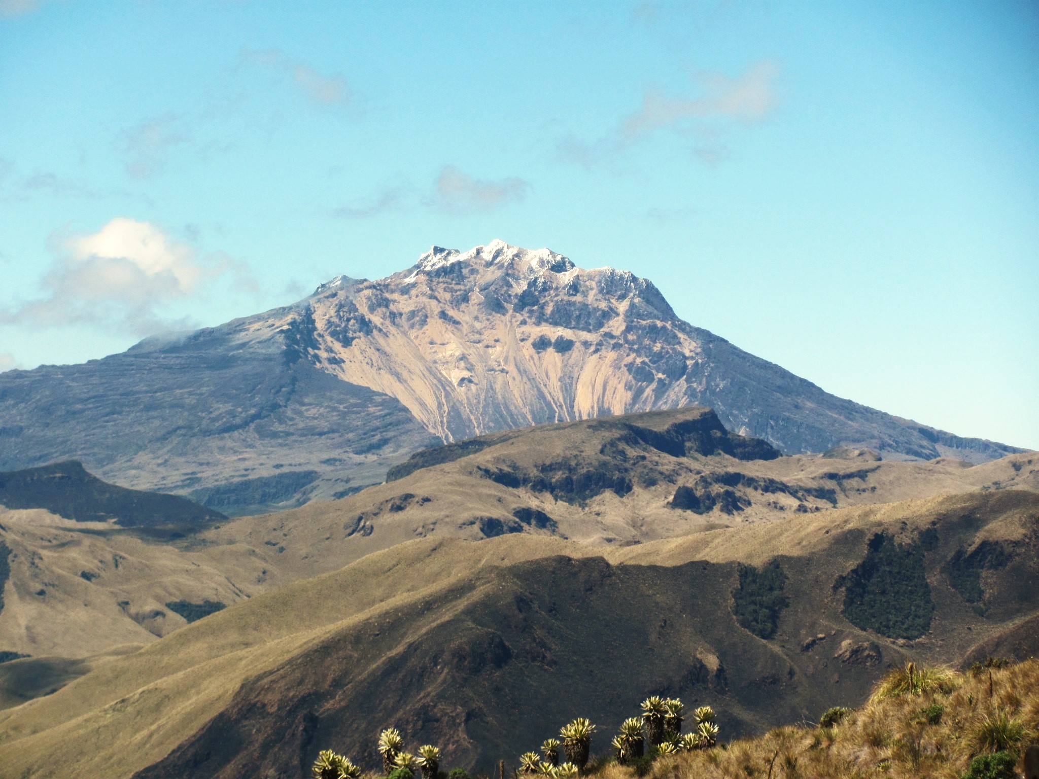
● The localized earthquakes were located mainly beneath the Chiles Volcano collapse zone, at depths between 2.5 and 4.4 km from the summit of Chiles (approximately 4,700 m above sea level), with magnitudes less than 1. A few other events were located west of Chiles, near both volcanoes, with shallow depths and a maximum local magnitude of 1.2.
● Analysis of data from satellite sensors and ground stations continues to show changes related to deformation processes in the volcanic area. Based on the evaluation and correlation of the monitored parameters, the SGC recommends closely monitoring developments through weekly bulletins and other information published through our official channels, as well as instructions from local and departmental authorities and the National Disaster Risk Management Unit (UNGRD).
Volcanic activity remains on yellow alert: active volcano with changes in the basic behavior of monitored parameters and other manifestations.
Source et photo : SGC.
Guatemala , Santiaguito :
Atmospheric Conditions: Clear skies.
Wind: East.
Precipitation: 87.2 mm at STG6.
Activity:
Crater activity is observed with white fumaroles at an altitude of 3,500 meters. They are moving westward. Weak to moderate explosions have been observed, ejecting columns of gray ash at an altitude of 3,700 meters.
They are spreading west and southwest, for approximately 20 kilometers. Ash falls have been reported in the villages of San Marcos and Loma Linda Palajunoj, among others, in the area. This activity generates constant avalanches, some of which are accompanied by short-distance pyroclastic flows. Due to the activity described, larger pyroclastic flows, similar to those of 2022, could occur. Therefore, it is recommended not to approach the domed areas, nor to remain near or in the ravines near the volcanic complex. Please note that isolated rains may still occur in the area.
Source : Insivumeh .
Photo : Armando Pineda