June 07 , 2025.
Guatemala , Fuego :
Weather conditions: Clear.
Wind: Northeast.
Precipitation: 133.5 mm.
Activity:
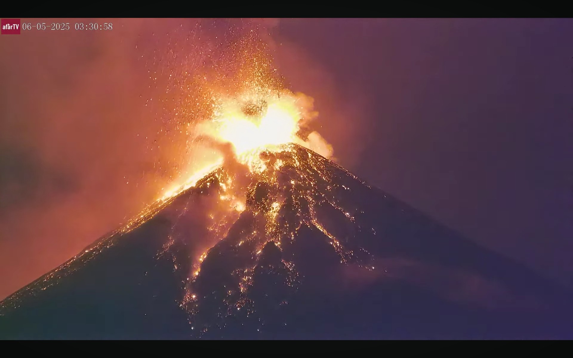
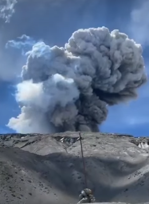
The Fuego Volcano Volcano Observatory (OVFGO) reports that, during the night and early morning, the crater and its southern, southwest, and eastern flanks were observed to be incandescent. Explosions were generated, accompanied by columns of ash and gas reaching approximately 4,800 meters (15,777 feet), moving toward the west and southwest of the volcanic complex, accompanied by rumbling and noises similar to those of a locomotive. Ash remnants are observed in the volcanic area, with steam and ash rising in the ravines due to the deposition of pyroclastic flows following the eruption. Due to this activity, periods of increased volatility may still occur, generating pyroclastic flows at any time, making it dangerous to be near or in the ravines surrounding Fuego Volcano. It is also important to remain on the plateau. Keep in mind that rain persists in the volcanic area and will continue to generate lahars in the ravines surrounding Fuego Volcano. Therefore, extreme caution is recommended when driving through. (An eruption report will be published in the coming hours.)
Information Bulletin 200-2025
Thanks to volcanological monitoring carried out by the CONRED system, it is reported that the eruptive activity of the Fuego volcano decreased significantly in the early morning of June 6. According to INSIVUMEH, these parameters will continue to decrease as the lava flow, which is still active in the crater towards the Ceniza ravine, ceases.
The special volcanological bulletin indicates that webcam recordings no longer show sources or pulses of incandescent material, as well as the absence of ash suspended in the atmosphere, after just over 30 hours of eruptive columns, lava flows, and the descent of pyroclastic density currents.
It is important to note that due to the precipitation already recorded, forecasts, and volcanic activity, lahars could continue to flow down most of the volcano’s ravines. Several channels are therefore blocked by material carried by these lava flows, hindering vehicle traffic.
Volcanic activity is expected to continue in the coming days, with small explosions and lava flows. The CONRED system will continue to monitor the volcano, communicate with coordinators and territorial authorities, and implement the procedures established in the National Response Plan for these events.
SE-CONRED recommends that the public continue to stay informed via the official CONRED and INSIVUMEH accounts, avoid crossing or staying near rivers or ravines on the volcano due to lahars, and follow the instructions of local authorities to respect the established climbing routes on the Acatenango Volcano and other prevention guidelines.
Source : Insivumeh , Conred .
Photo : Afar TV.
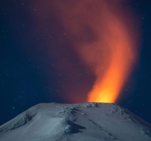
Alaska , Spurr :
Unrest continues at Mount Spurr. The level of activity is still above background, but lower than observed in early 2025. This decrease in activity suggests that the magma intrusion beneath Mount Spurr has stalled. The likelihood of an eruption has declined since March, but fluctuations in unrest are not uncommon, and explosive eruptions like those in 1953 and 1992 are still possible. Should unrest escalate, we expect increases in seismic activity, gas emissions, surface deformation, and surface heating.
During the past week, 45 earthquakes were located, all smaller than magnitude 1. This is a decrease in the number of located earthquakes compared to recent weeks, but within the observed variability from week to week during this entire period of unrest. Minor sulfur dioxide emissions were detected in satellite data on one day this week. Ground deformation at Mount Spurr has paused over the past two months, like the pause that occurred for several weeks in November and December 2024. An apparent increase in observed deformation over the past month is likely due to seasonal environmental factors affecting the equipment and not magmatic movement.
Views of the summit from local web cameras showed a vapor plume when viewing conditions were clear. No significant surface changes were observed at Mount Spurr over the past week.
AVO continues to closely monitor activity at Mount Spurr for signals indicating the volcano is moving closer to an eruption using local seismic, infrasound, and GNSS (GPS) stations, web cameras, airborne and satellite gas measurements, regional infrasound, lightning networks, and satellite images. Based on previous eruptions, additional changes in earthquakes, ground deformation, the summit lake, and fumaroles would be expected if magma moves closer to the surface. Therefore, if an eruption occurred, it would be preceded by additional signals allowing advance warning
Source : AVO.
Photo : Loewen, Matt / Alaska Volcano Observatory / U.S. Geological Survey.
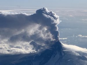
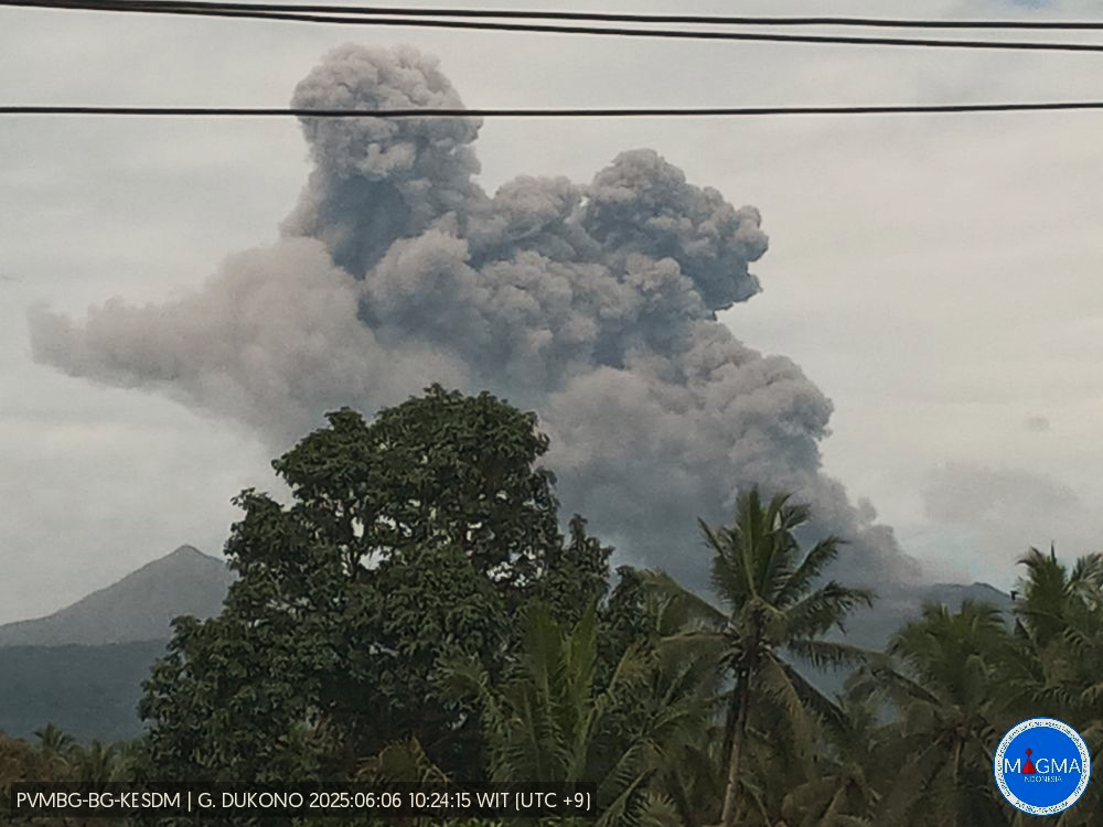
Indonesia , Dukono :
Mount Dukono erupted on Friday, June 6, 2025, at 10:57 WIT. The observed ash column was ± 1,100 m above the summit (± 2,187 m above sea level). The ash column was white to gray, with a strong intensity, oriented toward the East. This eruption was recorded by seismograph with a maximum amplitude of 21 mm and a duration of 71.38 seconds.
Seismicity Observation:
167 eruption earthquakes with an amplitude of 6 to 34 mm and a duration of 32.1 to 71.38 seconds.
1 deep volcanic earthquake with an amplitude of 28 mm, an amplitude of 2.12 seconds, and a duration of 25.04 seconds.
1 distant tectonic earthquake with an amplitude of 14 mm, an amplitude of 17.43 seconds, and a duration of 75.78 seconds.
1 continuous tremor with an amplitude of 2 to 4 mm, with a dominant value of 3 mm.
Recommendation
(1) The community around Mount Dukono and visitors/tourists are advised not to engage in any activities, climb, or approach the Malupang Warirang crater within a 4 km radius.
(2) Since volcanic ash eruptions occur periodically and the distribution of ash follows the direction and speed of the wind, so the area where the ash lands is not constant, people around Mount Dukono are recommended to always carry masks/nose and mouth covers to use when needed to avoid the threat of volcanic ash to the respiratory system.
Source et photo : Magma Indonésie .
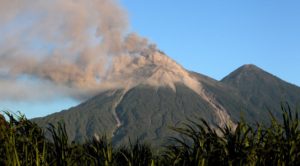
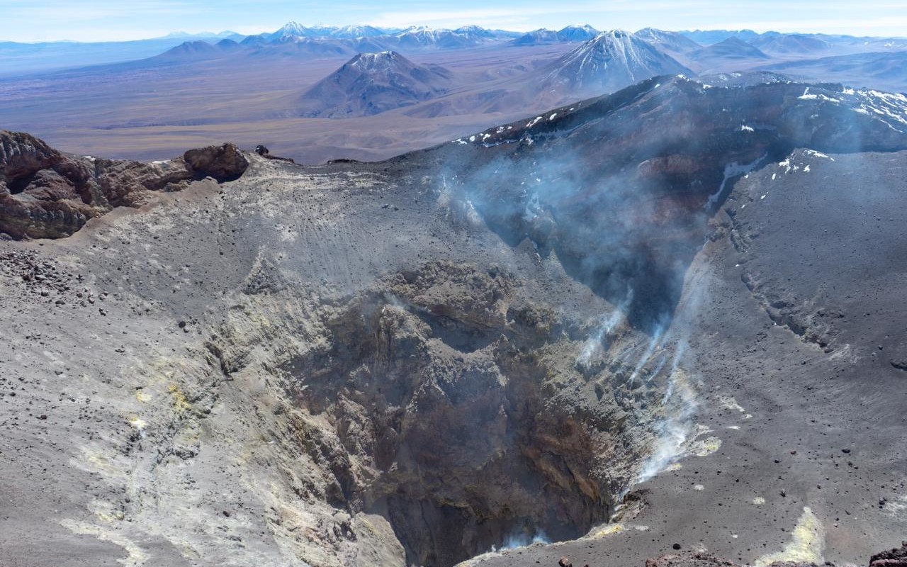
Chile , Lascar :
Seismology
Seismological activity during the period was characterized by the following:
2 VT-type seismic events, associated with rock fracturing (volcano-tectonics).
9 LP-type seismic events, associated with fluid dynamics within the volcanic system (long period). The magnitude of the largest earthquake, estimated using the reduced displacement (DR) parameter, was 2.9 cm².
Fluid Geochemistry
Sulfur dioxide (SO₂) emission data obtained by differential optical absorption spectroscopy (DOAS), corresponding to the Emu station, located 6 km east-southeast (ESE) of the active crater, showed an average SO₂ flux of 851 ± 66 t/d for the period evaluated, with a maximum daily value of 1,409 t/d on May 23. Two anomalies were reported in satellite images obtained with the Tropospheric Monitoring Instrument (TROPOMI) regarding sulfur dioxide (SO₂) emissions into the atmosphere in areas near the volcano. The peak emission was recorded on May 28, reaching 218 tons of SO₂. These data were published by the Mounts Project and Global Sulfur Dioxide Monitoring.
Satellite Thermal Anomalies
During this period, 37 thermal anomalies were detected in the volcanic area, according to the MIROVA platform. The highest thermal energy recorded was 3.3 MW on May 17 (according to the MODIS sensor) and 4.5 MW on May 24 (according to the VIIRS sensor). Sentinel 2-L2A satellite images, taken on May 22 and 27 using a combination of false-color bands, show that a clearly identifiable three-zone thermal pattern persists in the active crater. Furthermore, the NHI TOOLS platform estimated on May 22 that the total area of the hotspot reached 8,000 m², which is considered a moderate value. Although thermal anomalies have decreased slightly, they remain above the usual base level for this volcano.
Geodesy
Geodetic activity for the period was characterized by:
– low-amplitude rates of horizontal components from GNSS stations;
– medium-amplitude rates (0.9 cm/month) of vertical components from one of the GNSS monitoring stations; however, this is not related to changes in the volcano’s internal dynamics; therefore, there is no evidence of significant changes.
Recent instrumental recordings confirm that the volcanic system continues to show signs of unusual internal and surface activity. However, seismic activity has shown a slow and gradual decline in the frequency of events, a trend that has continued in recent weeks. At the surface, incandescence and recurrent gas emissions persist, although gas columns have been weaker compared to the previous period. Daily sulfur dioxide (SO₂) fluxes remain below the threshold considered abnormal for this volcano. However, satellite alerts continue to record SO₂ emissions, thermal anomalies, and radiance in the active crater, confirming the continuation of an anomalous process. In this context, surface parameters allow us to infer the permanence of an ongoing process, which, combined with the experience of sudden increases in activity at the crater, as has occurred in previous years, suggests maintaining the Volcanic Technical Alert at: YELLOW TECHNICAL ALERT: Changes in the behavior of volcanic activity.
Source : Sernageomin .
Photo : Vulcanopro.
Colombia , Nevado del Ruiz :
Manizales, June 3, 2025, 5:15 p.m.
Regarding the monitoring of the activity of the Nevado del Ruiz volcano, the Colombian Geological Survey (SGC), an entity attached to the Ministry of Mines and Energy, reports that:
From May 27 to June 2, 2025, the volcano continued to exhibit unstable behavior. Compared to the previous week, the main variations in the monitored parameters were:
– Seismic signals related to fluid dynamics in volcanic conduits recorded an increase in the number of events and a decrease in the seismic energy released compared to the previous week. The energy levels of the seismic signals were low. The cameras (conventional or thermographic) used to monitor the volcano confirmed two pulsatile ash emissions associated with the seismic signals. However, due to adverse atmospheric conditions, no variation in the apparent temperature of the ejected materials was observed in connection with these ash emissions.
Seismic activity associated with rock fracturing processes within the volcanic edifice has decreased the number of recorded events and increased the released seismic energy. Most of the seismic events were located within 6 km of the Arenas crater, mainly on the northeast and south-southwest flanks and, to a lesser extent, on the east and west flanks of the volcano, at depths between 2 and 8 km from the volcanic summit. In addition, earthquakes were recorded in the Arenas crater within 3 km of the summit. The strongest earthquake of the week was recorded on May 28 at 5:25 a.m., with a magnitude of 1.9, 4 km northeast of the crater, at a depth of 5 km from the volcano’s summit. Water vapor and gas emissions, primarily sulfur dioxide (SO₂), into the atmosphere from the Arenas crater have been variable and have been decreasing. Satellite monitoring, conducted to complement the assessment of this parameter, also showed a decrease in SO₂ emissions.
– The vertical height of the gas and water vapor column generally remained below 500 m, with a maximum of 600 m (measured above the volcano’s summit). In terms of dispersion, the maximum height reached was 400 m during the pulsating ash emission recorded on May 27 at 8:37 a.m. The direction of dispersion showed a predominant trend toward the northwest flank of the volcano, with occasional variations toward the west-northwest, southwest, and west-southwest.
– When monitoring thermal anomalies at the floor of Arenas Crater using satellite monitoring platforms, detection was limited due to the atmospheric conditions of high cloud cover in the area; however, some reports of low energy levels were obtained.
Source et photo : SGC.