February 01 , 2023.
Vanuatu , Epi :
East Epi sub-marine volcano activity update issued by VMGD
Early this morning, reports and observations from locals at Epi indicate an increase in the activity of the East Epi sub-marine volcano at around 7:48am with steam over the sub-marine volcano area. There is also reports of Sulphur dioxide followed by phreatic explosions propelling ash some 100 meters high.
People on Epi, Tongoa and the surrounding islands are advised to stay clear of the coast as phreatic explosions may continue and could generate small waves.
Vanuatu Meteorology and Geohazards Department will continue to monitor the volcano activity and update when more information become available.
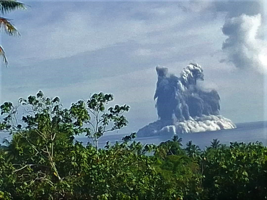
The volcano alert level of East Epi sub-marine volcano is increased to Volcano Alert Level 1.
Due to ongoing volcanic activity at East Epi sub-marine volcano with phreatic explosions, light degassing and emissions of ash, the danger zone is at 10km radius around the East Epi sub-marine volcano. Latest observations confirmed that the volcanic cone is building up with the continuous ash emissions.
Aviation and Mariners are advised that with the ongoing sub-marine volcano activity, the danger zone is along the East side of Epi island.
People on Epi and surrounding islands are also advised to stay on alert for any large earthquake associated with the ongoing volcanic eruptions that could trigger a possible tsunami.
A large caldera, with submarine post-caldera cones active in historical time, lies off the eastern coast of Epi Island. Epi Island itself, located slightly west of the main New Hebrides volcanic arc, largely consists of two Quaternary volcanoes, Mount Allombei on the west and Pomare (Tavani Kutali) on the east. Tavani Ruro, which forms an elongated eastern extension of Epi Island across a narrow isthmus, is related to Kuwae caldera to the east. Pomare volcano is the highest point on the island and has three well-preserved subsidiary cones to the east with youthful summit craters.
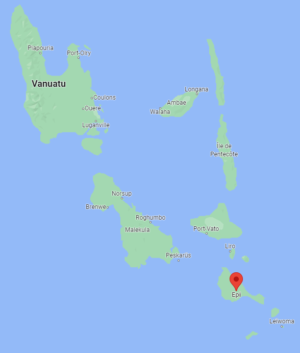
Pomare volcano is truncated on its eastern side by the largely submarine East Epi caldera, which has been the source of all historical eruptions. Three small submarine basaltic and dacitic cones, known as Epi A, Epi B, and Epi C, are located along the northern rim of the breached caldera. Ephemeral islands were formed during eruptions in 1920 and 1953, and the summit of the shallowest cone, Epi B, was at 34 m below sea level at the time of a 2001 survey.
Photo : Mayline Leleny, google maps
Italy , Stromboli :
WEEKLY BULLETIN, from January 23, 2023 to January 29, 2023. (issue date January 31, 2023).
ACTIVITY STATUS SUMMARY
In the light of the monitoring data, it is highlighted:
1) VOLCANOLOGICAL OBSERVATIONS: During this period, normal Strombolian activity was observed with spattering activity and lava overflow in the N crater area. The total hourly frequency oscillated between low values (5 events/h ) and average (12 events/h). The intensity of the explosions was mainly medium and low in the North crater area and medium in the South Center crater area.
2) SEISMOLOGY: The seismological parameters do not show significant variations.
3) GROUND DEFORMATIONS: The ground deformation monitoring networks did not show any significant variations.
4) GEOCHEMISTRY: The flow of SO2 at an average level
CO2 flux in the crater area: stable on average values
CO2/SO2 ratio on high values.
Isotope ratio of helium in groundwater: there are no updates, the last figure dated 20-12-22 on medium-high values.
5) SATELLITE OBSERVATIONS: The thermal activity observed from the satellite was generally weak.

VOLCANOLOGICAL OBSERVATIONS
During the observation period, the eruptive activity of Stromboli was characterized by the analysis of the images recorded by the surveillance cameras of the INGV-OE at an altitude of 190 m (SCT-SCV), Punta dei Corvi, while 400m and Pizzo cameras are not currently available. The explosive activity was mainly produced by 4 (four) eruptive vents located in the North zone of the crater and by two vents located in the Center-South zone.
Due to a technical failure, from 19:58 UTC on January 20, 2023 to 11:05 UTC on January 25, 2023, camera images were not available for analysis of eruptive activity.
On January 24, 2023, a lava overflow affected the vents located in the northern area of the crater.
Observations of explosive activity captured by surveillance cameras
In the area of the North crater (N) the four mouths of the two sectors N1 and N2 were characterized by an explosive activity of variable intensity from low (less than 80 m in height) to medium (less than 150 m in height) with emission of crude material (bombs and lapilli)). A sometimes intense projection activity was observed throughout the observation period from the vents located in the N2 sector. The average frequency of explosions varied from 4 to 6 events/h.
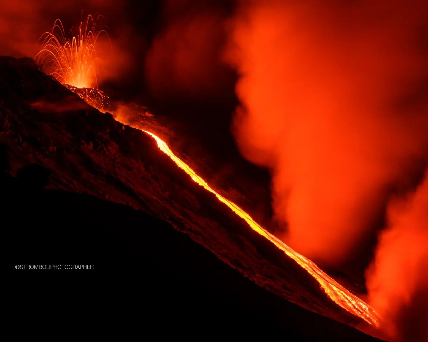
In the Center-South zone (CS) an explosive activity of medium intensity was observed (the products did not exceed 150 in height) emitting coarse materials mixed with fine materials (ash). The frequency varied from less than 1 to 7 events/h. It should be noted that until January 27, the frequency was 6-7 events/h, then, in the following two days, it decreased to less than 1 event/h.
January 24, 2023 lava overflow.
At 14:19 UTC on January 24, preceded by intense spattering activity from the mouths of the N2 sector, the northern sector of the crater area was affected by the appearance of an overflow of lava which began to flow abundantly in the upper part of the Fire Sciara. On the morning of January 25, 2023, the lava flow was cooling.
Source : INGV.
Photos : Stromboli stati d’animo / Sebastiano Cannavo.
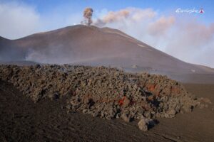
Italy / Sicily , Etna :
WEEKLY BULLETIN, from January 23, 2023 to January 29, 2023. (issue date January 31, 2023).
ACTIVITY STATUS SUMMARY
In the light of the monitoring data, it is highlighted:
1) VOLCANOLOGICAL OBSERVATIONS: Effusive activity with lava flows in the Valley del Leone, variable rate degassing of the summit craters associated with modest and sporadic ash emissions from the Southeast crater.
2) SEISMOLOGY: Very weak seismic activity of fracturing; average amplitude of the volcanic tremor in the average level.
3) INFRASOUND: Weak infrasonic activity.

Map of the lava field updated on January 29, 2023 and made by analyzing Landat 8-9 satellite images from January 23 and Sentinel 2 from January 27 and 29. The background image is the shaded model of the relief of the summit area of Etna, obtained by processing drone images acquired during several overflights (September 15 and 21, 2022, October 6, 21 and 23), superimposed on the shaded model derived from Pléiades images of August 22, 2020 (AO Remote Sensing). CSE = South Crater
4) GROUND DEFORMATIONS: The ground deformation monitoring networks did not measure any significant variations during the last week.
5) GEOCHEMISTRY: SO2 flux at an average level
The soil CO2 flux values recorded last week are medium to low values.
The CO2 in groundwater (EtnaAcque Network) does not show variations apart from the seasonal variability of the site.
6) SATELLITE OBSERVATIONS: The thermal activity observed by satellite in the summit zone was of a high level in correspondence with the effusive eruption in the summit zone.
VOLCANOLOGICAL OBSERVATIONS
During the week, monitoring of Etna’s activity was carried out through the surveillance cameras of the INGV – Osservatorio Etneo.
During the week in question, modest effusive activity continued, with no substantial changes from the previous week, which began on November 27, 2022, from the vent that opened at Base Nord- East of the Southeast crater at an altitude of about 2800 m which produces the overlap of lava flows in the Valle del Leone area and on the west wall of Valle del Bove. The development of the lava field in the interval January 16-23 is shown in Fig. 1.
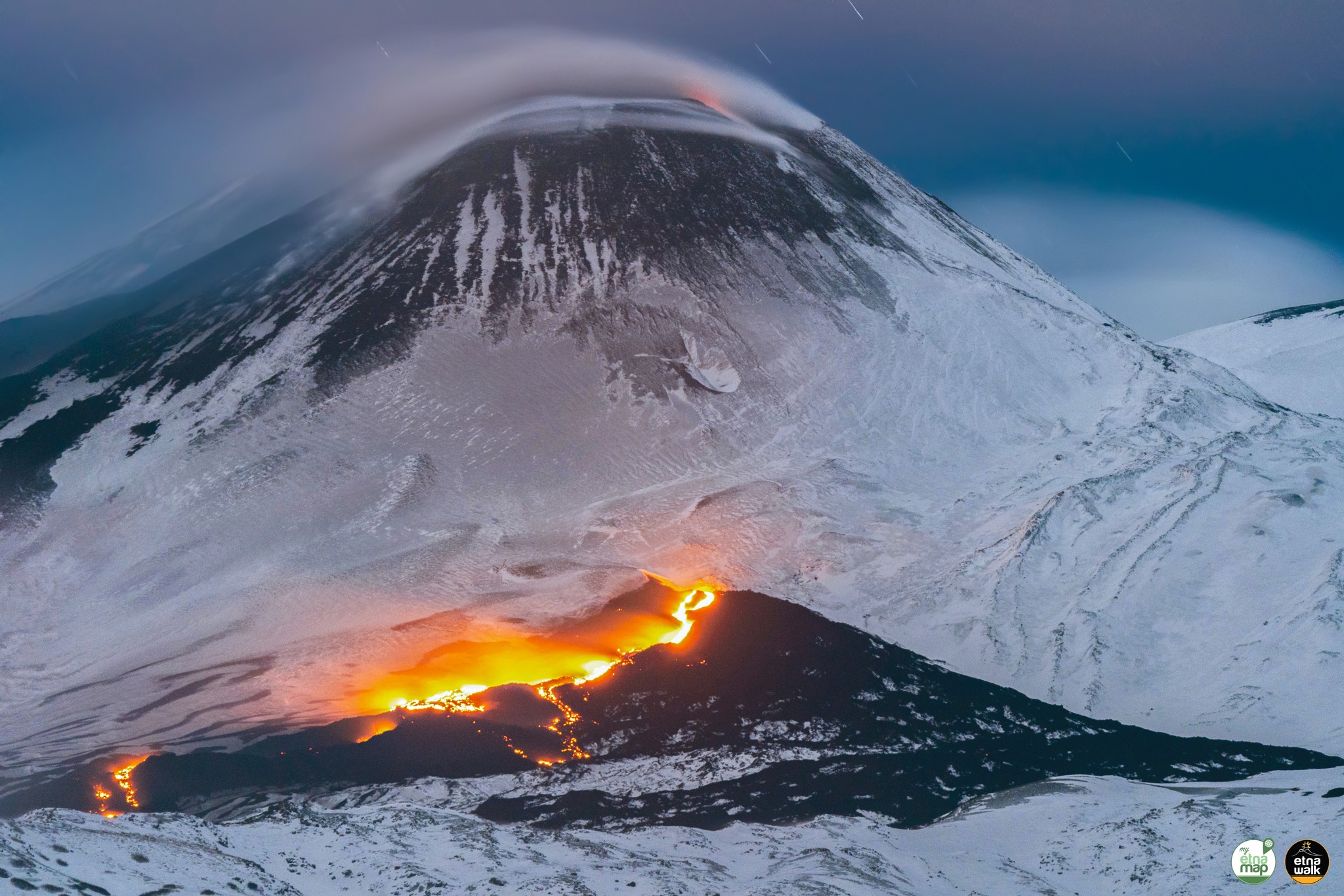
During the week under review, the most advanced fronts of the lava field remain confined to an altitude between approximately 2450 and 2050 m and, in particular, at an altitude of 2450 m on January 29. The area covered from November 27, 2022 to January 29, 2023 is equal to 8.8 x 10^5 m2 and the total volume is between 4.4 and 5.6 x10^6 m3. This estimate is preliminary and an error of approximately 40% is estimated.
Summit crater activity was characterized by variable rate degassing, primarily affecting the Bocca Nuova crater where intense impulsive degassing continued; while the degassing of the Northeast Crater and the Voragine crater remained, on the other hand, extremely mild.
The Southeast crater was characterized by fumarolic degassing, mainly located along the crater rim, and by May-June 2022 eruptive degassing that occasionally showed nocturnal eruptions. This vent was affected by modest dilute ash emissions that high altitude winds quickly dispersed to the summit area.
Source : INGV.
Photos : INGV , Etna walk Marco Restivo / Guiseppe Distefano
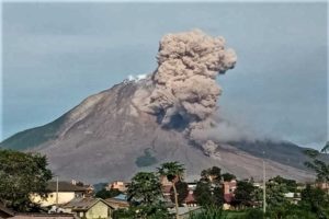
Russia / Kuril Islands , Chikurachki :
VOLCANO OBSERVATORY NOTICE FOR AVIATION (VONA)
Issued: February 01 , 2023
Volcano: Chikurachki (CAVW #290360)
Current aviation colour code: ORANGE
Previous aviation colour code: orange
Source: KVERT
Notice Number: 2023-19
Volcano Location: N 50 deg 19 min E 155 deg 27 min
Area: Northern Kuriles, Russia
Summit Elevation: 1816 m (5956.48 ft)
Volcanic Activity Summary:
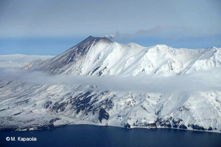
An eruptive activity of the volcano continues. Satellite data showed an ash plume extended about 50 km to the north-east of the volcano.
An activity of the volcano continues. Ash explosions up to 6 km (19,700 ft) a.s.l. could occur at any time. Ongoing activity could affect low-flying aircraft.
Volcanic cloud height:
3200-3500 m (10496-11480 ft) AMSL Time and method of ash plume/cloud height determination: 20230201/0022Z – MODIS TERRA 31m32
Other volcanic cloud information:
Distance of ash plume/cloud of the volcano: 50 km (31 mi)
Direction of drift of ash plume/cloud of the volcano: NE / azimuth 52 deg
Time and method of ash plume/cloud determination: 20230201/0022Z – MODIS TERRA 31m32
Source : Kvert
Photo : M. Karasev
Chile , Lascar :
Special Report on Volcanic Activity (REAV), Antofagasta Region, Láscar Volcano, January 31, 2023, 3:00 p.m. local time (mainland Chile)
The National Geology and Mining Service of Chile (Sernageomin) announces the following information obtained through the monitoring equipment of the National Volcanic Monitoring Network (RNVV), processed and analyzed at the Observatory of Volcanoes of the Southern Andes (Ovdas ):
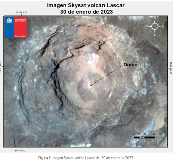
On Tuesday January 31, 2023 at 3:00 p.m. (6:00 p.m. UTC) we inform of the appearance of a dome-type effusive body inside the crater of the Lascar volcano, with a diameter of 81 m (minimum measurement) and 93 m (maximum measurement) with an area of 5332 m2, detected from a Skysat Collect image.
Seismic activity:
Over the past 24 hours, the seismic record from Lascar Volcano continues its downward trend, both in quantity and magnitude. However, during the last days, the seismicity of the fluids presents characteristics in their signals with monochromatic trends in their frequencies, while the appearance of the Tornillo type seismicity on January 30 is associated with the interaction with the clogging at the within the system.
Exposure / Specific risk
The potential impacts associated with the presence of a lava dome inside the active crater derive from its possible total or partial destruction, by an event with explosive characteristics. In this scenario, the occurrence of pyroclastic flows and ballistic pyroclastic ejections in the current area is expected.
Hazards
The assignment by ash fall outside the zoning radius is not excluded, which could occur, preferentially, in the West.
Source : Sernageomin .
Photo : Skysat.