January 19 , 2023 .
Hawaii , Kilauea :
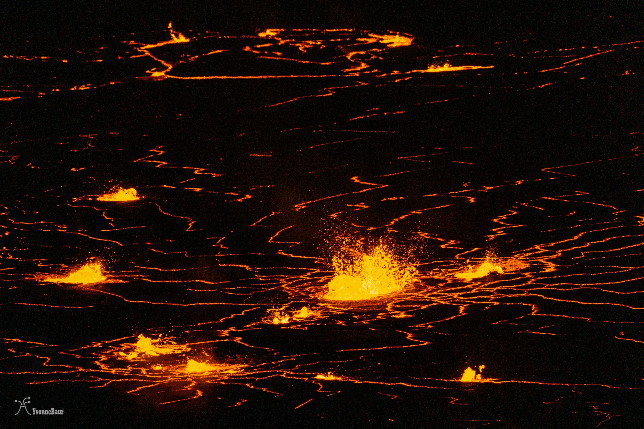
HVO reported that lava continued to erupt from vents on the central E portion of Kilauea’s Halema’uma’u Crater floor during 10-17 January. Activity was concentrated in a large lava lake, covering about 12 hectares in the E half of the crater on 10 January. One dominant lava fountain, 6-7 m high, was active within this area. Lava flows built up the margins of the lake, causing the lake to be perched; small overflows along the margins were visible during 13-16 January. A smaller area of lava was active within the basin in the W half of the crater that had been the focus of activity during 2021-2022. The Volcano Alert Level remained at Watch (the second highest level on a four-level scale) and the Aviation Color Code remained at Orange (the second highest level on a four-color scale).
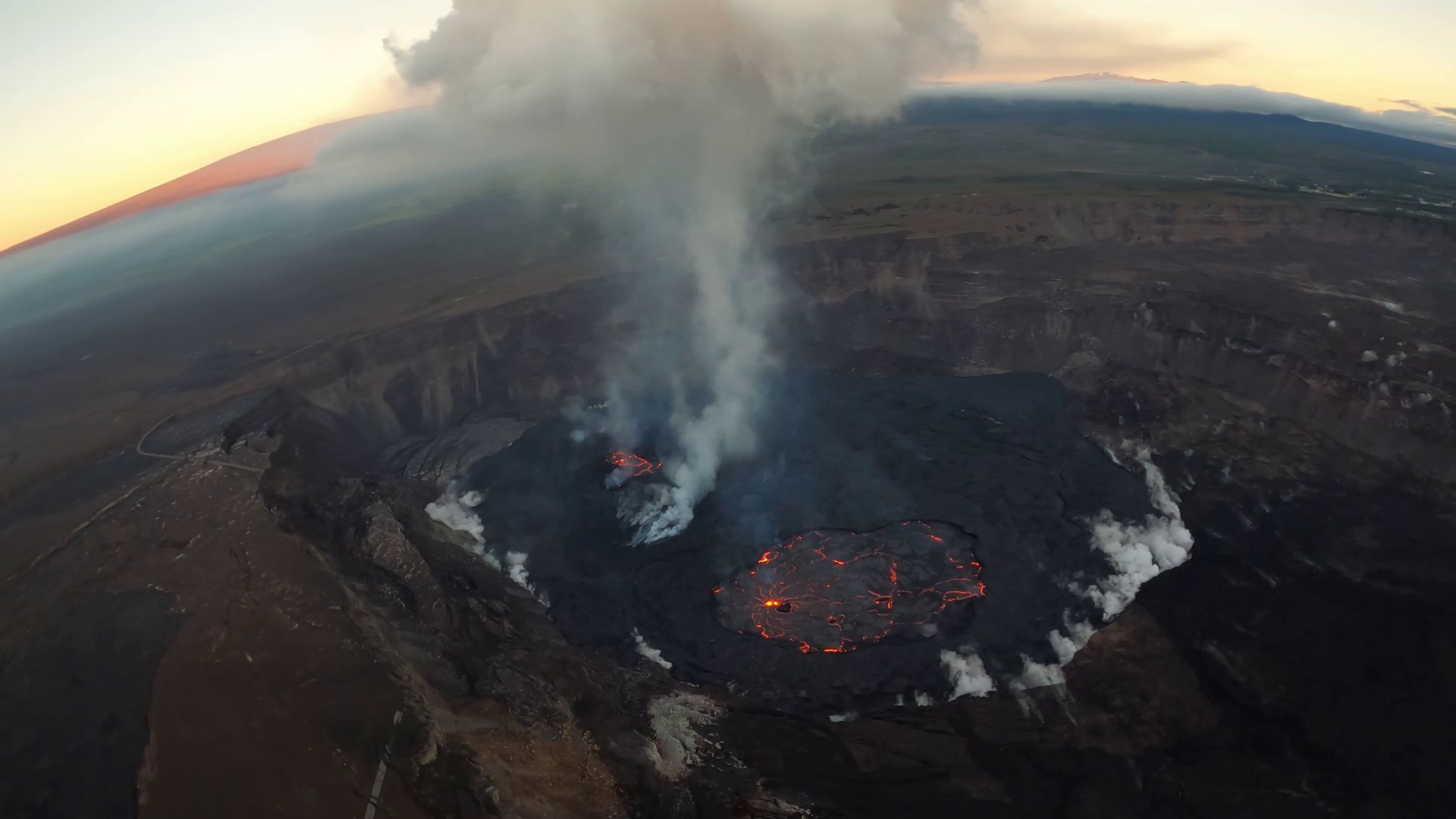
The eruption in Halema‘uma‘u crater, at the summit of Kīlauea, continues with steady lava lake activity. The largest lake is in the eastern portion of the crater, and is supplied by a single fountain. A smaller lake is also active in the western portion of the crater, along with two other much smaller lakes
Wednesday, January 18, 2023, 8:46 AM HST (Wednesday, January 18, 2023, 18:46 UTC)
19°25’16 » N 155°17’13 » W,
Summit Elevation 4091 ft (1247 m)
Current Volcano Alert Level: WATCH
Current Aviation Color Code: ORANGE
Activity Summary:
The summit eruption of Kīlauea Volcano, within Halemaʻumaʻu crater, continued over the past 24 hours. All recent eruptive activity has been confined to the crater. No significant changes have been observed at the summit or in either rift zone.
Halemaʻumaʻu Lava Lake Observations:
Eruption of lava in the eastern portion of Halemaʻumaʻu crater floor continued over the past 24 hours. Activity is concentrated in a large lava lake in the eastern half of the crater, as well as a smaller lake to the west, in the basin of the 2021–2022 lava lake. The eastern lava lake has one dominant fountain, measured at 6-7 meters (yards) high and an area of approximately 30 acres (12 hectares) as of January 10. The surface area did not change much over the past 24 hours, though a series of short-lived overflows occurred onto the crater floor yesterday evening.
Summit Observations:
Summit tiltmeters showed inflationary tilt early yesterday, consistent with the inflation phase of a summit Deflation-Inflation (DI) event. No significant tilt has been recorded over the past 12 hours. Volcanic tremor remains above background levels. A sulfur dioxide (SO2) emission rate of approximately 3,500 tonnes per day (t/d) was measured on January 9, 2023.
Photos : USGS / M. Patrick , Yvonne Baur .
Chile , Villarica :
Special Report on Volcanic Activity (REAV), La Araucanía and Los Ríos regions, Villarrica volcano, January 18, 2023, 1:15 p.m. local time (mainland Chile)
The National Geology and Mining Service of Chile (Sernageomin) announces the following PRELIMINARY information, obtained through the monitoring equipment of the National Volcanic Monitoring Network (RNVV), processed and analyzed at the Observatory of Volcanoes of the Southern Andes (Ovdas):
On Wednesday, January 18, 2023, at 09:58 local time (12:58 UTC), monitoring stations installed near the Villarrica volcano recorded an earthquake associated with fluid dynamics within the volcanic system. (type LP).

The characteristics of the earthquake, after its analysis, are as follows:
ORIGINAL TIME: 09:58 local time (12:58 UTC)
REDUCED DISPLACEMENT: 71.21 (cm*cm)
ACOUSTIC SIGNAL: 7.5 Pascals (Pa) reduced to 1 km
The characteristics of this activity are as follows:
MAXIMUM HEIGHT OF THE COLUMN: 60 meters above the point of emission
DIRECTION OF DISPERSION: Southwest (SW).
COMMENTS:
Following the issuance of this report, surface activity continues with low-level white degassing and seismic activity similar to previous days.
The volcanic technical alert is maintained at the Yellow level.
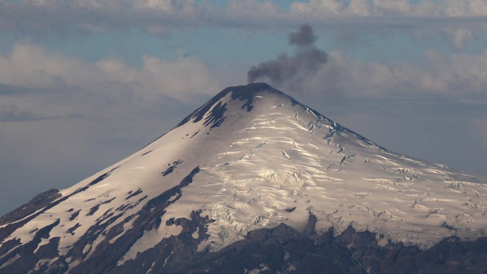
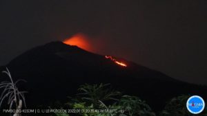
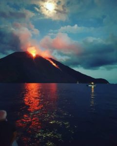
SERNAGEOMIN reported that the eruption at Villarrica was ongoing during 11-17 January. Strombolian explosions and lava fountaining from the vent on the crater floor were frequently visible in webcam images. Explosions during 11-12 January ejected material 80 m high and as far as 250 m onto the NE flank. The number of explosions increased during 14-15 January, some ejecting material up to 150 m above the crater rim. POVI scientists counted about 70 instances of lava fountaining from 2130 on 14 January to 0600 on 15 January. Material ejected by the explosions stayed within or near the crater during 16-17 January. The Alert Level remained at Yellow (the second lowest level on a four-color scale). ONEMI maintained the Alert Level at Yellow (the middle level on a three-color scale) for the municipalities of Villarrica, Pucón (16 km N), Curarrehue, and the commune of Panguipulli.
Sources : Servicio Nacional de Geología y Minería (SERNAGEOMIN), Oficina Nacional de Emergencia-Ministerio del Interior (ONEMI), Proyecto Observación Villarrica Internet (POVI) , GVP.
Photos : Sernageomin , 24 horas
Japan , Sakurajima :
JMA reported ongoing eruptive activity at Minamidake Crater (at Aira Caldera’s Sakurajima volcano) during 9-16 January. Crater incandescence was visible nightly. Eruptive events at 0210 on 9 January and 1837 on 14 January produced plumes that rose 1 km above the crater rim. Sulfur dioxide emissions were high at 2,100 tons per day on 13 January. The Alert Level remained at 3 (on a 5-level scale), and residents were warned to stay 2 km away from the crater.
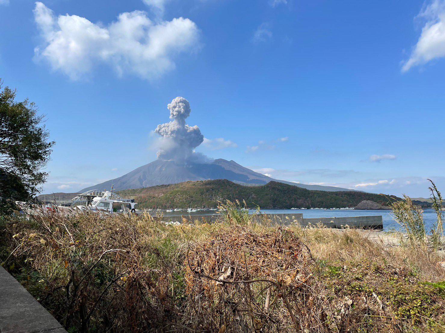
The Aira caldera in the northern half of Kagoshima Bay contains the post-caldera Sakurajima volcano, one of Japan’s most active. Eruption of the voluminous Ito pyroclastic flow accompanied formation of the 17 x 23 km caldera about 22,000 years ago. The smaller Wakamiko caldera was formed during the early Holocene in the NE corner of the Aira caldera, along with several post-caldera cones. The construction of Sakurajima began about 13,000 years ago on the southern rim of Aira caldera and built an island that was finally joined to the Osumi Peninsula during the major explosive and effusive eruption of 1914. Activity at the Kitadake summit cone ended about 4850 years ago, after which eruptions took place at Minamidake. Frequent historical eruptions, recorded since the 8th century, have deposited ash on Kagoshima, one of Kyushu’s largest cities, located across Kagoshima Bay only 8 km from the summit. The largest historical eruption took place during 1471-76.
Source : : Japan Meteorological Agency (JMA) , GVP.
Photo : @walksamurai via Patrice Zwenger
Kamchatka , Sheveluch :
VOLCANO OBSERVATORY NOTICE FOR AVIATION (VONA)
Issued: January 19 , 2023
Volcano: Sheveluch (CAVW #300270)
Current aviation colour code: ORANGE
Previous aviation colour code: red
Source: KVERT
Notice Number: 2023-11
Volcano Location: N 56 deg 38 min E 161 deg 18 min
Area: Kamchatka, Russia
Summit Elevation: 3283 m (10768.24 ft), the dome elevation ~2500 m (8200 ft
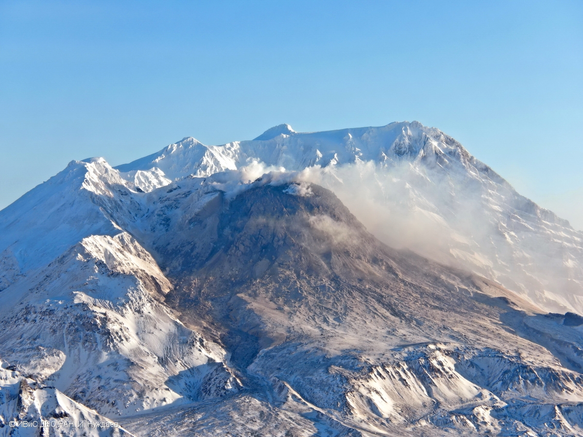
Volcanic Activity Summary:
The growth of the lava dome continues, a strong fumarole activity, an incandescence of the lava dome, explosions, and hot avalanches accompanies this process. There are not observing ash clouds and ash plumes near Sheveluch volcano at now. KVERT continues to monitor the volcano.
Current aviation colour code: ORANGE
Previous aviation colour code: red
The extrusive eruption of the volcano continues. Ash explosions up to 10-15 km (32,800-49,200 ft) a.s.l. could occur at any time. Ongoing activity could affect international and low-flying aircraft.
Volcanic cloud height: NO ASH CLOUD PRODUSED
Other volcanic cloud information: NO ASH CLOUD PRODUSED
Source : Kvert.
Photo : I. Nuzhdaev, IVS FEB RAS.
Ecuador , Cotopaxi :
IG reported that the eruption at Cotopaxi continued during 11-17 January, characterized by daily steam-and-gas emissions often with variable content. On 11 January ash plumes rose as high as 200 m above the crater rim and drifted W and SW. Minor ashfall was noted in areas of Mulaló, Macaló Grande, San Antonio, San Ramón (127 km W), Ticatilín (15 km SW), and MAE Norte (18 km N), and a sulfur odor was noted in Ticatilín and Control Caspi (20 km WSW) of the Parque Nacional Cotopaxi. On 12 January steam, gas, and ash plumes rose as high as 1 km and drifted SE, SW, and W. On 13 January a dense ash plume rose 2 km and drifted NE, causing ashfall in Ticatilín; other ash plumes rose 1 km and drifted W and N that same day. Steam-and-gas emissions rose 300-700 m during 14-17 January and drifted E, SE, and SW. Ash-and-gas plumes rose 1 km on 17 January and drifted W and SW; minor ashfall was reported in Mulaló and San Juan de Pastocalle (20 km WSW). Servicio Nacional de Gestión de Riesgos y Emergencias (SNGRE) maintained the Alert Level at Yellow (the second lowest level on a four-color scale).

DAILY REPORT OF THE STATE OF COTOPAXI VOLCANO, Wednesday January 18, 2023.
Information Geophysical Institute – EPN.
Surface activity level: Moderate, Surface trend: Ascending.
Internal activity level: Moderate, Internal trend: No change.
Seismicity: From January 17, 2023, 11:00 a.m. to January 18, 2023, 11:00 a.m.:
The volcano’s seismic array remained operational for the past 24 hours.
Emission Tremor (TREMI) 43
Long Period (LP): 56
Rains / Lahars:
In the afternoon of yesterday, there were rains in the area of the volcano.
Emission / Ash Column:
During the last 24 hours, several emissions of gas and ash have been observed with heights between 1,000 and 2,000 meters above the level of the crater. Said emissions maintained a West-South-West direction yesterday, and an East-North-East direction today. The Washington VAAC has issued 3 reports associated with the ash emission observed through satellite monitoring, the maximum height of which corresponds to 800 meters above the level of the crater in a southwest direction.
Observation:
During the night of yesterday and early today, the volcano was clear and a slight continuous emission of gas and ash was observed above the level of the crater. Until the closing of this bulletin, ash falls were reported in the sectors of the locality of Aláquez: Chillos, Langualó, San Isidro Alto, and in the locality of Mulaló in the sectors: San Agustín del Callo, in the province of Cotopaxi.
Alert level: Yellow.
Source : IGEPN , GVP. Instituto Geofísico-Escuela Politécnica Nacional (IG), Servicio Nacional de Gestión de Riesgos y Emergencias (SNGRE)
Photo : IGEPN