July 07 , 2018.
Vanuatu , Ambae :
VANUATU VOLCANO ALERT BULLETIN N°5 – AMBAE ACTIVITY
Thursday June 7th 2018
15°24’0”S 167°50’0”E Summit 4908ft (1496m)
Current Vanuatu Volcano Alert Level: Level 2
Ambae volcano is in the major unrest state. The Volcanic Alert Level is lowered to Level 2 .
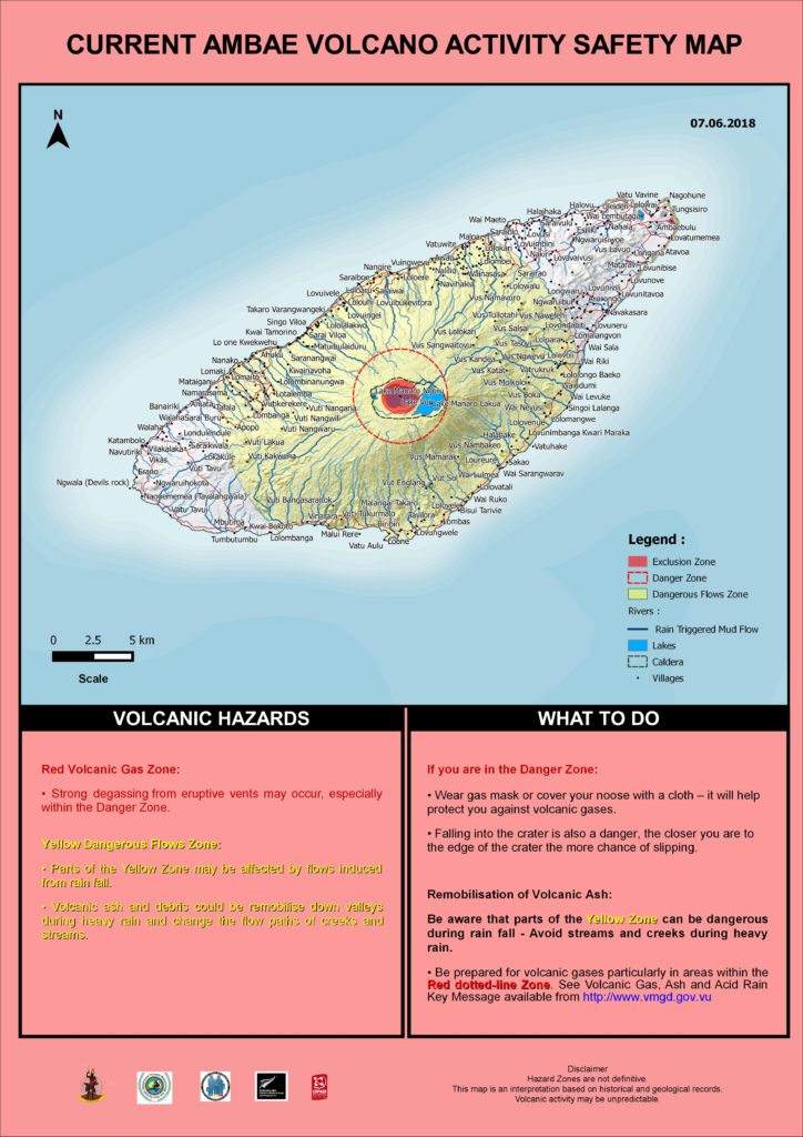
Ambae volcano activity becomes stable. The current volcanic activity is consistent with Volcanic Alert Level 2. The Danger Zone for life safety is now limited at 2 km radius from the active vent and areas located in the Yellow Zone (See Map below).
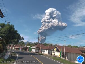
Observations in May 2018 confirm that the eruptive activity occurred in March until April has dropped. There is no explosions and volcanic cloud emitted are white color, means only steam. A small scale eruption in Lake Voui has ceased.
The presence of ash that has fallen on Ambae during the last eruption will continue to change the behavior of streams and creeks when it rains. The creeks and streams can produce floods and carry a lot more debris (sands, gravel and boulders). The flow path of streams and creeks could change due to the flood debris. Landslide may occur at some areas during heavy rain fall.
These observations and the analysis of seismic data confirm that the volcano activity is in the major unrest state. The volcano activity consist of ongoing emission of steam and/or volcanic gases.
The local population and visitors can smell the volcanic gas while approaching the volcano.
Significant impact of ashes and gases emission to villages at Ambae started in March, when the Volcanic Alert level was raised to Level 3. Observations of the current activity are consistent with the Alert Level 2 activity. Level 2 indicates ‘Major unrest; Danger is now at 2 km around the volcanic vents and areas inside the Yellow Zone’ . The possibility that the Ambae volcano activity escalate to the level of minor eruption is moderate to low .
Ambae volcano is a very large volcano and is frequently active. A large-scale eruption about 400 years ago built a volcanic cone in the summit crater and the crater is now filled by Lake Voui; the modern active vent area underlies Lake Voui. Historic activity is poorly known, but there is documented activity in 1530, 1670, 1870, 1915 and 1966. All documented activity has been from the summit crater (Lake Voui) except for the 1670 activity, which included a flank eruption producing lava flows at Ndui Ndui. The current eruption episode started in 1991, with eruptions in 1995, 2005, 2016 and 2017. The current eruption is focused in the summit crater and there are no indications of activity elsewhere on Ambae Island for now
Source : Geohazard Vanuatu.
Hawai , Kilauea :
Friday, July 6, 2018, 11:25 AM HST (Friday, July 6, 2018, 21:25 UTC)
19°25’16 » N 155°17’13 » W,
Summit Elevation 4091 ft (1247 m)
Current Volcano Alert Level: WARNING
Current Aviation Color Code: ORANGE
Kīlauea Volcano Lower East Rift Zone
The eruption in the lower East Rift Zone (LERZ) continues with no significant change during the past 24 hours.
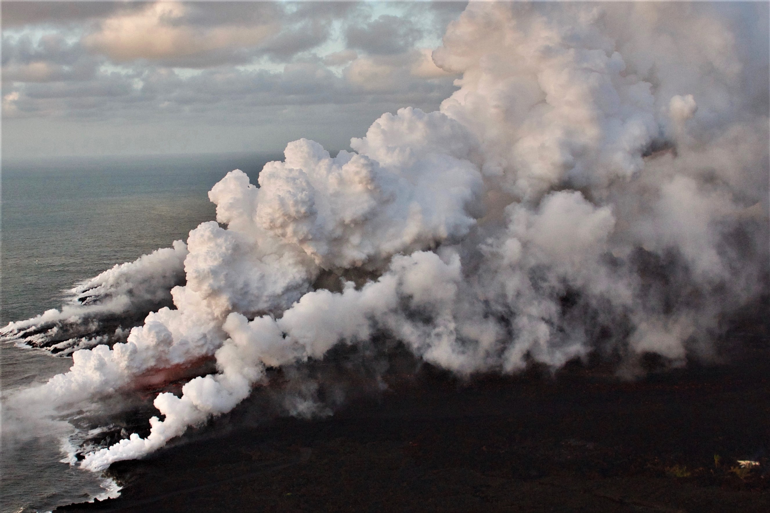
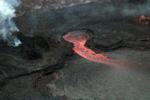
Fountains from Fissure 8 spatter cone continue to supply lava to the open channel with intermittent small, short-lived overflows. The spatter cone is now about 55 m (180 ft) tall at its highest point, and fountains rarely rise above that point. As shown by the July 02 thermal map of the flow field, the main lava channel no longer reaches the coast, the channel flow seems to stall about 0.8 km (0.5 mi) inland of the coast; however, lava is oozing into the ocean from multiple points primarily along the northern section of a broad flow front.
Lava enters the sea along the Kapoho coastline, building a delta that is now over 555 acres in size.
The large flow active over the past 48 hours from multiple ooze-outs along the northern edge of the flow continued to be active between Kapoho Crater and the ocean and continued to be the dominant ocean entry and laze plume this morning.
Fissure 22 is still weakly spattering this morning with a weak flow extending east.
https://www.facebook.com/dane.dupont.731/videos/166720697530413/
Kīlauea Volcano Summit
Another collapse explosion event occurred 1:20 PM HST on July 5 at Kīlauea’s summit. Seismicity dropped abruptly for several hours afterwards, but has since returned to 25-35 earthquakes per hour, a number of which are in the magnitude 2-3 range. Another collapse explosion is expected later today. Inward slumping of the rim and walls of Halemaʻumaʻu continues in response to ongoing subsidence at the summit.
Sulfur dioxide emissions from the volcano’s summit have dropped to levels that are about half those measured prior to the onset of the current episode of eruptive activity. This gas and minor amounts of ash are being transported downwind, with small bursts of ash and gas accompanying intermittent explosive activity.
Source : HVO
Photo : USGS
Video : Hawaii County Civil Defense / Dane DuPont
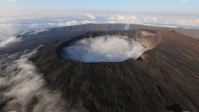
La Réunion , Piton de la Fournaise :
News bulletin of Friday, July 6, 2018 at 15:00 (local time).
Since the beginning of July, inflation (swelling) of the Piton de la Fournaise building has been observed again by the OVPF deformation network.
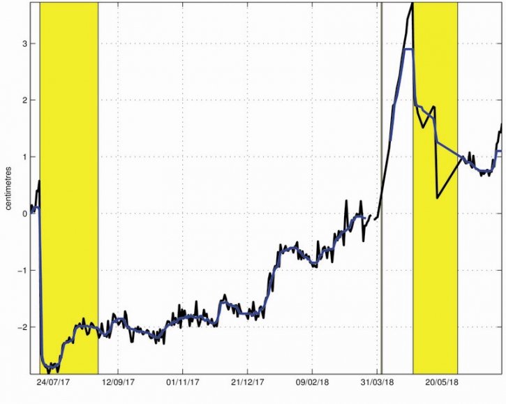
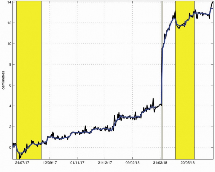
Thus since July 1st a 0.5-1 cm elongation of the summit zone (Figure 1) and a 0.5-1.2 cm elongation of the base of the terminal cone (Figure 2) are recorded.
Figure 1: Illustration of the deformation during the last twelve months (the eruptions of July 14-August 28, 2017, April 3-4, 2018 and April 27-June 1, 2018 are shown in yellow). Here is shown a baseline (distance between two GPS receivers) crossing the Dolomieu crater from north to south (in black the raw data, in blue the data smoothed over a week). A rise is synonymous with elongation and therefore swelling of the volcano; conversely, a decrease is synonymous with contraction and therefore deflation of the volcano. (© OVPF / IPGP)
Figure 2: Illustration of deformation over the past 12 months (eruptions from July 14-August 28, 2017, April 3-4, 2018 and April 27-June 1, 2018 are shown in yellow). Here is shown a baseline (distance between two GPS receivers) crossing the terminal cone from north to south (in black the raw data, in blue the data smoothed over a week). A rise is synonymous with elongation and therefore swelling of the volcano; conversely, a decrease is synonymous with contraction and therefore deflation of the volcano. (© OVPF / IPGP)
This recovery in the inflation of the building is synonymous with a pressurization of the superficial magmatic reservoir by a deep recharge in magma. The high CO2 concentrations in the far-field soil (Plaine des Cafres and Plaine des Palmistes areas), which have been maintained since the end of the eruption on June 1st, are in agreement with a deep rise of magma.
The change in trend observed in the deformations of the building (resumption of inflation) since July 1st attests to a possible transfer to lower depths (superficial reservoir). Note that for the eruption of April 27 – June 1, 2018, this phase of pressurization lasted about three weeks (April 4-27, 2018) before the roof of the tank becomes fragile and breaks, giving rise to a magma injection to the surface and a rash.
Source : OVPF
Chile , Planchon Peteroa :
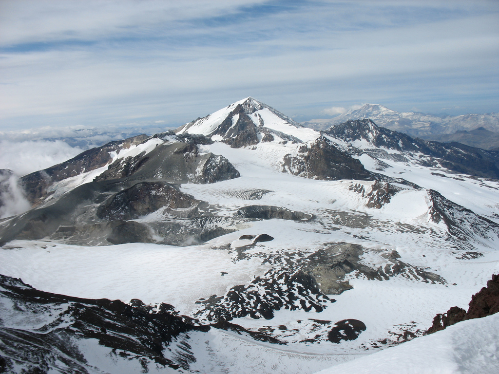
During this period, 390 seismic events were recorded, of which 47 were classified as being of the volcano-tectonic (VT) type associated with rock fracturing processes, with maximum local magnitudes of M 1.3, corresponding to one events located 1km northwest of the active crater and at a depth of 4.5km.
In addition, three hundred and twenty-nine (329) long-period (LP) earthquakes, related to the dynamics of fluids within the volcanic system, the largest of them with a small displacement (DRC) 22 cm were recorded. The location of these events shows a concentration in the crater area and slightly eastward with shallow depths (2.5-3.5 km)
Since the beginning of 2016, there has been an increase in continuous tremor amplitude at a low rate, which has increased in mid-May to reach reduced maximum displacement values of up to 5 cm2 and an average value of of 3 cm2, values considered moderate / low. A peculiarity of this signal in the last days is its amplitude oscillatory character with periodic increases and decreases, commonly known as « band tremor ». Its spectral content dominates between 1 and 2 Hz. The estimate of its location indicates an origin of greater depth (about 4.5 km) located east of the active crater zone.
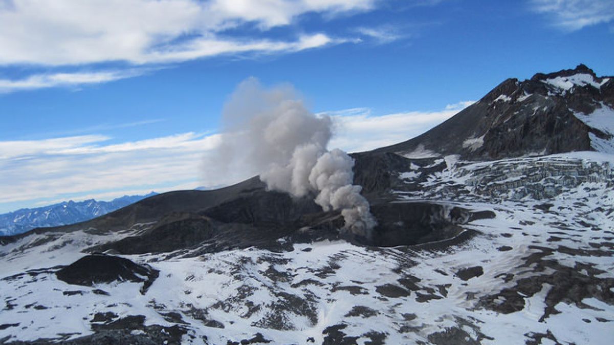
The images provided by the IP camera show persistent, low-energy, whitish-colored degassing with column heights no greater than 500 m above the level of the currently active crater. On June 21 at 13:03, a tremor signal was recorded with a more open spectrum and a dominant frequency around 5 Hz and a reduced displacement of 4 cm2 that was directly related to a small gas emission (puff) in the active crater
From the data obtained by three (3) GNSS stations, which measure the deformation in the volcanic complex, no significant deformation was observed. On the other hand, the data recorded by the inclinometers installed near the volcanic complex, do not present variations related to the evolution of the internal dynamics of the volcano.
No anomalies were reported in sulfur dioxide (SO 2) emissions to the atmosphere in the volcanic complex sector, according to data obtained by the Ozone Monitoring Instrument (OMI) Group Sulfur Dioxide (O2). http: //so2.gsfc.nasa .gov /) and the National Service for the Environment, Data and Satellites (NESDIS) (http://satepsanone.nesdis.noaa.gov).
No thermal alerts have been reported in the area associated with the volcanic complex according to data published by Middle Observation InfraRed of Volcanic Activity (Mirova) on its website (http://www.mirovaweb.it/),
The increase in tremor amplitude suggests that the contribution of the heat of an intrusive magmatic body to the shallow layers, expressed by the VT seismicity recorded since 2016, interacts more directly with the hydrothermal system both deep and shallow, as confirmed by the correlation « puff » mentioned and the seismic signal. It is suggested by the recording of the « band tremor » which had a precursor character of phreatic eruptions on other volcanoes with extended hydrothermal systems, the presence of a sample of a certain type of instability in the system .
In this scenario, there is a greater chance of minor explosive activity of phreatic nature, so the volcanic alert is changed to:
YELLOW LEVEL: Changes in the behavior of volcanic activity – Probable time for an eruption: WEEKS / MONTH.
Observations: The current area of assignment is considered to be within 500 meters of the active crater area.
On Friday, the Onemi declared the yellow alert for 4 municipalities in the Maule region due to the detection of a change in the activity of the Planchón-Peteroa volcanic complex.
According to information from Ovdas – Sernageomin, the volcano is above its base threshold and the process is unstable.
As a result, they believe that it may still evolve, increase or decrease its activity levels. They also predict that a rash is likely over a period of weeks or months.
The alert, which concerns the municipalities of Molina, Curicó, Romeral and Teno, will be valid from this Friday until the conditions justify its modification.
Source : Sernageomin , Biobiochile .
Photos : Sernageomin


