September 9 , 2025.
Indonesia , Dukono :
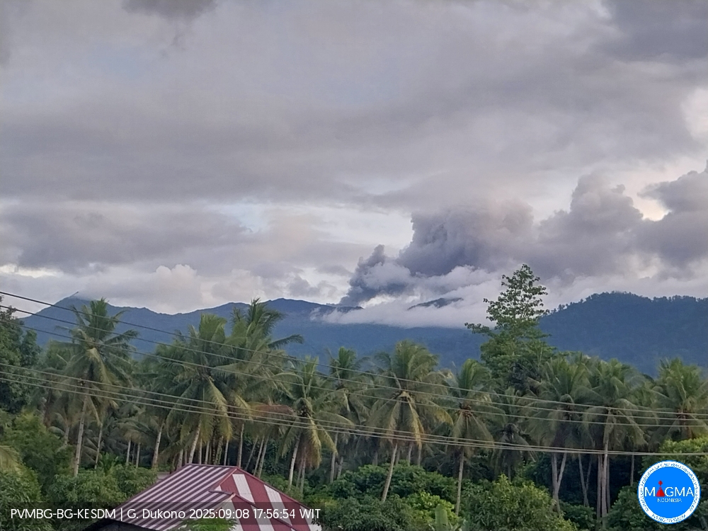
Mount Dukono erupted on Monday, September 8, 2025, at 5:54 PM (local time). An ash column was observed about 400 m above the summit (about 1,487 m above sea level). The ash column was white to gray in color, with moderate intensity, oriented northwest. At the time of writing, the eruption was still ongoing.
Seismic Observations
11 eruption earthquakes with amplitudes of 6 to 10 mm and durations of 45.47 to 85.22 seconds.
3 distant tectonic earthquakes with amplitudes of 10 to 34 mm and durations of 61.72 to 104.41 seconds.
1 continuous tremor with amplitudes of 1 to 5 mm, mainly 2 mm.
Recommendations
(1) Residents living around Mount Dukono and visitors/tourists are advised to refrain from all activities, climbing, and approaching the Malupang Warirang crater within a 4 km radius.
(2) Since volcanic ash eruptions occur periodically and the distribution of ash follows the direction and speed of the wind, making the ash coverage area unstable, it is recommended that communities around Mount Dukono always have masks/nose and mouth coverings available for use when needed to avoid the dangers of volcanic ash on the respiratory system.
Source et photo : Magma Indonésie .
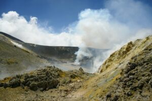
Canary Islands , Tenerife :
In August, 213 earthquakes occurred in the Canary Islands, with a maximum magnitude of 2.9, and two seismic swarms were observed beneath Mount Teide.
In the area between the islands of Gran Canaria and Tenerife, where the Enmedio underwater volcano is located, 57 earthquakes with an epicenter at sea were recorded.
The National Geographic Institute (IGN) has published, as it does every month, the total number of earthquakes recorded by its seismic network in the Canary Islands. This time, the figure stands at 213, compared to 125 the previous month. None of them were felt by the population. The maximum recorded magnitude, 2.9 (mbLg), corresponds to an earthquake with an epicenter at sea, approximately 20 kilometers east of the island of Gran Canaria. The IGN goes on to state that most of the seismic activity occurred inland on the island of Tenerife, where 122 earthquakes with magnitudes between -0.3 and 1.8 (mbLg) were detected. Two swarms of micro-seismic activity were noted on this island throughout the month. The first began at 2:00 a.m. (UTC) on August 7 in the Las Cañadas del Teide region, southwest of Pico Viejo, and was active for more than three hours, during which more than 700 very low-magnitude events were detected.

The second swarm of activity occurred on August 30 between 4:20 PM (UTC) and 5:30 PM (UTC), with a total of 42 detections in the same epicentral area. Nineteen events were detected at depths of approximately 5 kilometers below sea level. The maximum magnitude recorded in this swarm was 0.8 (mbLg).
In the area between the islands of Gran Canaria and Tenerife, where the Enmedio submarine volcano is located, 57 earthquakes with epicenters at sea were recorded, with magnitudes between 1.0 and 2.3 (mbLg) and a maximum depth of 71 kilometers.
On the island of La Palma, 13 earthquakes were located, with magnitudes between 1.1 and 1.9 (mbLg) and a maximum depth of 17 kilometers. Most of them are located around the lava flows from the 2021 eruption and in the central part of Cumbre Vieja.
Source : El Diario . es
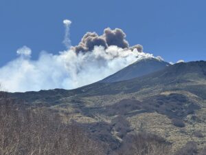
Photo : pico viejo , real-estate-tenerife.eu
Hawaii , Kilauea :
HAWAIIAN VOLCANO OBSERVATORY DAILY UPDATE , U.S. Geological Survey
Monday, September 8, 2025, 7:59 AM HST (Monday, September 8, 2025, 17:59 UTC)
19°25’16 » N 155°17’13 » W,
Summit Elevation 4091 ft (1247 m)
Current Volcano Alert Level: WATCH
Current Aviation Color Code: ORANGE
Activity Summary:
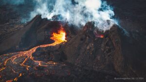
Episode 32 of the ongoing Halemaʻumaʻu eruption ended abruptly at 8:01 p.m. HST on September 2 after 13.4 hours of continuous fountaining. Models suggest episode 33 will start September 18 or later.
Summit Observations:
Lava flows from episode 32 covered 40-50% of the floor of Halemaʻumaʻu within the southern part of Kaluapele (Kīlauea caldera).
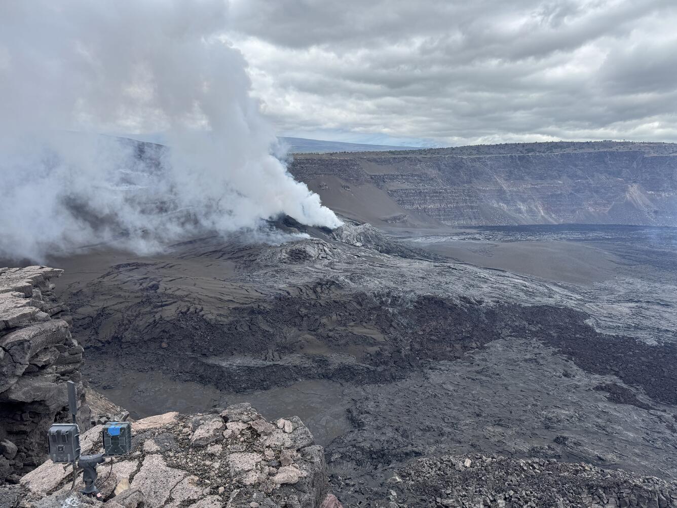
This view is from the south rim of the summit caldera on Kīlauea and shows the vent complex formed during the ongoing eruption. The vent area consists of overlapping lobes of spatter-fed flows, layers of tephra, and thin fluid lava flows. Much of the rubbly material in the central portion of the photo originates from « spatter-fed » flows, which forms as hot spatter from the lava fountains piles up around the vents, and then coalesces to form a very viscous type of secondary lava flow.
The Uēkahuna tiltmeter (UWD) recorded about 25 microradians of deflationary tilt during this episode. The end of the eruption was coincident with a rapid change from deflation to inflation at the summit and a decrease in seismic tremor intensity. The Uēkahuna tiltmeter (UWD) has recorded approximately 10.4 microradians of inflationary tilt since the episode ended. Patterns of tremor indicate that gas pistoning is probably occurring deeper within the vent and is marked by low frequency bursts every 2-7 minutes.
Elevated degassing continues from the vent. Average sulfur dioxide (SO2) emission rates during inter-episode pauses are typically 1,200 to 1,500 t/d, though emission rates vary on short time scales in association with gas-pistoning.
Rift Zone Observations:
Rates of seismicity and ground deformation remain very low in the East Rift Zone and Southwest Rift Zone, with no significant earthquake activity in the past 24 hours outside of the summit. Sulfur dioxide (SO2) emissions from the East Rift Zone remain below the detection limit.
Source : HVO
Photo : USGS / M Patrick .
Costa Rica , Poas :
Latitude: 10.2
Longitude: -84.233
Altitude: 2,687 m
Observed Activity:
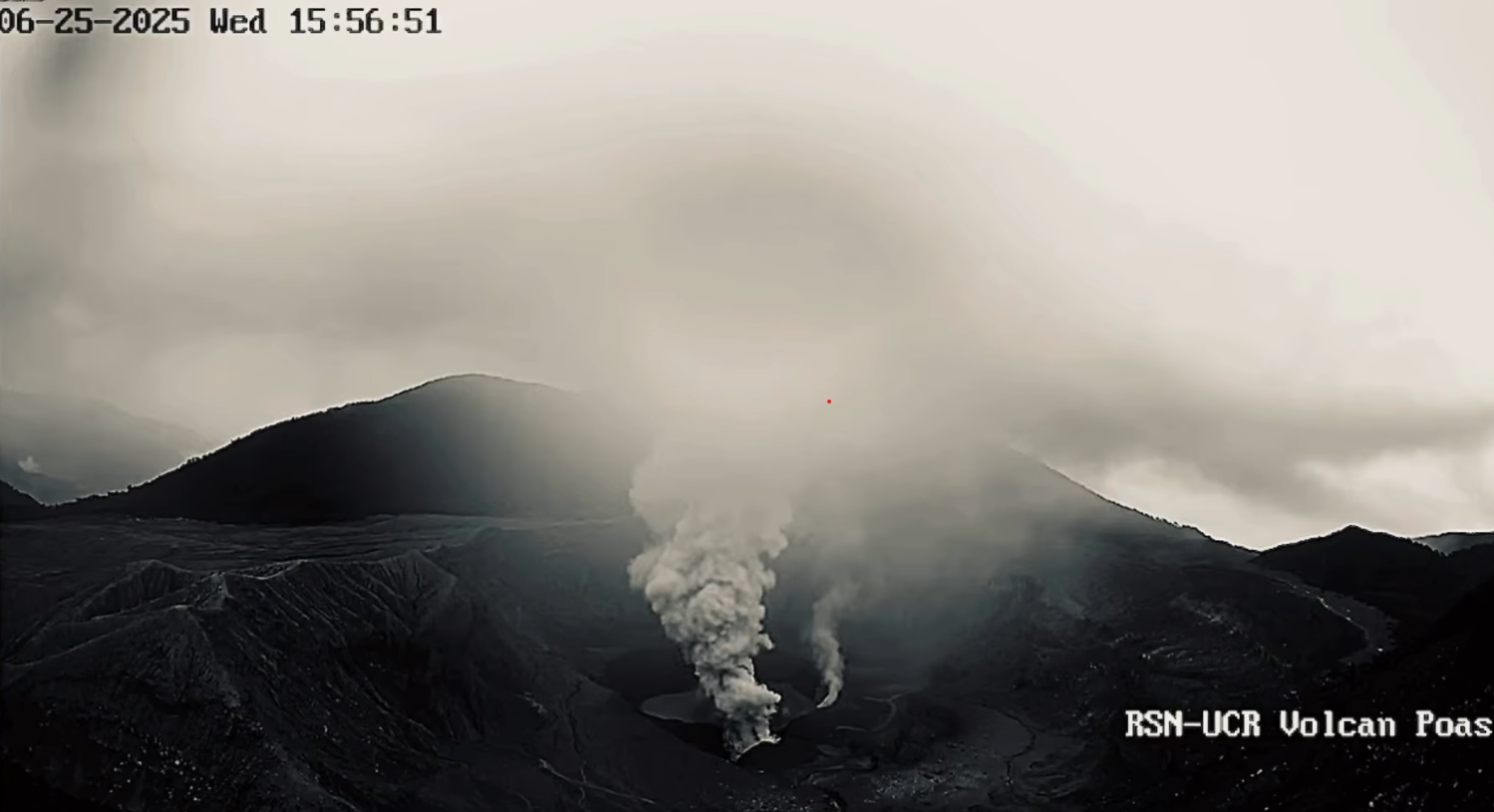
On September 7, the volcano erupted ash in the afternoon for several minutes. Regular seismic tremors and long-period LP events were observed. Since yesterday afternoon and early this morning, six proximal volcano-tectonic events have been recorded.
Degassing is continuing.
Environmental Conditions:
The wind is southwesterly; the summit remains cloudy.
Activity Level: Warning (2)
Date: September 8, 2025, Time: 5:27 PM
Plume Height (above the crater): 1,000 meters
Plume Observation Source: Webcam, seismic
Observed Activity:
Sporadic ash emissions were recorded starting at 5:27 PM, then more continuously after 7:50 PM.
The plume was strongly lifted by light winds and dispersed southwestward.
Source : Ovsicori .
Photo : Archive RSN-UCR.
Guatemala , Santiaguito :
Weather Conditions: Clear
Wind: Northeast
Precipitation: 20.0 mm
Activity
The Santiaguito Volcano Observatory reports faint white fumaroles erupting 350 meters above the dome of Dome Caliente, as well as weak and occasionally moderate explosions, occurring at a frequency of 2 to 3 per hour, projecting columns of gas and ash up to 900 meters above sea level.
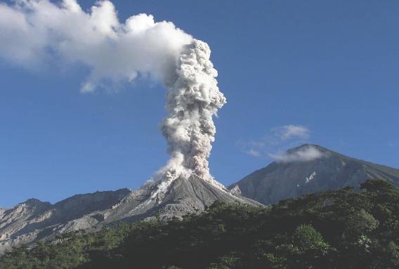
These explosions are moving west and southwestward due to the wind. Incandescence is observed on the dome, as well as the detachment of incandescent rock blocks towards the west and southwest flanks. Due to the wind direction, small particles of ash could fall on Loma Linda, La Tranquilidad and the surrounding area. Due to the abundant accumulation of rocky material on the Caliente Dome and on the promontory above the lava flow on its southwest flank, the latter could collapse and generate pyroclastic density currents over long distances towards the southwest, south, southeast and northeast. It is therefore advisable to follow the recommendations of Special Bulletin BESAN063-2025.
Source : Insivumeh
Photo : La Hora .