March 12 , 2026.
Hawaii , Kilauea :
HAWAIIAN VOLCANO OBSERVATORY STATUS REPORT , U.S. Geological Survey
Tuesday, March 10, 2026, 9:19 PM HST (Wednesday, March 11, 2026, 07:19 UTC)
19°25’16 » N 155°17’13 » W,
Summit Elevation 4091 ft (1247 m)
Current Volcano Alert Level: WATCH
Current Aviation Color Code: ORANGE
Activity Summary:
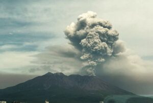
Episode 43 of the ongoing Halemaʻumaʻu eruption ended at 6:21 p.m. HST on March 10, 2026, and the ongoing Halemaʻumaʻu eruption is currently paused.
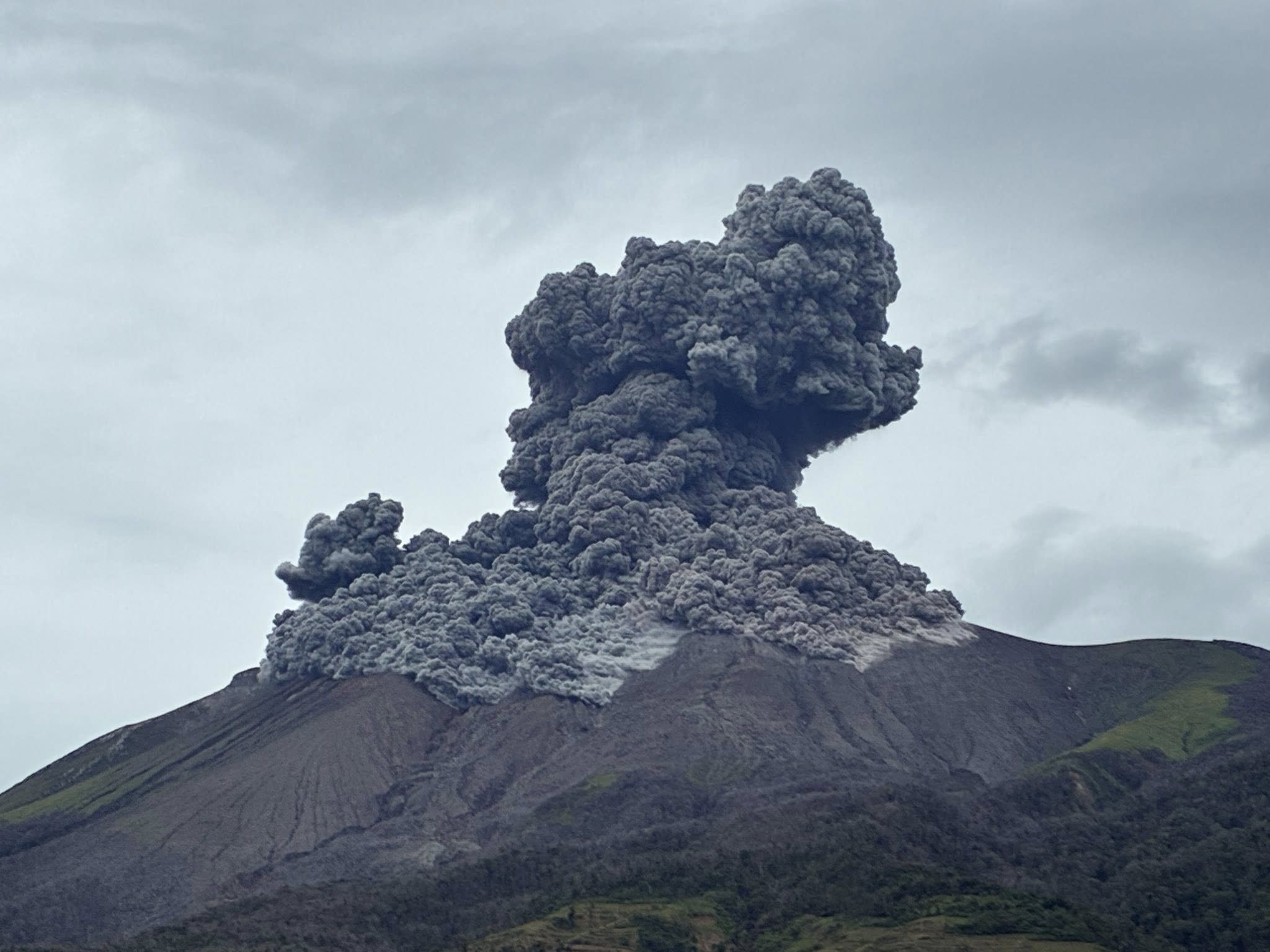
Tephra fall outside of the closed area of Hawaiʻi Volcanoes National Park along the north rim of Kaluapele (Kīlauea caldera) and into adjacent communities. Tephra as large as 6 inches was reported from the Volcano Golf Course and fine ash and Peleʻs hair was reported as far away as Hilo.
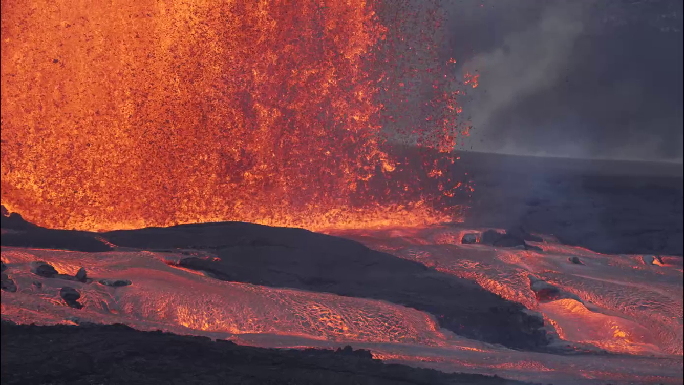
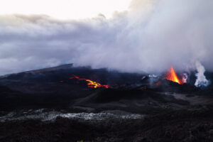
Activity during the episode 43 lava fountains at the summit of Kīlauea, from the south rim of the crater. This area provided clear views of the north and south fountains, and the lava channels that transported lava from the vent into the eastern portion of the crater floor.
Episode 43 Chronology:
Episode 43 lava fountaining from the north and south vents stopped at approximately 6:21 p.m. HST on March 10. The south fountain dropped suddenly at 6:18 p.m. HST and began irregular jetting. Both vents stopped suddenly at 6:21 p.m. HST after erupting to 500-600 feet (150-200 meters) high for the last hour. Episode 43 ended after 9 hours and 4 minutes with both the north and south vents active for most of the eruption. The highest peak or instantaneous effusion rate of 1000 cubic yards (800 cubic meters) per second occurred around 10:30 a.m. HST on March 10. Episode 43 ended with an average effusion rate of 400 cubic yards per second (300 cubic meters per second). An estimated 16 million cubic yards (12 million cubic meters) of lava erupted and covered about 50% of Halemaʻumaʻu crater floor. The Uēkahuna tiltmeter (UWD) recorded about 33.7 microradians of deflationary tilt during episode 43. The total erupted volume since December 2024 is now close to 325 million cubic yards (250 million cubic meters).
The onset of episode 43 fountaining of the ongoing Halemaʻumaʻu eruption occurred at 9:17 a.m. HST on March 10, 2026 about an hour after the start of precursory eruptions at 8:20 a.m. HST. The start of episode 43 was marked by a sharp increase in tremor and deflationary tilt recorded at the Uēkahuna tiltmeter (UWD). At first, the north vent grew rapidly, exceeding 100 meters (330 feet) in height by 10:00 a.m. and both north and south vents exceeding 1000 feet (300 meters) by 10:50 a.m. HST. North and south vent fountain heights peaked shortly after 11:00 a.m. HST, with maximum fountain heights during the episode estimated to be at least 1300 feet (400 meters) from both vents. After about 12:00 p.m. HST, the south vent fountain remained consistently about 10-30 percent higher than the north vent fountains for the majority of the eruption. By 2:00 p.m. HST the south vent had dropped to 1000 feet (300 meters) high and the north vent about 700 feet (220 meters) high. By 5:00 p.m. fountain heights for the south and north vents had dropped to 700 feet (220 meters) and 600 feet (180 meters) respectively.
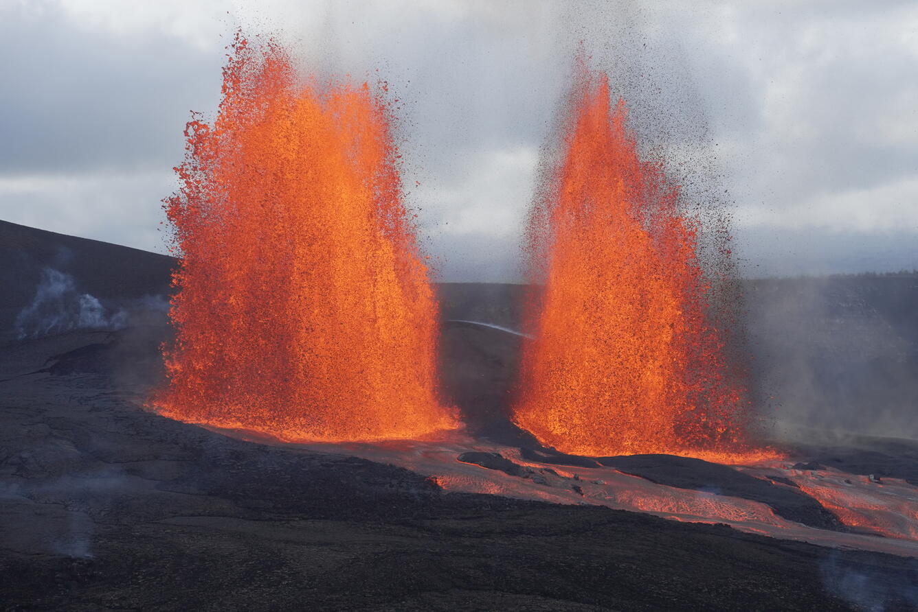
This photo was taken from the south rim of Halemaʻumaʻu crater and shows the south and north fountains active during episode 43 at the summit of Kīlauea.
The dual fountains produced significant heat and ash, creating a plume that reached10,000 feet (3050 meters) a.s.l. at 10:10 a.m. HST, over 20,000 feet (6100 meters) by 11:30 a.m. HST, and over 25,000 feet (7600 meters) a.s.l. by 10:50 a.m. HST. The maximum plume height exceeded 30,000 feet (9100 meters) a.s.l. by 11:30 a.m. HST. Light southwest winds at lower elevations pushed the plume and tephra fall to the north and east.
This eruption was comparable in size to episodes 41 and 42, but due to light winds produced tephra fallout similar to but not as great as episode 41. The plume sent tephra falling within Hawaiʻi Volcanoes National Park along the north rim of Kaluapele (Kīlauea caldera) and into adjacent communities. The heaviest tephra fall was recorded at Uēkahuna overlook (about 4-7 inches of accumulation) where 2-inch tephra began falling at around 10:20 a.m. HST and Kīlauea Military Camp (about 2 inches of accumulation) where 4-5 inch tephra fell starting at about 10:20 a.m. HST. The Volcano Golf Course community was hardest hit with a blanket of tephra with pieces up to several inches in diameter.
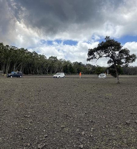
Nearly 5 hours into episode 43 of the ongoing eruption at Kīlauea, the lawn at Kīlauea Military Camp was covered with about an inch of tephra (2 to 3 cm). The underlying grass was barely visible. The deposit included reticulite bombs (large foamy tephra clasts) mixed in with smaller denser lapilli tephra.
Alert levels were raised from ORANGE / WATCH to RED / WARNING by the USGS Hawaiian Volcano Observatory at 10:54 a.m. HST reflecting potential hazards to surrounding communities and aviation. Highway 11 was closed at about 11:10 a.m. HST and Hawaiʻi Volcanoes National Park (HVNP) closed the western overlooks at about 11:20 a.m. HST and evacuated visitors from those areas. The National Weather Service issued an ash fall WARNING at 11:29 a.m. HST following an earlier ash fall advisory. HVNP closed a short time later. Smaller but significant tephra falls occurred in Volcano Village and Mauna Loa estates with lighter tephra as far as Royal Hawaiian Estates, about 6 miles northeast of the vents. As the eruption progressed, ash and Pele’s hair was reported from Mountain View and finally as far as Hilo, Hawaiian Paradise Park, and the Hamakua Coast just north of Hilo.
Source : HVO.
Photos : USGS / M. Patrick , USGS / N. Deligne .
Italy / Sicily , Etna :
Etna Activity Update, March 11, 2026, 12:10 PM (11:10 UTC).
The National Institute of Geophysics and Volcanology, Etna Observatory, reports that activity at the summit craters is characterized by degassing, particularly affecting the Northeast Crater. No signs of ongoing eruptive activity are currently observed.
However, visibility is limited by cloud cover.
The average amplitude of volcanic tremor, which began around 04:40 (UTC), showed an upward trend and reached high values around 06:15 (UTC).
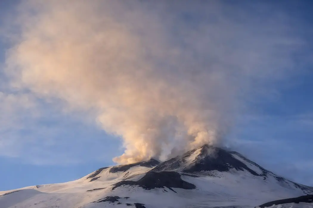
Currently, amplitude values remain high, although a downward trend began after reaching its peak around 08:10 (UTC).
The center of gravity of the volcanic tremor sources is currently located in the Voragine crater area, at an altitude of approximately 2,800 m. No changes in infrasound activity have been recorded. This activity remains localized in the Northeast crater, with a frequency fluctuating between medium and high.
Ground deformation monitoring network signals indicate a slight change in trend at the DRUV dilatometer and the inclinometer at the Piano Crater.
Further information will be released soon.
Source et photo : INGV.
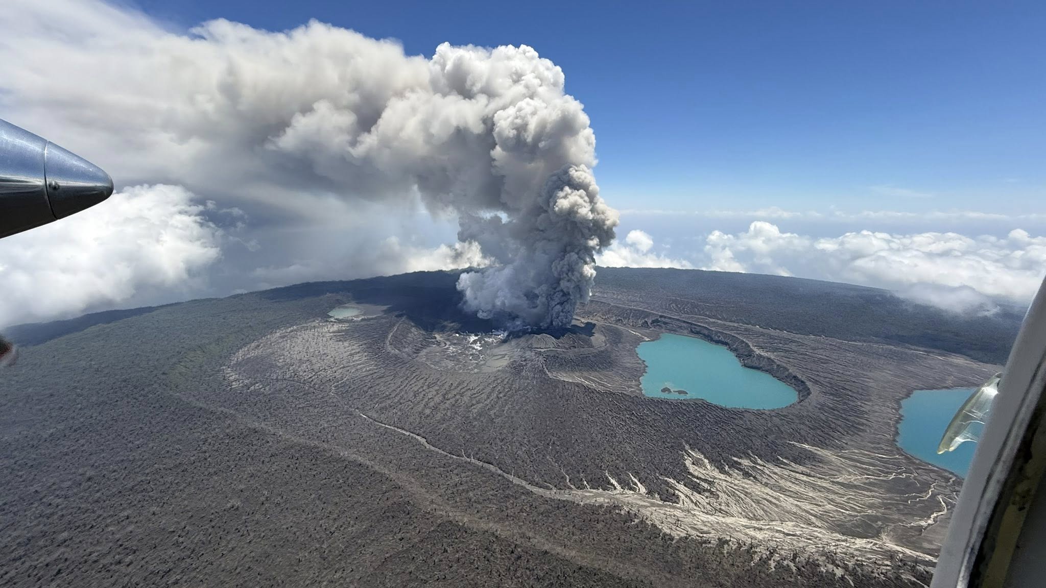
Peru , Sabancaya :
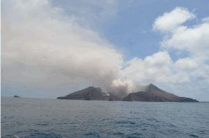
The Instituto Geofísico del Perú’s (IGP) Centro Vulcanológico Nacional (CENVUL) reported continuing eruptive activity at Sabancaya during 26 February-4 March. The seismic network detected 5-21 daily earthquakes indicating the movement of magma and gases. As many as six daily thermal anomalies were identified in satellite images. Ash, steam, and gas plumes rose as high as 1.2 km above the summit during 25-27 February. An explosion at 13h06 on 28 February generated an ash plume that rose 2.3 km above the summit. Eight explosions were detected during 28 February-4 March. One of the explosions, at 07h00 on 1 March, generated an ash plume that rose 3 km above the summit; another, at 14h30 on 2 March, generated an ash plume that rose 2.5 km above the summit. Explosions at 08h47 on 3 March and at 10h15 on 4 March produced ash plumes that rose 2 km above the summit.
According to a news article the explosion at 10h15 on 4 March and one later that day, at 17h17, produced ash plumes that drifted farther than 10 km; the ash plume from the second explosion caused ashfall in Maca (15 km NE), Lari (15 km NNE), Madrigal (15 km NNE), Cabanaconde (15 km NW), and Tapay (17 km NNW). In general the plumes drifted in multiple directions during the week and dissipated within 10 km. The Alert Level remained at Orange (the third level on a four-color scale) and the public was warned to stay outside of a 12 km radius from the summit.
Sources: Instituto Geofísico del Perú (IGP), Grupo RPP, GVP.
Photo : IGP ( archive).
Philippines , Kanlaon :
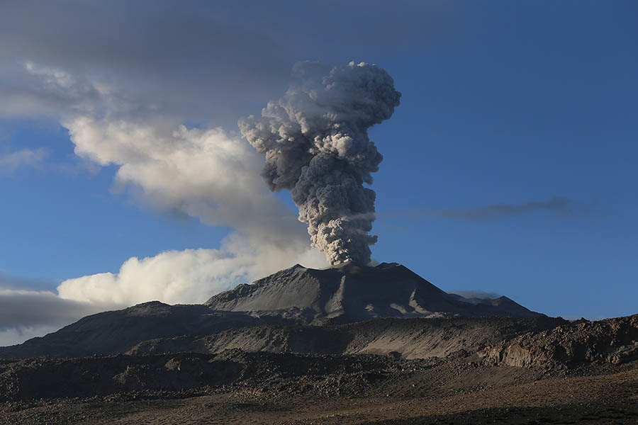
The Philippine Institute of Volcanology and Seismology (PHIVOLCS) reported continuing eruptive activity at Kanlaon during 26 February-4 March. A two-minute, moderately explosive eruption at 19h04 on 26 February generated a dense, dark gray ash plume that rose 2.5 km above the summit and drifted SW. Lightning in the ash plume was visible at least three times. Incandescent ballistics were ejected as high as 1.5 km above the summit crater rim and landed as far as 1 km S and 1.5 km SE, briefly forming a glowing ring of deposits at the summit area. Incandescent, hot ejecta ignited two fires along the forest margins on the upper S and SE flank. Pyroclastic density currents (PDCs) descended the E and SE flanks as far as 2 km. A shockwave produced a booming sound, heard up to 30 km away, that registered as a maximum of 218 pascals by an infrasound station about 4 km SE. Rumbling sounds attributed to the explosion were reported as far away as Southern Leyte, more than 175 km E. The event was followed by continuous and abundant ash emissions the persisted for an hour and 17 minutes and dispersed ash extensively over parts of the southern Negros Island Region.
Various amounts of ashfall were reported in 121 barangays (neighborhoods) in 16 cities/municipalities of Negros Occidental, with the heaviest ashfall in the municipalities of La Castellana and Pontevedra. The cities/municipalities that reported ashfall, a sulfur odor, and heard or felt the explosion include La Castellana, La Carlota City, Himamaylan, and Hinigaran; those that reported ashfall and a sulfur odor are San Carlos City, and Isabela; those that reported ashfall only include Pontevedra, Kabankalan, Ilog, Cauayan, Sipalay, Binalbagan, and Hinoba-an; those that reported a sulfur odor only include Moises Padilla and Murcia; residents of Bago City reported a sulfur odor and a shockwave. Sulfur dioxide emissions decreased to a notably low average of 194 tonnes/day (t/d) immediately prior to the eruption. Continuous sulfur dioxide emissions averaged 2,800 t/d since unrest began in June 2024 and averaged 1,460 t/d in 2026.
The seismic network recorded six volcanic earthquakes and two periods of volcanic tremor, 6 and 39 minutes long, during 26-27 February, and 5-21 daily volcanic earthquakes during the rest of the week. Ash emissions at 09h43 on 27 February drifted SW. Daily emissions during 28 February-2 March rose as high as 300 m above the summit and drifted SW. Sulfur dioxide emissions ranged from 420 to 2,880 tonnes per day during 27 February-1 March, then decreased to 420 t/d on 2 March. The Alert Level remained at 2 (on a scale of 0-5); the public was warned to stay out of the 4-km-radius Permanent Danger Zone (PDZ) and pilots were advised to avoid flying close to the summit.
Sources: Philippine Institute of Volcanology and Seismology (PHIVOLCS) , GVP.
Photo : Leah Pahayahay Martinez.
Vanuatu Archipelago , Ambae :
The Vanuatu Meteorology and Geohazards Department (VMGD) reported continuing eruptive activity at Ambae during 25 February-4 March. Seismicity remained high and was characterized by continuous volcanic tremor and volcano-seismic events. Continuous gas-and-ash emissions were visible in webcam images on 25 February and 1 March, and high amounts of sulfur dioxide continued to be detected in satellite images. On 27 February a video posted by VMGD showed gas, steam, and ash emissions being vigorously emitted from the main vent; incandescence was visible at the base of the plume. Ground observations on multiple days indicated that sulfurous mud was visible flowing in some of the creek drainages and that ash fell in areas to the SW and SE.
The Wellington Volcanic Ash Advisory Centre (VAAC) reported that during 28 February-2 March and on 4 March ash plumes were visible in webcam and satellite images rising as high as 4.3 km (14,000 ft) a.s.l., or about 2.1 km above the summit; weather clouds sometimes obscured satellite views. The Alert Level remained at 3 (on a scale of 0-5), and the public was warned to stay outside of Danger Zone B, defined as a 3-km radius around the active vents in Lake Voui, and to stay away from drainages during heavy rains.
Sources: Vanuatu Meteorology and Geohazards Department (VMGD), Wellington Volcanic Ash Advisory Center (VAAC) , GVP.
Photo : Unity Airlines Vanuatu .