January 15 , 2026.
Alaska , Pavlof :
AVO/USGS Volcanic Activity Notice
Current Volcano Alert Level: ADVISORY
Previous Volcano Alert Level: NORMAL
Current Aviation Color Code: YELLOW
Previous Aviation Color Code: GREEN
Issued: Wednesday, January 14, 2026, 11:03 AM AKST
Source: Alaska Volcano Observatory
Notice Number: 2026/A29
Location: N 55 deg 25 min W 161 deg 53 min
Elevation: 8261 ft (2518 m)
Area: Alaska Peninsula
Volcanic Activity Summary:
The rate of long-period earthquakes has increased at Pavlof Volcano since approximately 12:45 am AKST (09:45 UTC) on January 14. No eruptive activity or emissions from the summit have been observed including in clear webcam images from this morning. The earthquake activity represents an increase from background levels, therefore the Alaska Volcano Observatory is raising the Aviation Color Code and Alert Level to YELLOW/ADVISORY. This type of earthquake activity in the past has preceded eruptions, but also has ended without an eruption occurring. We will continue to closely monitor the volcano for signs of increased activity, as eruptions at Pavlof Volcano often occur suddenly with little or no warning.
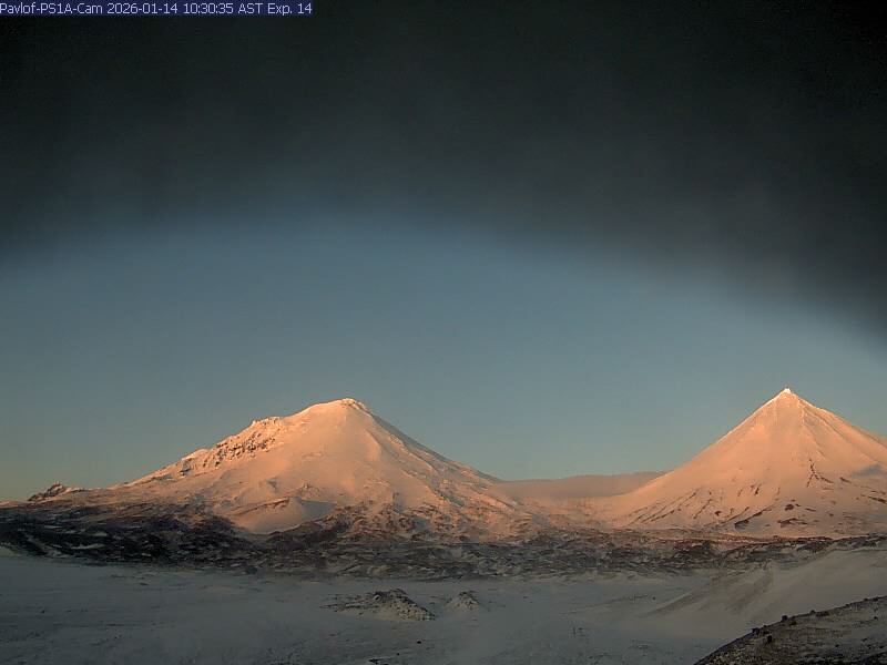
This image shows two snow-covered peaks in the first light of morning. The one on the right (Pavlof Sister) is a very symmetrical triangle from this perspective, while the one on the left (Pavlof Volcano) is a little less regular in shape. A little fog is present in the saddle between the peaks.
The last eruption at Pavlof Volcano occurred in 2021 and 2022, and consisted of small lava flows and low-level explosions primarily from a vent on the upper southeast flank. Larger ash-producing eruptions last occurred at Pavlof in 2013, 2014, and 2016 from a crater on the upper north flank.
Pavlof Volcano is monitored by local seismic and infrasound sensors, satellite data, web cameras, and regional infrasound and lightning networks.
Remarks:
Pavlof Volcano is a snow- and ice-covered stratovolcano located on the southwestern end of the Alaska Peninsula about 953 km (592 mi) southwest of Anchorage. The volcano is about 7 km (4.4 mi) in diameter and has active vents on the north and east sides close to the summit. With over 40 historic eruptions, it is one of the most consistently active volcanoes in the Aleutian arc. Eruptive activity is generally characterized by sporadic Strombolian lava fountaining continuing for a several-month period. Ash plumes as high as 49,000 ft ASL have been generated by past eruptions of Pavlof, and during the March 2016 eruption, ash plumes as high as 40,000 feet above sea level were generated and the ash was tracked in satellite data as distant as eastern Canada. The nearest community, Cold Bay, is located 60 km (37 miles) to the southwest of Pavlof.
Source : AVO.
Photo : Jacob, Ben David.
Philippines , Mayon :
The Philippine Institute of Volcanology and Seismology (PHIVOLCS) reported that escalating numbers of rockfalls preceded the extrusion of new lava at Mayon. Beginning in November 2025 rockfalls from the summit lava dome became more frequent based on visual and seismic observations. A total of 599 rockfalls were recorded during November-December, averaging 21 events per day. Photos of the summit dome on 8 and 10 December revealed that dark lava spines had been recently extruded. On 31 December a total of 47 rockfalls were recorded, the highest number recorded in a single day in 2025. Ground deformation had been anomalous for the previous 18 months, notably at the E and NE flanks; inflation at the W and SW flanks began to be detected in May 2025. At 06h00 on 1 January 2026 the Alert Level was raised to 2 (on a 0-5 scale); the public was warned to stay out of the 6-km-radius Permanent Danger Zone (PDZ) and pilots were advised to avoid flying close to the summit.
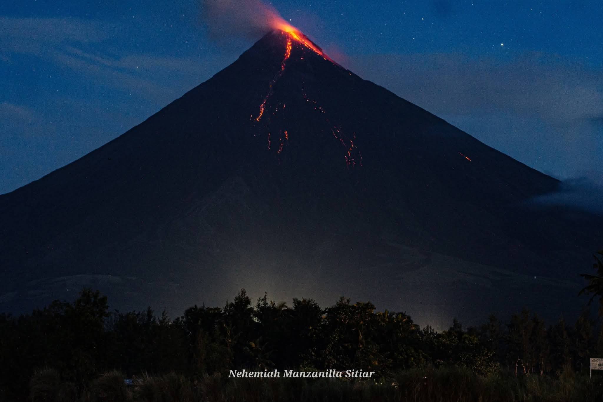
Sulfur dioxide emissions remained at background levels, averaging 288 tonnes per day (t/d) on 2 January and 702 t/d on 5 January. The seismic network continued to detect a high number of rockfalls from the unstable summit dome; a total of 346 rockfalls were recorded during 1-6 January as well as four volcanic earthquakes. The rockfalls lasted 1-5 minutes and descended the S flank less than 1 km. The volume of the rockfalls increased on 5 January and incandescence at the summit was seen at night, indicting the extrusion of new lava at the summit. Beginning at 12h26 on 6 January a collapse of new material from the summit generated a three-minute-long pyroclastic density current (PDC) that traveled less than 2 km down the Bonga drainage on the SE flank. At 13h20 the Alert Level was raised to 3. The Albay Provincial Information Office reported that the governor ordered the evacuation of residents living within the PDZ. Activity continued to increase through the day; in total there were 131 rockfalls and five PDCs detected on 6 January .
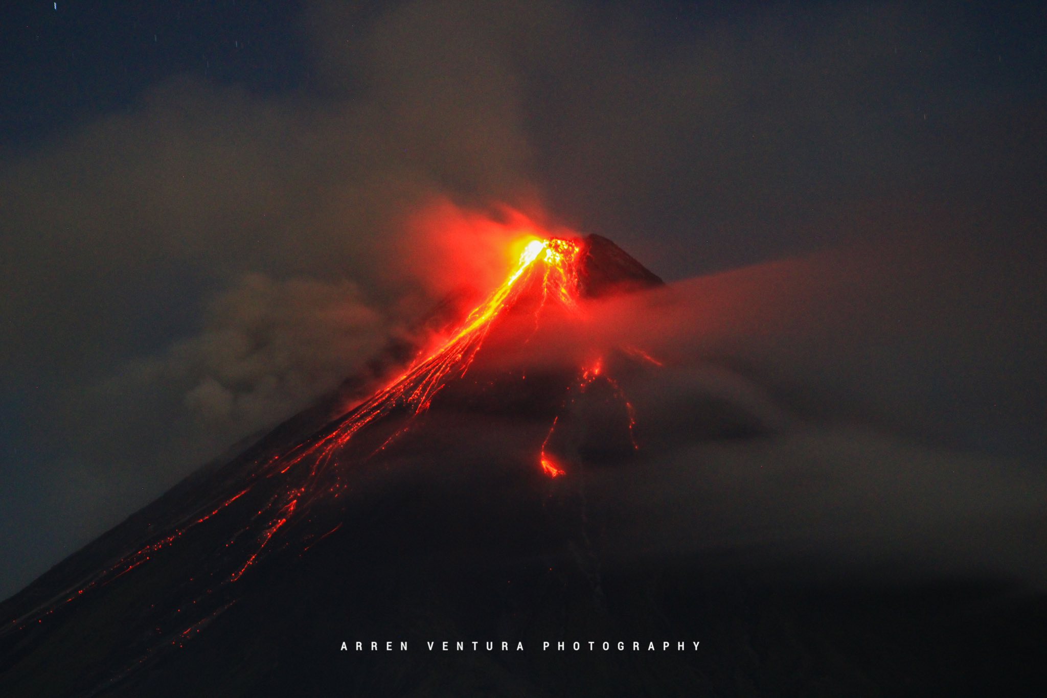
By 06h00 on 7 January a total of 3,476 people (952 families) had moved to 13 evacuation shelters, and an additional 39 people (12 families) were staying with friends or relatives, according to a report from the Disaster Response Operations Monitoring and Information Center (DROMIC). Collapses at the summit dome continued on 7 January; a total of 16 discrete PDC events were recorded during 12h26-16h30, generating grayish to brownish ash clouds that rose 200 m and drifted ENE. According to the Tokyo VAAC ash plumes during 14h58-19h28 on 7 January rose 2.4-3 km (8,000-10,000 ft) a.s.l., or as high as 580 m above the summit, and drifted NW and ENE.
Sources: Philippine Institute of Volcanology and Seismology (PHIVOLCS), Disaster Response Operations Monitoring and Information Center (DROMIC), Tokyo Volcanic Ash Advisory Center (VAAC), Albay Provincial Information Office , GVP.
Photos : Nehemiah Manzanilla Sitiar , Arren Christian Ventura .
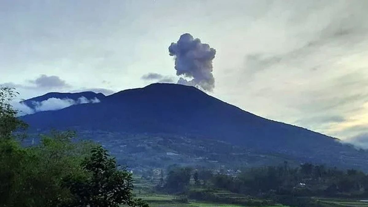
Indonesia , Marapi :
Mount Marapi experienced an eruption on Wednesday, January 14, 2026 at 9:36 AM WIB. An ash column was observed approximately 1,600 meters above the summit (at an altitude of about 4,491 meters). This ash column was gray and dense, drifting northeast. At the time of writing, the eruption was still ongoing.
VOLCANO OBSERVATORY NOTICE FOR AVIATION – VONA
Issued : January 14, 2026.
Volcano : Marapi (261140)
Current Aviation Colour Code : ORANGE
Previous Aviation Colour Code : orange
Source : Marapi Volcano Observatory
Notice Number : 2026MAR008
Volcano Location : S 0 deg 22 min 52 sec E 100 deg 28 min 23 sec
Area : West Sumatra, Indonesia
Summit Elevation : 9251 FT (2891 M)
Volcanic Activity Summary :
Eruption with volcanic ash cloud at 02h36 UTC (09h36 local).
Volcanic Cloud Height :
Best estimate of ash-cloud top is around 14371 FT (4491 M) above sea level or 5120 FT (1600 M) above summit. May be higher than what can be observed clearly. Source of height data: ground observer.
Other Volcanic Cloud Information :
Ash cloud moving to northeast. Volcanic ash is observed to be gray. The intensity of volcanic ash is observed to be thick.
Remarks :
Eruption recorded on seismogram with maximum amplitude 28.6 mm and maximum duration 31 second. Tremor recorded on seismogram with maximum amplitude 1.5 mm.
Source et photo : Magma Indonésie .
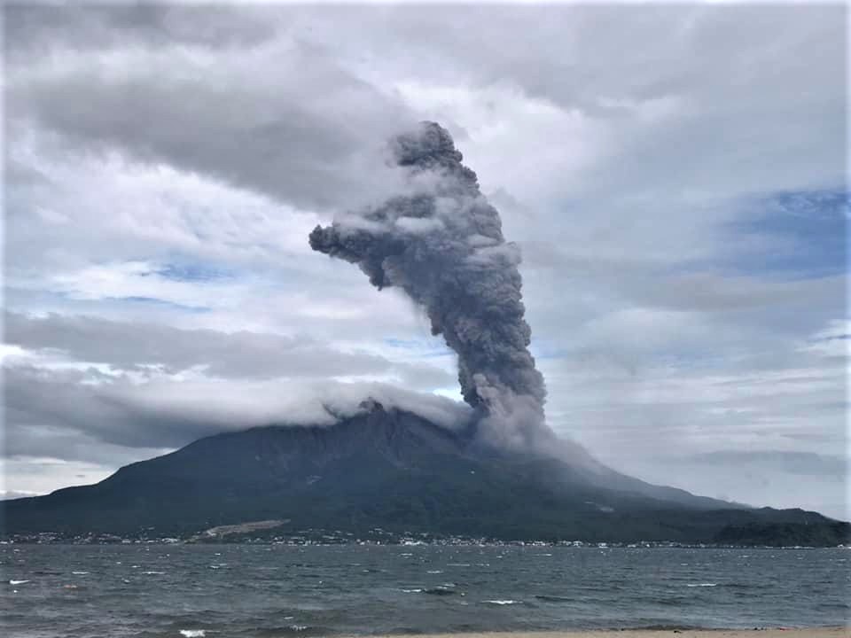
Japan , Sakurajima :
The Japan Meteorological Agency (JMA) reported ongoing eruptive activity at Minamidake Crater (Aira Caldera’s Sakurajima volcano) during 29 December 2025-6 January 2026. Nightly crater incandescence was visible in webcam images and small eruptive events were occasionally detected. A period of continuous emissions during 15h58-17h10 on 6 January produced ash plumes that rose as high as 1 km above the crater rim and drifted S. The Alert Level remained at 3 (on a 5-level scale), and the public was warned to be cautious within 2 km of both the Minimadake and Showa craters.
The Aira caldera in the northern half of Kagoshima Bay contains the post-caldera Sakurajima volcano, one of Japan’s most active. Eruption of the voluminous Ito pyroclastic flow accompanied formation of the 17 x 23 km caldera about 22,000 years ago. The smaller Wakamiko caldera was formed during the early Holocene in the NE corner of the caldera, along with several post-caldera cones. The construction of Sakurajima began about 13,000 years ago on the southern rim and built an island that was joined to the Osumi Peninsula during the major explosive and effusive eruption of 1914. Activity at the Kitadake summit cone ended about 4,850 years ago, after which eruptions took place at Minamidake. Frequent eruptions since the 8th century have deposited ash on the city of Kagoshima, located across Kagoshima Bay only 8 km from the summit. The largest recorded eruption took place during 1471-76.
Sources : Japan Meteorological Agency (JMA), GVP
Photo : Koki Arima .
Costa Rica , Poas :
Daily Volcanic Activity Bulletin. OVSICORI-UNA, January 13, 2026
Update: 11:02:00
Latitude: 10.200
Longitude: -84.233
Altitude: 2,687 m
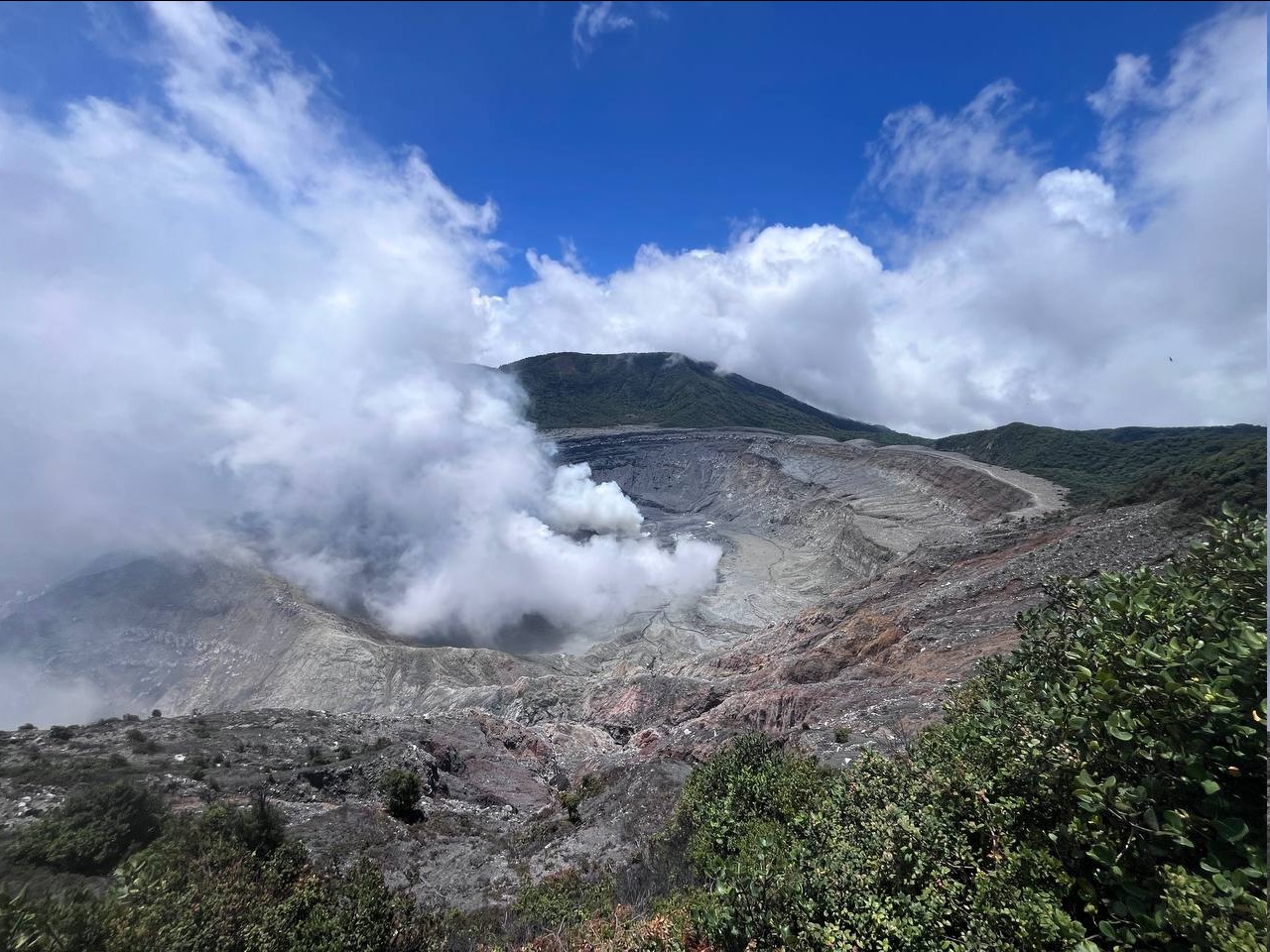
Observed Activity:
Significant degassing of the fumarole located above Boca B and Laguna Caliente. The lake level continues to drop. Seismic tremor is very low. The CO₂/SO₂ ratio continues to decrease (0.22), while the SO₂ concentration increases (51.2 ppm). This morning, the SO₂ concentration measured at the observation point was less than 0.4 ppm.
Environmental Conditions: Cloudy skies with southwest wind (4 m/s).
Activity Level: Alert (2).
Source : Ovsicori .
Photo : RSN-UCR.