February 6 , 2026.
Philippines , Mayon :
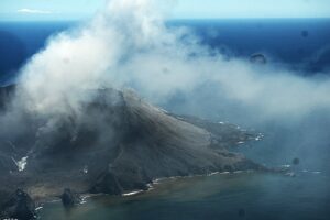
The Philippine Institute of Volcanology and Seismology (PHIVOLCS) reported that the eruption at Mayon continued during 28 January-4 February, characterized by effusion and collapses at the summit dome, pyroclastic density currents (PDCs), rockfalls, ash plumes, avalanches of incandescent material, and lava flows. Episodic and minor Strombolian activity was visible on 28 January. Moderate emissions rose as high as 1 km above the summit and drifted in various directions during 28-30 January and on 4 February; weather clouds obscured views on the other days. The seismic network recorded 284-389 daily rockfall events and 26-68 daily PDCs. The number of volcanic earthquakes recorded was variable: 119 on 28 February, 21 on 29 February, and 0-9 daily the rest of the week. Sulfur dioxide emissions increased each day, averaging 1,275 tonnes per day (t/d) on 28 January and rising to 5,297 t/d by 3 February. Sulfur dioxide emissions peaked at 6,569 t/d on 4 February, the highest average recorded in the past 15 years.
According to a news report ashfall was reported on 2 February in at least five villages including Quirangay, Sua, Tumpa, Libod and Anoling. Ash fell with rain causing reduced road visibility and affecting local farmlands. By 18h00 on 4 February a total of 4,058 people (1,115 families) were staying in 13 evacuation shelters, and an additional 53 people (17 families) were staying with friends or relatives, according to the Disaster Response Operations Monitoring and Information Center (DROMIC). The Alert Level remained at 3 (on a 0-5 scale) and residents were reminded to stay away from the 6-km-radius Permanent Danger Zone (PDZ). PHIVOLCS recommended that civil aviation authorities advise pilots to avoid flying close to the summit.
Sources: Philippine Institute of Volcanology and Seismology (PHIVOLCS), Disaster Response Operations Monitoring and Information Center (DROMIC), Inquirer.net , GVP.
Photo : Rick Estillomo.
Kamchatka , Sheveluch :
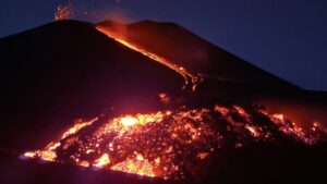
The Kamchatkan Volcanic Eruption Response Team (KVERT) reported continuing eruptive activity at Sheveluch’s “300 years of RAS” dome on the SW flank of Old Sheveluch and at the Young Sheveluch dome during 28 January-4 February. A daily thermal anomaly was identified in satellite images. Tall ash plumes were generated on a few days during the week. An explosive period that began at 00h30 on 29 January produced ash plumes that rose 4 km (13,100 ft) a.s.l. and drifted 35 WSW by 00h50 based on satellite images. At 21h10 on 31 January an ash plume rose 6 km (19,700 ft) a.s.l. and drifted 70 km WNW. Explosions generated an ash plume rose 11 km (36,100 ft) a.s.l. at 01h30 on 2 February; the 24 x 34 km plume was identified in a satellite image drifting 50 km NNE. At 02h20 the Aviation Color Code was raised to Red (the highest level on a four-color scale).
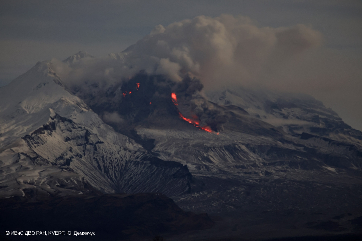
Explosions a few hours later produced ash plumes that rose 7.5 km (24,600 ft) a.s.l. by 04h05 and drifted 36 km NE. The previous ash cloud was 135 x 60 km and was 228 km NW. At 06h14 the Aviation Color Code was lowered to Orange. An explosion on 3 February generated an ash cloud that was 25 x 15 km, rose to 11.5 km (37,700 ft) a.s.l. by 02h51, and drifted 80 km NW. At 03h45 the Aviation Color Code was raised to Red, but then lowered back to Orange at 05h52. According to the Kamchatka Volcanological Station (Volkstat) the NW part of the lava dome was active and glowing ash plumes with frequent lightning strikes had recently been observed at night. Dates are based on UTC; specific events are in local time where noted.
Sources: Kamchatkan Volcanic Eruption Response Team (KVERT), Kamchatka Volcanological Station, GVP.
Photo : Yu. Demyanchuk, IVS FEB RAS, KVERT , GVP.
Democratic Republic of Congo , Nyamulagira :
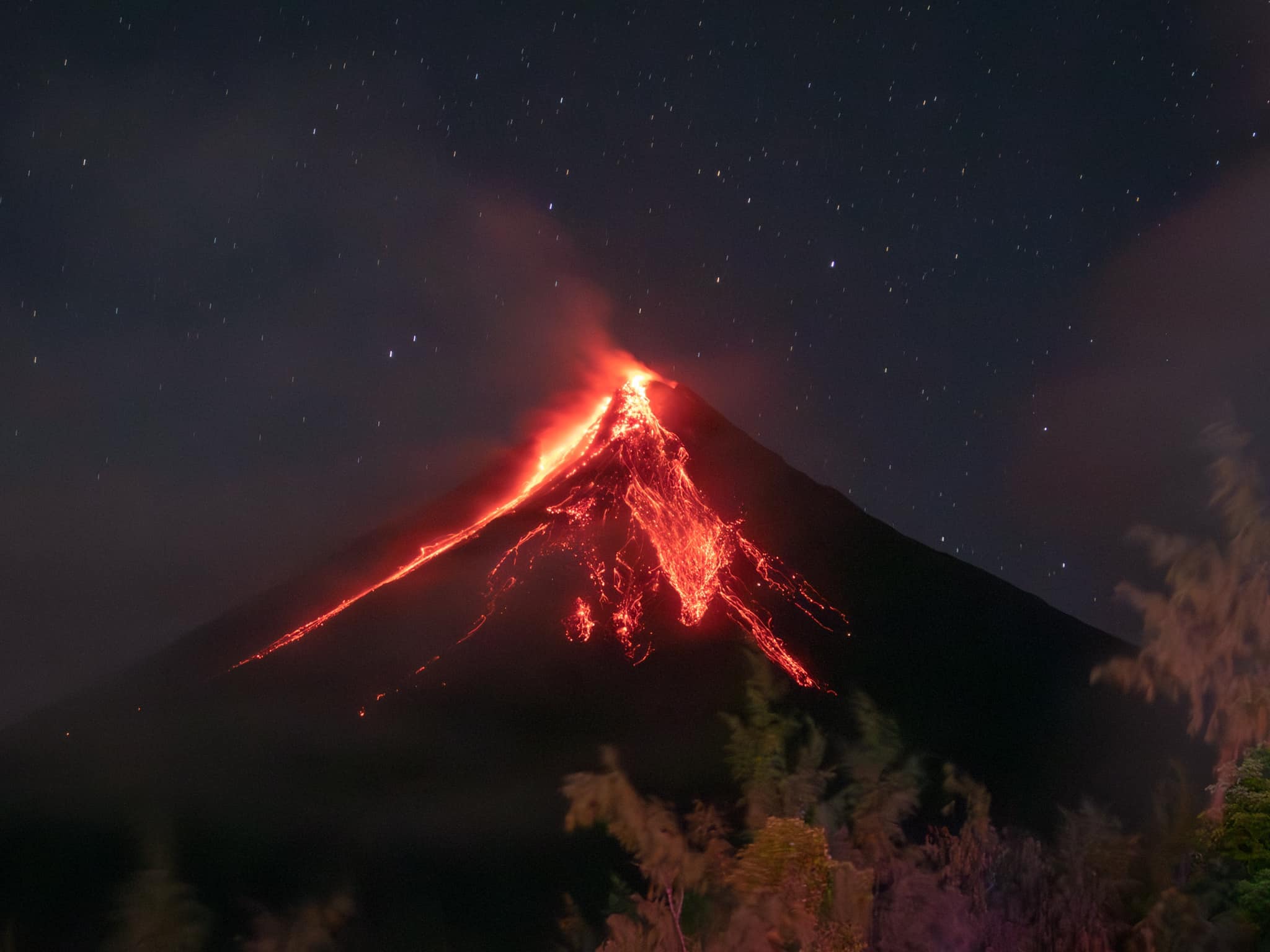
The eruption at Nyamulagira continued in January, with observations based on satellite images. Incandescence on the floor of the summit caldera and from active lava flows on the WNW and NW flanks were visible in a clear 21 January satellite image and a mostly cloudy image from 31 January. The distal end of the farthest lava flow was about 8 km from the crater rim.
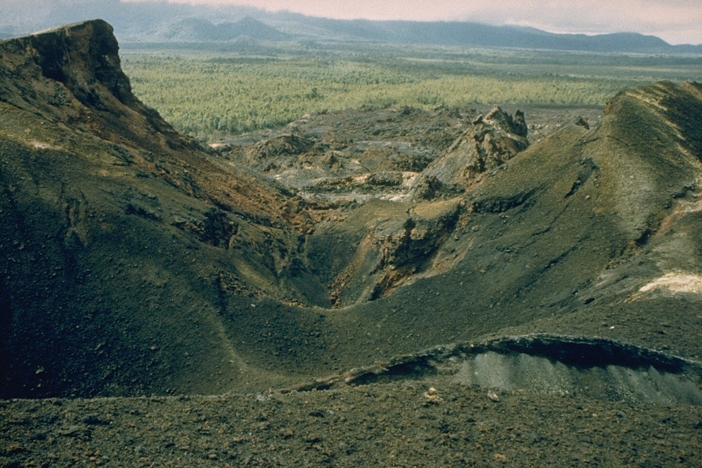
The 1986 Kitazungurwa fissure is seen in this 1987 photo. The south flank eruption produced a scoria cone and a lava flow that traveled 19 km down the SW flank. The flow traveled to within 2 km of the highway along the north shore of Lake Kivu between Goma and Sake.
Africa’s most active volcano, Nyamulagira (also known as Nyamuragira), is a massive high-potassium basaltic shield about 25 km N of Lake Kivu and 13 km NNW of the steep-sided Nyiragongo volcano. The summit is truncated by a small 2 x 2.3 km caldera that has walls up to about 100 m high. Documented eruptions have occurred within the summit caldera, as well as from the numerous flank fissures and cinder cones. A lava lake in the summit crater, active since at least 1921, drained in 1938, at the time of a major flank eruption. Recent lava flows extend down the flanks more than 30 km from the summit as far as Lake Kivu; extensive lava flows from this volcano have covered 1,500 km2 of the western branch of the East African Rift.
Sources: Copernicus , GVP.
Photo : D. Meurhaeghe, 1987.
Colombia , Galeras :
San Juan de Pasto, February 3, 2026, 4:30 PM
Regarding the monitoring of activity at the Galeras volcano, the Colombian Geological Survey (SGC), an agency under the Ministry of Mines and Energy, reports the following:
For the period from January 27 to February 2, 2026, the main variations in monitored parameters compared to the previous week were as follows:
● Volcanic activity remained low, but a decrease in seismic activity and energy released was recorded. Seismicity associated with rock fracturing within the volcanic edifice predominated.
● Most events occurred northeast of the main crater, within 18 km and less than 12 km of the summit of Galeras (4,200 m altitude). The maximum recorded magnitude was 1.6, and no earthquakes were felt.
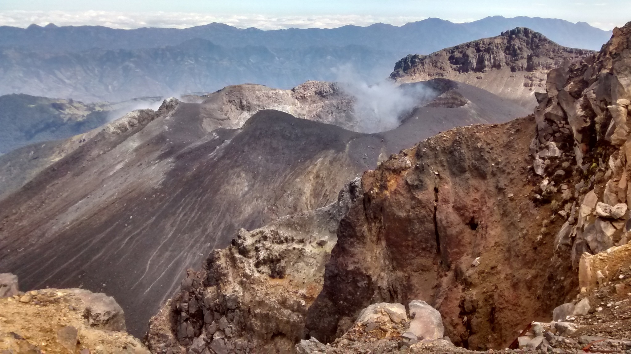
● During the week, low columns of white gas were observed, with varying dispersion depending on wind direction. These emissions originated primarily from the fumarole fields of El Paisita to the north, Las Chavas to the west, and the main crater.
● Other volcanic monitoring parameters remained stable.
Given the above, the Geological Survey of Colombia (SGC) recommends closely monitoring the situation by consulting the weekly bulletins and other information published through its official channels, as well as the instructions of local and departmental authorities and the National Unit for Disaster Risk Management (UNGRD).
Volcanic activity remains at the yellow alert level: active volcano exhibiting changes in the baseline behavior of monitored parameters and other manifestations.
Source et photo : SGC.
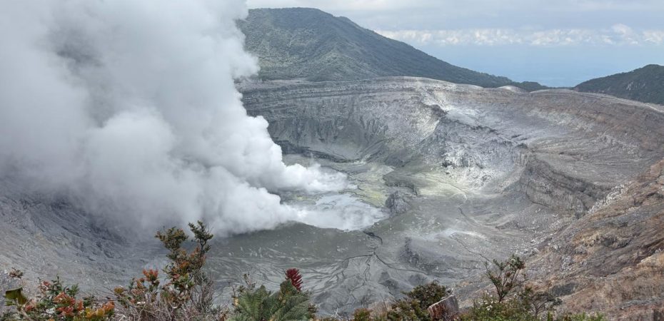
Costa Rica , Poas / Rincon de la Vieja :
Daily Volcanic Activity Bulletin. OVSICORI-UNA
Date: 05/02/2026, Updated: 08:44:00
Volcano: Poás
Latitude: 10.200
Longitude: -84.233
Altitude: 2,687 m
Observed Activity:
Seismic activity remains low, without significant tremor. The geodetic network records an uplift of the crater relative to the visitor center, as well as a slight extension in the southern sector of the volcano (VPCL and VPJA stations) relative to the same reference point. The CO₂/SO₂ ratio has been trending downward since February 3. The H₂S/SO₂ ratios and SO₂ concentrations remain within the values observed in recent days.
Environmental Conditions:
Winds are blowing from the southwest. Heavy cloud cover persists over the volcano. Activity level: Alert (2).
Volcano: Rincón de la Vieja
Latitude: 10.83
Longitude: -85.324
Altitude: 1,916 m
Observed Activity:
Seismic activity is low, with no significant tremor. Geodetic observations show no notable deformation, except for slight widening at the summit, consistent with a possible surface clogging process.
Environmental Conditions:
Winds are blowing from the southwest. Thick cloud cover persists over the volcano.
Activity Level: Alert (2)
Source et photo : Ovsicori .