
November 20 , 2026.
Chile / Argentina , Nevados de Chillan :
The eruption at Nevados de Chillán was ongoing during 12-18 November based on reports from the Servicio Nacional de Geología y Minería (SERNAGEOMIN), the Servicio Geológico Minero Argentino (SEGEMAR), and the Buenos Aires Volcanic Ash Advisory Center (VAAC). Based on webcam images SERNAGEOMIN reported that an eruptive event at 17h03 on 12 November was associated with a long-period earthquake and produced an ash-and-gas plume that rose 400 m above the summit. A pyroclastic flow descended the W flank, along the N side of the active lava flow, as far as 500 m.
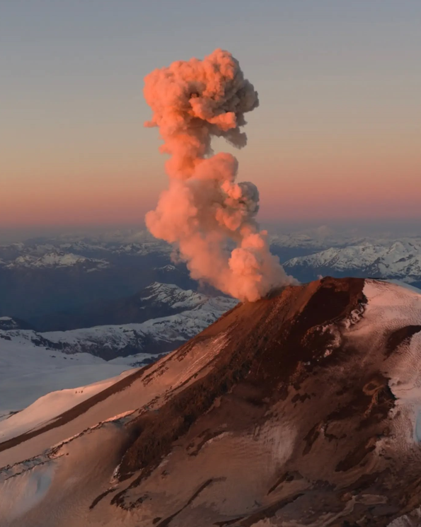
The Buenos Aires VAAC noted that during 13-14 November gas-and-steam plumes possibly containing ash were visible in satellite and webcam images and reported by a pilot rising as high as 4.3 km (14,000 ft) a.s.l, or just over 1 km above the summit, and drifting S and SE. The Alert Level remained at Estados de Actividad Volcánica (EAV) 3 (on a scale of 0-5). SEGEMAR maintained Alert Level Yellow (the second lowest level on a four-color scale). The Sistema y Servicio Nacional de Prevención y Repuesta Ante Desastres (SENAPRED) maintained an “Preventive Early Alert” for Pinto and Coihueco and warned the public to stay 2 km away from Emission Center 3 (EC3).
Sources: Buenos Aires Volcanic Ash Advisory Center (VAAC), Sistema y Servicio Nacional de Prevención y Repuesta Ante Desastres (SENAPRED), Servicio Nacional de Geología y Minería (SERNAGEOMIN), Servicio Geológico Minero Argentino (SEGEMAR), GVP.
Photo : Spataforediego.
Indonesia , Karangetang :
An eruption of Mount Karangetang occurred on Thursday, November 19, 2026, at 6:37 PM (Central Indonesian Time, WITA). The observed ash column reached a height of approximately 1,000 meters above the summit (about 2,784 meters above sea level). This dense, white-to-gray column was moving toward the north and northeast. At the time this report was published, the eruption was still ongoing.
Seismic observations:
1 eruption earthquake, with an amplitude of 50 mm and a duration of 87 seconds.
15 rockfall-related earthquakes, with amplitudes ranging from 4 to 17 mm and durations from 33 to 115 seconds.
227 emission earthquakes, with amplitudes ranging from 6 to 50 mm and durations from 18 to 103 seconds.
32 harmonic tremors, with amplitudes ranging from 8 to 50 mm and durations from 51 to 373 seconds.
29 non-harmonic tremors, with amplitudes ranging from 5 to 48 mm and durations from 52 to 347 seconds.
6 shallow volcanic earthquakes, with amplitudes ranging from 6 to 50 mm and durations from 1 to 13 seconds.
1 deep volcanic earthquake, with an amplitude of 31 mm and a duration of 12 seconds.
5 distant tectonic earthquakes, with amplitudes ranging from 7 to 20 mm and durations from 32 to 55 seconds.
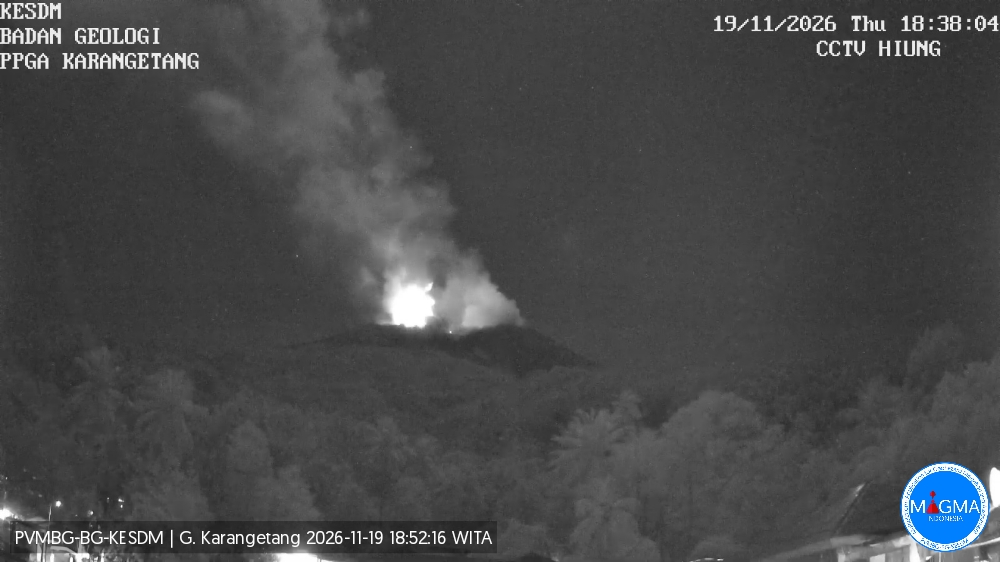
The Pusat Vulkanologi dan Mitigasi Bencana Geologi (PVMBG) reported that the eruption at Karangetang’s North Crater (Kawah Dua), characterized by the effusion of incandescent material, occasional small explosions, and periodic ash plumes, continued during 12-18 November. Incandescent material at the summit and on the flanks was visible in webcam images on most days. Rumbling sounds and occasional booms were reported. Eruptive events were recorded during 13-14 November but not visually confirmed. According to news articles lava flows or incandescent avalanches of material traveled as far as 1 km S, SW, and NW and 500-700 m NW. Incandescent material was ejected as high as 400 m above the summit. At 13h39 on 17 November a white, gray, and brown ash plume rose 800 m above the summit and drifted SW and W. The Alert Level remained at 2 (on a scale of 1-4) and the public was advised to stay 1.5 km away from both craters, with an extension to 2.5 km on the NW and SW flanks of North Crater.
Sources: Pusat Vulkanologi dan Mitigasi Bencana Geologi (PVMBG, also known as CVGHM), Antara News, Antara News, Antara News , GVP.
Photo : PVMBG.
Japan , Sakurajima :
The Japan Meteorological Agency (JMA) reported ongoing eruptive activity at Minamidake Crater (Aira Caldera’s Sakurajima volcano) during 9-16 November. Volcanologists conducted a field survey on 10 November and measured extremely high sulfur dioxide emissions, averaging 3,600 tons per day. Eruptive events at 10h38 and 11h21 on 12 November generated ash plumes that rose 1.2 km above the crater rim and drifted NW. Very small eruptive events were recorded during 13-16 November. The Alert Level remained at 3 (on a 5-level scale), and the public was warned to be cautious within 1 km of both the Minimadake and Showa craters.

The Aira caldera in the northern half of Kagoshima Bay contains the post-caldera Sakurajima volcano, one of Japan’s most active. Eruption of the voluminous Ito pyroclastic flow accompanied formation of the 17 x 23 km caldera about 22,000 years ago. The smaller Wakamiko caldera was formed during the early Holocene in the NE corner of the caldera, along with several post-caldera cones. The construction of Sakurajima began about 13,000 years ago on the southern rim and built an island that was joined to the Osumi Peninsula during the major explosive and effusive eruption of 1914. Activity at the Kitadake summit cone ended about 4,850 years ago, after which eruptions took place at Minamidake. Frequent eruptions since the 8th century have deposited ash on the city of Kagoshima, located across Kagoshima Bay only 8 km from the summit. The largest recorded eruption took place during 1471-76.
Sources: Japan Meteorological Agency (JMA) , GVP.
Photo : koki-arima ( archive)
Japan , Ioto /Iwo Jima :
An undersea eruption off Ioto, the island also known as Iwo Jima, has built about 50 hectares of new land, roughly the size of 10 Tokyo Domes. Satellite analysis released on November 17 showed the triangular landmass, formed by volcanic material piling up above the sea, has joined the island off its southern Okinahama coast. A Japan Coast Guard flight on November 13 found the eruption still going, with a plume rising about 300 metres and hot lava fragments being thrown into the air.
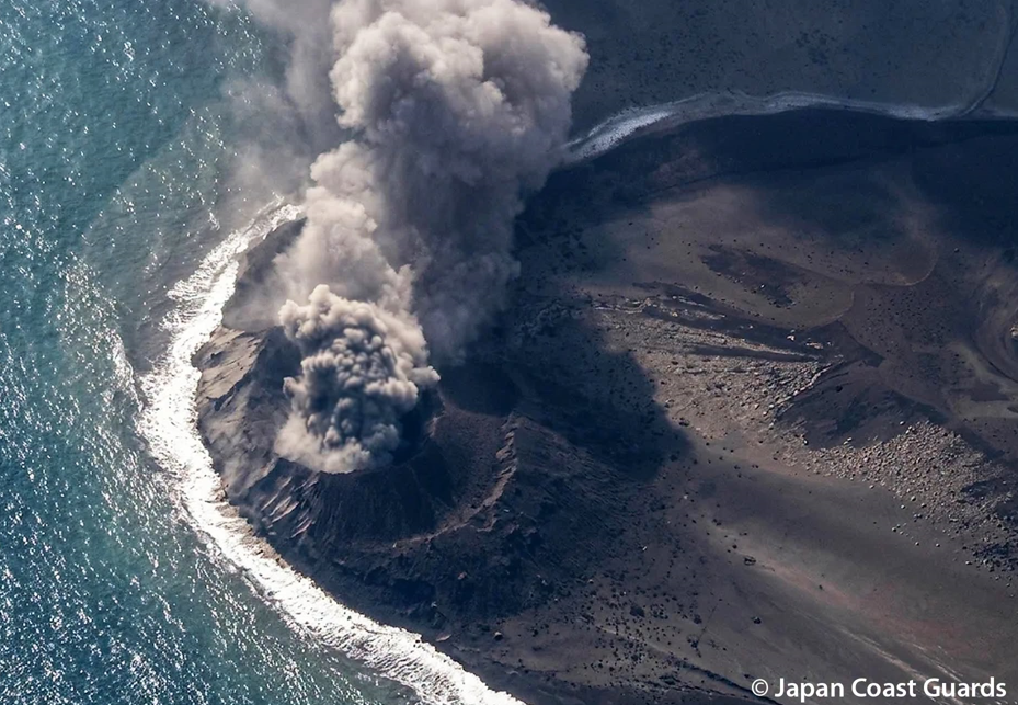
The eruption began on October 27, about 700 metres offshore and 1,200 kilometres south of Tokyo. A small island formed near the same spot in 2023 vanished within months as waves wore it away, so it is not yet known whether this new land will last. The Coast Guard has kept navigation warnings in place for ships nearby while the volcano remains active.
Estimated at approximately 300 meters in its greatest dimension on November 6, yet already connected to the main island a week later—on November 13—the islet expanded rapidly. During an overflight that day, a well-defined cone was visible, with incandescent fragments being ejected; this indicated reduced contact between seawater and the magma, a result of the explosion zone having risen to a higher elevation.
Source : Japan Daily .
Photo : Japan Coast Guard.
Philippines , Kanlaon :
The Philippine Institute of Volcanology and Seismology (PHIVOLCS) reported continuing eruptive activity at Kanlaon during 11-18 November. The seismic network generally recorded 1-8 daily volcanic earthquakes, though on 14 November there were 18 volcanic earthquakes including a period of volcanic tremor lasting two minutes. Sulfur dioxide emissions ranged from 1,848 to 3,540 tonnes per day. Volcanic emissions of variable densities rose as high as 1 km above the summit and drifted W, WSW, and SW.
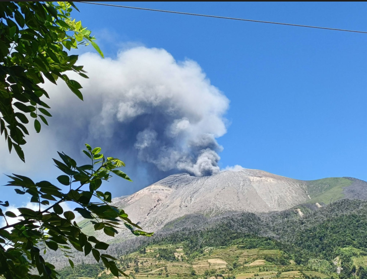
A grayish ash emission rose 600 m above the crater rim and drifted SW during 09h30-09h32 on 14 November. Four ash emissions lasting 11-71 minutes were detected on 15 November. Another grayish ash emission rose as high as 350 m above the crater rim and drifted SW during 06h35-07h55 on 16 November. The Alert Level remained at 2 (on a scale of 0-5); the public was warned to stay out of the 4-km-radius Permanent Danger Zone (PDZ) and pilots were advised to avoid flying close to the summit.
Sources: Philippine Institute of Volcanology and Seismology (PHIVOLCS), GVP.
Photo : Leah Cambarihan Pahayahay Martinez
