October 14 , 2026.
New Zealand , White Island :
Observation flight confirms no eruptive activity. Steam and gas emissions continue at Whakaari/White Island. Volcanic Alert Level remains at 2.
Published: Wed Oct 14 2026 10:00 AM
Volcanic Alert Level remains at 2
Aviation Colour Code remains at Yellow
Over this past week large steam and gas plumes were visible from the Bay of Plenty coast, enhanced by calm atmospheric conditions. An observation flight on Monday confirmed no explosive activity occurred. No eruptive activity has been observed since March, and the overall level of volcanic unrest remains unchanged. The Volcanic Alert Level remains at 2 and the Aviation Colour Code at Yellow.
Over this past week larger vivid white steam and gas plumes were observed on GeoNet webcams and were visible from the Bay of Plenty coast. The calm atmospheric conditions also led to an increased concentration of sulphur dioxide (SO2) gas being detected by satellite on 9 and 10 October. While gas emissions have fluctuated between measurement flights, CO2 and SO2 continue to show an overall decline since December 2024. No ash was detected in the atmosphere from satellite sensors.
Volcanic plumes are a common feature of Whakaari/White Island non-eruptive activity – often seen from the coast. They are emitted from active vents within the main crater and in calm conditions can stand kilometres high above the island. These non-eruptive, passive plumes – also referred to as “steam and gas” plumes, are mostly made up of water vapour with lesser amounts of sulphur and carbon gases. When combined with the right atmospheric conditions (still conditions, colder temperatures, and humidity) these plumes can increase in size – as was the case over this week.
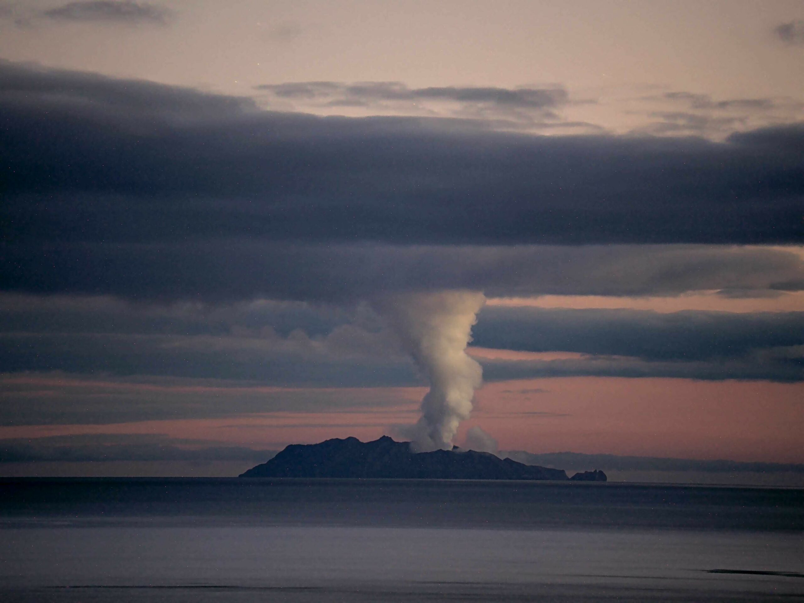
Figure 1: Image of the vivid white steam and gas plume from Whakatāne, rising to 1 km above the volcano at 5:50am on Saturday 10 October. The plume merges into high level cloud above the volcano.
An observation flight on 12 October saw no sign of recent explosive activity. There was no ash visible in the plume, while vent temperatures remained relatively low, less than 100°C.
These observations are consistent with minor volcanic unrest described in the previous two updates. While Whakaari/White Island is not currently erupting, volcanic activity could escalate with little or no warning, potentially affecting the crater floor area and immediate vicinity of the island.
Given our current lack of real-time monitoring data from the island, we cannot distinguish between Volcanic Alert Level 1 and 2 and Aviation Colour Code Green and Yellow. As a result, Whakaari/White Island will remain at a minimum of Volcanic Alert Level 2 and Aviation Colour Code Yellow until on-island monitoring is reinstated.
The Earth Sciences New Zealand Volcano Monitoring Group and National Geohazards Monitoring Centre will continue to closely monitor Whakaari/White Island for any changes in activity. We will provide further updates when information becomes available or the status changes.
Source and photo : Geonet / Rebecca Fitzgerald / Duty Volcanologist
Hawaii , Kilauea :
HAWAIIAN VOLCANO OBSERVATORY DAILY UPDATE , U.S. Geological Survey
Tuesday, October 13, 2026, 10:06 AM HST (Tuesday, October 13, 2026, 20:06 UTC)
19°25’16 » N 155°17’13 » W,
Summit Elevation 4091 ft (1247 m)
Current Volcano Alert Level: WATCH
Current Aviation Color Code: ORANGE
Summary:
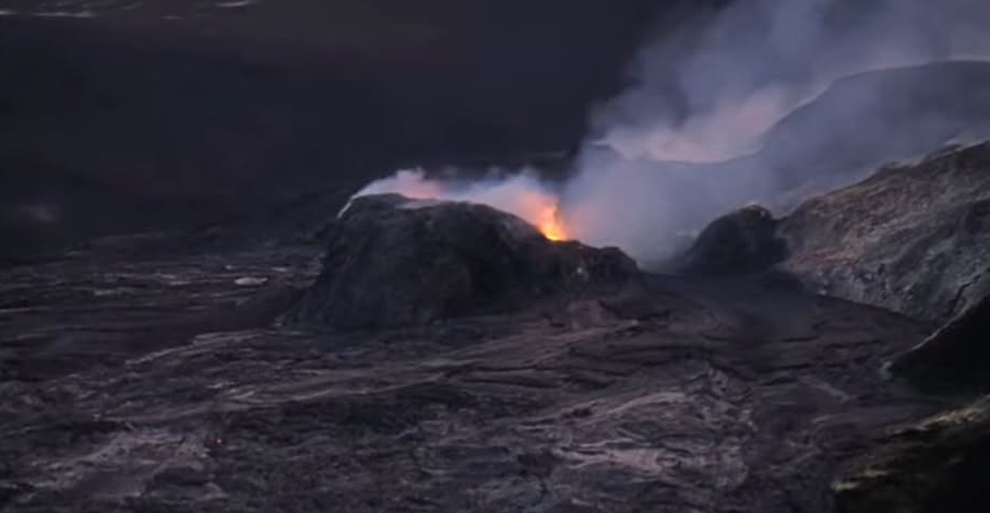
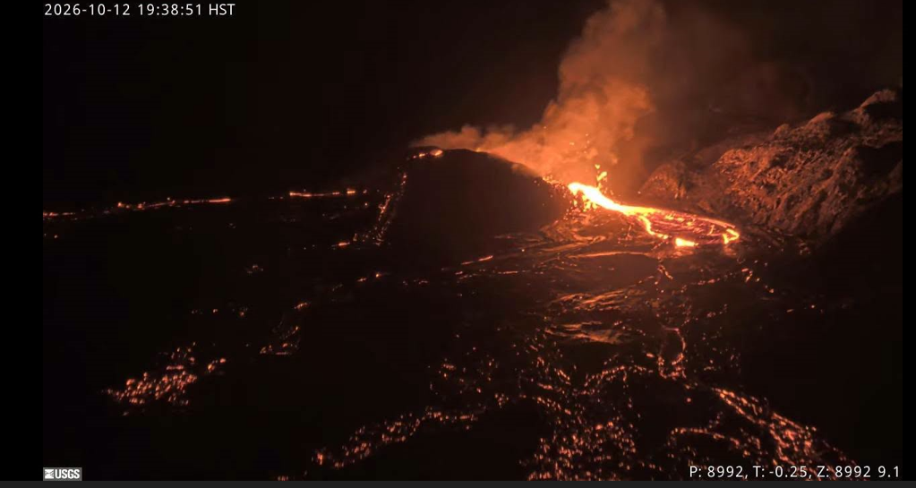
Multiple overflows and low fountaining occurred from the north vent over the past 24 hours. Kīlauea’s summit remains at a high level of pressurization with changes in eruptive activity or location within the summit region possible.
Summit Observations:
Just before 11:30 a.m. HST, the north vent began to vigorously dome fountain for nearly an hour feeding a flow that extended almost a kilometer from the vent. This was the longest and most vigorous dome fountain since September 30. There were two other substantial fountain and overflow episodes around 4 p.m. and 7 p.m. HST that lasted for about 40 minutes and 20 minutes respectively. Interspersed between and following these longer events were about 15 smaller events that lasted only a few minutes and produced flows less than 300 feet (100 meters) long. Sustained fountaining was followed by gas jetting often with sprays of spatter produced during drainback of lava within the vents. The last of these overflow events occurred around 9:30 p.m. HST and only glow with minor gas jetting and spatter were observed from the vents since then.
Summit tiltmeters showed slight tilt increases over the past 24 hours including at the Uēkahuna tiltmeter (UWD).
In the past 24 hours, there were 20 shallow earthquakes located across the summit region of Kīlauea, predominantly in the south caldera region. GPS stations on opposite sides of Halemaʻumaʻu (CRIM and UWEV) show a small increase in length since the end of September.
Updated interferometric synthetic aperture radar (InSAR) interferograms following the dike intrusion on September 30-October 1, show the intrusion has been slightly contracting since the evening of October 2. Minor intrusion-related motion was observed along many faults and cracks formed during the 2018 caldera collapse. There are no signs of significant deformation outside the caldera, including the south caldera region.
During inter-episode pauses, the sulfur dioxide (SO2) emission rate from the summit typically varies between 1,000 and 5,000 tonnes per day. Plumes of volcanic gas are visible from the vents in day-time webcam views. Winds are currently forecast from the east southeast then changing to from the east this evening.
Rift Zone Observations:
Rates of seismicity and ground deformation remain low in the East Rift Zone and Southwest Rift Zone. SO2 emissions from the East Rift Zone remain below the detection limit. No significant ground deformation was recorded in either rift zone.
Source et photo : HVO.
Italy / Sicily , Etna :
WEEKLY BULLETIN, October 5, 2026 to October 11, 2026 (issue date: October 13, 2026)
SUMMARY OF ACTIVITY STATUS
Based on monitoring data, the following is observed:
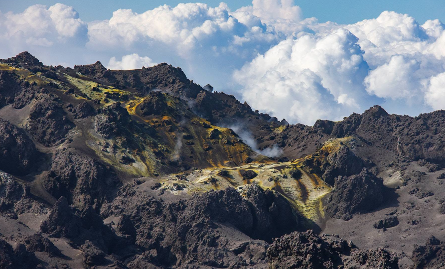
1) VOLCANOLOGICAL OBSERVATIONS: Variable degassing activity at the summit craters and intermittent ash emissions from the Northeast Crater.
2) SEISMOLOGY: Low fracturing-related seismic activity. Average volcanic tremor amplitude at a low level.
3) INFRASOUND: Low infrasonic activity.
4) GROUND DEFORMATION: Time series from ground deformation monitoring stations show no significant variations.
5) GEOCHEMISTRY: SO2 flux at a moderate level.
Soil CO2 flux (Etnagas): average values.
Partial pressure of dissolved CO2 in groundwater (EtnaAcque network): no update.
Helium isotope ratio at peripheral sites: the latest data from September 22, 2026, confirm high values.
6) SATELLITE OBSERVATIONS: Thermal activity observed by satellite in the summit area was generally low.
VOLCANOLOGICAL OBSERVATIONS
Monitoring of Etna’s volcanic activity during the week in question was conducted by analyzing images from the INGV-Osservatorio Etneo (INGV-OE) surveillance camera network. Poor weather conditions severely limited observations.
Activity at Etna’s summit craters remained unchanged compared to the previous bulletin (Report No. 41/2026 ETNA); it was characterized by sporadic, diffuse ash emissions, primarily from the North-East Crater. Overall, the summit craters mainly exhibited degassing of varying intensity.
Source : INGV
Photo : Giovinsky Aetnensis
Italy , Stromboli :
WEEKLY BULLETIN, October 5, 2026 – October 11, 2026 (issue date: October 13, 2026)
ACTIVITY SUMMARY
Based on monitoring data, the following is noted:
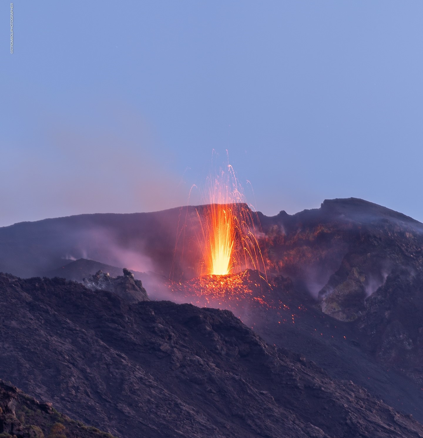
1) VOLCANOLOGICAL OBSERVATIONS: Ordinary Strombolian eruptive activity in both crater zones, accompanied by spattering in the North crater zone. Total explosive activity frequency (including North and Central-South crater zones) at a moderate level, with low explosion intensity in the North and Central-South crater zones. Lava overflow from the North crater zone on October 5 and 6.
2) SEISMOLOGY: Monitored seismic parameters show no significant variations.
3) GROUND DEFORMATION: No significant variations detected in the time series from ground deformation monitoring stations.
4) GEOCHEMISTRY: SO2 flux at a moderate level.
Soil CO2 flux (Pizzo zone – STR02): no update.
C/S ratio in the plume: no update.
Helium isotope ratio (R/Ra): no update.
Soil CO2 flux in the San Bartolo zone: moderate values.
Soil CO2 flux in the Scari zone: no update.
5) SATELLITE OBSERVATIONS: Thermal activity observed by satellite in the summit area ranged from low to moderate during the lava overflow episode on October 5, 2026.
VOLCANOLOGICAL OBSERVATIONS
Observations of explosive activity captured by surveillance cameras
During the observation week, Stromboli’s eruptive activity was characterized through the analysis of images recorded by INGV-OE surveillance cameras located at 190 m above sea level and at Punta dei Corvi (SCT-SCV and SPCT, respectively). Explosions in the North crater zone (Zone N) primarily produced coarse material (bombs and lapilli); in the Central-South crater zone (Zone CS), explosions produced predominantly fine material mixed with coarse material. The average explosion frequency in Zone N was within the normal range. In Zone CS, the average explosion frequency was at low-to-moderate levels. The total daily average hourly explosion frequency (Zone N + Zone CS) was at a moderate level. The intensity of explosive activity remained low in both crater zones.
UNUSUAL ACTIVITY
Effusive activity by lava overflow (times in UTC)
On October 5, an episode of lava overflow emission occurred from the North crater area, at vent N1. The event began at 13:05 and generated a modest lava flow that remained confined to the upper part of the Sciara del Fuoco, before ending at 22:50 on the same day. A second, short-lived episode took place on October 6, from approximately 07:25 to approximately 08:40.
Source : INGV
Photo : Stromboli stati d’animo / Sebastiano Cannavo
Colombia , Puracé – Los Coconucos volcanic chain. :
Popayán, October 13, 2026, 4:20 PM.
As part of the monitoring of activity at the Puracé volcano—part of the Los Coconucos volcanic chain (CVLC)—the Colombian Geological Service (SGC), an agency attached to the Ministry of Mines and Energy, reports the following:
During the week of October 6 to 12, 2026, there was a slight increase in the number of seismic events associated with fluid movement (gases and liquids originating from magma and its interaction with the hydrothermal system). These events continued to be located primarily beneath the Puracé volcano crater, at depths of less than 2 km.
Seismicity associated with rock fracturing (VT) remained at levels similar to those recorded the previous week in terms of the number of events; these were located northeast of the volcano, at distances of 12 to 16 km and depths of 8 to 14 km. Notably, a magnitude 1.9 ML event was recorded. Additionally, events of low magnitude were located at depths of 1 to 4 km in the area where the flanks of the Puracé and Piocollo volcanoes meet.
Slow ground deformation continues in the sector situated between the Puracé, Piocollo, and Curiquinga volcanoes. Furthermore, significant levels of sulfur dioxide (SO₂) and carbon dioxide (CO₂) emissions into the atmosphere continue to be recorded, with daily mass emissions reaching up to 250 tonnes and concentrations of up to 800 parts per million, respectively. Satellite observations made it possible to identify low-energy thermal anomalies within the crater itself during this period.
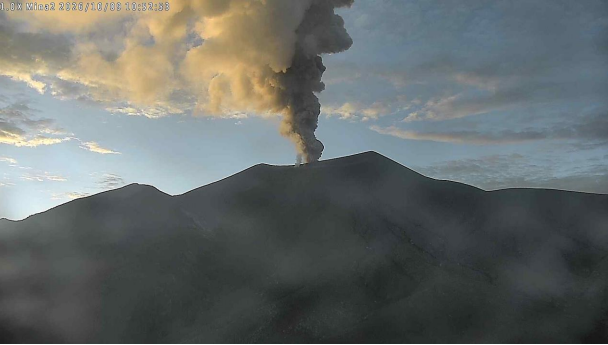
Emission event at Puracé Volcano on October 9, 2026, at 05:52. Recording from the Mina2 camera, located 2.2 km northwest of Puracé Volcano.
Thirty-nine ash emission events were recorded, reaching altitudes exceeding two (2) kilometers above the volcano’s summit; continuous degassing was also observed. Dispersion occurred primarily toward the northwest and west of the volcano. Reports of these emissions were received from residents of Coconuco, Puracé, Paletará, and certain hamlets in the municipality of Sotará.
In conclusion, the variations observed at Puracé Volcano (CVLC) indicate that the system continues to exhibit instability across several monitored parameters; ongoing ash emissions and fallout, dispersed according to prevailing wind directions, are possible. Likewise, the emergence of new changes in volcanic activity—potentially leading to more energetic surface manifestations—cannot be ruled out.
The volcanic alert level remains at « Yellow »: active volcano showing changes in the baseline behavior of monitored parameters and other manifestations.
Source et photo : SGC.