October 4 , 2026.
United-States , Yellowstone :
YELLOWSTONE VOLCANO OBSERVATORY MONTHLY UPDATE , U.S. Geological Survey
Thursday, October 1, 2026, 9:10 AM MDT (Thursday, October 1, 2026, 15:10 UTC)
44°25’48 » N 110°40’12 » W,
Summit Elevation 9203 ft (2805 m)
Current Volcano Alert Level: NORMAL
Current Aviation Color Code: GREEN
Summary:
YVO Monthly Update: background seismicity and deformation, small hydrothermal explosion at Biscuit Basin
Yellowstone Caldera activity remains at background levels, with 77 located earthquakes in September (largest = M3.4). Deformation measurements indicate no significant uplift or subsidence of the caldera or north caldera rim for the past several months. A small hydrothermal explosion occurred at Biscuit Basin on September 27.
Recent Work and News
Yellowstone Volcano Observatory scientists spent September in the park conducting geological research, setting up new monitoring stations, and maintaining existing monitoring equipment. This work included studies of Lower Geyser Basin hydrothermal activity and lakes, recovery of temporary GPS stations, microgravity measurements, maintenance of temperature monitoring stations, establishing a new hydrothermal monitoring station in Upper Geyser Basin, and reestablishing a camera with a view of Yellowstone Lake.
Although there were only sporadic minor eruptions from Steamboat Geyser, in Norris Geyser Basin, during the month (and only 1 major eruption so far in 2026), nearby Echinus Geyser had an eruption on September 15, continuing a trend of occasional eruptions that has persisted throughout most of the year. In Upper Geyser Basin, Giant Geyser (the second tallest geyser in Yellowstone National Park) erupted on September 10 and 22, its fourth and fifth eruptions of the year. The geyser appears to be in a new stage of frequent activity for the first time since 2018–2019.
Thermal features in Biscuit Basin, in the Upper Geyser Basin not far from Old Faithful Geyser, remained active in September. Black Diamond Pool, which was the site of a hydrothermal explosion on July 23, 2024, had several eruptions during the latter half of the month, including one large event that sent water and mud tens of feet (many meters) into the air on the night of September 23. In addition, the small pool of hot water that formed via collapse after the June 13, 2026, hydrothermal explosion erupted multiple times on September 24 and 27. Just after 8:12 PM MDT on September 27, the pool was the source of a hydrothermal explosion that threw boiling water, steam, mud, and rocks at least 100 feet (30 meters) into the air—the first such significant explosion from this feature. The event was well recorded by a nearby seismic, acoustic, and camera monitoring station.
Seismicity
During September 2026, the University of Utah Seismograph Stations, responsible for the operation and analysis of the Yellowstone Seismic Network, located 77 earthquakes in the Yellowstone National Park region. The largest event of the month was a minor earthquake of magnitude 3.4 located about 20 miles northeast of Moran, WY, on September 6 at 10:25 p.m. MDT.
September seismicity in Yellowstone was marked by a small swarm of 24 earthquakes located about 7 miles north-northwest of West Yellowstone, MT, on September 8. The magnitudes ranged from -0.1 to 2.8.
Earthquake activity in Yellowstone is at background levels.
Ground Deformation
Data from continuous GPS stations indicate little net deformation of the caldera or north caldera regions over the past several months. Subtle variations in ground motion are probably caused by seasonal variations associated with groundwater conditions as summer transitions to fall.
Source : YVO.
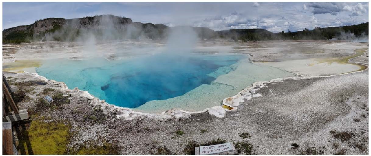
Photo : Sapphire Pool , YVO
Hawaii , Kilauea :
HAWAIIAN VOLCANO OBSERVATORY DAILY UPDATE , U.S. Geological Survey
Friday, October 2, 2026, 9:45 AM HST (Friday, October 2, 2026, 19:45 UTC)
19°25’16 » N 155°17’13 » W,
Summit Elevation 4091 ft (1247 m)
Current Volcano Alert Level: WATCH
Current Aviation Color Code: ORANGE
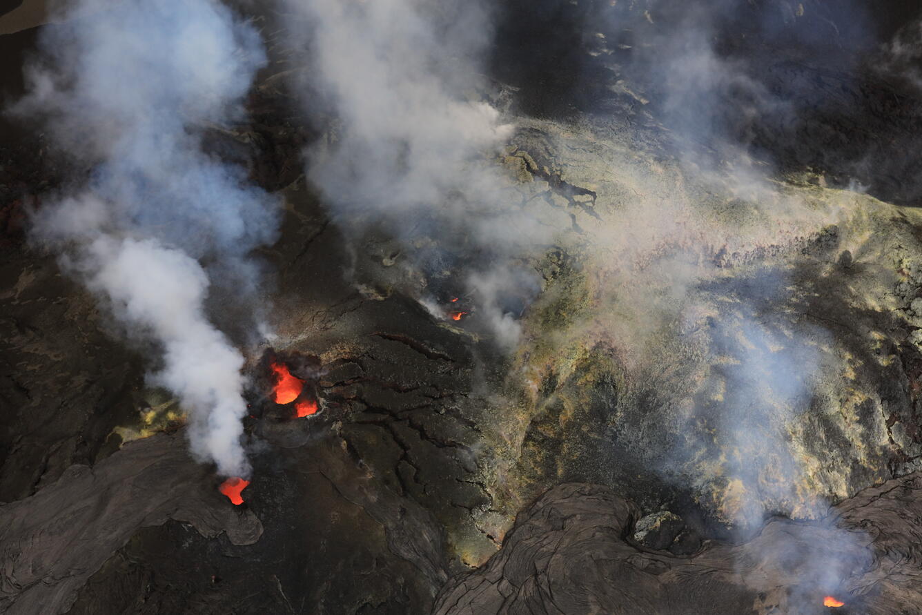
Aerial view of the north (bottom right of the photo), south (left side), and west (upper middle) vents in Halema‘uma‘u at the summit of Kīlauea on the morning of October 1, 2026. All three vents were strongly glowing during the overflight, with lava seen at about 100 ft (30 m) down in the vent conduit.
Summary:
No overflows or spattering at north or south vents over the past day; strong glow and flames continue. No reactivation of intrusion emplaced two nights ago. Earthquake activity continues underneath Halemaʻumaʻu. No anomalous activity outside the summit.
Overview:
There have been no overflows or spatter from north or vents in the past 24 hours, although there was strong glow and flames from the vents overnight. The summit intrusion that happened the night of September 30 to October 1 did not reactive in the last 24 hours, although earthquake activity has continued underneath Halemaʻumaʻu. A summit tiltmeter near Uēkahuna also recorded modest inflation.
Episode 55 fountaining remains a possibility during the ongoing Kīlauea summit eruption. It is also possible that intrusive activity below Kīlauea summit caldera could resume and potentially lead to the eruption of lava in a new location within the caldera.
Summit Observations:
In the past 24 hours, there have been no overflows and no spattering. Both vents had strong glow with flaming overnight. No other areas of incandescence were observed across the summit region last night. Overflows from the north and south vents stopped during the early stages of the intrusion that started underneath Kaluapele, Kīlauea summit caldera, the afternoon of September 30, but resumed later on during the intrusion. The intrusion ended on October 1 at around 4 a.m. H.S.T. South vent only had one overflow after the intrusion, ending just before 6 a.m. yesterday October 1, and north vent’s last overflow was just after 6 a.m. HST yesterday morning.
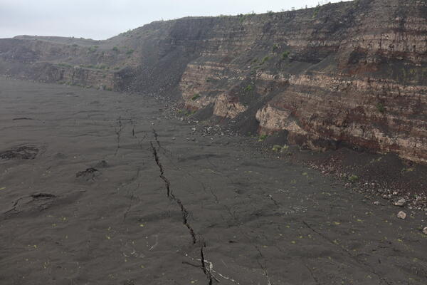
Following the seismic swarm and tilt excursion associated with an intrusion over the night of September 30 to October 1, USGS Hawaiian Volcano Observatory staff undertook a helicopter overflight to assess any changes on the upper caldera floor of Kaluapele and the crater floor of Halemaʻumaʻu. The northern part of the caldera floor of Kaluapele hosts numerous cracks that have been present since the 2018 caldera collapse and some have existed for even longer. During the overflight, no new cracks were observed, and significant widening of the already existing cracks was not apparent.
Elevated rates of earthquakes below Kaluapele, continue following the intrusion. In the past 24 hours, there were 59 shallow earthquakes located across the summit region, primarily underneath Halemaʻumaʻu. The largest earthquake was a magnitude 3.5 earthquake at 7:55 a.m. H.S.T. this morning, October 2. Additionally, over the past 24 hours, the Uēkahuna tiltmeter (UWD) recorded approximately 4.9 microradians of inflation. A helicopter overflight yesterday morning, after the end of intrusive activity, did not find evidence of new ground cracking or eruption of lava in a new location.
During inter-episode pauses, the sulfur dioxide (SO2) emission rate from the summit typically varies between 1,000 and 5,000 tonnes per day. Winds are currently forecast from the east.
Rift Zone Observations:
Rates of seismicity and ground deformation remain low in the East Rift Zone and Southwest Rift Zone. SO2 emissions from the East Rift Zone remain below the detection limit. No significant ground deformation was recorded in either rift zone.
Source : HVO.
Photos : USGS / D. Downs.
Martinique , Mount Pelée :
Weekly Report, Institut de physique du globe de Paris / Martinique Volcanological and Seismological Observatory (OVSM)
Saint-Pierre, October 2, 2026, at 16:00 local time (GMT-4)
Volcano-tectonic seismic activity
Between September 25, 2026, at 16:00 (UTC) and October 2, 2026, at 16:00 (UTC), the OVSM recorded 226 volcano-tectonic earthquakes:
– 226 volcano-tectonic earthquakes. Nine earthquakes had a magnitude (local magnitude Mlv or duration magnitude Md) greater than 1. The largest had a magnitude of Mlv = 1.78; the others were of lower energy. These earthquakes were located at depths ranging from 0.7 to 4 km beneath the volcano’s summit.
No earthquakes were reported felt by the population.
During the previous week, the OVSM had recorded 198 volcano-tectonic earthquakes. As of October 2, 2026, and over the past four weeks, the OVSM has thus observed a total of 706 volcanic earthquakes, representing an average of 176 to 177 earthquakes per week.
Deformations of Mount Pelée
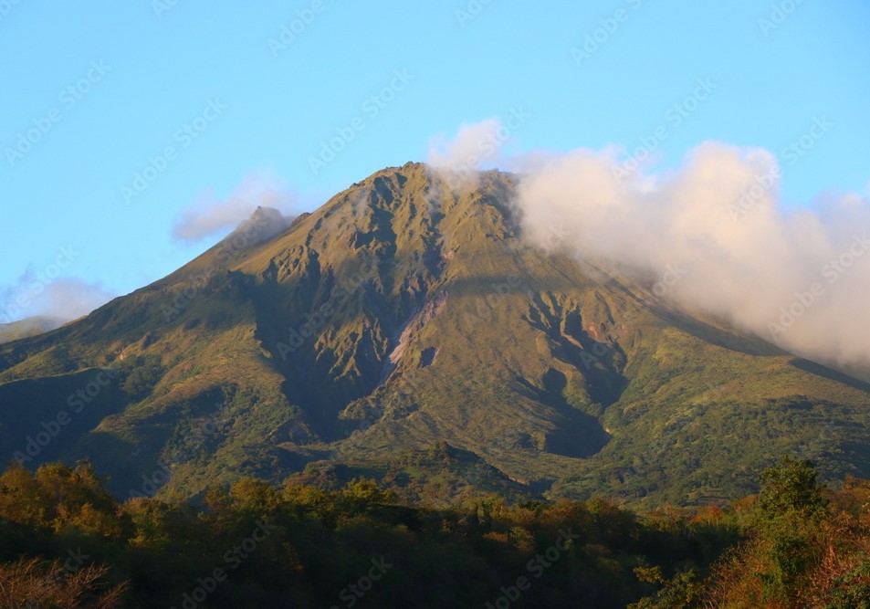
Since May 2026, the OVSM has been recording ground displacements of several centimeters in the summit area of Mount Pelée. In the deformation zones near the summit, the maximum extension recorded over the past four weeks is 1.1 cm (along an 880-meter-long profile). These displacements are consistent with deformation of the volcanic edifice caused by an inflating pressure source located at a depth of approximately 1 km beneath the summit.
The probability of short-term eruptive activity remains low. However, given the observations gathered over recent months and years, a change in the situation over the medium term (weeks to months) cannot be ruled out.
The volcanic alert level, in accordance with the measures established by the authorities, is currently YELLOW: vigilance.
Source et photo : Direction de l’OVSM-IPGP
Costa Rica , Poas :
Latitude: 10.20° N;
Longitude: 84.23° W;
Elevation: 2,687 m above sea level.
Current activity level: Advisory
No eruptions were recorded this week. Although tremor amplitude remains generally moderate and stable, variations in spectral content continue to be observed, ranging from monochromatic to broadband spectra. A low-magnitude, distal volcano-tectonic earthquake was recorded this week. The number of long-period events has decreased. Over the medium term (6 months), a trend of subsidence and contraction of the volcanic edifice is observed. In the short term, no significant deformation is being recorded. Multi-GAS stations measured an SO2/CO2 ratio of 0.8 ± 0.4, a value lower than that of the previous week (1.2 ± 0.5).
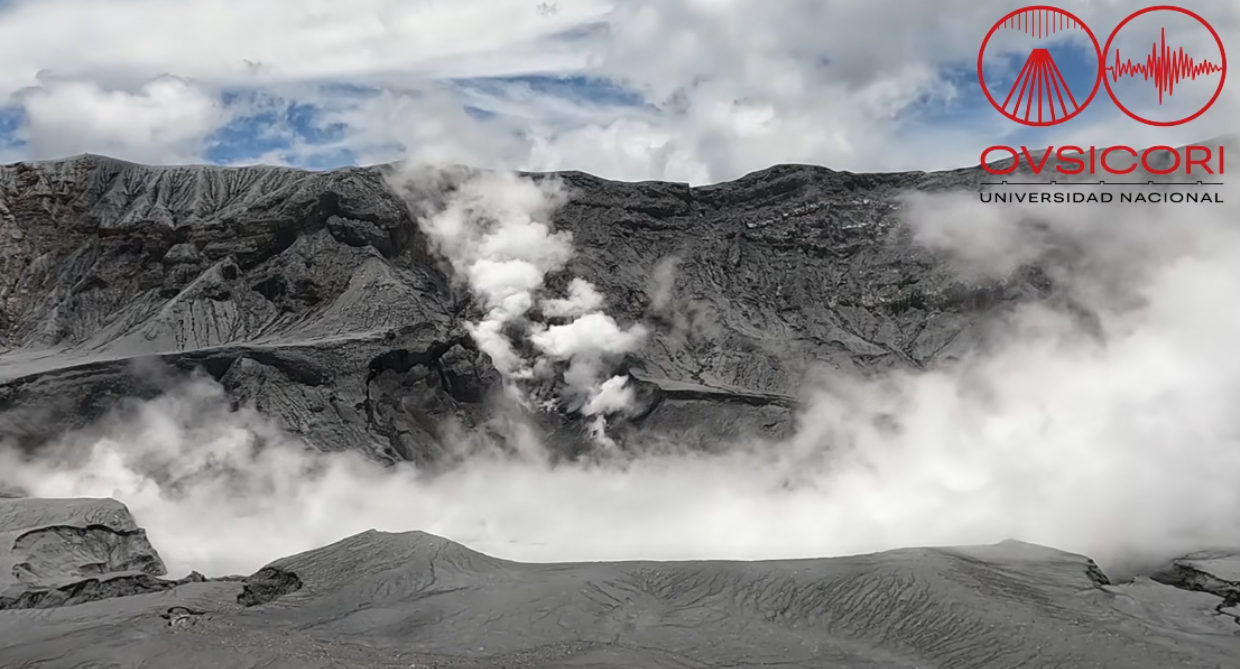
The H2S/SO2 ratio remains below 0.1. NOVAC stations recorded an average daily SO2 emission of 77 ± 88 tonnes, with a maximum of 682 t/d. This flux is lower than that of the previous week (130 ± 95 t/d, with a maximum of 1,287 t/d); however, this apparent decrease could be due to wind direction being unfavorable for measurements this week. The Sentinel satellite detected the SO2 plume daily, with an average value slightly below 100 tonnes and a peak of 358 tonnes of SO2 in the atmosphere on September 30. The lake level rose slightly this week. The lake temperature remains very high (>60°C, remote measurement)..
Source et photo : Ovsicori.
Ecuador , El Reventador :
DAILY STATUS REPORT FOR REVENTADOR VOLCANO, Saturday, October 3, 2026.
Information from the Geophysical Institute – EPN.
Surface activity level: High | Surface trend: Unchanged
Internal activity level: Moderate | Internal trend: Unchanged
From October 2, 2026, 11:00 AM to October 3, 2026, 11:00 AM:
Seismicity:
Explosion (EXP): 110
Long-period (LP): 14
Emission tremor (TREMI): 8
Harmonic tremor (TRARM): 4
Precipitation / Lahars:
No precipitation was recorded in the area. **Heavy rains could remobilize accumulated material and generate debris-laden mudflows (lahars) capable of descending the volcano’s flanks and flowing into adjacent rivers.**
Emission plume / ash:
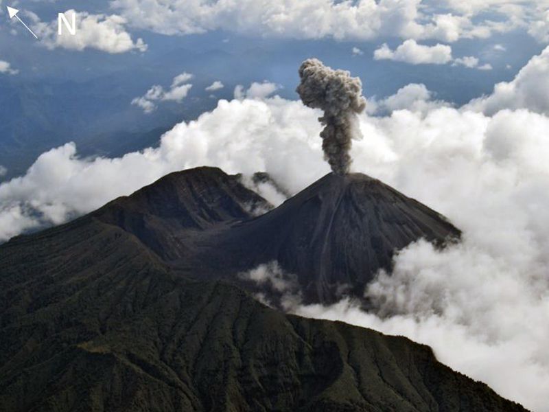
The surveillance camera system recorded an emission of gas and ash reaching a height of 500 meters above the crater rim, drifting southwest. In connection with this activity, the Washington VAAC issued a report noting an ash emission rising 700 meters above the crater rim, drifting west-northwest.
Gas:
The MOUNTS satellite system detected 5.8 tonnes of sulfur dioxide (SO2), measured yesterday at 13:19 (local time).
Observation:
From yesterday afternoon until the time of this report, the volcano remained largely obscured by clouds. However, during the night and early this morning, the surveillance camera system captured the descent of incandescent material to a point 1,100 meters below the crater rim.
Alert Level – SGR: Orange
Source : IGEPN.
Photo : f-naranjo , GVP.