May 14 , 2026.
Hawai , Kilauea :
HVO/USGS Volcanic Activity Notice
Current Volcano Alert Level: WATCH
Previous Volcano Alert Level: ADVISORY
Current Aviation Color Code: ORANGE
Previous Aviation Color Code: YELLOW
Issued: Wednesday, May 13, 2026, 8:45 AM HST
Source: Hawaiian Volcano Observatory
Notice Number: 2026/H221
Location: N 19 deg 25 min W 155 deg 17 min
Elevation: 4091 ft (1247 m)
Area: Hawaii
Summary:
Episode 47 lava fountaining is forecast to begin today or tomorrow based upon geophysical data. Because an eruption is imminent, HVO is raising the Alert Level for Kīlauea from ADVISORY to WATCH and the Aviation Color Code from YELLOW to ORANGE
Volcanic Activity:
Episode 47 lava fountaining is forecast to begin today or tomorrow based upon geophysical data. Additionally, webcam observations of small spatter bursts indicate that lava is close to the surface in the eruptive vents. Because an eruption is imminent, HVO is raising the Alert Level for Kīlauea from ADVISORY to WATCH and the Aviation Color Code from YELLOW to ORANGE.
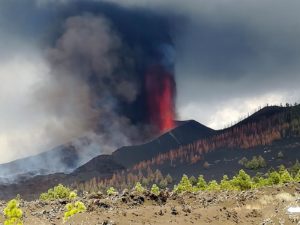
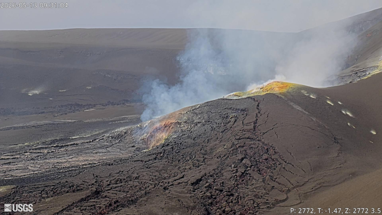
On May 12, 2026, a USGS Hawaiian Volcano Observatory helicopter overflight around Halema‘uma‘u crater flew past the Kīlauea summit eruptive vents to the southwest, offering a rarely seen view of the vents from the crater wall side. Large patches of sulfur minerals (yellow and brown) have formed in the tephra deposits on this side of the vents. Incandescence can be seen in the south vent from this angle, but the helicopter crew reported seeing lava ponds at shallow levels in both the north and south vents during the flight. The silvery lava flows stretching into the crater from the eruptive vents are remnants of recent eruptive episodes, as there have not yet been any overflows in advance of lava fountaining episode 47.
Wednesday, May 13, 2026, 9:00 AM HST (Wednesday, May 13, 2026, 7:00 PM UTC)
Overview:
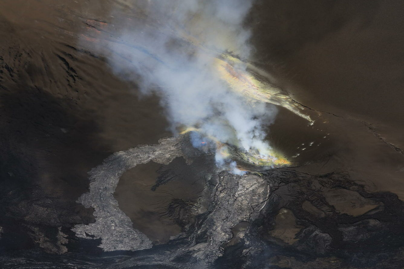
The Halemaʻumaʻu eruption at the summit of Kīlauea is currently paused. Consistent degassing continues from both eruptive vents. Overnight, the south vent had strong glow with periodic flaming, while the north vent had slightly weaker glow with several small spatter bursts. Based on current tilt data, the forecast window for lava fountaining episode 47 is sometime between today, May 13 and tomorrow, May 14; this window may be adjusted based on continuing observations. The episode could start at any time now, though accelerated precursory activity—overflows and more vigorous spattering—is expected to precede lava fountaining.
Summit Observations:
Overnight webcam views showed strong glow and periodic flaming at the Halemaʻumaʻu south vent, likely caused by the ignition of volcanic gases escaping the vent. Slightly weaker glow and several small spatter bursts were seen at the north vent. Degassing continues from both the vents and the surrounding area in the western part of Halemaʻumaʻu crater. During a helicopter overflight on Tuesday morning, May 12, Hawaiian Volcano Observatory scientists observed lava ponds at shallow levels in both eruptive vents.
Steady seismic tremor continues, without the tremor bursts that have been detected during pauses between prior lava fountaining episodes. Earthquake activity at the summit during and after episode 46 has been low.
Steady summit inflation continues; since the end of lava fountaining episode 46, the Uēkahuna tiltmeter (UWD) has recorded approximately 14.1 microradians of inflationary tilt. This same instrument recorded about 14.0 microradians of deflationary tilt during episode 46.
With the eruption now paused, the sulfur dioxide (SO2) emission rate is likely now varying within a typical range of 1,000 to 5,000 tonnes per day. Measurements conducted during yesterday morning’s helicopter flight indicated an emission rate of 2,600 tonnes per day at the time, within the expected range. Current summit wind conditions are moderate from the north-northeast, carrying the volcanic gas plume to the southwest.
Rift Zone Observations:
Rates of seismicity and ground deformation remain low in the East Rift Zone and Southwest Rift Zone. SO2 emissions from the East Rift Zone remain below the detection limit.
Source : HVO.
Photos : USGS / P. Dotray , USGS.
Alaska , Kupreanof :
AVO/USGS Volcanic Activity Notice
Current Volcano Alert Level: ADVISORY
Previous Volcano Alert Level: UNASSIGNED
Current Aviation Color Code: YELLOW
Previous Aviation Color Code: UNASSIGNED
Issued: Tuesday, May 12, 2026, 9:01 AM AKDT
Source: Alaska Volcano Observatory
Notice Number: 2026/A322
Location: N 56 deg W 159 deg 47 min
Elevation: 6217 ft (1895 m)
Area: Alaska Peninsula
Summary:
Seismic activity and volcanic gas emissions increased over the past few months and continue at Mount Kupreanof. AVO is increasing the Color Code and Alert Level to YELLOW/ADVISORY.
Volcanic Activity:
Seismic activity and volcanic gas emissions increased over the past few months and now continue at elevated levels at Mount Kupreanof. This activity is likely caused by a magmatic intrusion beneath the volcano. The Alaska Volcano Observatory (AVO) is therefore increasing the Aviation Color Code to YELLOW and the Volcano Alert Level to ADVISORY in response to this sustained volcanic unrest.
Summary of activity and hazards
Seismicity was first detected in February 2026 and has increased in recent months, with earthquakes as large as magnitude 3.1 detected.
Sulfur dioxide (SO2) emissions were detected beginning on April 4 with emission rates of ~100 to 1,000 tons per day, which are well above the background rate of <100 tons per day.
These signals likely indicate a magmatic intrusion beneath Mount Kupreanof.
AVO is therefore increasing the Aviation Color Code to YELLOW and the Volcano Alert Level to ADVISORY in response to this sustained volcanic unrest.
Data do not suggest an eruption is imminent and further signs of increased unrest would be expected prior to eruption.
There is no local monitoring network at Mount Kupreanof. Seismicity is detected using only regional stations, which limits detection of smaller events (magnitudes <2) and results in large location errors.
Remarks:
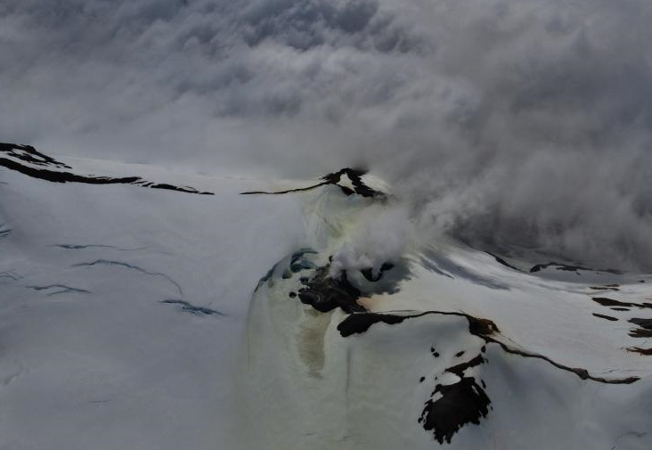
Mount Kupreanof is a heavily glaciated stratovolcano on the Alaska Peninsula with no known historical eruptions. Very little is known about its eruptive history. A single debris flow or block-and-ash flow deposit with a suspected Holocene age has been mapped in a valley south of the volcano. Eruptions will likely produce lahars and pyroclastic flows on the volcano’s flanks and into the surrounding uninhabited valleys. Ash plumes could affect communities and airplanes downwind of the volcano. A vigorous fumarole field just west of the summit produces persistent steam plumes.
There is no real-time geophysical monitoring network at Mount Kupreanof. The closest functioning seismometers are approximately 17 miles (27 km) to the east of the volcano as part of the Mount Veniaminof network. Mount Kupreanof is also monitored by satellite data, remote infrasound and lightning networks, and visual observations from pilots and mariners passing by the volcano.
Source : AVO.
Photo : Read, Cyrus / AVO/USGS.
Kamchatka , Bezymianny :
KVERT VOLCANIC ACTIVITY NOTICE (VAN)
Issued: May 13 , 2026
Volcano: Bezymianny (CAVW #300250)
Current aviation colour code: ORANGE
Previous aviation colour code: yellow
Source: KVERT
Notice Number: 2026-40
Volcano Location: N 55 deg 58 min E 160 deg 36 min
Area: Kamchatka, Russia
Summit Elevation: 2882 m (9452.96 ft)
Volcanic Activity Summary:
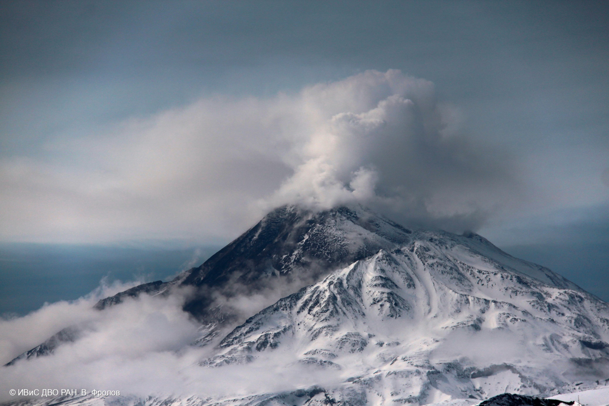
An activity of the volcano has increased, hot avalanches are observed on the slopes, and the temperature of the thermal anomaly has increased during last day. A gas-steam plume with ash extended about 80 km to the south-west from the volcano.
An extrusive eruption of the volcano continues. Ash explosions up to 15 km (49,200 ft) a.s.l. could occur during several days. Ongoing activity could affect international and low-flying aircraft.
Volcanic cloud height:
4000 m (13120 ft) AMSL Time and method of ash plume/cloud height determination: 20260513/2200Z – Himawari-9 14m15
Other volcanic cloud information:
Distance of ash plume/cloud of the volcano: 80 km (50 mi)
Direction of drift of ash plume/cloud of the volcano: WSW / azimuth 241 deg
Time and method of ash plume/cloud determination: 20260513/2200Z – Himawari-9 14m15
Source : Kvert.
Photo : V. Frolov. IVS FEB RAS ( archive).
Indonesia , Dukono :
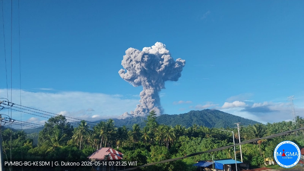
An eruption of Mount Dukono occurred on Thursday, May 14, 2026, at 07:12 WIT, with an observed ash column height of approximately 3,500 m above the summit (approximately 4,587 m above sea level). This ash column, white to gray in color, was highly concentrated and directed northwest. At the time of writing, the eruption was still ongoing.
Seismic Observations
24 eruption earthquakes with amplitudes ranging from 7 to 34 mm and durations from 41.74 to 86.32 seconds.
One distant tectonic earthquake with an amplitude of 34 mm and a duration of 97.4 seconds.
Continuous tremor with an amplitude between 1 and 10 mm, predominantly 8 mm.
Recommendations
(1) Communities living near Mount Dukono and visitors/tourists are advised to refrain from any activity, climbing, or approaching the Malupang Warirang crater within a 4 km radius.
(2) Since eruptions with volcanic ash projection are periodic and the dispersion of ash depends on the direction and strength of the wind, making the coverage area unstable, communities near Mount Dukono are advised to always have masks/face coverings available to protect themselves from respiratory risks related to volcanic ash.
Source et photo : PVMBG.
Colombia , Chiles / Cerro Negro :
San Juan de Pasto, May 12, 2026, 3:30 PM
Regarding the monitoring of activity at the Chiles-Cerro Negro Volcanic Complex (CVCCN), the Colombian Geological Survey (SGC), an agency under the Ministry of Mines and Energy, reports the following:
For the period from May 5 to 11, 2026, the main variations in monitored parameters, compared to the previous week, were as follows:
● A significant decrease in the frequency and energy of earthquakes was observed. Earthquakes related to crustal fracturing processes in different areas of the volcanic edifices remained predominant. These events occurred in several sectors of the Chiles volcano collapse zone, to the south and east of this region, as well as between the two volcanoes, at depths ranging from 2 to 6 km below the summit of Chiles volcano (4,700 m above sea level). The largest of these events, with a magnitude of 2.9, was recorded on May 10 at 7:38 a.m., 1.5 km south-southeast of the summit of Chiles volcano, at a depth of 4.1 km. Its direction was not specified. Meanwhile, seismicity related to fluid movement continued to be recorded.
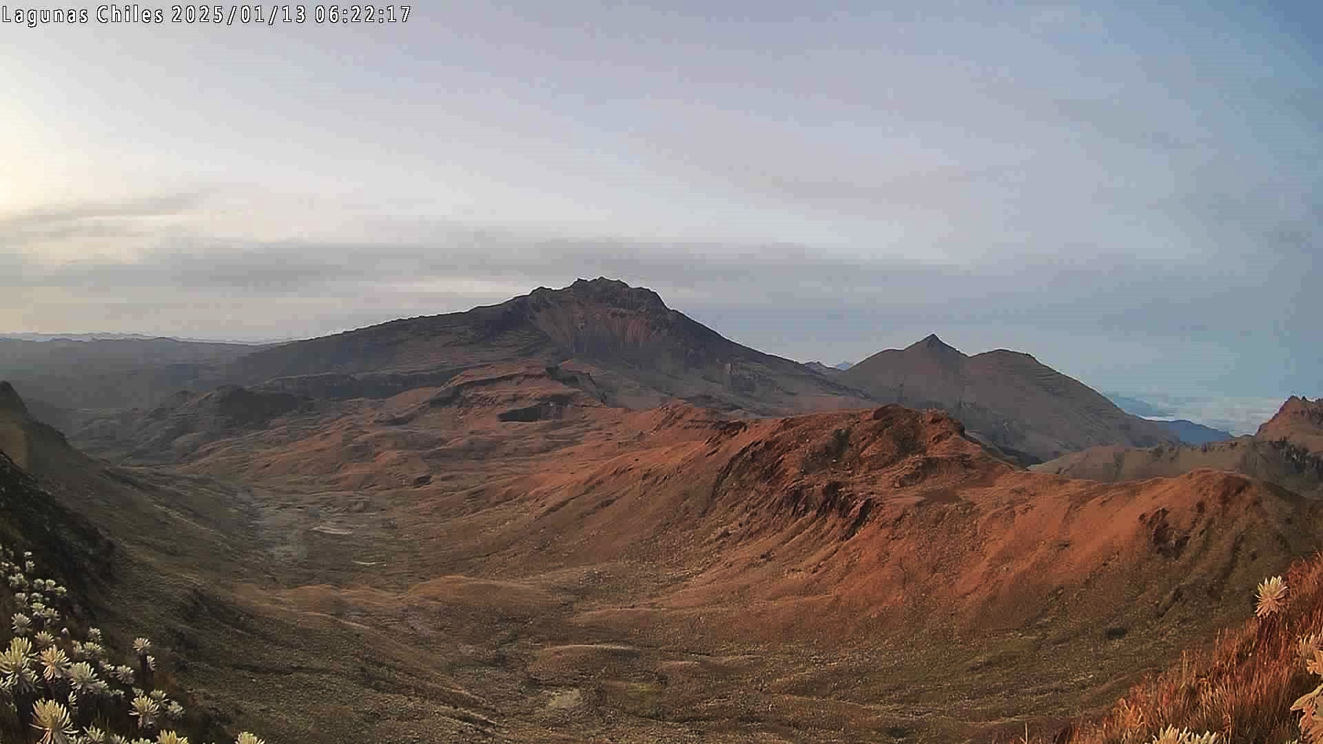
● Recording of volcanic deformation variations, measured by satellite sensors and ground stations in the area of influence of these volcanoes, continued.
● Following the assessment and correlation of monitored parameters, the Geological Survey of Colombia (SGC) recommends closely monitoring the evolving situation by consulting the weekly bulletins and other information disseminated through its official channels, as well as the instructions of local and departmental authorities and the National Unit for Disaster Risk Management (UNGRD).
Volcanic activity remains at the yellow alert level: active volcano exhibiting changes in the reference behavior of monitored parameters and other manifestations.
Source et photo : SGC.