April 29 , 2026.
Italy , Stromboli :
WEEKLY BULLETIN, April 20, 2026 to April 26, 2026. (Issuance date: April 28, 2026)
ACTIVITY SUMMARY
Based on monitoring data, the following points should be noted:
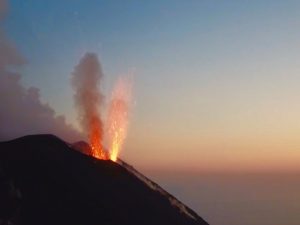
1) VOLCANOLOGICAL OBSERVATIONS: During this period, ordinary Strombolian-type eruptive activity was observed, interrupted by ejecta and two lava flows from the North Crater area. The total hourly frequency fluctuated between average (8 events/h) and high (23 events/h).
The intensity of the explosions was mainly low to medium in the North and Central-South Crater areas.
2) SEISMOLOGY: The monitored seismic parameters did not show any significant variations.
3) GROUND DEFORMATION: No significant changes are detected in the GNSS time series.
The tilt network is not operational.
4) GEOCHEMISTRY: SO₂ fluxes are medium to high.
CO₂ fluxes from the soil in the Pizzo area (STR02): average values (approximately 6,000 g/m²/day).
C/S ratio in the plume: no update available last week.
Helium isotope ratio (R/Ra) dissolved in the thermal aquifer: data from the last sample, taken on March 23, 2026, indicate high values (R/Ra = 4.50).
CO₂ fluxes from the soil in the San Bartolo area: high values.
CO₂ fluxes from the soil in the Scari area: average values.
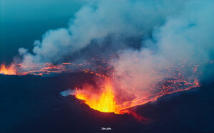
5) SATELLITE OBSERVATIONS: Satellite-observed thermal activity in the summit area was generally moderate, with high values corresponding to effusive episodes. The first began on April 21 and ended on April 22, 2026, while the second occurred between April 23 and 24, 2026.
6) OTHER OBSERVATIONS: Northern Zone: Projectile activity with a gas composition consistent with this type of activity.
Central-Southern Zone: Quiet degassing with a higher than normal SO₂/HCl ratio and explosive events with a greater CO₂ contribution.
VOLCANOLOGICAL OBSERVATIONS
During the observation period, Stromboli’s eruptive activity was characterized by the analysis of images recorded by the INGV-OE monitoring cameras located at 190 m (SCT-SCV) and at Punta dei Corvi (SPCT). Explosive activity was primarily produced by five eruptive vents located in the northern crater area and by at least two vents located in the central-southern area.
On April 21 and 22, a lava flow was observed in the northern crater area, while on April 23 and 24, an overflow was observed in the same area.
Observations of explosive activity captured by monitoring cameras
In the northern (N) crater area, five active vents were observed: two in sector N1 and three in sector N2. These vents produced explosive activity ranging from low (less than 80 m high) to medium intensity (less than 150 m high). Ejections of material were also observed at the vents in sector N2. The eruptive products were primarily coarse material (bombs and lapilli). The average frequency of explosions varied between 3 and 14 events per hour.
In the Central-South (CS) crater area, two main vents were observed. These vents produced explosions of coarse material, sometimes mixed with fine material, ranging from low to medium intensity. The average frequency of explosions varied between 4 and 9 events per hour.
Field observations, sampling, and FTIR measurements at the crater summit on April 21, 2026
On April 21, an inspection of the summit was conducted by INGV staff between 1:00 PM and 5:00 PM local time. During this visit, they directly observed the eruptive activity, collected fresh samples, and performed FTIR spectroscopic measurements.
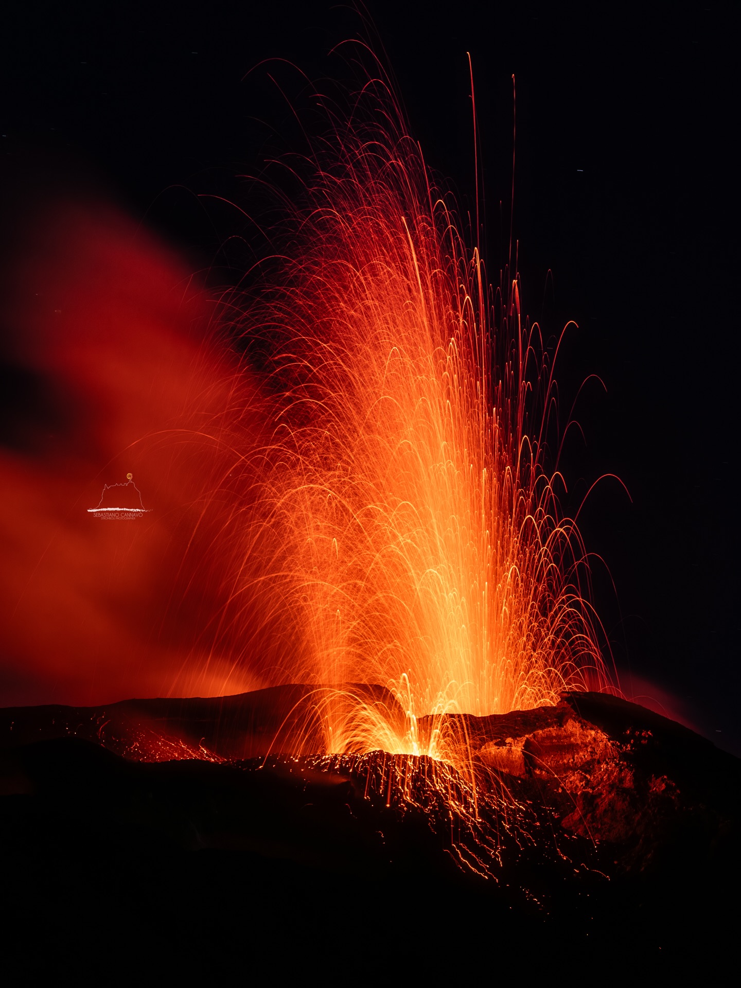
From Pizzo sopra La Fossa, the Central-South (CS) crater area presented a wide and deep morpho-structural depression containing at least three vents. The main vent (S1), characterized by a scoria accretion apparatus, produced sustained Strombolian activity, with eruptions exceeding 150 m in height and the fallout of clasts several decimeters in size within the crater terrace. Samples of scoriaceous lapilli associated with this activity were collected near the Pizzo. The two other vents, located respectively near the Sciara del Fuoco and the Pizzo (S3), exhibited intermittent activity, with weak explosions associated with ash emissions or prolonged jets of pressurized gas.
Near the northern area of the crater, a small cone was active in the N2 sector, alternating weak ejection activity with Strombolian explosions. In the N1 sector, a vent initially exhibited intense ash emissions associated with violent jets of magma fragments, gradually evolving, during the study, into effusive activity with the emission of a lava flow on the upper part of the Sciara del Fuoco.
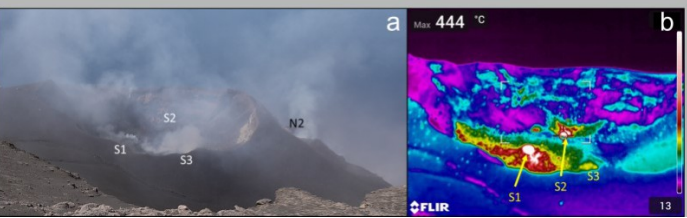
Images acquired on April 21, 2026, in the summit area. a) The crater terrace as seen from Pizzo sopra La Fossa; b) Thermal image of the South-Central crater area only.
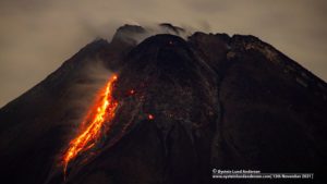
Lava flow of April 21–22, 2026
In the early afternoon of April 21, 2026, a lava flow began from a fracture at the base of the vent cone in sector N1 of the North (N) crater area. Due to the off-center positioning of the monitoring cameras, it was not possible to observe the vent or the lava flow. Information and infrared images of this effusive event were provided by INGV research staff present at the summit and are described in the field observations in the preceding paragraph. The lava flow quickly reached the upper-middle section of the Sciara del Fuoco, forming numerous lava sheets. By early afternoon on April 22, the lava flow appeared to be slowly feeding and cooling.
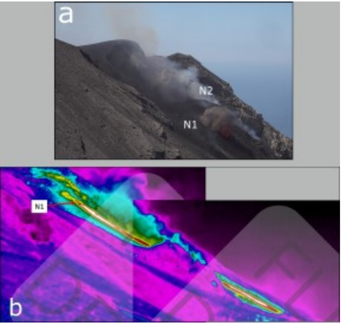
Photo of the North Crater area taken from shelters at an altitude of 800 m, b) the lava flow emitted on the afternoon of April 21 from the vent in sector N1. The red arrow indicates the point of emission and the bright streak indicates the lava flow.
Lava overflow of April 23 and 24, 2026.
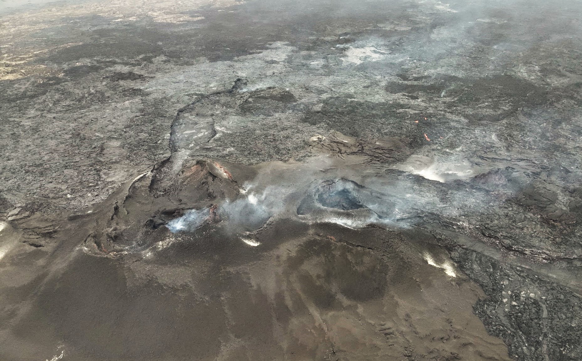
On April 23, a lava overflow occurred from the South vent in sector N2, overlooking the Sciara del Fuoco, in the North Crater area (N). The following is a description of this effusive event.
Starting at 16:12 UTC on April 23, large blocks of incandescent material began rolling down the upper part of the Sciara del Fuoco, quickly transforming into a lava flow. In the early hours of April 24, the flow appeared to be slowly being fed and cooling.
Source : INGV.
Photos : Stromboli stati d’animo / Sebastiano Cannavo , INGV.
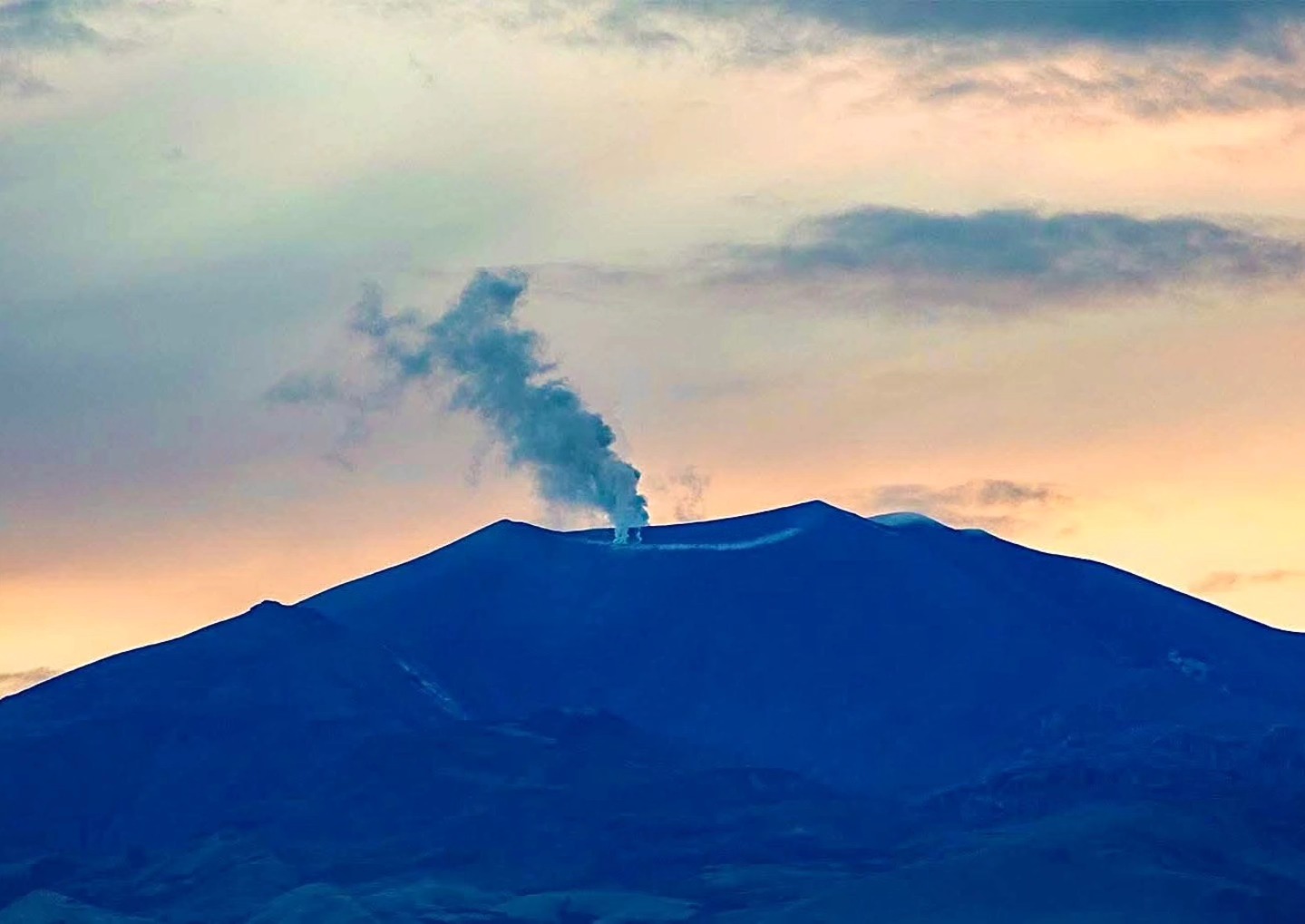
Iceland , Reykjanes Peninsula :
Ground uplift and magma accumulation continue beneath Svartsengi
Update of April 28
A magmatic eruption along the Sundhnúkur crater chain remains the most likely scenario.
More than 25 million cubic meters of magma have accumulated beneath Svartsengi.
Low seismic activity continues to be detected in the area.
The hazard assessment remains unchanged and valid until June 30.
Deformation
Magma accumulation beneath Svartsengi is slow but steady, as it has been in recent weeks. According to model calculations, over 25 million cubic meters of magma have accumulated beneath Svartsengi since the last eruption in July, with deformation measuring up to 2 cm per month.
As magma continues to accumulate and pressure in the system increases, the most likely scenario is that a magmatic dike will propagate from Svartsengi toward the Sundhnúkur crater row, which could lead to an eruption. Short warning times must be expected, as before, ranging from 20 minutes up to just over four hours.
An interferogram (InSAR), which measures subtle surface changes by comparing satellite images taken at different times, was received recently. The image covers the entire Reykjanes Peninsula and continues to show clear uplift in the Svartsengi region. No signs of deformation are observed elsewhere on the peninsula.
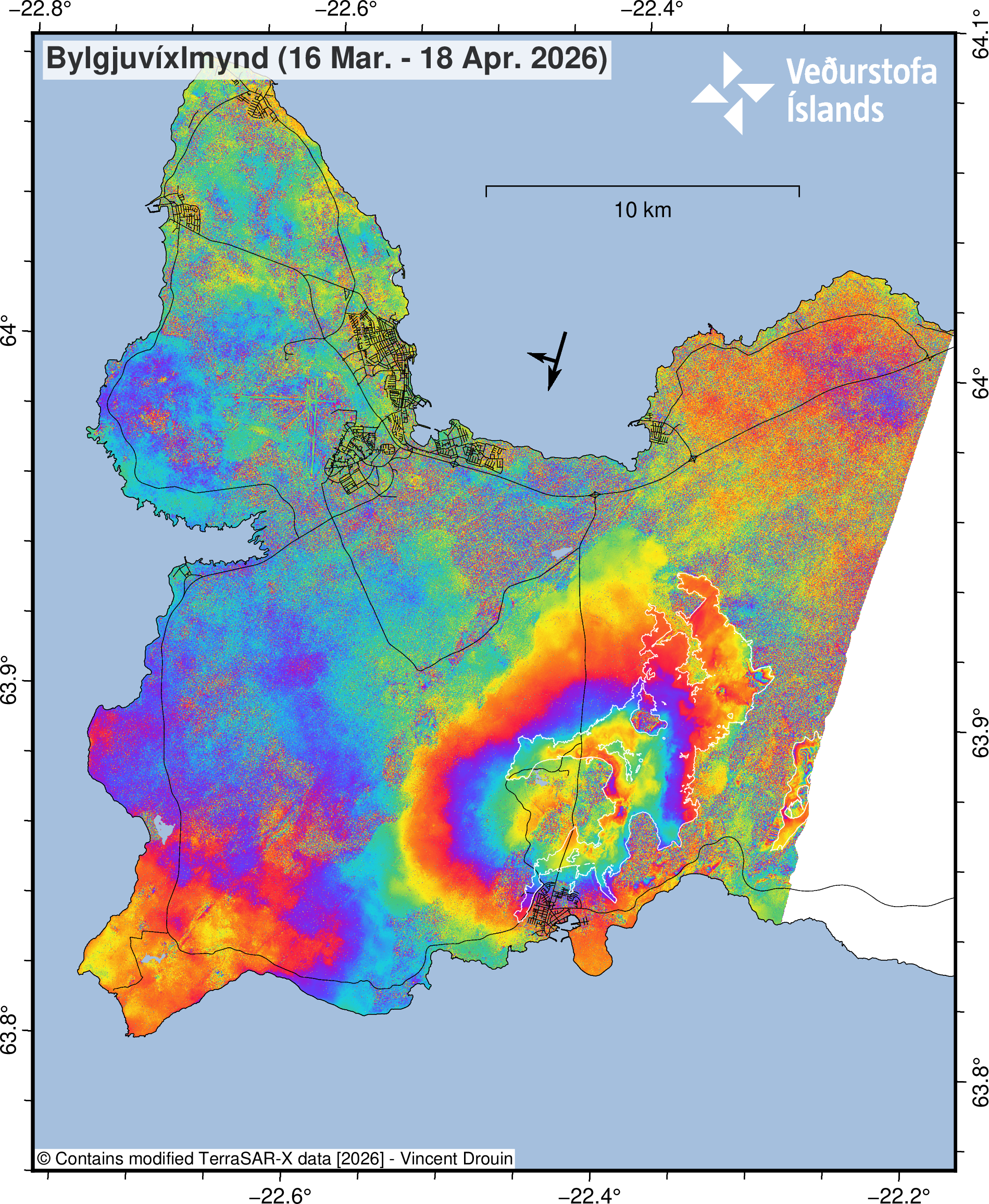
Satellite image covering the period March 16 – April 18, 2026, showing uplift at Svartsengi. The white contours identify the emplaced lava fields from previous eruptions in Sundhnúks crater row.
Seismic activity
Low seismic activity continues to be measured near the dike region, though it appears to have increased slightly over the past two weeks. Most earthquakes are below magnitude 1.
Source : IMO.
Photos : lProtection civile/Björn Oddsson , IMO.
Indonesia , Ibu :
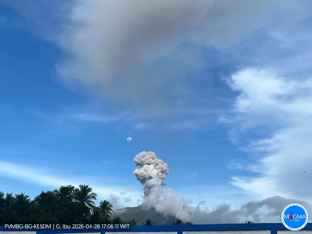
An eruption of Mount Ibu occurred on Tuesday, April 28, 2026, at 5:02 PM WIT, with an observed ash column height of approximately 700 m above the summit (approximately 2025 m above sea level). This ash column, white to gray in color, was of moderate to strong intensity and directed northwest. The eruption was recorded by a seismograph, with a maximum amplitude of 28 mm and a duration of 46 seconds.
Seismicity Observations
102 eruption earthquakes with amplitudes of 15 to 28 mm and durations of 35 to 145 seconds.
2 emission earthquakes with amplitudes of 8 to 10 mm and durations of 37 seconds.
17 harmonic tremors with amplitudes of 2 to 28 mm and durations of 43 to 143 seconds.
119 low-frequency earthquakes with amplitudes of 2 to 10 mm and durations of 17 to 29 seconds.
188 shallow volcanic earthquakes with amplitudes of 2 to 8 mm and durations of 7 to 21 seconds.
1 local tectonic earthquake with an amplitude of 2 mm and a duration of 7 to 33 seconds.
42 tectonic earthquakes, spaced apart, with amplitudes ranging from 2 to 28 mm and durations from 36 to 86 seconds.
Recommendations
1. Residents living around Mount Ibu and visitors/tourists are advised to refrain from all activities within a 2 km radius and for a distance of 3.5 km towards the crater opening in the northern part of the active Mount Ibu crater.
2. In the event of ashfall, people engaging in outdoor activities are advised to wear a mask covering their nose, mouth, and eyes, as well as protective eyewear.
Source et photo : PVMBG.
Colombia , Purace – Chaîne volcanique Los Coconucos :
Popayán, April 28, 2026, 3:00 PM
Regarding the monitoring of activity at the Puracé volcano and the Los Coconucos volcanic chain, the Geological Survey of Colombia (SGC), an agency under the Ministry of Mines and Energy, reports the following:
During the week of April 21-27, 2026, seismicity related to fluid movements within the volcanic edifice continued to be recorded. This activity is characterized by long-period (LP) earthquakes and tremor pulses (TR). These earthquakes, located below the crater of the Puracé volcano, at a depth of less than one kilometer, are linked to the circulation and release of volcanic gases into the atmosphere. These emissions dispersed according to the wind direction, reaching a maximum altitude of 795 meters above the summit of the volcano. In addition, a continuous tremor persists under the crater of the Piocollo volcano at a depth of less than 2 km, linked to the fluid dynamics within the volcanic system.
Low levels of sulfur dioxide (SO₂) emissions have been recorded, and gases continue to escape from fissures in the craters of the Curiquinga and Piocollo volcanoes. Furthermore, the slow deformation process continues between the Puracé, Piocollo, and Curiquinga volcanoes, which was detected after the eruptive episode of Curiquinga on January 20, 2025.
In conclusion, the variations observed at the Puracé volcano and the Los Coconucos volcanic chain indicate that the system continues to evolve and that further ash emissions and fallout are possible, depending on the prevailing wind direction. The public is advised not to travel to the higher elevations of the volcanic chain and to remain attentive to official reports from the Geological Survey of Colombia (SGC).
The alert level for volcanic activity remains yellow: active volcano with changes in the baseline behavior of monitored parameters and other manifestations.
Source : SGC.
Photo : Cauca Noticias Radio y TV
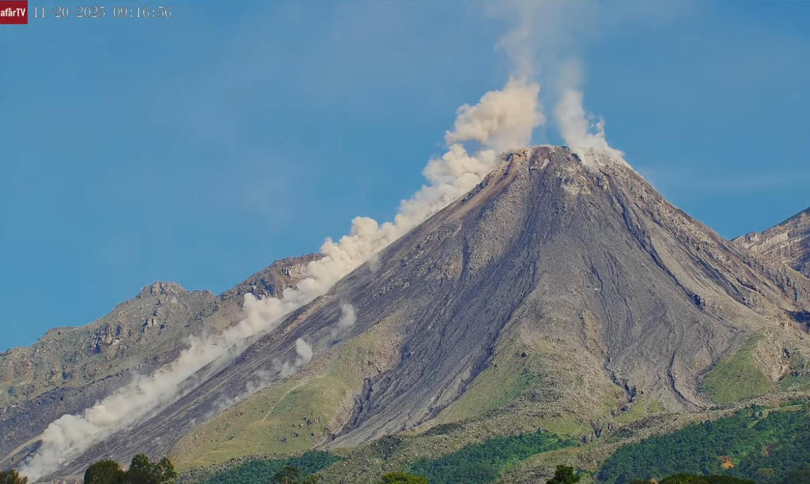
Guatemala , Santiaguito :
Atmospheric conditions: Cloudy
Wind: Northeast
Precipitation: 0.0 mm
Volcanic activity:
Constant degassing is observed above the Caliente dome, reaching a height of 500 meters and dispersing to the west and southwest. Low- to medium-intensity explosions have been recorded, as well as pyroclastic flows generating a column of gas and ash up to 900 meters above the dome, also dispersing to the west and southwest. During the night and early morning, incandescence is visible on the dome and its western and southwestern flanks, resulting from recurring avalanches cascading down these flanks.
Pyroclastic flows have been recorded, causing ashfall to the west and southwest. It is therefore necessary to follow the recommendations of Special Bulletin BESAN-002-2026.
Given the rainfall around the volcano, lahars of low to moderate intensity may occur along the streams on the southern flank (Nimá, Tambor, Cabello de Ángel, among others). It is therefore necessary to follow the recommendations of Special Bulletin BESAN-012-2026.
Source : Insivumeh .
Photo : Afar TV.