April 28 , 2026.
Hawaii , Kilauea :
HAWAIIAN VOLCANO OBSERVATORY DAILY UPDATE , U.S. Geological Survey
Monday, April 27, 2026, 9:09 AM HST (Monday, April 27, 2026, 19:09 UTC)
19°25’16 » N 155°17’13 » W,
Summit Elevation 4091 ft (1247 m)
Current Volcano Alert Level: ADVISORY
Current Aviation Color Code: YELLOW
Overview:
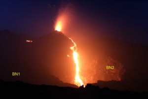
The eruption at the summit of Kīlauea is currently paused. Consistent glow and occasional flames continued from the south vent over the past day. The north vent produced only sporadic glow. The forecast window for episode 46, based on tilt data, suggests that lava fountaining will occur again sometime between Saturday, May 2 and Wednesday, May 6.
No significant activity has been noted along Kīlauea’s East Rift Zone or Southwest Rift Zone.
Summit Observations:
Consistent glow and occasional flames were visible from the south vent overnight, with sporadic glow from the north vent. Incandescence on the crater floor flow field has diminished completely and was mostly dark overnight.
Seismic tremor continues with 1–10 minute bursts that are typical for days after the end of fountaining, however magnitudes are decreasing somewhat. Earthquake activity at the summit has been low; nonetheless 24 small earthquakes were recorded over the past day, mostly under the pre-2018 location of Halemaʻumaʻu crater and scattered under the southeast caldera.
The Uēkahuna tiltmeter (UWD) recorded about 16.0 microradians of deflationary tilt during episode 45. Over the past day, the rate of inflationary tilt decreased slightly but tiltmeters continued to show net inflationary tilt. Since the end of episode 45, UWD has recorded 7.3 microradians of inflationary tilt.
With the eruption now paused, the SO2 emission rate is likely varying within a typical range of 1,000 to 5,000 tonnes per day.
Rift Zone Observations:
Rates of seismicity and ground deformation remain low in the East Rift Zone and Southwest Rift Zone. SO2 emissions from the East Rift Zone remain below the detection limit.
Source : AVO.
Photo : USGS / M. Patrick.
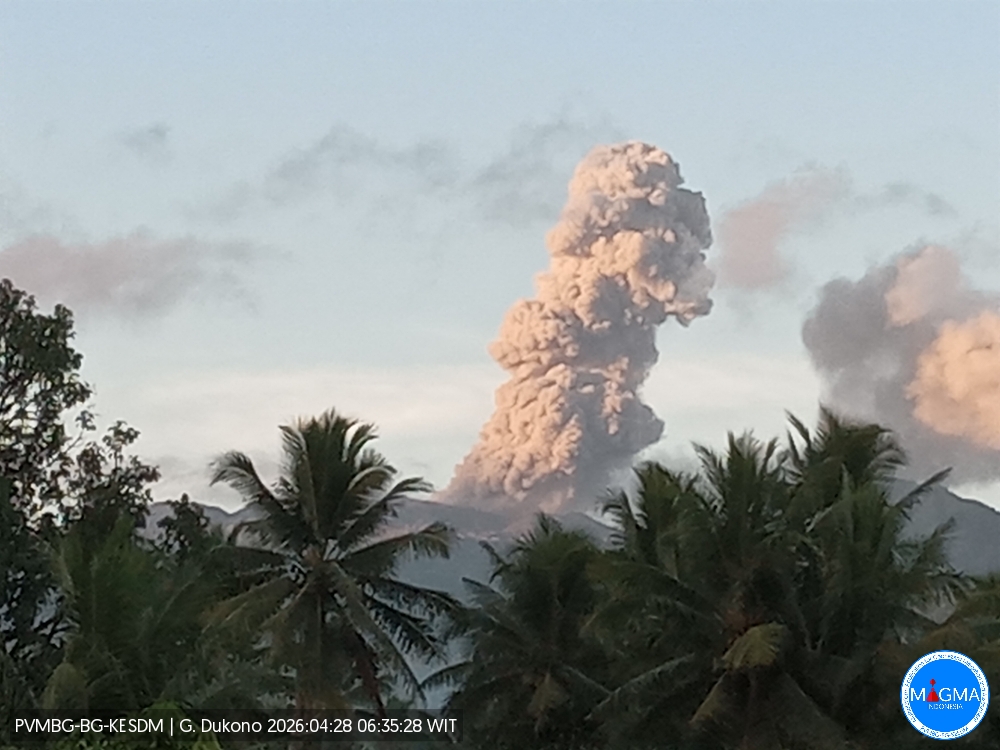
Indonesia , Dukono :
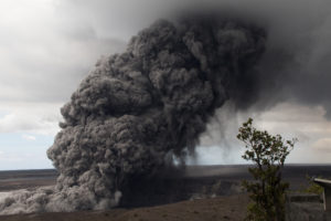
An eruption of Mount Dukono occurred on Tuesday, April 28, 2026, at 06:33 WIT, with an observed ash column height of approximately 900 m above the summit (approximately 1987 m above sea level). This ash column, white to gray in color, was thick and extended to the northwest. At the time of writing, the eruption was still ongoing.
Seismic Observations
74 eruption earthquakes with amplitudes between 8 and 34 mm and durations from 23.69 to 66.12 seconds.
3 distant tectonic earthquakes with amplitudes between 15 and 22 mm and durations from 58.61 to 63.52 seconds.
1 continuous seismic tremor with amplitudes between 1 and 6 mm, primarily 4 mm.
Recommendations
(1) Residents living near Mount Dukono and visitors/tourists are advised to refrain from any activity, climbing, or approaching the Malupang Warirang crater within a 4 km radius.
(2) Considering that eruptions with volcanic ash occur periodically and that the distribution of ash follows the direction and speed of the wind, so that the area where the ash lands is not constant, people living around Mount Dukono are advised to always carry masks/face coverings and mouth coverings to use when needed to avoid the threat that volcanic ash poses to the respiratory system.
Source et photo : PVMBG.
Costa Rica , Rincon de la Vieja :
Rincón de la Vieja erupted early Monday morning, producing the most intense eruption of 2026.
The volcano recorded a moderate explosion, but one of record energy for the year, according to OVSICORI, prompting alerts and attention from authorities and experts.
The eruption of the Rincón de la Vieja volcano shook the early hours of Monday morning, a fact that did not go unnoticed: although classified as moderate, it is the most energetic eruption recorded so far in 2026.
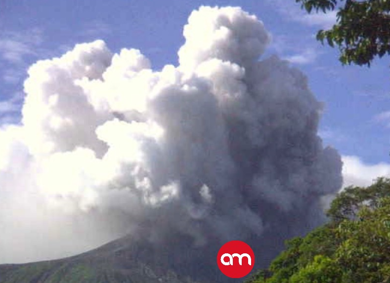
The event occurred at 3:03 a.m. and was detected by seismic and acoustic instruments at the Costa Rican Volcanological and Seismological Observatory (OVSICORI-UNA). Despite the eruption’s magnitude, specialists indicated that it was impossible to determine the height of the eruptive plume.
Authorities also specified that, despite the intensity of the phenomenon, no lahar formed. These volcanic mudflows generally represent one of the greatest risks during this type of event.
OVSICORI (National Observatory of Volcanology and Seismology) explained that volcanic activity remains within monitoring parameters, even though the volcano remains on alert. The institute also noted a change in wind direction toward the southwest, which could influence ash dispersal in the event of further eruptions.
Source : Ovsicori , AM Prensa .
Photo : AM Prensa.
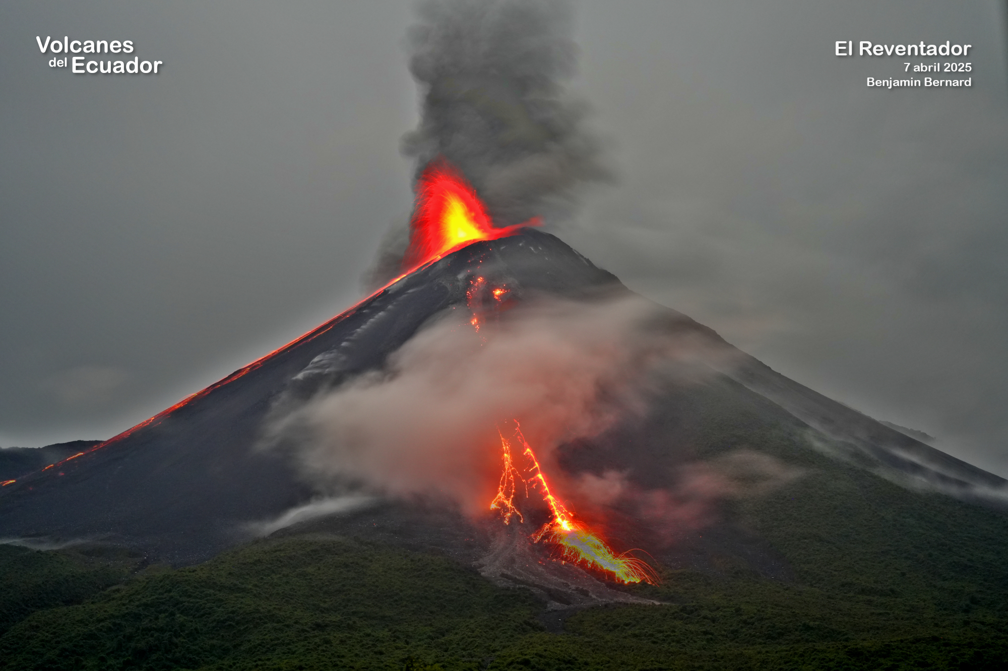
Ecuador , El Reventador :
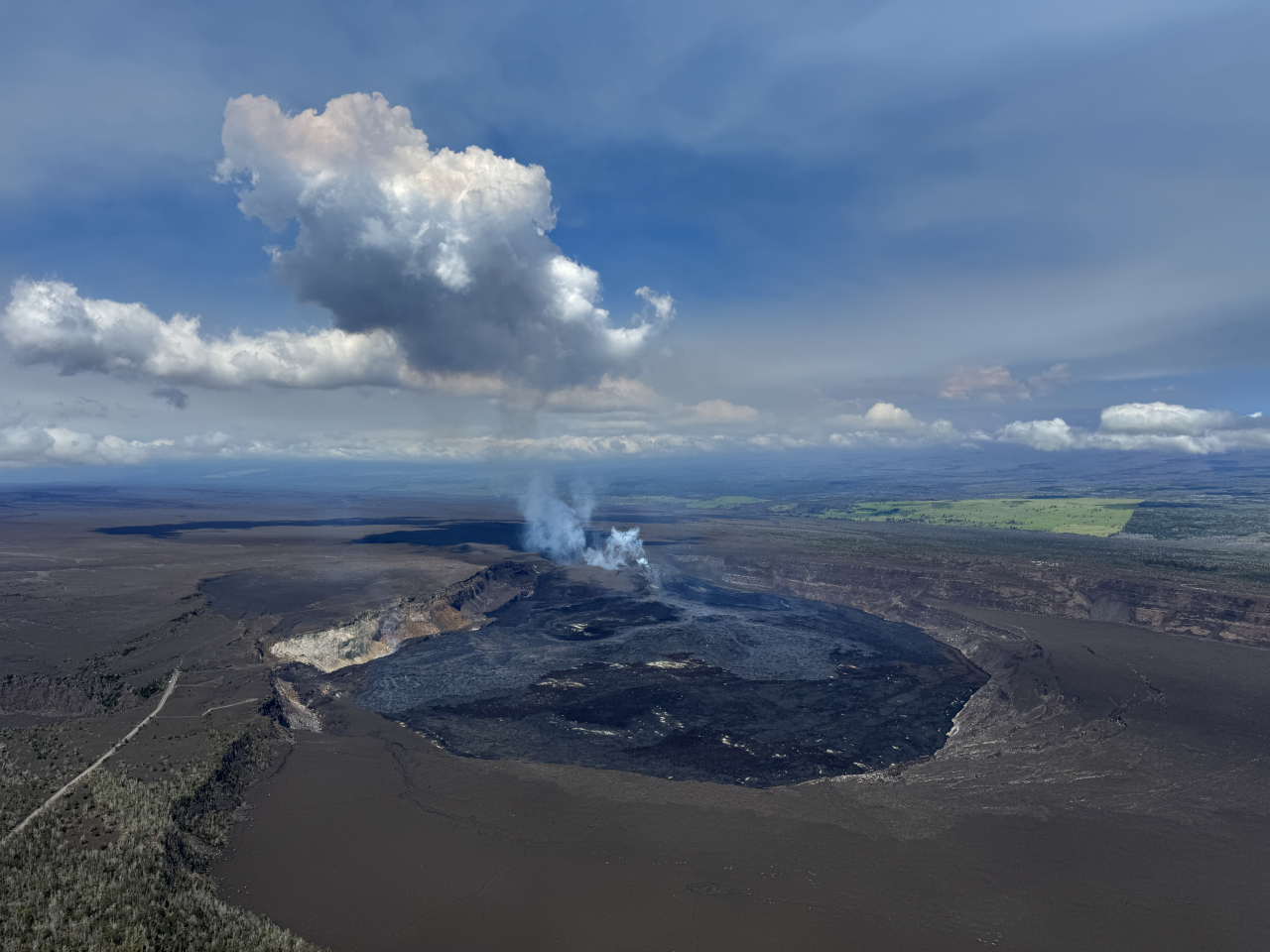
REVENTADOR VOLCANO DAILY STATE REPORT, Monday, April 27, 2026.
Information Geophysical Institute – EPN.
Surface Activity Level: High, Surface Trend: No Change
Internal Activity Level: Moderate, Internal Trend: No Change
From April 26, 2026, 11:00 AM to April 27, 2026, 11:00 AM:
Seismicity:
Explosive (EXP) 70
Long Period (LP) 17
Emission Tremor (TREMI) 14
Harmonic Tremor (TRARM) 9
Rainfall/Lahars:
Rainfall has been recorded in the area, causing a small lahar in the Marker River ravine. Heavy rain can remobilize accumulated material and generate debris-laden mudflows (lahars), which can rush down the volcano’s flanks and flow into nearby rivers.
Emissions/Ash:
Since yesterday afternoon, several gas and ash emissions have been observed by surveillance cameras. These emissions reached an altitude of less than 2,000 meters above the crater and drifted east, northeast, west, and northwest. They were also observed by satellite. The VAAC agency in Washington issued four reports concerning ash emissions at altitudes between 700 and 1,900 meters above sea level, drifting east, west, and northwest.
Observation:
The volcano remained clear for most of the time. During the night and early morning, incandescence was observed at the crater using the camera system, along with the descent of material to 1000 meters below the crater level on the eastern and southeastern flanks.
Alert Level – SGR: Orange
Source : IGEPN.
Photo : 7 avril 2025 , Benjamin Bernard.
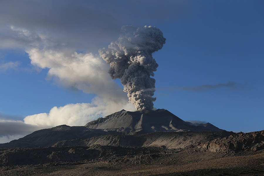
Peru , Sabancaya :
Local date and time: April 27, 2026 – 12:50 PM
Bulletin analysis period: April 20-26, 2026
Volcanic alert level
Orange alert level: The volcano’s eruptive activity has increased significantly. Increased seismic activity, frequent explosions, and emissions of ash and ballistic fragments have been observed.
Conclusions:
The IGP (Geophysical Institute of Peru) reports that the eruptive process of the Sabancaya volcano continues. During this period, no volcanic explosions were detected; however, emissions of ash, water vapor, and gases were recorded, reaching a maximum altitude of 1,800 meters above the volcano’s summit. Seismic activity associated with the movement of magmatic fluids and internal fracturing was also observed. Consequently, the volcanic alert level remains orange.
Recommendations:
Adopt prevention and preparedness measures in accordance with the current orange volcanic alert level.
Do not approach within 12 km of the crater. In case of ashfall, cover your nose and mouth with damp cloths or a mask. Keep doors and windows closed.
Outlook:
The occurrence of future volcanic explosions generating eruptive columns more than 2 km high is considered likely, with a risk of impact on districts in the Colca Valley and surrounding areas due to the dispersal of volcanic ash. Therefore, the volcanic alert level remains orange.
Source : Cenvul
Photo : Cenvul ( archive)