February 10 , 2026.
Philippines , Mayon :
MAYON VOLCANO ERUPTION UPDATE , 10 February 2026 , 02:15 AM
Summary of Surface Observations:
Since Mayon Volcano entered a period of magmatic eruption on 6 January 2026, its activity has been characterized by effusion or non-explosive eruption of lava from the summit crater, generating lava flows and collapse-fed rockfall and pyroclastic density currents (PDCs) or uson, hazardous mixtures of hot volcanic gas, ash and fragmented rock. These volcanic hazards have continually affected three (3) major drainage systems on the southern to eastern slopes – the Mi-isi, Bonga and Basud Gullies – including minor drainages in between, areas well within the 6-kilometer radius Permanent Danger Zone (PDZ). As of 8 February 2026, lava flows have advanced to radial distances of 1.3 km, 1.6 km and 3.8 km on the Mi-isi, Bonga and Basud Gullies, respectively, while rockfall and PDC runouts remained within the 3-kilometer radial distance from the summit crater. The total volume of magma erupted based on these deposits was estimated to be 22 million m3.
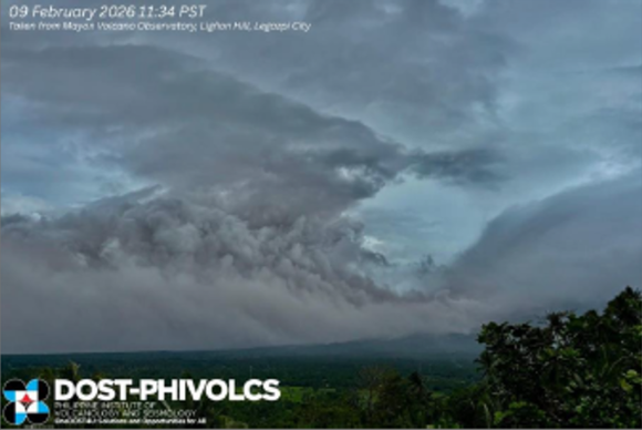
After a phase of relative low-level activity, rockfall increased to a peak count of 469 events on 8 February 2026, followed on 9 February 2026 by the largest PDC events so far generated by lava collapse. Three (3) major PDC events occurred between 2:30 AM and 2:44 AM but these were obscured for the greater part by cloud cover. Ashfall around this time was reported by residents of Tumpa, Camalig, Albay to the PHIVOLCS Quick Response Team (QRT) on routine reconnaissance on the western slopes later in the morning. From 10:35 AM to 11:37 AM (Figure 1), a series of at least 12 successive major PDC events occurred with the largest event at 10:59 AM lasting seven (7) minutes based on the seismic record. This series was poorly visible as well but produced prominent >2 kilometer-tall brownish to grayish ash clouds that were blown by ~40 kph winds extensively to the west of the volcano. Heavy and occasionally wet to trace ashfall was experienced by the localities of Camalig and Guinobatan, Albay Province
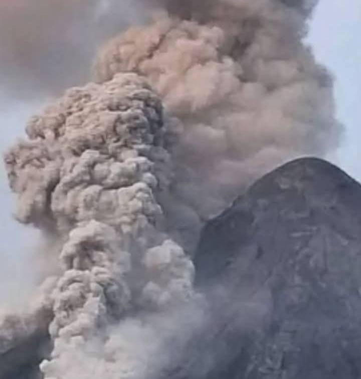
The 10:59 AM PDC and subsequent major PDC events were observed to have travelled down the 4-kilometer radial distance in the Mi-isi Gully, the farthest PDC runouts so far recorded for the 2026 eruption. Partial views show that the PDC sources were collapse events originating in the proximity of the crater and that likely disintegrated deposits of oxidized and degassed lava that contributed brownish ash in the PDC ash clouds. These observations, including the prior increase in rockfall activity, indicate that major PDC activity on 9 February 2026 was triggered by a substantial volume of lava fed to the Mi-isi lava flows, causing shedding of relatively larger volumes of pre-erupted material and potentially significant advancement of the Mi-isi lava flow front. Together with smaller-volume PDC and rockfall activity preceding and following these major PDC phases, 52 and 396 events, respectively, were recorded on 9 February 2026 (Figure 2).
Summary of Monitoring Parameters:
From 1 January to 9 February 2026, a total of 1,690 PDCs, 9,941 rockfall and 1,346 volcanic earthquakes have been recorded by the Mayon Volcano Observatory (MVO). Seismicity has been dominated by low-frequency volcanic earthquakes (LFVQs) that are associated with volcanic gas activity within the shallow levels of the volcanic edifice. Average SO2 emission for this period as well averaged 2,466 tonnes/day with a peak of 6,569 tonnes/day measured on 4 February 2026. Ground deformation data based on continuous GPS, electronic tilt and campaign EDM measurements since January 2025 indicate that the Mayon edifice has been unsteadily inflating or swelling, with its eastern to northeastern flank exhibiting extensional movement due to deep-seated magmatic intrusions (Figure 3).
Based on total seismic energy release (Figure 2, bottom), the 9 February 2026 major PDC activity represents only a brief intensification of unrest at Mayon, which has progressed in near-steady conditions since the onset of eruption.

Recommended Actions:
Alert Level 3 (magmatic unrest) is maintained over Mayon Volcano. DOST-PHIVOLCS would like to remind the public that effusive eruption is still ongoing and continues to feed new lava flows, PDCs and rockfall on the southern and eastern slopes. The public should refrain from entering the 6-kilometer radius Permanent Danger Zone (PDZ) due to the dangers of PDCs, lava flows, rockfalls and other volcanic hazards. Residents within the 8-kilometer radius, particularly on the southern and eastern slopes of Mayon, must also be prepared for evacuation in case monitoring parameters suddenly escalate and the volcano status is stepped up to Alert Level 4. Increased vigilance against lahars and sediment-laden streamflow along channels draining the edifice, particularly those headed on the Mi-isi, Bonga and Basud Gullies, is also advised in the event that intense rains occur over the summit area. Civil aviation authorities must also advise pilots to avoid flying close to the volcano’s summit as ash from any sudden eruption can be hazardous to aircraft.
DOST-PHIVOLCS maintains close monitoring of Mayon Volcano and any new development will be communicated to all concerned stakeholders.
Source : Phivolcs
Photos : Phivolcs , Jay L. Mostera , Father Paulo Barandon .
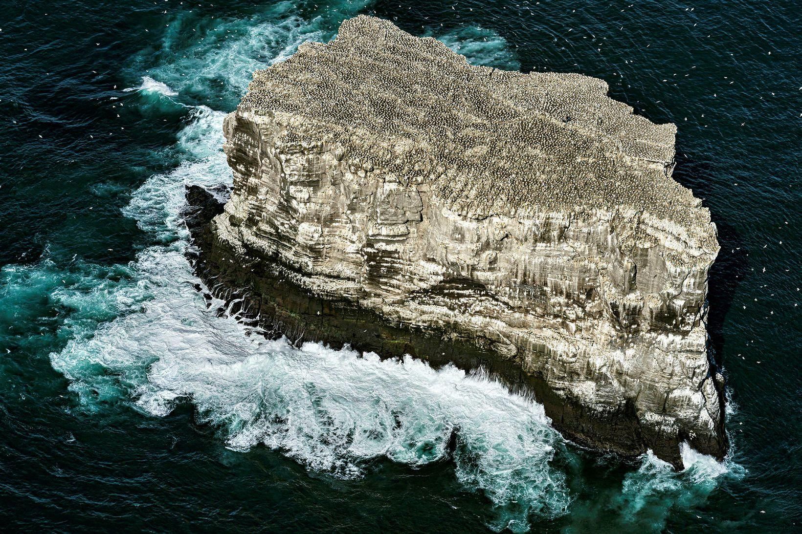
Iceland , Edley :
More than 300 earthquakes have been recorded in the seismic swarm that began near Eldey yesterday.
The swarm has continued in bursts. It has paused briefly and then resumed, according to Ingibjörg Andrea Bergþórsdóttir, a natural hazards specialist at the Icelandic Meteorological Office. The intensity has, however, decreased slightly since yesterday.
Many of the earthquakes overnight were in the magnitude 2.0 to 2.5 range, with the largest measuring 2.5. In total, around 330 earthquakes have been recorded.
The largest earthquake since the swarm began occurred yesterday and measured magnitude 3.4.
Not uncommon
Bergþórsdóttir says this seismic swarm is relatively strong, but it is not uncommon for such swarms to last one to two days. For example, a similar swarm occurred in the same area in November, lasting one to two days.
No volcanic tremor or magma accumulation has been detected on the Meteorological Office’s monitoring instruments in connection with the earthquakes, and it appears that the swarm is due to stress release or plate movements, as two tectonic plates are pulling apart.
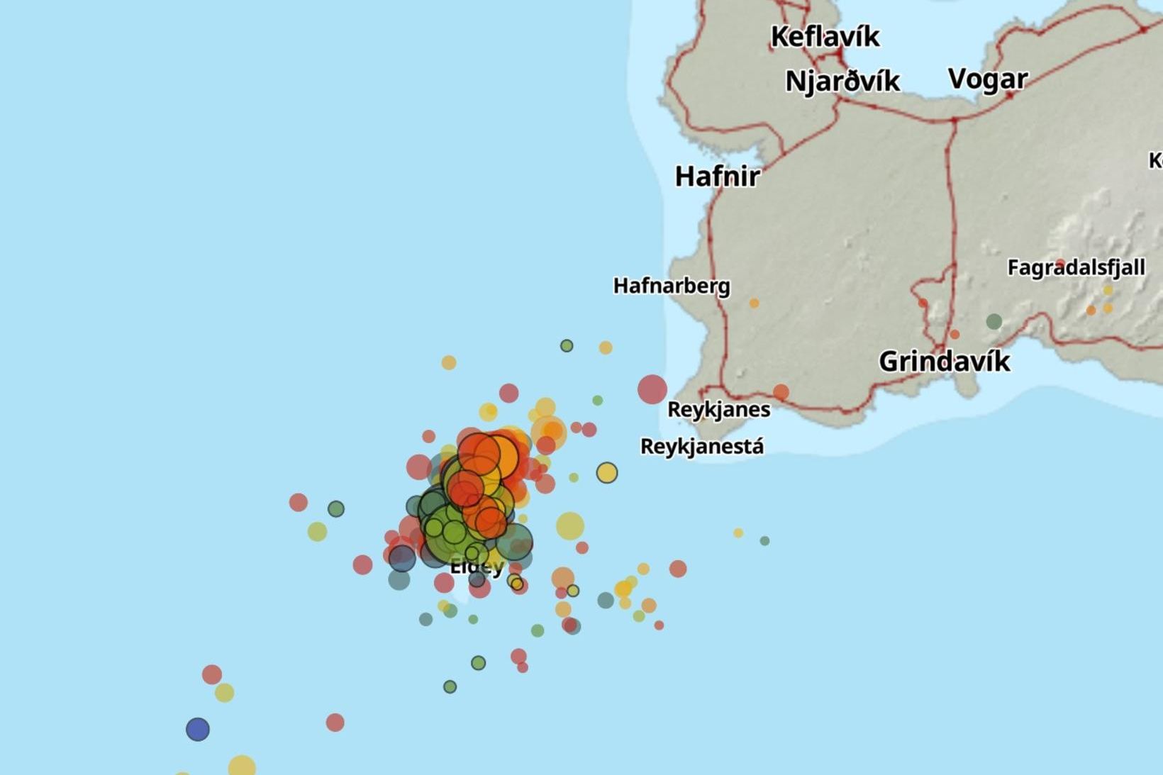
Asked whether the swarm could be connected to the volcanic area on the Reykjanes Peninsula, she says that as the magma chamber there fills with more magma, stress builds up in other parts of the peninsula, making it likely that the swarm is related.
The last earthquake swarm near Eldey occurred on 3 December last year.
Source : Iceland monitor.
Photos : Páll Stefánsson , IMO.
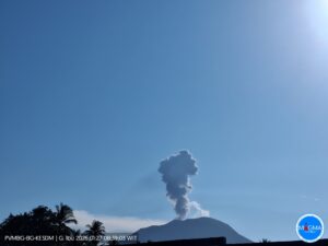
Hawaii , Kilauea :
HAWAIIAN VOLCANO OBSERVATORY DAILY UPDATE , U.S. Geological Survey
Monday, February 9, 2026, 8:52 AM HST (Monday, February 9, 2026, 18:52 UTC)
19°25’16 » N 155°17’13 » W,
Summit Elevation 4091 ft (1247 m)
Current Volcano Alert Level: WATCH
Current Aviation Color Code: ORANGE
Activity Summary:
The Halemaʻumaʻu eruption of Kīlauea is paused. Summit inflation continued over the past day, and glow at both the south and north vents was visible in the webcams overnight. The forecast for the onset of episode 42 lava fountaining is between February 11 and 14 based on current rates of summit inflation.
No significant activity has been noted along Kīlauea’s East Rift Zone or Southwest Rift Zone.
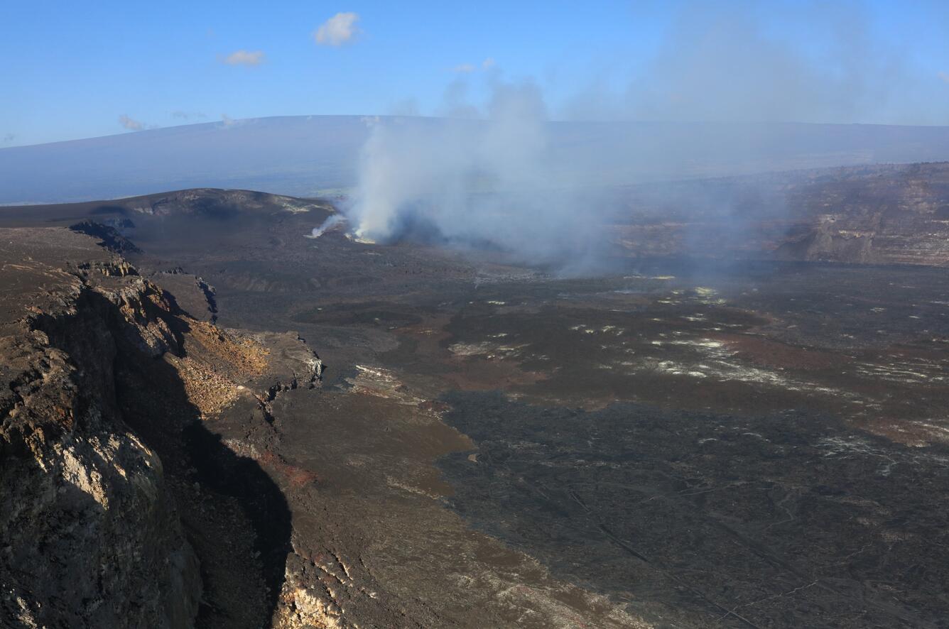
USGS Hawaiian Volcano Observatory staff participated in a monitoring overflight of Kīlauea summit caldera, Kaluapele, the morning of February 4, 2026, to investigate and collect samples of the episode 41 lava flows that were emplaced on January 24, 2026. These lava flows covered most of the crater floor during the lava fountaining episode.
Summit Observations:
Fluctuating moderate to strong glow was visible at the south and north vents overnight in the webcams.
Seismic tremor continued over the past 24 hours, and has been relatively steady over the past day. Earthquake activity at Kīlaueaʻs summit increased briefly overnight with a flurry of small events beneath the caldera. All were small magnitude (less than magnitude 2), and at a depth of approximately 6-8 km (4-5 miles).
The Uēkahuna tiltmeter (UWD) has recorded 27.3 microradians of inflationary tilt since the end of episode 41, with about 2 microradians over the past day. A slight amount of deflationary tilt is occurring this morning.
The sulfur dioxide (SO2) emission rate from the summit was last measured on February 2 at 5,172 tonnes per day, which is slightly higher than the typical range of 1,000 to 5,000 tonnes of SO2 per day observed during previous eruptive pauses. This is considerably lower than rates observed during lava fountaining episodes. This morning, webcams show that the plume from the summit vents is being carried to the southwest. The National Weather Service forecast indicates north northeast winds today at 16-22 mph.
Rift Zone Observations:
Rates of seismicity and ground deformation remain very low in the East Rift Zone and Southwest Rift Zone. SO2 emissions from the East Rift Zone remain below the detection limit.
Source : HVO.
Photo : USGS / D. Downs.
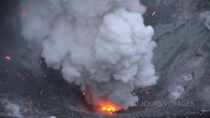
Guatemala , Fuego :
Atmospheric conditions: Clear skies
Wind: Northeast
Rainfall: 0 mm
Activity
Overnight and early this morning, weak to moderate explosions were recorded, accompanied by ash columns reaching altitudes between 4,200 and 4,500 meters, which dispersed southwest of the volcanic complex over a distance of approximately 25 kilometers. Ashfall was reported in San Pedro Yepocapa and in the towns of Panimache I and II, Morelia, and Santa Sofía.

Avalanches were also observed on the west, southwest, and south flanks, with some blocks reaching the vegetation. Some explosions generated rumbling sounds, shockwaves, and noises similar to those of a locomotive. Due to this activity, it is dangerous to remain on the plateau because of the risk of ballistic debris.
Source : Insivumeh.
Photo : Diego Rizzo .
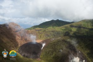
Costa Rica , Poas :
Latitude: 10.20°N
Longitude: 84.23°W
Altitude: 2,687 m
Current Activity Level: Alert
Overall, the amplitude of background seismic tremor remained stable throughout the week, with a slight decrease in recent days and a brief episode (less than one hour) of intense tremor on February 4. The number of long-period events has shown a downward trend since the end of December 2025. However, this week, a slight increase in this parameter and a decrease in the number of high-frequency events were observed. The geodetic network records an uplift of the crater relative to the tourist attraction, as well as a slight extension to the south of the volcano (VPCL and VPJA) relative to the same attraction.
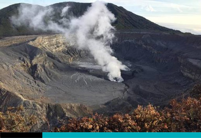
The MultiGAS station recorded SO₂/CO₂ values similar to those of last week, while the H₂S/SO₂ ratio increased slightly. The SO₂ concentration at the observation point reached a maximum of 6.1 ppm this week. DOAS stations detected a sulfur dioxide (SO₂) flux of 140 ± 136 t/d, lower than the previous week’s 240 ± 98 t/d. SO₂ was detected in the atmosphere by satellite only on January 30, with a low flux of 18.5 tonnes. The lake level rose 2.6 m during the passage of the cold front this week, ultimately reaching a rise of 2.4 m compared to last week.
Source et photo : Ovsicori .