February 4 , 2026.
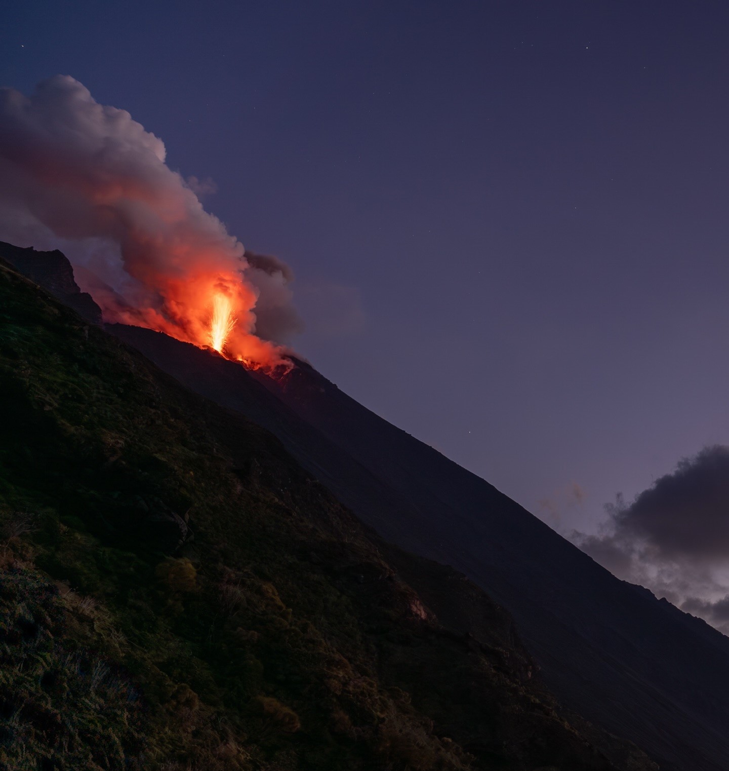
Italy , Stromboli :
WEEKLY BULLETIN, January 26, 2026 to February 1, 2026. (Publication date: February 3, 2026)
ACTIVITY SUMMARY
Based on monitoring data, the following points should be noted:
1) VOLCANOLOGICAL OBSERVATIONS: During this period, ordinary Strombolian-type eruptive activity was observed. The total hourly frequency fluctuated between average values (11 events/h) and high values (19 events/h). The intensity of the explosions was mostly low to medium in the North and Central-South crater areas.
2) SEISMOLOGY: The monitored seismic parameters showed no significant variation.
3) GROUND DEFORMATION: The ground deformation monitoring networks did not show significant variations. The tilt measurement network is still affected by disturbances that compromise its reliability.
4) GEOCCHEMISTRY: Average SO₂ flux.
Very high CO₂ flux from the ground in the Pizzo area (STR02).
C/S ratio in the feather, average values.
Helium isotope ratio (R/Ra) dissolved in the thermal aquifer: no update. Last data: 12/12/2025 (high value: 4.44).
CO₂ flux from the ground in the San Bartolo area: average value.
CO₂ flux from the ground in the Scari area: almost stable (average to high value).
5) SATELLITE OBSERVATIONS: Satellite-observed thermal activity in the summit area was generally low.
VOLCANOLOGICAL OBSERVATIONS
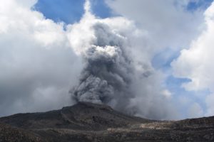
During the observation period, Stromboli’s eruptive activity was characterized by analyzing images recorded by the INGV-OE monitoring cameras located at an altitude of 190 m (SCT-SCV) and at Punta dei Corvi (SPCT). Explosive activity was primarily produced by five eruptive vents located in the northern crater area and by at least two vents located in the central-southern area.
Due to heavy cloud cover on January 31, visibility of the crater terrace was insufficient to ensure a detailed and continuous description of the eruptive activity.
Observations of explosive activity captured by monitoring cameras
Five active vents were observed in the northern (N) crater area, two in sector N1, and three in sector N2.
The explosive activity produced was of low intensity (less than 80 m high) and medium intensity (less than 150 m high).
The eruptive products were primarily coarse material (bombs and lapilli). The average frequency of explosions ranged from 11 to 18 events per hour.
In the Central-South (CS) crater area, two main vents were observed, which produced explosions of fine material mixed with coarse material, ranging from low to medium intensity. The average frequency of explosions ranged from -1 to 6 events per hour.
Source : INGV.
Photo : Stromboli stati d’animo / Sebastiano Cannavo
Italy / Sicily , Etna :
WEEKLY BULLETIN, January 26, 2026 to February 1, 2026. (Publication date: February 3, 2026)
ACTIVITY SUMMARY
Based on monitoring data, the following points should be noted:
1) VOLCANOLOGICAL OBSERVATIONS: Degassing at varying rates at summit craters.
2) SEISMOLOGY: Low seismic activity due to fracturing. Tremor amplitude low to medium.
3) INFRASOUND: Low infrasound activity.
4) GROUND DEFORMATION: Ground deformation monitoring networks did not show significant variations during the week.
5) GEOCHEMISTRY: SO₂ flux at a medium level.
The CO₂ flux from the ground (EtnaGas network) is low.
Partial pressure of dissolved CO₂ in groundwater (EtnaWater network): no update.
Helium isotope ratio at peripheral stations: average values, decreasing (latest data from December 22).
6) SATELLITE OBSERVATIONS: Over the past week, thermal activity observed by satellite in the summit area has generally been low.
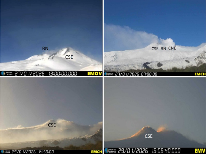
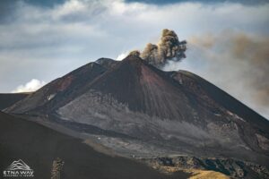
Variable-rate degassing activity from the summit craters, captured on January 27 by visible-light cameras: by EMOV La Montagnola and EMCH Monte Cagliato (top images) and on January 29 by EMCH Monte Cagliato and EMV Milo (bottom images). CSE = Southeast Crater, BN = Bocca Nuova, CNE = Northeast Crater.
VOLCANOLOGICAL OBSERVATIONS
The monitoring of Etna’s volcanic activity was carried out by analyzing images from the Etna Observatory’s (INGV-OE) camera network. However, the presence of clouds and strong winds at the summit of Etna for almost the entire study period severely limited observations of volcanic activity. Overall, during the study period, Etna’s activity was characterized by degassing of varying intensity and frequency at the summit craters.
On the rare occasions when the summit crater area was exposed before cloud cover, such as during certain hours on January 27 and 29, the craters were observed to be affected by intense degassing activity at varying rates.
Source : INGV.
Photo : INGV.
Indonesia , Semeru :
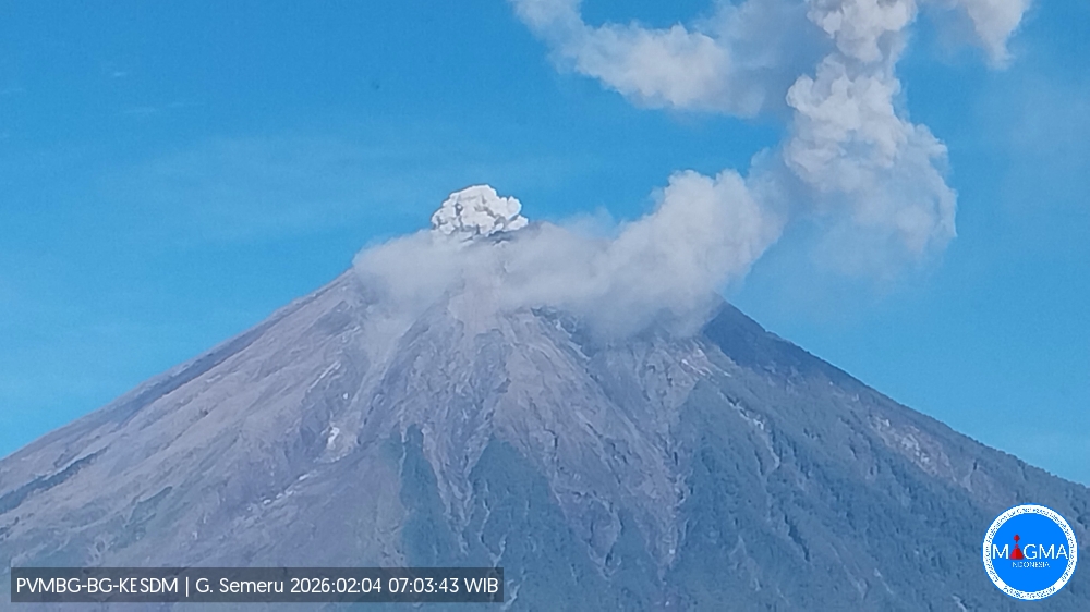
Mount Semeru erupted on Wednesday, February 4, 2026, at 7:05 a.m. West Indonesian Time. An ash column was observed approximately 600 meters above the summit (at an altitude of about 4,276 meters). This column, white to gray in color and of moderate intensity, was drifting northward. At the time of writing, the eruption was still ongoing.
VOLCANO OBSERVATORY NOTICE FOR AVIATION – VONA
Issued : February 4 , 2026
Volcano : Semeru (263300)
Current Aviation Colour Code : ORANGE
Previous Aviation Colour Code : orange
Source : Semeru Volcano Observatory
Notice Number : 2026SMR248
Volcano Location : S 08 deg 06 min 29 sec E 112 deg 55 min 12 sec
Area : East java, Indonesia
Summit Elevation : 11763 FT (3676 M)
Volcanic Activity Summary :
Eruption with volcanic ash cloud at 0005 UTC (0705 local).
Volcanic Cloud Height :
Best estimate of ash-cloud top is around 13683 FT (4276 M) above sea level or 1920 FT (600 M) above summit. May be higher than what can be observed clearly. Source of height data: ground observer.
Other Volcanic Cloud Information :
Ash cloud moving to north. Volcanic ash is observed to be white to gray. The intensity of volcanic ash is observed to be medium.
Remarks :
Eruption recorded on seismogram with maximum amplitude 21 mm and maximum duration 109 second.
Source et photo : Magma Indonésie.
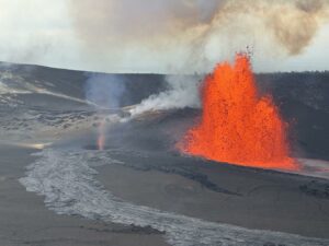
Colombia , Puracé – Los Coconucos volcanic chain :
Popayán, February 3, 2026, 4:00 PM
Regarding the monitoring of activity at the Puracé volcano and the Los Coconucos volcanic chain, the Colombian Geological Survey (SGC), an agency under the Ministry of Mines and Energy, reports the following:
During the week of January 27 to February 2, 2026, earthquakes associated with fluid circulation within the volcanic edifice continued to occur. These were long-period (LP) and tremor (TR) earthquakes. These earthquakes were located below the crater of the Puracé volcano, at depths of less than 1 km, and were related to circulation processes and the release of volcanic gases into the atmosphere. Compared to previous weeks, fracture seismicity remained stable, both in number and seismic energy released, with events occurring mainly between the Puracé, Piocollo, and Curiquinga volcanoes, at depths of 1 to 3 km. Sulfur dioxide (SO₂) emissions continue to be recorded, and gases continue to escape from fissures in the craters of the Curiquinga and Piocollo volcanoes, although no associated ash emissions have been identified to date. Satellite observations have recorded a very low-energy thermal anomaly in the Puracé volcano crater.
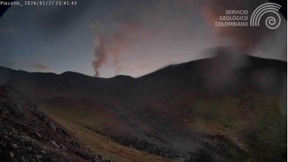
A recording from a camera inside the crater of the Curiquinga volcano shows degassing through a fissure on its northern wall. Image taken on January 27, 2026.
Furthermore, the slow deformation process continues between the Puracé, Piocollo, and Curiquinga volcanoes, detected after the eruptive episode of Curiquinga on January 20, 2025. On the evening of February 1, the Colombian Geological Survey (SGC) received reports of ashfall in the rural communities of Río Negro, Alto de la Laguna, and Cristales, in the municipality of Puracé, located west and northwest of the volcano. Ash emissions could continue, as predicted by the yellow alert, and their dispersal will depend on wind patterns. Furthermore, seismic data and webcam images recorded three secondary mudflows (lahars) along the Cocuy River basin, toward the northeast flank of the volcanic chain, on January 29 at 12:15 PM and on February 1 at 2:27 PM and 3:45 PM.
These lahars are associated with heavy rainfall and the remobilization of ash deposited in recent months in the upper reaches of the Puracé, Piocollo, and Curiquinga volcanoes. Events of this type could continue to be recorded during periods of heavy rainfall in the highlands, with recent ash accumulation.
In conclusion, the variations observed at the Puracé volcano – Los Coconucos volcanic chain indicate that the system continues to evolve and that ash emissions and fallout could continue, depending on the prevailing wind direction. The public is advised not to venture into the higher elevations of the volcanic chain and to remain attentive to official bulletins from the Geological Survey of Colombia (SGC).
The alert level for volcanic activity remains yellow: active volcano exhibiting changes in the baseline behavior of monitored parameters and other manifestations.
Source et photo : SGC.
Alaska , Shishaldin :
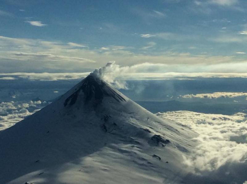
Shishaldin Volcano continues to experience unrest. Over the past day, there has been slightly elevated seismic activity, including numerous small earthquakes and volcanic tremor. A plume of mostly water vapor (steam) was observed in clear web camera views over the past day. Satellite imagery captured over the past day has shown no significant changes or noteworthy features in clear to partly cloudy conditions.
Local seismic and infrasound sensors, web cameras, and a geodetic network are used to monitor Shishaldin Volcano. In addition to the local monitoring network, AVO uses nearby geophysical networks, regional infrasound and lightning data, and satellite images to detect eruptions.
Source : AVO
Photo : Wetzel, Tarek.