January 23 , 2026.
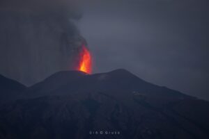
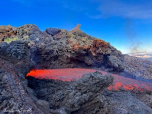
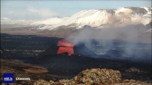
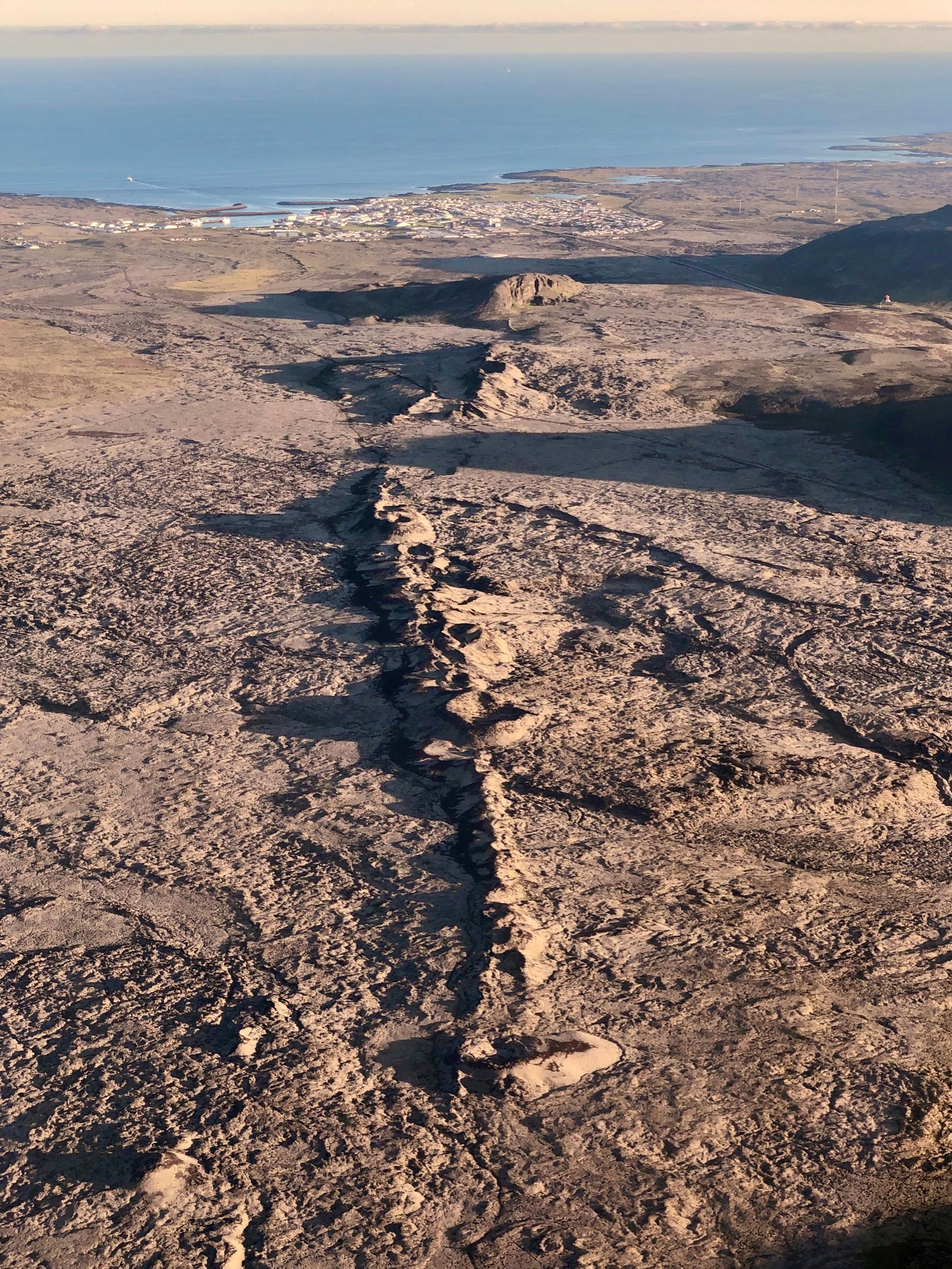
Iceland , Reykjanes Peninsula :
Continued increased likelihood of an eruption on the Sundhnúkur crater row . Updated 20 January
Magma accumulation continues beneath Svartsengi
Magma intrusion and volcanic eruption along the Sundhnúkur crater row are the most likely scenarios
Approximately 20 million cubic metres of magma have accumulated since the last eruption
Seismic activity remains low in the area
The hazard assessment remains unchanged until 3 February, unless activity changes
Magma accumulation
Magma accumulation beneath Svartsengi is slow but steady, similar to what has been observed in recent weeks. According to model calculations, nearly 20 million cubic metres of magma have now accumulated beneath Svartsengi since the last volcanic eruption in July.
As magma accumulation continues and pressure within the system increases, the most likely scenario in the coming weeks is a magma intrusion propagating from Svartsengi towards the Sundhnúkur crater row, which could end in a volcanic eruption. If an eruption occurs, it is most likely to be similar in character to the events that have occurred so far along the Sundhnúkur crater row.
Looking back to the onset of magma accumulation beneath Svartsengi in November 2023, total uplift amounts to just under 1 meter. The rate of uplift was highest at the beginning but has gradually decreased with each subsequent event.
Seismic activity
Seismic activity in recent weeks has been relatively stable, with earthquakes mainly located between Sýlingarfell and Stóra-Skógfell, south of Þorbjörn, and at Víkur. Most earthquakes are smaller than M1.5. Seismicity at Víkur is interpreted as triggered earthquakes caused by stress changes in the area. Seismic activity continues to decrease at Kleifarvatn.
Source : IMO.
Photo : Siggi Anton.
Philippines , Mayon :
The Philippine Institute of Volcanology and Seismology (PHIVOLCS) reported that the eruption at Mayon continued during 15-21 January, characterized by effusion and collapses at the summit dome, pyroclastic density currents (PDCs), rockfalls, ash plumes, avalanches of incandescent material, and lava flows. Moderate emissions rose as high as 800 m above the summit and drifted in various directions during 14-15 and 19-20 January; weather clouds obscured views on the other days. Seismic stations recorded 207 rockfall events and 27 PDCs on 14 January. Real-time Seismic Amplitude Measurement (RSAM) data increased during 15-16 January due to increasing numbers of rockfalls and PDCs, indicative of a higher effusion rate. Intense degassing was visually observed during the morning of 16 January with sulfur dioxide emissions averaging 4,970 tonnes per day (t/d), the highest average recorded during the past 15 years. Daily rockfall and PDC counts remained high during the rest of the week with 235-340 daily rockfall events and 45-72 daily PDCs recorded during 15-20 January.
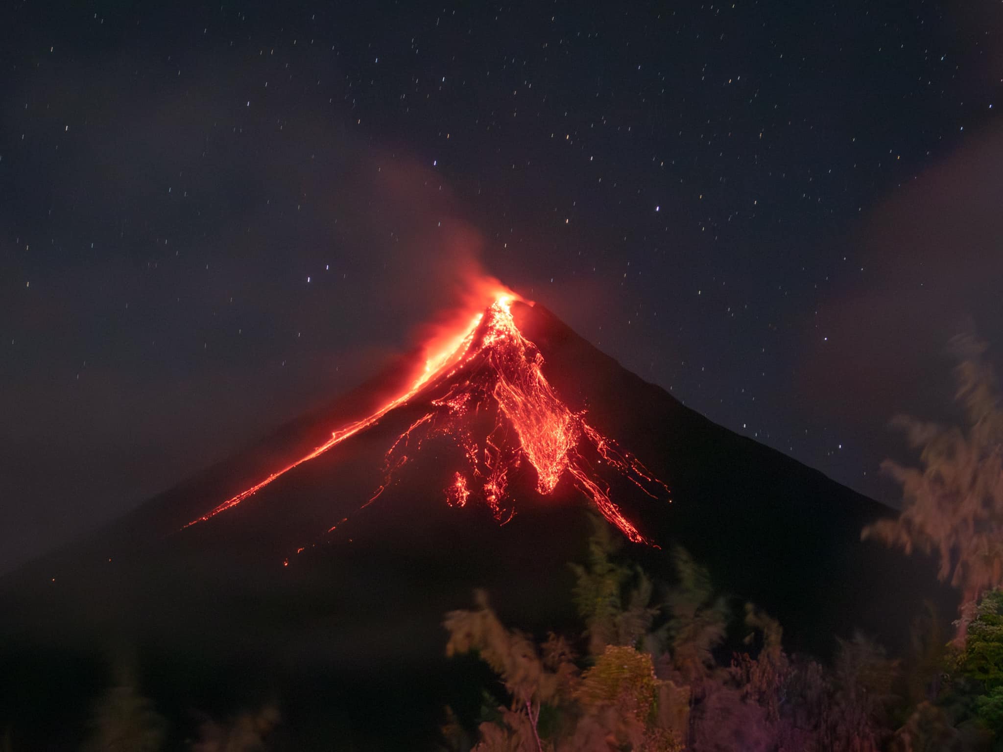
Sulfur dioxide emissions decreased after the peak on 16 January but continued to remain high. No volcanic earthquakes were recorded during the first part of the week but on 18, 19, and 20 January the seismic network detected 19, 13, and 83 volcanic earthquakes, respectively. By 06h00 on 21 January a total of 4,092 people (1,114 families) had moved to 14 evacuation shelters, and an additional 51 people (17 families) were staying with friends or relatives, according to the Disaster Response Operations Monitoring and Information Center (DROMIC). Episodic Strombolian activity at the summit was visible during 20-21 January. The Alert Level remained at 3 (on a 0-5 scale) and residents were reminded to stay away from the 6-km-radius Permanent Danger Zone (PDZ). PHIVOLCS recommended that civil aviation authorities advise pilots to avoid flying close to the summit.
Sources: Philippine Institute of Volcanology and Seismology (PHIVOLCS), Disaster Response Operations Monitoring and Information Center (DROMIC), GVP.
Photo : Rick Estillomo .
Indonesia , Merapi :
The Pusat Vulkanologi dan Mitigasi Bencana Geologi (PVMBG) reported that the eruption at Merapi (on Java) continued during 15-21 January. The SW lava dome produced pyroclastic flows or avalanches of material that descended the flanks on most days. On 17 January a pyroclastic flow traveled 1 km down the SW flank and a pyroclastic flow was detected by the seismic network on 18 January. Four avalanches of material descended the Bebeng drainage on the SW flank as far as 1.5 km and two descended the same drainage on 21 January, traveling as far as 1.8 km. During 17-18 and 20 January there were 5-11 daily avalanches of material that traveled 1.7-1.9 km down the Sat/Putih drainage on the W flank. The Alert Level remained at 3 (on a scale of 1-4), and the public was warned to stay 3-7 km away from the summit, based on location.

Merapi, one of Indonesia’s most active volcanoes, lies in one of the world’s most densely populated areas and dominates the landscape immediately north of the major city of Yogyakarta. It is the youngest and southernmost of a volcanic chain extending NNW to Ungaran volcano. Growth of Old Merapi during the Pleistocene ended with major edifice collapse perhaps about 2,000 years ago, leaving a large arcuate scarp cutting the eroded older Batulawang volcano. Subsequent growth of the steep-sided Young Merapi edifice, its upper part unvegetated due to frequent activity, began SW of the earlier collapse scarp. Pyroclastic flows and lahars accompanying growth and collapse of the steep-sided active summit lava dome have devastated cultivated lands on the western-to-southern flanks and caused many fatalities.
Sources: Pusat Vulkanologi dan Mitigasi Bencana Geologi (PVMBG, also known as CVGHM), GVP.
Photo : imamismadin
Colombia , Puracé – Los Coconucos volcanic chain :
Popayán, January 22, 2026, 10:00 AM
Regarding the monitoring of activity in the Los Coconucos volcanic chain, the Colombian Geological Survey (SGC), an agency under the Ministry of Mines and Energy, reports the following:
The alert level for the Puracé volcano – Los Coconucos volcanic chain – has been lowered from orange to yellow: Active volcano with changes in monitored parameters and other manifestations.
Over the past two weeks, the activity of the Puracé volcano has shown a gradual decrease in several monitored parameters, leading to the change in the alert level from yellow to orange on November 29, 2025. This development indicates a trend toward stabilization of the volcanic system, allowing a return to the yellow alert level. The following technical parameters were taken into account:
● Since January 6, a significant decrease in the frequency and energy of ash emissions has been observed.
● The seismic energy associated with fluid movements within the volcano, which had increased from December 27, 2025, has decreased in recent days.
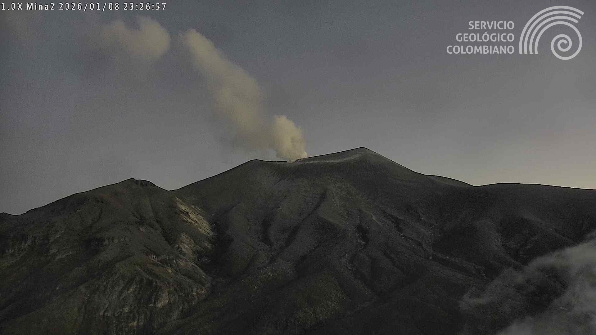
● The thermal anomaly recorded last December in the volcano’s crater has diminished, and no anomalies have been detected since January 12. This temperature variation was linked to heat transport by gases escaping from the volcano’s interior into the atmosphere.
● Sulfur dioxide (SO₂) emission levels have not shown significant increases or abrupt variations that would indicate an increase in the supply of this magmatic gas.
● Deformation of the volcanic surface remains at rates similar to those recorded before the orange alert level was raised, with no further changes observed in the deformation process.
It is important to note that, although the monitored parameters of the Puracé volcano – part of the Los Coconucos volcanic chain – are trending toward stability, the situation could deteriorate rapidly at any time, leading to a return to the orange alert level or even a move to the red alert level. It is therefore essential that the public closely monitor the evolution of volcanic activity and avoid the crater area, as it could be affected by a sudden emission of gas or ash.
The alert level for volcanic activity has been raised to Yellow: Volcano exhibiting significant variations in monitored parameters.
Source et photo : SGC.
Japan , Sakurajima :
The Japan Meteorological Agency (JMA) reported ongoing eruptive activity at Minamidake Crater (Aira Caldera’s Sakurajima volcano) during 12-19 January. Eruptive events during 16 and 18-19 January produced ash plumes that rose 1-1.4 km above the crater rim and mainly drifted E. A period of continuous ash emissions during 15h47-17h05 on 16 January produced ash plumes that rose as high as 1.2 km above the crater rim and drifted NE. Crater incandescence was visible in webcam images during 16-19 January. The Alert Level remained at 3 (on a 5-level scale), and the public was warned to be cautious within 2 km of both the Minimadake and Showa craters.

The Aira caldera in the northern half of Kagoshima Bay contains the post-caldera Sakurajima volcano, one of Japan’s most active. Eruption of the voluminous Ito pyroclastic flow accompanied formation of the 17 x 23 km caldera about 22,000 years ago. The smaller Wakamiko caldera was formed during the early Holocene in the NE corner of the caldera, along with several post-caldera cones. The construction of Sakurajima began about 13,000 years ago on the southern rim and built an island that was joined to the Osumi Peninsula during the major explosive and effusive eruption of 1914. Activity at the Kitadake summit cone ended about 4,850 years ago, after which eruptions took place at Minamidake. Frequent eruptions since the 8th century have deposited ash on the city of Kagoshima, located across Kagoshima Bay only 8 km from the summit. The largest recorded eruption took place during 1471-76.
Sources: Japan Meteorological Agency (JMA) , GVP.