December 19 , 2025.
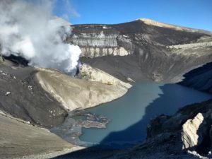
Chile / Argentina , Planchón-Peteroa :
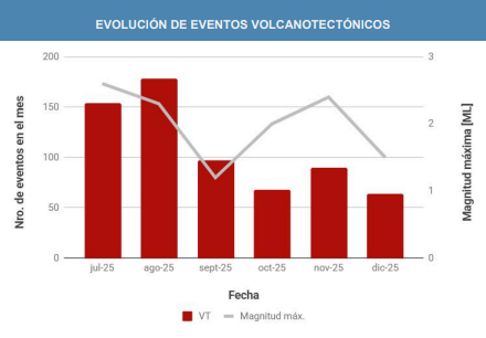
For the evaluated period, volcano-tectonic (VT) seismic activity, associated with rock fracturing within the volcano, showed a very slight increase in the number of recorded events, while a decrease in the energy levels associated with these events was observed compared to the previous period.
The highest-energy VT event recorded had a local magnitude (ML) of 1.5 and was located 5.7 km north-northeast (NNE) of the volcanic edifice, at a depth of 6.3 km,
relative to the active crater. Seismic activity associated with fluid movement within the volcano, represented by long-period (LP) and tremor (TR) events, showed a slight increase in the number of recorded events compared to the previous period.
However, a slight decrease in the energy released was observed. The maximum energy released for LP events, recorded by reduced displacement (DR), was 11 cm². For TR events, the maximum reduced displacement (DR) value was 16 cm². Furthermore, the energy of the continuous tremor signal, recorded from the RSAM value and associated with sustained fluid dynamics within the volcano, fluctuated throughout the period, primarily due to variations in surface activity.
These values remain above the reference level for this volcano. During the two weeks, low-altitude degassing plumes were repeatedly recorded at the summit. On December 4, the maximum height reached during this period was detected, at 1,000 m above the crater rim. It should also be noted that on December 13 and 14, the presence of fine particles (volcanic ash) was detected through the interpretation of satellite images. Furthermore, nighttime incandescence of varying intensity was recorded on December 6, 10, and 12. During the study period, the analysis of satellite data revealed no anomalies in sulfur dioxide (SO₂) emissions into the atmosphere near the volcanic edifice. During this same period, satellite image processing detected three low-magnitude thermal anomalies, each with a maximum radiative power (MRP) of 1.52 MW, on December 1st and 3rd. Geodetic monitoring conducted during this period recorded no significant variations related to volcanic activity. Morphological analysis, based on PlanetScope and Sentinel-2 L2A satellite images, revealed new pyroclastic fallout deposits extending up to 3.5 km southeast (SW) of the active crater.
CONCLUSIONS
During the study period, the activity of the Planchón-Peteroa volcanic complex was at levels similar to those of the previous two weeks. In particular, the continuous recording of seismic activity, primarily associated with fluid dynamics within the volcano (LP and Tremor seismic events), showed values comparable to those recorded during the last two weeks of November.
At the surface, the recurring emission of low-altitude degassing columns of SO₂ (sulfur dioxide) and water vapor from Crater No. 3 was recorded.
In addition, isolated episodes of fine particulate matter emissions (volcanic ash) were detected by satellite imagery.
Furthermore, localized thermal anomalies and nocturnal incandescence phenomena were observed. All of this data indicates that, despite lower energy in surface processes, signs of instability persist within the system during the interaction of fluids and active seismic sources.
Source : Segemar.
Photos : Segemar.
Hawaii , Kilauea :
HAWAIIAN VOLCANO OBSERVATORY DAILY UPDATE , U.S. Geological Survey
Thursday, December 18, 2025, 9:16 AM HST (Thursday, December 18, 2025, 19:16 UTC)
19°25’16 » N 155°17’13 » W,
Summit Elevation 4091 ft (1247 m)
Current Volcano Alert Level: WATCH
Current Aviation Color Code: ORANGE
Activity Summary:
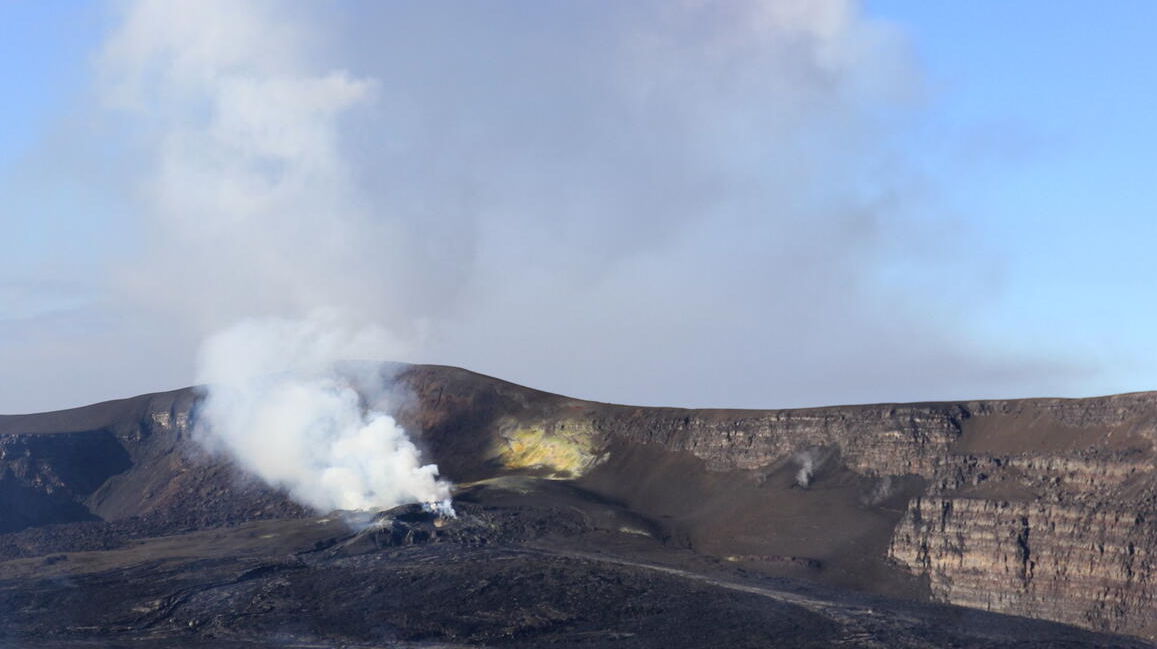
The ongoing summit eruption at Kīlauea is paused. Intermittent glow and tremor spikes indicative of gas pistoning have both paused over the last 24 hours. The onset of episode 39 is likely to occur between December 22 and 27.
Summit Observations:
In contrast to the previous 24-hour reporting period, no glow was observed at either vent overnight. This may have been due to low visibility conditions at the summit or an actual absence of glow. Also, the amplitude of volcanic tremor signals has decreased in the last 24 hours with tremor bursts indicative of gas-pistoning no longer occurring.
Since the end of episode 38, Kīlauea has inflated 25.0 microradians as recorded on the UWD tiltmeter this morning with an increase of 1.7 microradians in the last 24 hours.
Volcanic gas emission rates were measured yesterday at 3,400 tonnes per day of SO2. This rate is somewhat elevated relative to emission rates of 1,200 to 1,500 tonnes per day typically observed during previous eruptive pauses. In addition, this rate is elevated relative to non-eruptive background levels (around 100 tonnes per day).
Rift Zone Observations:
Rates of seismicity and ground deformation remain very low in the East Rift Zone and Southwest Rift Zone. SO2 emissions from the East Rift Zone remain below the detection limit.
Analysis:
The rapid rebound of inflationary tilt and presence of low level volcanic tremor indicate another fountain episode will occur. There are some discrepancies between the inflation models, but the onset of episode 39 is most likely between December 22 and 27. The forecast interval may change if the inflation rate varies.
Kīlauea has been erupting episodically since December 23, 2024, primarily from two vents (north and south) in Halema‘uma‘u. Eruptive episodes, which can last up to 12 hours, are separated by pauses that can be as long as over two weeks.
Source : HVO
Photo : H. Winslow
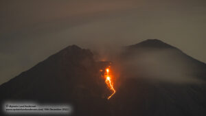
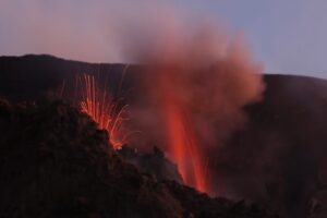
Indonesia , Marapi :
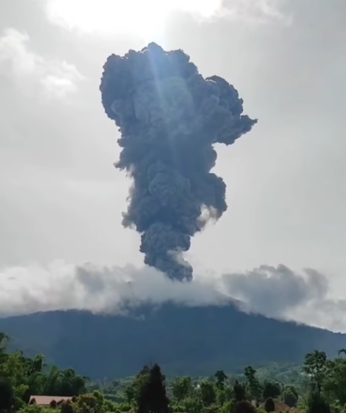
Mount Marapi erupted on Thursday, December 18, 2025, at 9:15 PM (local time). No visual observations of the eruption were made. The eruption was recorded by a seismograph with a maximum amplitude of 30.4 mm and a duration of 39 seconds.
Seismicity observations:
One eruption earthquake with an amplitude of 30.4 mm and a duration of 39 seconds.
Four emission earthquakes with amplitudes between 1 and 2.9 mm and a duration between 32 and 59 seconds.
Two non-harmonic tremors with amplitudes between 1 and 1.1 mm and a duration between 80 and 104 seconds.
One local tectonic earthquake with an amplitude of 1.7 mm and a duration of 24 seconds.
Five distant tectonic earthquakes with amplitudes between 1.6 and 5.5 mm and durations from 51 to 149 seconds.
One continuous tremor earthquake with amplitudes between 0.5 and 2 mm, predominantly 1 mm.
The Pusat Vulkanologi dan Mitigasi Bencana Geologi (PVMBG) reported that eruptive events at Marapi (on Sumatra) were recorded at 04h45 on 11 December and at 16h54 on 15 December, but were not visually observed due to weather conditions. At 16h37 on 14 December an ash plume rose 1.2 km above the crater rim and drifted N. The Alert Level remained at 2 (on a scale of 1-4) and the public was warned to stay 3 km away from the active crater.
Source : PVMBG , GVP.
Photo : Capture d’écran via Alex Terry / FB
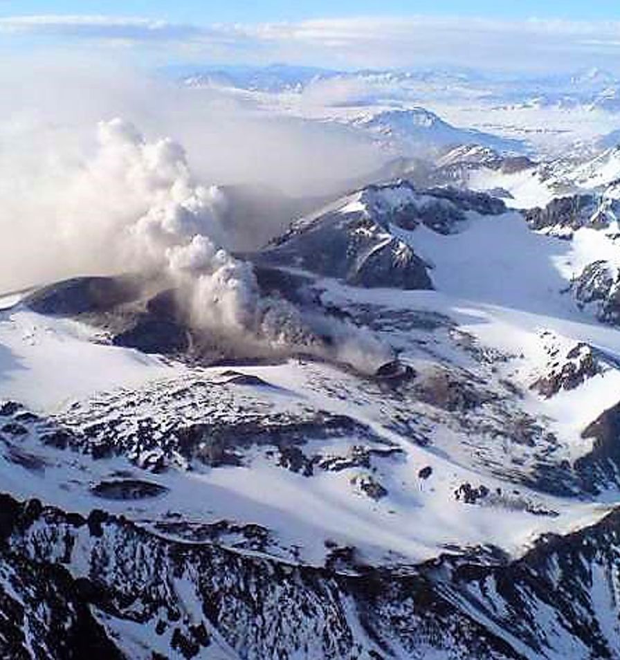
Kamchatka , Krasheninnikov :
The Kamchatkan Volcanic Eruption Response Team (KVERT) reported that eruptive activity at Krasheninnikov continued during 4-11 December. A large thermal anomaly over the volcano was identified in satellite images on all days except 9 December when weather clouds obscured views. The Aviation Color Code remained at Orange (the second highest level on a four-color scale). Dates and times are provided in Coordinated Universal Time (UTC); specific events are indicated in local time where specified.
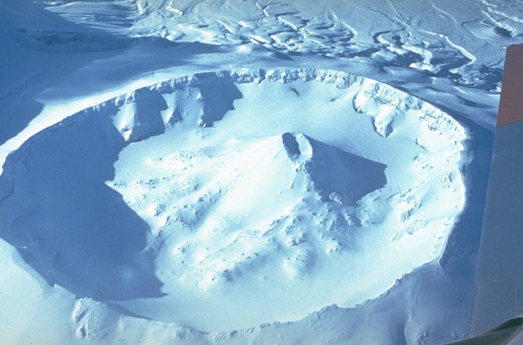
The late-Pleistocene to Holocene Krasheninnikov volcano is comprised of two overlapping stratovolcanoes within a 9 x 10 km Pleistocene caldera. Young lava flows from summit and flank vents descend both into the caldera and down its outer flanks, and older flows that covered much of the SE caldera rim extended downslope at least 7 km. Tephra deposits from the caldera-forming eruption directly overlie a 39,000 years before present (BP) tephra thought to be associated with the formation of Uzon caldera (Florenskii, 1988). The intra-caldera stratovolcanoes are situated along a NE-SW-trending fissure that has also produced zones of Holocene cinder cones extending 15-20 km beyond the caldera. Construction of the southern edifice began about 11,000 years BP and lasted for about 4,500 years; it has a summit crater about 800-900 m wide. The northern edifice was constructed during a cycle of similar length that began about 6,500 years ago; it has a summit crater about 1.5 km wide, within which is low cone with an 800-m-wide crater containing another small cone. An eruptive cycle during about 600-400 years BP (1350-1550 CE) produced the Pauk lava cone in the crater of the northern cone and the Yuzhny lava flow on SW flank outside the caldera, followed by the Molodoy flow from the upper SW flank (Ponomareva, 1987; Ponomareva and Tsyurupa, 1985; Ponomareva and Braitseva, 1990).
Sources : Kamchatkan Volcanic Eruption Response Team (KVERT) , GVP.
Photo : Yuri Doubik (Institute of Volcanology, Petropavlovsk), via GVP.
Colombia , Nevado del Ruiz :
Manizales, December 16, 2025, 5:45 PM
Regarding the monitoring of activity at the Nevado del Ruiz volcano, the Colombian Geological Survey (SGC), an agency under the Ministry of Mines and Energy, reports the following:
During the week of December 9-15, 2025, the volcano continued to exhibit unstable behavior. Compared to the previous week, the main variations in monitored parameters were as follows:
– Seismicity associated with fluid dynamics within the volcanic conduits, characterized by short-duration signals, increased in the number of events and in seismic energy released. The energy levels recorded were mostly low, sometimes moderate. Thanks to cameras (conventional and thermographic) used for monitoring the volcano and reports from staff at Los Nevados National Natural Park (PNNN), several pulsed ash emissions linked to these signals were confirmed.

Seismic activity associated with rock fracturing processes within the volcanic edifice maintained similar levels in terms of the number of recorded earthquakes and seismic energy released. The earthquakes were primarily located within the Arenas crater and on the volcano’s western, southwestern, southeastern, and northeastern flanks, within 7 km of the crater. Scattered earthquakes occurred on other flanks of the volcano, up to 12 km from the crater. The depth of these events ranged from less than 2 km to 8 km from the volcano’s summit. The maximum recorded magnitude was 1.2, corresponding to the earthquake recorded on December 12 at 3:26 a.m., located 6 km west-southwest of the crater at a depth of 5 km. Furthermore, on December 9, seismicity related to the activity of the lava dome (protuberance or mound) located at the bottom of the crater was recorded. This seismicity was of low energy and short duration.
– The emission of water vapor and volcanic gases, primarily sulfur dioxide (SO₂), from the Arenas crater into the atmosphere was variable. Estimated daily SO₂ flux rates increased compared to the previous week. However, this increase was partly due to favorable wind parameters (direction and speed) at the monitoring stations. Additional satellite monitoring continues to show low levels of SO₂ emissions.
– The vertical height of the column of gas, water vapor, or ash reached a maximum of 700 m, measured above the summit of the volcano, although it remained below 300 m for most of the time. Regarding the direction of dispersion, the column was primarily directed towards the west-northwest flank and, to a lesser extent, towards the northwest and south-southwest flanks of the volcanic structure. Monitoring of thermal anomalies at the bottom of the Arenas crater, using satellite platforms, revealed an increase in the number of detected anomalies, due to the favorable atmospheric conditions observed in the region in recent days. However, the energy of these anomalies remains low.
Source et photo : SGC.